- Upper Beaches
-
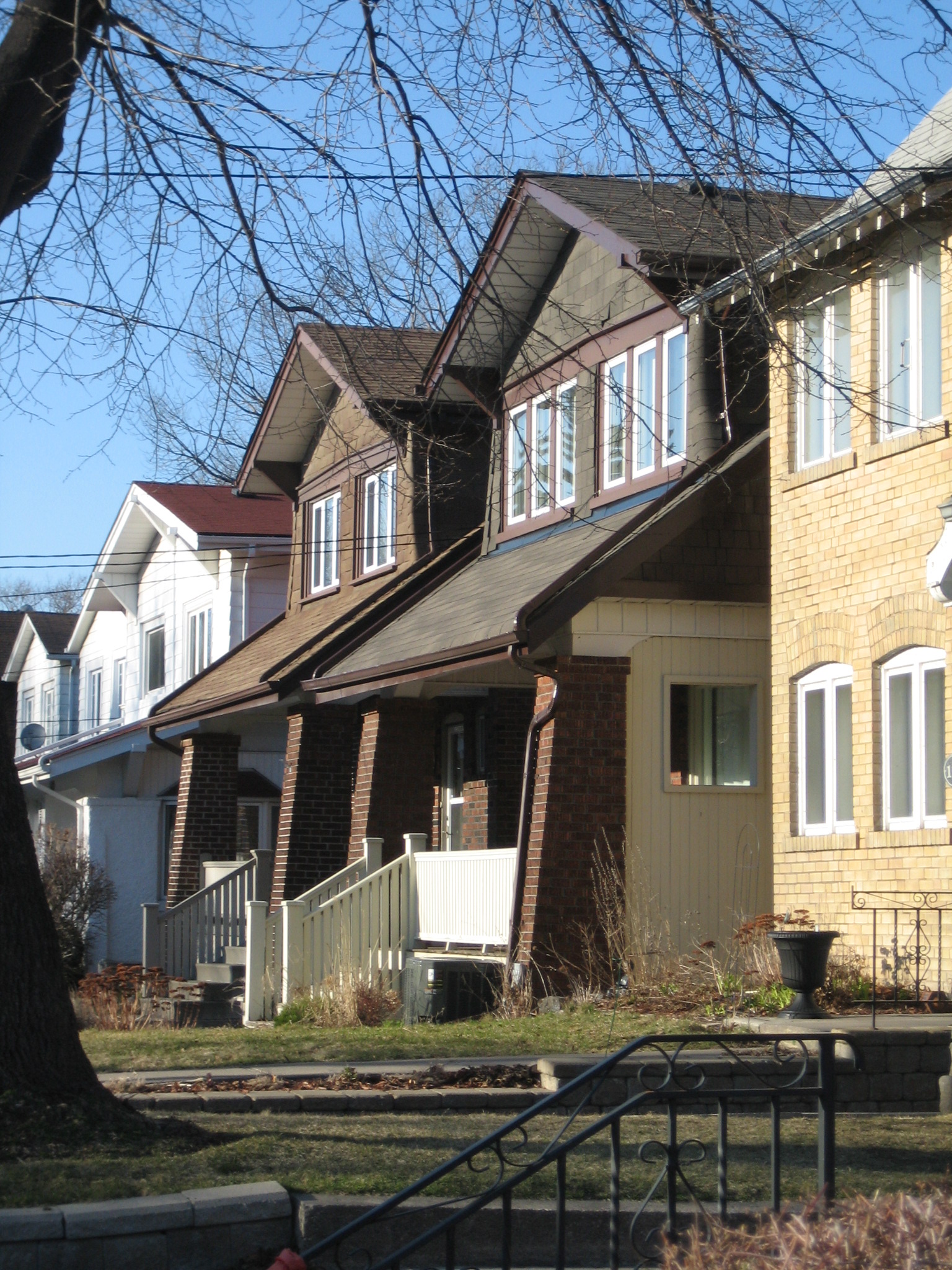
Upper Beaches — Neighbourhood — Typical houses in the Upper Beaches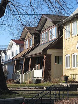 Vicinity
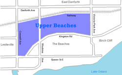 Location within Toronto

Coordinates: 43°40′26″N 79°18′29″W / 43.67389°N 79.30806°WCoordinates: 43°40′26″N 79°18′29″W / 43.67389°N 79.30806°W Country  Canada
Province  Ontario
City  Toronto
Community Toronto & East York Established 'Norway' Changed Municipality 1888 East Toronto from York
1908 Toronto (former) from East Toronto
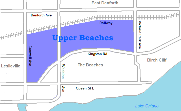
1998 Toronto from Toronto (former)Government - MP Matthew Kellway (Beaches-East York) - MPP Michael Prue (Beaches-East York) - Councillor Mary-Margaret McMahon (Ward 32 Beaches-East York) The Upper Beaches is a rather recently coined name for the neighbourhood directly north of the Beaches area in Toronto, Ontario, Canada. It stretches from Coxwell Avenue in the west to Victoria Park in the east. The southern border is Kingston Road, while the northern boundary is generally considered to be the CN tracks between Gerrard Street and Danforth Avenue. The eastern part of the area was originally called Norway, and the larger area was once part of the Town of East Toronto. The name "Upper Beaches" was first used by developers and real estate agents around the period of 2001 to 2003 for the selling of houses on redeveloped land in the area, and was used as a marketing tag to attract buyers. The area was never considered part of the Beaches neighborhood, but was close to it. The city's current name for this area is East End Danforth, though that is rarely used. The city also includes the buildings along and just north of Danforth Avenue in the neighbourhood. The western portion between Woodbine and Coxwell is referred to by the city as Woodbine Corridor.
History
- Norway
Predating development along Toronto's Beaches, Norway was a postal village in what is today the eastern part of Toronto. There is no evidence of Norwegian settlement in the area. Rather, the name likely comes from the Norway Pines that dominated the region, and whose harvesting was one of the main industries for the community. The most prominent landowner in the area was Charles Coxwell Small, who tried strenuously to have the town renamed to Berkeley, after his hometown in Britain. The name Norway stuck.
The village’s post office was originally a wooden structure built in 1825, today the site of 320 Kingston Road. The Norway Steam Mills, a steam powered saw mill began operations in 1835 near Woodbine and Kingston Road, established by the iron mongers, Wragg & Co., who advertised Norway pine as a specialty.
A toll gate resided at the Woodbine and Kingston Road. To the dismay of travelers, tolls were common along the stretch of Kingston Road during the 1800s as they funded the upkeep of the popular route from Toronto to Kingston, Ontario. It was main east-west land route through what was then defined as Upper Canada.
The community grew up in the 1840s around the toll station, saw mill and postal office becoming a popular stagecoach stop. The community was then at a distance of about 5 miles from the city at Woodbine, in a still largely wooded area. By 1850, the village’s population had reached 100. At this point, the village also included a few inns, three taverns, a school and a blacksmith’s shop.
One of the popular inns was The Norway House Hotel, standing on the south side of Kingston Road just east of Woodbine Avenue and was typical of many hotels in the suburbs of Toronto, heavily patronized by farmers on their way to and from market. Another was James Shaw’s Hotel and Tavern, described as a long low building painted dazzling white with green shutters.
In 1950 Charles Coxwell Small had donated 3 acres of land to be used for St John’s Church, Berkeley. His church was a wooden structure built in 1850 and served the Anglican community. In 1853 a cemetery was added to the property. In 1893 the brick structure that resides in place today was constructed and the church was re-named St. John's Cemetery Norway.
In 1909 The Village of Norway was annexed to the expanding City of Toronto, one year after its neighbour to the east, East Toronto. The village of Norway has long since been fully engulfed by the City of Toronto. Its name does persist in a number of places, including Norway Avenue, and the nearby Norway Public School. St. John the Baptist Norway Anglican Church, the attached St. John's Cemetery Norway were named after Canada's original patron; the later St John's Roman Catholic church and school also preserve the name.
- Midway
Midway was a name given to the open land north of Dundas Street and Kingston Road (an approximation as there were no distinct boundaries in place) between Toronto’s city limits of Greenwood Avenue and the Town of East Toronto. As its name suggests, it was the midway point between these two townships. The area consisted primarily of farming land, much of which was vacant.
In year 1873, the Toronto Golf Club had taken up residence in some of this open space between Woodbine and Coxwell, sitting just to the northwest of The Village of Norway.
The Toronto Golf Club was the third oldest Golf Club in Canadian history and hosted the Canadian open at this location twice in its history (1905 and 1909). An old mansion on the property was renovated to become the clubhouse.
The areas of Midway and Norway continued to grow heading towards the 1900s, becoming increasingly crowded. A lack of adequate sewage systems caused many illnesses and the schools were becoming crowded. Feeling boxed in by an encroaching population, the Toronto Golf Club sought a new residence and sold their land on advantageous terms. They moved out to Toronto’s west end and home of their present site.
In 1909 Midway and Norway were officially annexed to the growing City of Toronto. The Toronto Civic Railway would begin construction of a line stretching between Greenwood to East Toronto’s Main Street. The railway line flowed along Gerrard Street East, turning north on Coxwell and re-continuing east on a footpath used by the former golf club, now Upper Gerrard Street East. This route still exists today as the TTC 506 Carlton.
The new owners of the former golf club were a land developers by the name of Robin’s Group. They renamed the developing area Kelvin Park, posting regular ads in The Globe and Mail selling parcels of land perfect for the construction of new homes. They setup a sales office on Gerrard and Greenwood and offer to drive prospective buyers from the office to Kelvin Park. In their ads, they offer plots of land for sale touting the recent installation of the Toronto Civic Railway line along with the scenic view of the lake, picturesque glens and winding stream fringed with beautiful trees. These ads ran until 1913.
- Town of East Toronto
A large part of the neighbourhood was laid out later as the residential heart of the short lived Town of East Toronto. Until recent years the neighbourhood was largely working class, with lower prices than the Beaches to the south. In the last two years a marked rise in housing costs has forced many of the lower class earners to move east of the area. The area was also home to a number of industrial sites alongside the rail line, which runs just north of Gerrard. Today almost all of the industry has been forced out, and replaced by large housing developments. It is one of a group of neighbourhoods, such as the South Annex and South Riverdale that have been snapped up quickly by lower-middle-class young couples and families, as the older downtown neighbourhoods have become dramatically more expensive.
Residents in the neighbourhood are primarily lower-middle to upper-class earners, although there is yet a healthy mix across the spectrum. The housing types range from squat apartment buildings to particle-board-based single detached brick construction housing. Since there are limited links to the Danforth due to the local rail line to the north, the nearest main commercial strip in the area is much further south at Kingston Road, which is home to a thriving mix of small shops and restaurants.
Transportation
The area is served by the 502 Downtowner and 503 Kingston Rd streetcar routes along Kingston Road and the 506 Carlton streetcar along Gerrard, from its terminus at Main Street Station on the subway line.
External links

East Danforth Leslieville 
Birch Cliff (Scarborough)  Upper Beaches

The Beaches Categories:- Neighbourhoods in Toronto
Wikimedia Foundation. 2010.