- Moore Park, Toronto
-
Moore Park — Neighbourhood — Vicinity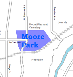 Location within Toronto

Country  Canada
Province  Ontario
City  Toronto
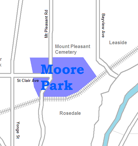
Moore Park is a neighbourhood in Toronto, Ontario, Canada. It lies along both sides of St. Clair Avenue East between the Vale of Avoca section of Rosedale ravine and Moore Park ravine (formerly Spring Valley ravine). The northern boundary is Mount Pleasant Cemetery and the southern the Canadian Pacific Railway tracks.
The neighbourhood takes its name from its developer, John T. Moore. To encourage buyers, he built two bridges in 1891: the original steel bridge on St. Clair over the Vale of Avoca, and the original wooden bridge on Moore Avenue over Spring Valley ravine. He also helped establish railway service to the neighbourhood. The development was marketed to the wealthy, and the neighbourhood remains wealthy. Moore Park was annexed by the City of Toronto on December 16, 1912.[1]
Census tract 0125.00 of the 2006 Canadian census covers Moore Park. According to that census, the neighbourhood has 4,474 residents, down 2% from the 2001 census. Average income is $154,825, one of the highest incomes of all Toronto neighbourhoods, and not far below neighbouring Rosedale. The neighbourhood is almost entirely English speaking.
See also
- Loring-Wyle Parkette
- Lytton Park
References
- ^ Bridge over Vale of Avoca, Deer Park Library
- Joan C. Kinsella, Historical Walking Tour of Deer Park, Toronto Public Library Board, 1996
External links

Davisville Village Deer Park 
Leaside
Playter Estates Moore Park

Rosedale Former municipalities of Toronto by year of amalgamation 1883-1912 1883: Yorkville · 1884: Brockton · Riverdale · 1888: Seaton Village · 1889: Parkdale · 1890: Bedford Park · Davisville · 1905: Rosedale · 1908: Deer Park · East Toronto · 1909: Bracondale · West Toronto · Wychwood · 1910: Moore Park · North Toronto · 1912: Dovercourt · Earlscourt1967 1998 Categories:- Neighbourhoods in Toronto
- Former municipalities in Toronto
- Toronto geography stubs
Wikimedia Foundation. 2010.