- Cities and towns in West Bengal
-
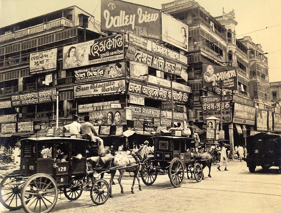
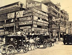 Image of Harrison Street Strand Road and Burra Bazaar in Kolkata (Calcutta) in 1945, shortly before the urban expansion of West Bengal
West Bengal is the state with highest population density in India.[1] The state is dotted with several small and medium towns and cities. Historically, the main source of income of the people of West Bengal has been farming, and, as a consequence, the state previously had a large rural population skew. At the turn of the 20th century, however, the role of industry in West Bengal increased substantially, leading to a population move into urban areas.
In 1947, when India gained independence, the erstwhile British Indian province of Bengal was divided into two parts: the eastern region formed East Pakistan -- which became Bangladesh in 1971 — and the western part joined India as the state of West Bengal. Scores of refugees from the eastern part came to West Bengal, leading to the start of new urban areas, and contributing to the congestion of already established cities like Kolkata.
Contents
Classification
As of 2001[update] India census,[2] 375 cities and towns in West Bengal can be classified in the following categories:
- 2 Urban agglomeration (UA): Kolkata, Kolkata Municipal Corporation is responsible for civic administration of the city, whereas Kolkata Metropolitan Development Authority is responsible for Greater Kolkata, the UA.Siliguri, Asansol, Durgapur forms the other UA.[3]
- 6 Municipal Corporations: Kolkata, Asansol, Chandannagar, Durgapur, Howrah and Siliguri.
- 114 Municipalities: Alipurduar, Arambag, Ashoknagar Kalyangarh, Baduria, Baharampur, Baidyabati, Bally, Balurghat, Bangaon, Bankura, Bansberia, Baranagar, Barasat, Barddhaman, Barrackpur, Baruipur, Basirhat, Beldanga, Bhadreswar, Bhatpara, Bidhan Nagar, Birnagar, Bishnupur, Bolpur, Budge Budge, Cannin, Chakdaha, Champdani, Chandrakona, Contai, Dainhat, Darjiling, Dhulian, Diamond Harbour, Dinhata, Dubrajpur, Dumdum, Egra, English Bazar, Falakata, Gangarampur, Garulia, Gayespur, Ghatal, Gobardanga, Guskara, Habra, Haldia, Haldibari, Halisahar, Hugli-Chinsurah, Islampur, Jalpaiguri, Jamuria, Jangipur, Jaynagar Mazilpur, Jhalda, Jhargram, Jiaganj Azimganj, Kaliaganj, Kalimpong, Kalna, Kalyani, Kamarhati, Kanchrapara, Kandi, Katwa, Kharagpur, Kharar, Khardaha, Koch Bihar, Konnagar, Krishnanagar, Kshirpai, Kulti, Kurseong, Madhyamgram, Maheshtala, Mal, Mathabhanga, Medinipur, Mekliganj, Memari, Mirik, Murshidabad, Nabadwip, Naihati, New Barrackpur, North Barrackpur, North Dumdum, Old Maldah, Panihati, Pujali, Puruliya, Raghunathpur, Raiganj, Rajarhat Gopalpur, Rajpur Sonarpur, Ramjibanpur, Rampurhat, Ranaghat, Raniganj, Rishra, Sainthia, Santipur, Serampore, Sonamukhi, South Dumdum, Suri, Taki, Tamluk, Tarakeswar, Titagarh, Tufanganj, Uluberia and Uttarpara Kotrung.
- 2 notified area: Cooper's Camp and Taherpur
- 1 cantonment: Barrackpur Cantonment and
- 252 census towns.
Now, number of municipalities has been increased to 117 as four new municipalities have been established: Nalhati (2000), Dhupguri (2001), Panskura (2001) and Dalkhola (2003).[4] So, the number of census towns is now reduced to 250 as Dhupguri and Dalkhola have been upgraded to municipality.
Major cities

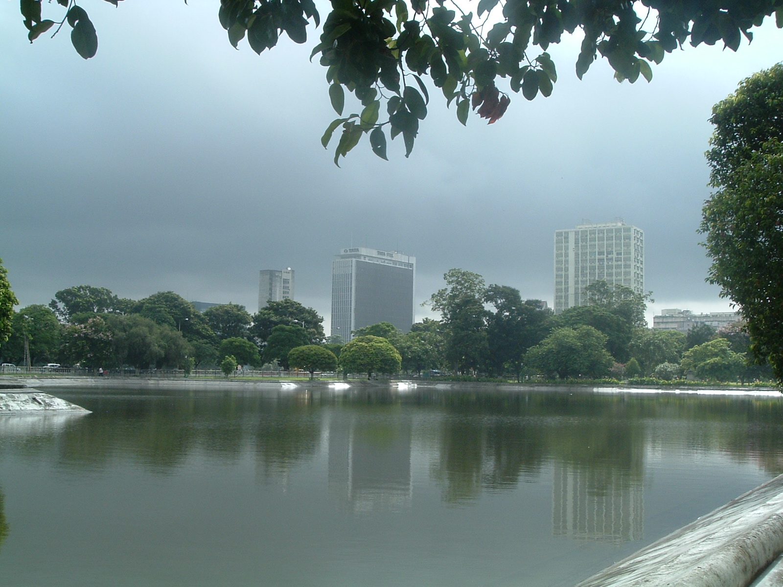
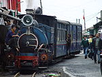 Toy Train approaching Darjeeling
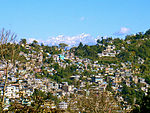 Kalimpong, as viewed from a distance, showing the urban arrangement necessitated by the geography of some parts of the state.
Name Coordinates Area[4] Status[4] Population As of 2001[update][4] Population Density Importance Kolkata 22°34′N 88°22′E / 22.57°N 88.37°E 187.50 km2 (72.39 sq mi) Municipal Corporation 4580544 24,430 /km2 (63,300 /sq mi) The capital of West Bengal. It was the capital of the of British India until 1911. Kolkata is one of the four big cities in India, and is one of the largest urban agglomerations in the world. Howrah 22°35′N 88°19′E / 22.59°N 88.31°E 51.74 km2 (19.98 sq mi) Municipal Corporation 1008704 19,496 /km2 (50,490 /sq mi) A primarily industrial city, and the second largest city in West Bengal. It is located on the west bank of the Hooghly River, and is the twin city to Kolkata. Headquarters of the Howrah district. Darjeeling 27°02′N 88°10′E / 27.03°N 88.16°E 10.57 km2 (4.08 sq mi) Municipality 107530 10,173 /km2 (26,350 /sq mi) It is a famous hill station and tourist destination. It is also known for its access route, the Darjeeling Himalayan Railway, Darjeeling tea, and historical role of the city as a summer retreat. Headquarters of the Darjeeling district. Kalimpong 27°04′N 88°28′E / 27.06°N 88.47°E 8.67 km2 (3.35 sq mi) Municipality 42980 4,957 /km2 (12,840 /sq mi) It is a hill station in the Darjeeling district. It is known as a tourist destination, especially for its climate, and for its Buddhist monasteries and flower market. Kharagpur 22°20′N 87°20′E / 22.33°N 87.33°E 90.65 km2 (35.00 sq mi) Municipality 207984 2,294 /km2 (5,940 /sq mi) The fifth largest city of West Bengal (by area) is famous for the Indian Institute of Technology. Also has the longest railway platform in the world in its railway station, and a major air force base nearby. Bardhaman 23°15′N 87°51′E / 23.25°N 87.85°E 48.00 km2 (18.53 sq mi) Municipality 285871 5,956 /km2 (15,430 /sq mi) Headquarters of the Bardhaman district. Asansol 23°41′N 86°59′E / 23.68°N 86.98°E 127.24 km2 (49.13 sq mi) Municipal Corporation 486304 3,822 /km2 (9,900 /sq mi) An industrial town in the Bardhaman District. It is known for its famous iron and steel works and the locomotive works at Chittaranjan. It is the third largest city of West Bengal. Durgapur 23°29′N 87°19′E / 23.48°N 87.32°E 154.20 km2 (59.54 sq mi) Municipal Corporation 492996 3,197 /km2 (8,280 /sq mi) An industrial town in the Bardhaman District, famous for the National Institute of Technology, Durgapur and the Central Mechanical Engineering Research Institute the commercial capital of the Rarh region, a large industrial city with well-planned roads and townships. The fourth largest city in West Bengal. Murshidabad 24°11′N 88°16′E / 24.18°N 88.27°E 12.95 km2 (5.00 sq mi) Municipality 160168 12,368 /km2 (32,030 /sq mi) It was the capital of Bengal before British Raj. Malda 25°00′N 88°09′E / 25.00°N 88.15°E 13.25 km2 (5.12 sq mi) Municipality 161448 12,185 /km2 (31,560 /sq mi) It was the capital of Bengal from 5th century BC till the time of Muslim rule. The relics are at Gaur and Pandua. Siliguri 26°43′N 88°26′E / 26.71°N 88.43°E 41.90 km2 (16.18 sq mi) Municipal Corporation 470275 11,224 /km2 (29,070 /sq mi) An arterial city in North Bengal, one of the most important business hubs in the state and the entire north-eastern region of India. It is the fifth largest city of the state and the second most important trade hub after Kolkata. Jalpaiguri 26°31′N 88°44′E / 26.52°N 88.73°E 12.97 km2 (5.01 sq mi) Municipality 100212 7,726 /km2 (20,010 /sq mi) Headquarters of the Jalpaiguri district. Raiganj 25°37′N 88°07′E / 25.62°N 88.12°E 8.99 km2 (3.47 sq mi) Municipality 165222 18,378 /km2 (47,600 /sq mi) Headquarters of the district North Dinajpur. Balurghat 25°13′N 88°46′E / 25.22°N 88.77°E 8.56 km2 (3.31 sq mi) Municipality 135516 15,831 /km2 (41,000 /sq mi) Headquarters of the district South Dinajpur. Purulia 23°20′N 86°22′E / 23.33°N 86.37°E 13.93 km2 (5.38 sq mi) Municipality 113766 8,167 /km2 (21,150 /sq mi) Headquarters of the Purulia district. Baharampur 24°06′N 88°15′E / 24.1°N 88.25°E 31.42 km2 (12.13 sq mi) Municipality 160168 5,098 /km2 (13,200 /sq mi) Also called Berhampore. It is the headquarters of Murshidabad district. Krishnanagar 23°24′N 88°30′E / 23.4°N 88.5°E 15.96 km2 (6.16 sq mi) Municipality 139070 8,714 /km2 (22,570 /sq mi) Headquarters of the Nadia district. Barasat 22°14′N 88°27′E / 22.23°N 88.45°E 34.50 km2 (13.32 sq mi) Municipality 231515 6,711 /km2 (17,380 /sq mi) Headquarters of the North 24 Parganas district. Barrackpore 22°46′N 88°22′E / 22.76°N 88.37°E 11.65 km2 (4.50 sq mi) Municipality 144411 12,396 /km2 (32,110 /sq mi) The first army barrack of the British East India Company was established here. Also, the first sparks of 1857 Indian mutiny is said to have started from this city. It is now a northern suburb of Kolkata. Ranaghat 23°11′N 88°35′E / 23.18°N 88.58°E 7.72 km2 (2.98 sq mi) Municipality 68754 8,906 /km2 (23,070 /sq mi) It is one of the important rail stations in eastern railway and a communication link between north and south Bengal, also it's a growing market. Serampore 22°45′N 88°20′E / 22.75°N 88.34°E 14.50 km2 (5.60 sq mi) Municipality 197955 13,652 /km2 (35,360 /sq mi) A city of the Danish East India Company. Chandannagar 22°52′N 88°23′E / 22.87°N 88.38°E 20.00 km2 (7.72 sq mi) Municipal Corporation 162166 8,108 /km2 (21,000 /sq mi) A city built by the French East India Company. Chinsura 22°54′N 88°23′E / 22.90°N 88.39°E 17.29 km2 (6.68 sq mi) Municipality 170201 9,844 /km2 (25,500 /sq mi) Headquarters of the Hooghly district. Kalyani 22°59′N 88°29′E / 22.98°N 88.48°E 29.14 km2 (11.25 sq mi) Municipality 81984 2,813 /km2 (7,290 /sq mi) The northernmost part of the Kolkata urban agglomeration, Kalyani was the brainchild of the second chief minister of the state, Dr. Bidhan Chandra Roy. It is a planned township and is divided into residential, industrial and educational sectors. Tamluk 22°18′N 87°55′E / 22.3°N 87.92°E 10.42 km2 (4.02 sq mi) Municipality 45826 4,398 /km2 (11,390 /sq mi) Headquarters of the district Midnapore East. Medinipur 22°15′N 87°39′E / 22.25°N 87.65°E 18.36 km2 (7.09 sq mi) Municipality 153349 8,352 /km2 (21,630 /sq mi) Headquarters of the district Midnapore West. Nabadwip 23°15′N 88°13′E / 23.25°N 88.22°E 12 km2 (4.6 sq mi) Municipality 125341 10,500 /km2 (27,000 /sq mi) Nabadwip was capital of old Bengal(A.D. 1169-A.D.1206).It was place of culture,literature,religion.Lord Sri Chaityanya was born here.It is noted holy place for Hindus. Contai 21°47′N 87°45′E / 21.78°N 87.75°E 14.25 km2 (5.50 sq mi) Municipality 77497 5,438 /km2 (14,080 /sq mi) Near the tourist attraction, Digha. Cooch Behar 26°11′N 89°16′E / 26.19°N 89.26°E 8.19 km2 (3.16 sq mi) Municipality 76812 2,053 /km2 (5,320 /sq mi) Headquarters of the Cooch Behar district. Bankura 23°15′N 87°04′E / 23.25°N 87.07°E 19.06 km2 (7.36 sq mi) Municipality 128811 6,758 /km2 (17,500 /sq mi) Headquarters of the Bankura district. Bishnupur 23°05′N 87°19′E / 23.08°N 87.32°E 22.01 km2 (8.50 sq mi) Municipality 61943 2,814 /km2 (7,290 /sq mi) A city of archeological importance. Haldia 22°02′N 88°04′E / 22.03°N 88.06°E 109.65 km2 (42.34 sq mi) Municipality 170695 1,557 /km2 (4,030 /sq mi) Most important among upcoming industrial hubs of the state. Home to major petrochemical houses, it is set to become the most important port in the region. Suri 23°55′N 87°32′E / 23.92°N 87.53°E 9.47 km2 (3.66 sq mi) Municipality 61818 6,528 /km2 (16,910 /sq mi) Headquarters of the Birbhum district. Bolpur 23°40′N 87°43′E / 23.67°N 87.72°E 13.13 km2 (5.07 sq mi) Municipality 65659 5,001 /km2 (12,950 /sq mi) the city near which Santiniketan is located. |- |
List of urban areas (district-wise)
References
- ^ 903 per sq. km. "India at a glance: Population Density". Census of India, 2001. http://www.censusindia.gov.in/Census_Data_2001/India_at_glance/density.aspx. Retrieved 2008-12-13.
- ^ "Census of India 2001: Data from the 2001 Census, including cities, villages and towns (Provisional)". Census Commission of India. Archived from the original on 2004-06-16. http://web.archive.org/web/20040616075334/http://www.censusindia.net/results/town.php?stad=A&state5=999. Retrieved 2008-11-01.
- ^ "List of Million Plus Cities of India". Census of India. http://www.censusindia.gov.in/Census_Data_2001/Census_Data_Online/Population/List_of_Million_Plus_Cities.aspx. Retrieved 2008-10-14.
- ^ a b c d e f "Category, Year of Establishment, Area, SC, ST and total population in ULBs in West Bengal". Department of Municipal affairs, Government of West Bengal. http://wbdma.gov.in/pdf/b.pdf. Retrieved 2008-11-09.
- ^ "List of Census Towns, West Bengal, 2001". Census of India, Directorate of Census Operations, West Bengal. http://web.cmc.net.in/wbcensus/DataTables/01/TABLE-3B.htm. Retrieved 2008-12-15.
- ^ Rishra census town is separate urban unit from Rishra municipality
Categories:


Wikimedia Foundation. 2010.