- Sundarbans
Infobox World Heritage Site
WHS = The Sundarbans
State Party =West Bengal (India ),Bangladesh
Type = Natural
Criteria = ix, x
ID = 798
Region = Asia-Pacific
Year = 1997
Session = 21st
Link = http://whc.unesco.org/en/list/798The Sundarbans ( _bn. সুন্দরবন "Shundorbôn") is the largest single block of tidal halophytic
mangrove forest in the world.Citation | last = Pasha | first = Mostafa Kamal | last2 = Siddiqui | first2 = Neaz Ahmad | contribution = Sundarbans | editor-last = Islam | editor-first = Sirajul | editor-link = Sirajul Islam | title =Banglapedia : national encyclopedia of Bangladesh | publisher =Asiatic Society of Bangladesh | place =Dhaka | isbn = 9843205766 | publication-date = 2003 | contribution-url = http://banglapedia.net/HT/S_0602.HTM] "Sundarban" literally means "beautiful jungle" or "beautiful forest" in theBengali language . The name Sundarbans may also have been derived from the "Sundari" trees that are found in Sundarbans in large numbers. Other possible explanations can be a derivation from "Samudraban" ( _bn. সমুদ্রবন "Shomudrobôn" "Sea Forest") or "Chandra-bandhe" (name of a primitive tribe). But the generally accepted view is the one associated with "Sundari" trees.The forest lies at the mouth of the
Ganges and is spread across areas ofBangladesh andWest Bengal ,India , forming the seaward fringe of the delta. The forest covers 10,000 sq.km of which about 6,000 are in Bangladesh. [ [http://www.sundarbantigerproject.info/viewpage.php?page_id=3 Sundarbans Tiger Project ] ] It became inscripted as aUNESCO world heritage site in1997 , but while the Bangladeshi and Indian portions constitute the same continuousecotope , these are separately listed in theUNESCO world heritage list as the Sundarbans andSundarbans National Park , respectively. The Sundarbans is intersected by a complex network of tidal waterways,mudflat s and smallislands of salt-tolerant mangrove forests. The area is known for theeponym ous Royal Bengal Tiger, as well as numerous fauna including species ofbird s, spotteddeer ,crocodile s andsnake s. It is estimated that there are now 500Fact|date=July 2008 Bengal tigers and about 30,000 spotted deer in the area. Sundarbans was designated aRamsar site on May 21, 1992History
During the Mughal period (1203-1538), the local kings leased the forests of the Sundarbans out. The history of changes in legal status boasts a number of unique features including the distinction of being the first mangrove forest in the world to be brought under scientific management. The area was mapped by the Surveyor General as early as 1764 following soon after proprietary rights were obtained from the Mughal Emperor, Alamgir II, by the East India Company in 1757. Systematic management of this forest tract started in the 1860s after the establishment of a Forest Department in the Province of Bengal, in India.
The first Forest Management Division to have jurisdiction over the Sundarbans was established in 1869. The Sundarbans was declared a reserved forest in 1875-76, under the Forest Act, 1865 (Act VIII of 1865). The first management plan was written for the period 1893-98.Hussain, Z. and G. Acharya, 1994. (Eds.) Mangroves of the Sundarbans. Volume two : Bangladesh. IUCN, Bangkok, Thailand. 257 p.] [UNDP, 1998. Integrated resource development of the Sundarbans Reserved Forests, Bangladesh. Volume I Project BGD/84/056, United Nations Development Programme, Food and Agriculture Organization of the United Nations, Dhaka, The People’s Republic of Bangladesh. 323 p.] In 1875 a large portion of the mangrove forests was declared as reserved forests under the Forest Act, 1865 (Act VIII of 1865). The remaining portions of forests was declared as reserve forest the following year and the forest, which was so far was administered by the civil administration district, was placed under the control of the Forest Department. A Forest Division, which is the basic forest management and administration unit, was created in 1879 with the headquarter in Khulna.
In 1911, it was described as a tract of waste country which had never been surveyed, nor had the census been extended to it. It then stretched for about convert|165|mi|km|0 from the mouth of the Hugli to the mouth of the Meghna, and was bordered inland by the three settled districts of the Twenty-four Parganas, Khulna and Backergunje. The total area (including water) was estimated at convert|6526|sqmi|km2|0. It was a water-logged jungle, in which tigers and other wild beasts abounded. Attempts at reclamation had not been very successful. The characteristic tree was the "Sundari" ("Heritiera littoralis"), from which the name of the tract had probably been derived. It yields a hard wood, used for building, and for making boats, furniture, etc. The Sundarbans were everywhere intersected by river channels and creeks, some of which afforded water communication between
Kolkata and the Brahmaputra valley, both for steamers and for native boats.Physiography
The mangrove-dominated Ganges delta – the Sundarbans - is a complex ecosystem comprising one of the three largest single tract of mangrove forests of the world. Shared between two neighboring countries, Bangladesh and India, the larger part (62%)is situated in the southwest corner of Bangladesh. To the south the forest meets the
Bay of Bengal ; to the east it is bordered by theBaleswar River and to the north there is a sharp interface with intensively cultivated land. The natural drainage in the upstream areas, other than the main river channels, is everywhere impeded by extensive embankments andpolder s. The Sundarbans was originally measured (about 200 years ago) to be of about 16,700 km². Now it has dwindled to about 1/3 of the original size. The total land area today is 4,143 km² (including exposed sandbars: 42 km²) and the remaining water area of 1,874 km² encompasses rivers, small streams and canals. Rivers in the Sundarbans are meeting places of salt water and freshwater. Thus, it is a region of transition between the freshwater of the rivers originating from the Ganges and the saline water of the Bay of Bengal (Wahid "et al.". 2002).The Sundarbans along the
Bay of Bengal has evolved over the millennia through natural deposition of upstream sediments accompanied by intertidal segregation. The physiography is dominated by deltaic formations that include innumerable drainage lines associated with surface and subaqueous levees, splays and tidal flats. There are also marginal marshes above mean tide level, tidal sandbars and islands with their networks of tidal channels, subaqueous distal bars and proto-delta clays and silt sediments. The Sundarbans' floor varies from 0.9 m to 2.11 m above sea level. [Katebi, M.N.A. and M.G. Habib, 1987. Sundarbans and Forestry in Coastal Area Resource Development and Management Part II, BRAC Printers, Dhaka, Bangladesh. 107 p.]Biotic factors here play a significant role in physical coastal evolution and for wildlife a variety of habitats have developed including beaches, estuaries, permanent and semi-permanent swamps, tidal flats, tidal creeks, coastal dunes, back dunes and levees. The mangrove vegetation itself assists in the formation of new landmass and the intertidal vegetation plays an important role in swamp morphology. The activities of mangrove fauna in the intertidal mudflats develop micromorphological features that trap and hold sediments to create a substratum for mangrove seeds. The morphology and evolution of the eolian dunes controlled by an abundance of
xerophytic andhalophytic plants. Creepers and grasses and sedges stabilizes sand dunes and uncompacted sediments.Climate change impact
The physical development processes along the coast are influenced by a multitude of factors, comprising wave motions, micro and macro-tidal cycles and long shore currents typical to the coastal tract. The shore currents vary greatly along with the
monsoon . These are also affected by cyclonic action. Erosion and accretion through these forces maintains varying levels, as yet not properly measured, of physiographic change whilst the mangrove vegetation itself provides a remarkable stability to the entire system. During each monsoon season almost all the Bengal Delta is submerged, much of it for half a year. The sediment of the lower delta plain is primarily advected inland by monsoonal coastal setup and cyclonic events. One of the greatest challenges people living on theGanges Delta may face in coming years is the threat of rising sea levels caused mostly bysubsidence in the region and partly by climate change.In many of the Indian mangrove wetlands, freshwater reaching the mangroves was considerably reduced from the late 19th century due to diversion of freshwater in the upstream area. Also, the Bengal Basin is slowly tilting towards the east due to neo-tectonic movement, forcing greater freshwater input to the Bangladesh Sundarbans. As a result, the salinity of the Bangladesh Sundarbans is much lower than that of the Indian Sundarbans. A 1990 study noted that there "is no evidence that environmental degradation in the Himalayas or a 'greenhouse' induced rise in sea level have aggravated floods in Bangladesh"; however, a 2007 report by UNESCO, "Case Studies on Climate Change and World Heritage" has stated that an anthropogenic 45-cm rise in sea level (likely by the end of the twenty-first century, according to the Intergovernmental Panel on Climate Change), combined with other forms of anthropogenic stress on the Sundarbans, could lead to the destruction of 75% of the Sundarbans mangroves. [ [http://whc.unesco.org/documents/publi_climatechange.pdf Case Studies of Climate Change] , UNESCO, 2007]
Flora
The Sundarbans flora is characterized by the abundance of "Heritiera fomes", "Excoecaria agallocha", "Ceriops decandra" and "Sonneratia apetala". A total 245 genera and 334 plant species were recorded by
David Prain in 1903. [Prain, D. 1903. The flora of Sundarbans. Records of the Botanical Survey of India. 114: 231-272.] Since Prain’s report there have been considerable changes in the status of various mangrove species and taxonomic revision of the man-grove flora. [Khatun, B.M.R. and M.K. Alam, 1987. Taxonomic studies in the genus "Avicennia" L. from Bangladesh. Bangladesh J. Bot. 16(1): 39-44.] However, very little exploration of the botanical nature of the Sundarbans has been made to keep up with these changes. Whilst most of the mangroves in other parts of the world are characterized by members of the Rhizophoraceae,Avicenneaceae orLaganculariaceae , the mangroves of Bangladesh are dominated by the Sterculiaceae and Euphorbiaceae.The Bangladesh mangrove vegetation of the Sundarbans differs greatly from other non-deltaic coastal mangrove forest and upland forests associations. Unlike the former, the Rhizophoraceae are of minor importance. Differences in vegetation have been explained in terms of freshwater and low salinity influences in the Northeast and variations in drainage and siltation. The Sundarbans has been classified as a moist tropical forest demonstrating a whole mosaic of seres, comprising primary colonization on new accretions to more mature beach forests, often conspicuously dominated by Keora ("
Sonneratia apetala ") and tidal forests. Historically three principal vegetation types have been recognized in broad correlation with varying degrees of water salinity, freshwater flushing and physiography and which are represented in the wildlife sanctuaries:Sundari and Gewa occur prominently throughout the area with discontinuous distribution of Dhundul ("
Xylocarpus granatum ") and Kankra. Among grasses and Palms, "Poresia coaractata ", "Myriostachya wightiana ", "Imperata cylindrica ", "Phragmites karka ", "Nypa fruticans " are well distributed. Keora is an indicator species for newly accreted mudbanks and is an important species for wildlife, especially spotted deer ("Axis axis "). Besides the forest, there are extensive areas ofbrackish andfreshwater marshes ,intertidal mudflat s,sandflat s,sand dune s with typical dune vegetation, opengrassland on sandy soils and raised areas supporting a variety of terrestrial shrubs and trees.Succession is generally defined as the successive occupation of a site by different plant communities. [Weaver, J.E. and F.E. Clements, 1938. Plant Ecology. McGraw-Hill Book Company, Inc. New York. 601 p.] In an accreting mudflats the outer community along the sequence represents the pioneer community which is gradually replaced by the next community representing the seral stages and finally by a climax community typical of the climatic zone. [Watson, J.G. 1928. Mangrove swamps of the Malayan peninsula. Malayan Forest Records 6:1-275.] Troup suggested that succession began in the newly accreted land created by fresh deposits of eroded soil. [Troup, R.S. 1921. The Silviculture of Indian Trees. Clarendon Press, Oxford. 1195 p.]
The pioneer vegetation on these newly accreted site is "
Sonneratia ", followed by "Avicennia " and "Nypa ". As the ground is elevated as a result of soil deposition, other trees make their appearance. The most prevalent, though one of the late species to appear, is "Excoecaria ". As the level of land rises through accretion and the land is only occasionally flooded by tides, "Heritiera fomes" begins to appear.Fauna
Image stack
align= right
image_size= 220px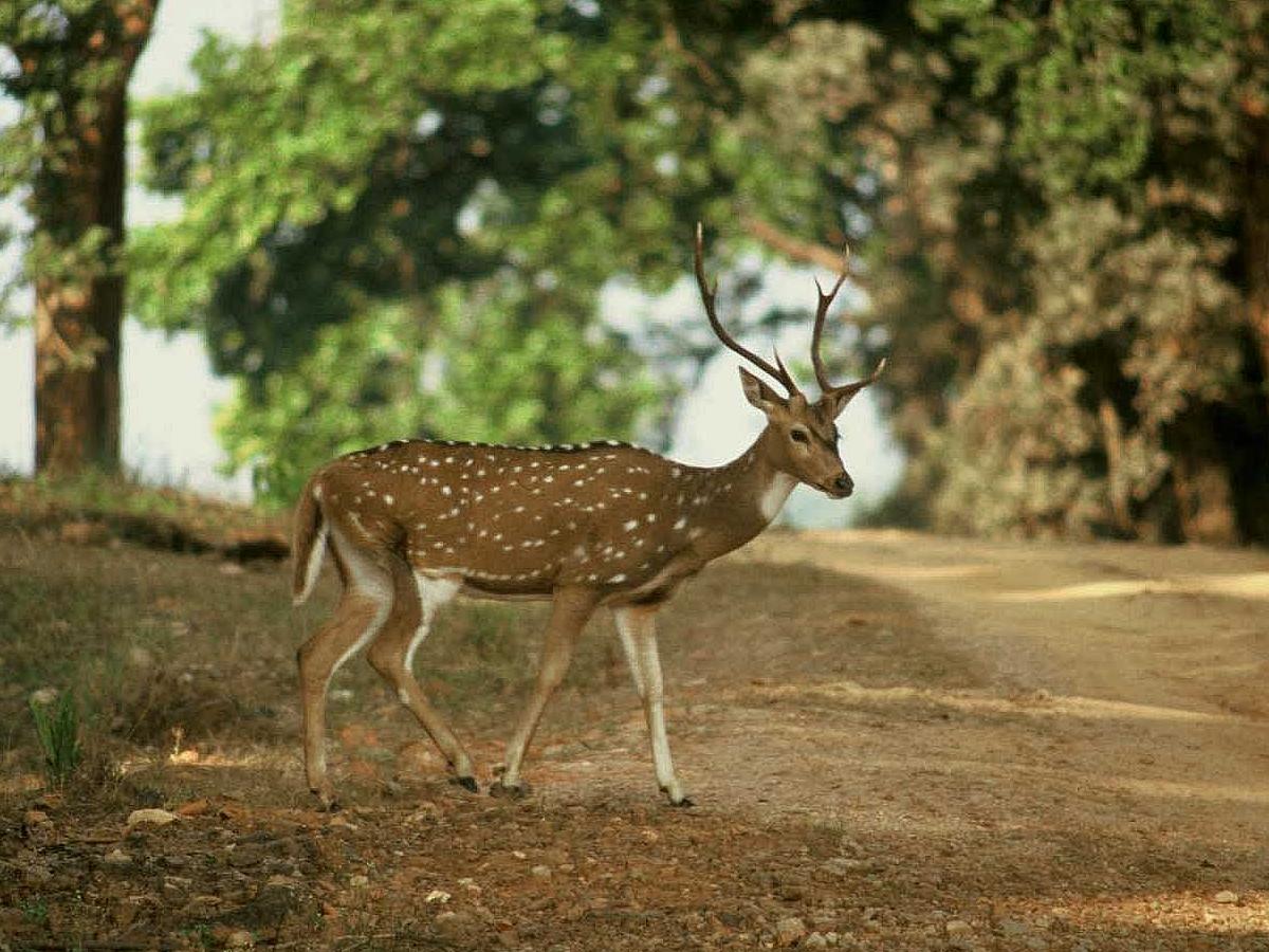
image1_cChital s are widely seen in the Sundarbans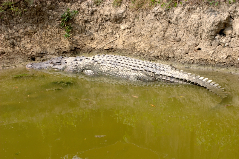
image2_ccrocodile at Sundarbans
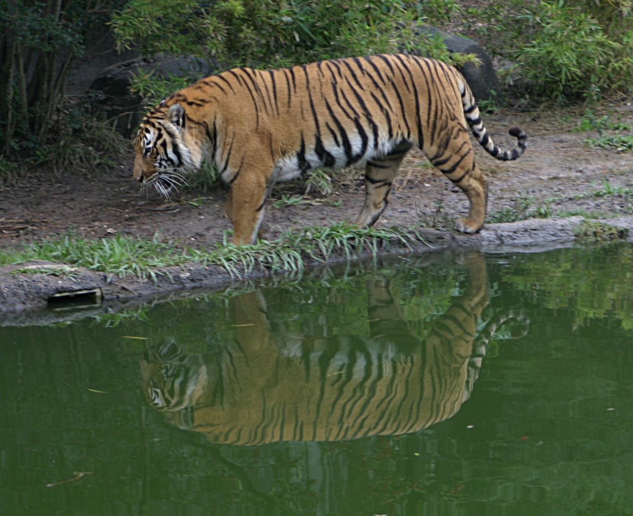
image3_cforest produce is allowed and the wildlife face few disturbances. Although it is clear that the faunal resource of Bangladesh have diminished in recent times and the Sundarbans has not been spared from this decline, the mangrove forest retains several good wildlife habitats and their associated fauna. Of these the tiger and dolphin are target species for planning wildlife management and tourism development. There are high profile and vulnerable mammals living in two contrasting environments and their statuses and management are strong indicators of the general condition of wildlife and its management. The Sundarbans are home to approximately 500 Bengal Tigers as of 2004 [ [http://www.bforest.gov.bd/highlights.php www.bforest.gov.bd/highlights.php] ] , one of the largest single populations of tigers.The Sundarbans provides a unique ecosystem and extensive habitats for wildlife. A human interface in the Sundarbans in terms of resource extraction and forest management has important effects on wildlife habitats and populations. The river terrapin ("
Batagur baska "), Indian flap-shelled turtle ("Lissemys punctata "), peacock soft-shelled turtle ("Trionyx hurum "), yellow monitor ("Varanus flavescens "), water monitor ("Varanus salvator "), Indian python ("Python molurus ") and the Bengal tiger ("Panthera tigris tigris ") are some of the resident species. Some of these species are protected by legislation, notably by the Bangladesh Wildlife (Preservation) Order, 1973 (P.O. 23 of 1973). Some species such as hog deer ("Axis porcinus "), water buffalo ("Bubalus bubalis "), swamp deer ("Cervus duvauceli "), Javan rhinoceros ("Rhinoceros sondaicus "), single horned rhiniceros ("Rhinoceros unicornis ") and the mugger crocodile ("Crocodylus palustris ") have become extinct in the Sundarbans at the beginning of the last century.Sarker, S.U. 1993. Ecology of Wildlife UNDP/FAO/BGD/85/011. Field Document N. 50 Institute of Forestry and Environmental Sciences. Chittagong, Bangladesh. 251 p.]Recent studies revealed that the Bangladesh Sundarbans support diverse biological resources including at least 120 species of commercially important fishes, 270 species of birds, 42 species of mammals, 35 reptiles and eight amphibian species. This represents a significant proportion of the species present in Bangladesh (i.e. about 30% of the reptiles, 37% the birds and 34% of the mammals) and includes a large number of species which are now extinct elsewhere in the country. [Scott, D.A. 1991. Asia and the Middle East Wetlands. M. Finlayson and M. Moser (eds.). Oxford: 151-178.] Of these wildlife, Sarker has noted that two amphibians, 14 reptiles, 25 aves and five mammals are presently endangered. The Sundarbans is a paradise for the ornithologists for watching, study and research on avifauna. [Habib, M.G. 1999. Message In: Nuruzzaman, M., I.U. Ahmed and H. Banik (eds.). The Sundarbans world heritage site: an introduction, Forest Department, Ministry of Environment and Forest, Government of the People’s Republic of Bangladesh. 12 p.]
The Sundarbans are home to approximately 500 Bengal Tigers as of 2004 [ [http://www.bforest.gov.bd/highlights.php www.bforest.gov.bd/highlights.php] ] , one of the largest single population of tigers. Tiger attacks are frequent in the Sundarbans. Between 100 and 250 people are killed per year. However, owing to various measures taken for safety, there is no report of single death since 2004 in Indian portion of the Sundarbans.
Economy
Image stack
align= right
image_size= 220px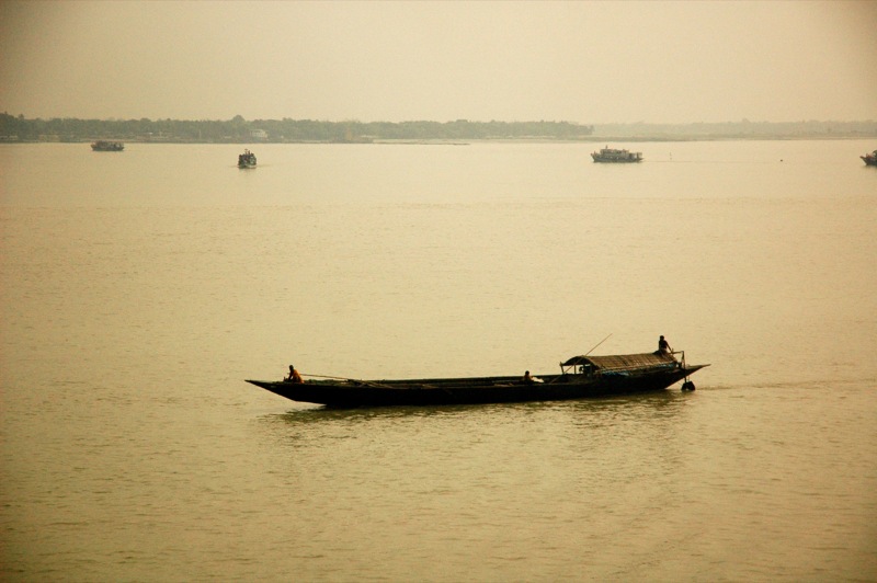
image1_cFishing boat in the Sundarbans
image2_cLogging boat in the Sundarbans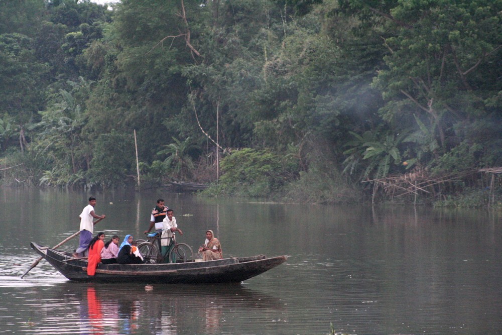
image3_cFerry boat in the SundarbansThe Sundarbans has a population of over 4 millionSubir Bhaumik, [http://news.bbc.co.uk/1/hi/world/south_asia/3102948.stm Fears rise for sinking Sundarbans] , BBC News, 2003-09-15] but much of it is mostly free of permanent human habitation.The Sundarbans play an important role in the economy of the southwestern region of Bangladesh as well as in the national economy. It is the single largest source of
forest produce in the country. The forest provides raw material for wood based industries. In addition to traditional forest produce like timber, fuelwood, pulpwood etc., large scale harvest of non wood forest products such as thatching materials, honey, bees-wax, fish, crustacean and mollusk resources of the forest takes place regularly. The vegetated tidal lands of the Sundarbans also function as an essential habitat, nutrient producer, water purifier, nutrient and sediment trap, storm barrier, shore stabilizer, energy storage unit and aesthetic attraction.The forest also has immense protective and productive functions. Constituting 51% of the total reserved forest estate of Bangladesh it contributes about 41% of total forest revenue and accounts for about 45% of all timber and fuel wood output of the country (FAO 1995). A number of industries (e.g. newsprint mill, match factory, hardboard, boat building, furniture making) are based on the raw material obtained from the Sundarbans ecosystem. Various
non-timber forest products andplantation s help generate considerable employment and income generation opportunities for at least half a million poor coastal population. Besides production functions of the forest, it provides natural protection to life and properties of the coastal population incyclone prone Bangladesh.Despite human habitations and economic exploitation of the forest, Sundarbans retained a forest closure of about 70% according to the Overseas Development Administration (ODA) of the
United Kingdom in 1985.Forest inventories reveal a decline in standing volume of the two main commercial mangrove species — sundari ("
Heritiera fomes "} and gewa ("Excoecaria agallocha"} — by 40% and 45% respectively between 1959 and 1983 (Forestal 1960 and ODA 1985). Also, despite a total ban on all killing or capture ofwildlife other than fish and someinvertebrates , there appears to be a pattern of depleted biodiversity or loss of species (notably at least six mammals and one important reptile this century), and that the "ecological quality of the original mangrove forest is declining" (IUCN 1994).anctuaries in Bangladesh
The Bangladesh part of the Sundarbans is estimated to be about 4,110 km², of which about 1,700 km² is occupied by waterbodies in the forms of river, canals and creeks of width varying from a few meters to several kilometers. The interconnected network of waterways makes almost every corner of the forest accessible by boat. The forest lies under two forest divisions, and four administrative ranges viz
Chandpai ,Sarankhola ,Khulna , andBurigoalini and has sixteen forest stations. It is further divided into fifty-five compartments and nine blocks.Citation | last = Pasha | first = Mostafa Kamal | last2 = Siddiqui | first2 = Neaz Ahmad | contribution = Sundarbans | editor-last = Islam | editor-first = Sirajul | editor-link = Sirajul Islam | title =Banglapedia : national encyclopedia of Bangladesh | publisher =Asiatic Society of Bangladesh | place =Dhaka | isbn = 9843205766 | publication-date = 2003 | contribution-url = http://banglapedia.net/HT/S_0602.HTM]A new Khulna Forest Circle to preserve the forest was created in 1993 and a Conservator of Forests has been posted. The direct administrative head of the Division is the Divisional Forest Officer who is also based at Khulna. The Divisional Forest Officer has a number of professional, subprofessional and support staff and logistic supports for the implementation of necessary management and administrative activities. The basic unit of management is the compartment. There are 55 compartments in four Forest Ranges and these are clearly demarcated mainly by natural features such as rives, canals and creeks.
There are three wildlife sanctuaries established in 1977 under the Bangladesh Wildlife (Preservation) Order, 1973 (P.O. 23 of 1973). These are:
# Sundarbans East Wildlife Sanctuary: Extends over an area of 31,227 ha. Freshwater and Sundri ("Heritiera fomes ") dominate interspersed with Gewa ("Excoecaria agallocha ") and Passur ("Xylocarpus mekongensis ") with Kankra ("Bruguiera gymnorrhiza ") occurring in areas subject to more frequent flooding. There is a understory of Shingra ("Cynometra ramiflora ") where, soils are drier and Amur ("Amoora cucullata ") in wetter areas and Goran ("Ceriops decandra ") in more saline places. Nypa palm ("Nypa fruticans ") widespread along drainage lines.
# Sundarbans South Wildlife Sanctuary: Extends over an area of 36,970 ha. There is evidently the greatest seasonal variation in salinity levels and possibly represents an area of relatively longer duration of moderate salinity where Gewa is the dominant woody species. It is often mixed with Sundri, which is able to displace in circumstances such as artificially opened canopies where Sundri does not regenerate as effectively. It is also frequently associated with a dense understory of Goran and sometimes Passur.
# Sundarbans West Wildlife Sanctuary: Extends over an area of 71,502 ha. Includes areas which support sparse Gewa and dense stands of Goran and discontinuous patches of Hantal palm ("Phoenix paludosa ") on drier ground and river banks and levees.In popular culture
The Sundarbans has been celebrated in numerous Bengali and
Indian English novels, songs, and film.The Bengali folk epic
Manasamangal mentions "Netidhopani" and has some passages set in the Sunderbans during the heroineBehula 's quest to bring her husband "Lakhindar" back to life. "Sundarbaney Arjan Sardar", a novel byShibshankar Mitra , andPadma Nadir Majhi , a novel byManik Bandopadhyay , are based on the rigors of lives of villagers and fishermen in the Sunderbans region, and are woven into the Bengali psyche to an extent. Part of the plot of Salman Rushdee'sBooker Prize winning novel, "Midnight's Children " is also set in the Sundarbans. Most of the plot of prize-winning anthropologistAmitav Ghosh 's 2004 novel, "The Hungry Tide ", is set in the Sundarbans.The Sunderbans has been the subject of numerous non-fiction books, including the "The Man-Eating Tigers of Sundarbans" by
Sy Montegomery for a young audience, which was shortlisted for theDorothy Canfield Fisher Children's Book Award ."Padma Nadir Majhi" was also made into a movie by
Goutam Ghose . Numerous documentary movies have been made about the Sunderbans, including the 2003IMAX production about theBengal Tiger -Shining Bright . The acclaimedBBC TV series Ganges documents the lives of villagers, especiallyhoney collector s, in the Sundarbans.The Sunderbans are celebrated through numerous Bengali folk songs and dances, often centered around the folk heroes, gods and goddesses specific to the Sunderbans (like
Bonbibi andDakshin Rai ) and to the Lower Gangetic Delta (likeManasa andChand Sadagar ).ee also
* [http://uk.youtube.com/watch?v=btJ7MKRB5Oo Video on Sundarbans]
*Sundarbans National Park
*Sundarbans tiger project
*Sundarbans freshwater swamp forests
*Tiger attacks in the Sundarbans
*Mukti (organization)
*Vivada Inland Waterways Limited Footnotes and references
ources
* Laskar Muqsudur Rahman, [http://www.fs.fed.us/rm/pubs/rmrs_p015_2/rmrs_p015_2_143_148.pdf The Sundarbans: A Unique Wilderness of the World] ; at [http://www.fs.fed.us/ USDA Forest Reserve] ; McCool, Stephen F.; Cole, David N.; Borrie, William T.; O’Loughlin, Jennifer, comps. 2000. Wilderness science in a time of change conference, Volume 2: Wilderness within the context of larger systems; 1999 May 23–27; Missoula, MT. Proceedings RMRS-P-15-VOL-2. Ogden, UT: U.S. Department of Agriculture, Forest Service,Rocky Mountain Research Station .
* Terminal Report, [http://www.fao.org/docrep/field/383933.htm Integrated Resource Development of the Sundarbans Reserved Forest] : Project Findings and Recommendations,Food and Agriculture Organization (acting as executing agency for theUnited Nations Development Programme ),United Nations , Rome, 1998 (prepared for the Government of Bangladesh)
* Blasco, F. (1975). "The Mangroves of India". Institut Francis de Pondichery, Travaux de las Section Scientifique et Technique, Tome XIV, Facicule 1. Pondichery, India.
* FAO (1995). "Integrated Resource Management Plan of the Sundarbans Reserved Forest - Final Report". FAO Project BGD/84/056. FAO, Rome, Italy.
* Forestal (1960). "Forest Inventory 1958-59 Sundarbans Forests." Oregon: Forestal Forestry and Engineering International Ltd, Canada.
* IUCN (1994). "Mangroves of the Sundarbans. Volume 2: Bangladesh." The IUCN Wetlands Programme. IUCN, Gland, Switzerland.
* ODA (1985). "A forest inventory of the Sundarbans, Bangladesh." Main Report. Land Resources Development Centre, Surbiton, England.
* Wahid, S.M., Alam, M.J. and Rahman, A. (2002). "Mathematical river modelling to support ecological monitoring of the largest mangrove forest of the world – the *Sundarbans". "Proceedings of First Asia-Pacific DHI software conference", 17-18 June, 2002.
* Montgomery, Sy (1995). "Spell of the Tiger: The Man-Eaters of Sundarbans". Houghton Mifflin Company, New York.
* Rivers of Life: Living with Floods in Bangladesh. M. Q. Zaman. Asian Survey, Vol. 33, No. 10 (Oct., 1993), pp. 985-996
* [http://www.springerlink.com/content/gk6ulad2cjuyp52l/ Modern sediment supply to the lower delta plain of the Ganges-Brahmaputra River in Bangladesh] . September, 2001. Geo-Marine Letters, Volume 21, Number 2. doi|10.1007/s003670100069
* Floods in Bangladesh: II. Flood Mitigation and Environmental Aspects. H. Brammer. The Geographical Journal, Vol. 156, No. 2 (Jul., 1990), pp. 158-165. doi|10.2307/635323
* [http://www.ias.ac.in/currsci/mar252003/757.pdf Environmental classification of mangrove wetlands of India] . V. Selvam. Current Science, Vol. 84, No. 6, 25 March 2003.External links
*
* [http://www.sundarbanstigerproject.info Tiger Research Project on Sundarbans Tigers]
* [http://whc.unesco.org/en/list/798 Official Citation at World Heritage website]
* [http://www.unep-wcmc.org/sites/wh/sundarb.html Another Sundarban factfile]
* [http://www.banglapedia.net/HT/S_0602.htm Sundarban in Banglapedia]
* [http://srmilan.multiply.com/journal/item/15/15 The Sundarban of Bangladesh: A Rich Biodiversity of the World’s Largest Mangrove Ecosystem]* [http://www.newyorker.com/reporting/2008/04/21/080421fa_fact_alexander The NewYorker Tigerland: A journey through the mangrove forest of Bengal]
Wikimedia Foundation. 2010.