- Malda district
-
Malda district
মালদহ জেলা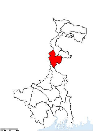
Location of Malda district in West BengalState West Bengal,  India
IndiaAdministrative division Jalpaiguri Headquarters English Bazar Area 3,733 km2 (1,441 sq mi) Population 3,997,970 (2011) Population density 1,071 /km2 (2,770 /sq mi) Urban population 240,915 Literacy 62.71 per cent[1] Sex ratio 939 Lok Sabha Constituencies Maldaha Uttar, Maldaha Dakshin Assembly Seats Habibpur, Gazole, Chanchal, Harishchandrapur, Malatipur, Ratua, Manikchak, Maldaha, English Bazar, Mothabari, Sujapur, Baisnabnagar Major highways NH 34 Official website Malda district (Bengali: মালদহ জেলা) is a district of West Bengal, India. It lies 347 km (215 miles) north of Kolkata, the state capital. Mango and silk are notable products of this district. The special variety of mango produced in this region, popularly known by the name of the district, is exported across the world and is acclaimed internationally. The folk culture of gombhira is a feature of the district, being a unique way of representation of joy and sorrow of daily life of the common people, as well as the unique medium of presentation on national and international matters.
District headquarters is English Bazar, also known as Malda, which was once the capital of Bengal. The district maintains the traditions of the past in culture and education. Old Maldah, the town which lies just east of the confluence of the Mahananda and Kalindi rivers, is part of the English Bazar urban agglomeration. The town rose to prominence as the river port of the old capital of Pandua. During the 18th century it was the seat of prosperous cotton and silk industries. It remains an important distributing centre for rice, jute, and wheat. Historical monuments include the mosque Jami' Masjid (1566) and the landmark Nimasari tower across the river. Constituted as a municipality in 1867, it has several colleges affiliated with the University of North Bengal. Rice, jute, legumes, and oilseed are the chief crops in the surrounding area. Mulberry plantations and mango orchards occupy large areas; mango trade and silk manufacture are the main economic activities. The Independence Day of Malda is 17 August 1947.
Contents
History
Pre-Gour Era
Pāṇini mentioned a city named Gourpura, which by strong reason may be identified as the city of Gouda, ruins of which are situated in this district. Examples are legion of the relics of a predecessor kingdom being used in the monuments of the successor kingdoms.
It had been within the limits of ancient Gour and Pandua (Pundrabardhana). These two cities had been the capital of Bengal in ancient and medieval ages and are equidistant, north and south, from English Bazar town (once known as Engelzavad established by the British rulers).
The boundary of Gour was changed in different ages since the 5th century BC, and its name can be found in Puranic texts. Pundranagara was the provincial capital of the Maurya Empire. Gour and Pundravardhana formed parts of the Mourya empire as is evinced from the inscriptions, Brahmi script on a seal discovered from the ruins of Mahasthangarh in the Bogra District of Bangladesh. Hiuen Tsang saw many Asokan stupas at Pundravardhana.
The inscriptions discovered in the district of undivided Dinajpur and other parts of North Bengal, along with the Allahabad pillar inscriptions of Samudragupta, clearly indicate that the whole of North Bengal as far east as Kamrup formed a part of the Gupta Empire.
After the Guptas in the beginning of 7th century AD Sasanka, the king of Karnasubarna as well as the king of Gauda ruled independently for more than three decades. From the middle of 8th century to the end of 11th century the Pala dynasty ruled Bengal, the kings were devoted to Buddhism. It was during their reign that the Jagadalla Vihara (monastery) in Barindri flourished paralleling with Nalanda, Vikramshila and Devikot.
Gour Era
The Pala empire yielded to the emergence of Sen Dynasty, the Sen rulers were Hindus, and in the habit of moving from place to place within their kingdom. During this time, Buddhism went on the defensive. It evantually disappeared from the demographic map of Bengal. At the time of Lakshman Sen Goud was known as Lakshmanabati. The Sen kings ruled Bengal till Bakhtiyar Khalji conquered Bengal in 1204 AD.
Thereafter the Muslim rule started. The name Mal Daha was coined (Mal= riches, Daha= lake). Sultan Ilyas Shah, Firuz Shah, Sikandar Shah, Raja Ganesha, Alauddin Hussain Shah and Nasiruddin Nasrat Shah are the notable rulers of medieval age. Afghan warrior Sher Shah Suri invaded Gour and was repelled by Mughal emperor Humayun. Humayun loving the mango of Gour named the place as Jannatabad (garden of heaven). Firuz Shah Tughlaq, Ghiyasuddin and Mughal army invaded Gour to suppress rebellion several time. Relics of Muslim structures are present as Firuz minar, Adina Mosque (the largest mosque of South Asia then), Qutwali gate etc. During the Mughal rule, the capital was removed to Dhaka due to a course change of the river Ganges. Muslim rule ended in 1757. Koch army invasion increased during the downfall of Gour.
Post-Gour Era
The British rule started in 1757. The English traders settled in the southern bank of the river Mahananda. Some indigo plant chambers, trade center and offices were established. William Kerry worked here. But the glorious days were gone.
This district was formed out of some portions of outlying areas of Purnia, Dinajpur and Rajshahi districts in 1813. At the time of Dr. B. Hamilton (1808–09), the present thanas of Gazole, Malda, Bamongola, and part of Habibpur were included in the district of Dinajpur and the thanas of Harischandrapur, Kharba, Ratua, Manikchak, and Kaliachak were included in the district of Purnia. In 1813, in consequence of the prevalence of serious crimes in the Kaliachak and Sahebganj thanas and also on the rivers, a Joint Magistrate and Deputy Collector was appointed at English Bazar, with jurisdiction over a number of police stations centering that place and taken from the two districts. Thus the district of Malda was born. The year 1832 saw the establishment of separate treasury and the year 1859 the posting of a full-fledged magistrate and collector.
Up to 1876, this district formed part of Rajshahi Division and between 1876 and 1905, it formed part of Bhagalpur Division. In 1905, it was again transferred to Rajshahi Division and until 1947, Malda remained in this division. During the first Partition of Bengal of 1905, this district was attached with the newly created province of Eastern Bengal and Assam. Malda has a history of Indigo movement led by Rafique Mondal. The santhals got insurgent and captured historic Adina Mosque in support of Jeetu. Again in August 1947 this district was affected by partition. Between 12–15 August 1947, the fate of the district as to which side it should go, to Pakistan or to India, was undecided because the announcement of the partition award of Sir Radcliffe did not make this point clear. During these few days the district was under a Magistrate of East Pakistan. When the details of the Radcliffe Award were published, the district came over to West Bengal on 17 August 1947. However, the sub-division of Nawabganj was severed from Malda and was given to East Pakistan as a sub-division of the Rajshahi district.
Modern Malda
Malda has been long a neglected district since independence of India, but it became a prominent place in West Bengal after the late A. B. A. Ghani Khan Chowdhury, one of the prominent personality of eastern India (b.1927-d.2006), took steps within his various capacities being minister of different portfolios from state to national ministries of India to develop Malda.
For 28 years, West Bengal was ruled by the opponents of Mr. Khan Chowdhury, who succeeded to establish a unique relation with him, and the district witnessed the fruit of this coalition in industrial sector. Sukhjeet Starch Ltd, East End Silk Ltd. and lots of other enterprises have increased. There is also a GO-NGO partnership on the card, especially artisan-based business cluster development and SME establishment is within the mission.
Geography
The latitude range is 24°40’20" N to 25°32’08" N, and the longitude range is 87°45’50" E to 88°28’10" E. The district covers an area of 3,733.66 square kilometres (1,441.6 sq mi). The total population (as of 2001 Census) was recorded as 3,290,160.
Malda is called the gateway of North Bengal. It was once the capital of Gour-Banga with its 3,733 square kilometres (1,441 sq mi) lay of the land classified into Tal, Diara, and Barind.
To the south is Murshidabad district, to the north are North Dinajpur district and South Dinajpur district. To the east is the international border with Bangladesh. To the west is Santhal Parganas of Jharkhand and Purnea of Bihar
- Erosion
Malda region is washed by the waves of the rivers Ganges, Mahananda, Fulahar and Kalindri. A 1998 flood and recent erosion have caused trouble. Manikchak suffers most.
Malda City
Main article: MaldaMalda city, the district headquarters which lends its name to the district, during its early days grew up only near the side of the river Mahananda, and now the place is known as Phulbari. Some of the oldest houses can be found here. The city started to grow since 1925-1930. Now nearly a half-million people live in this city, and it is one of the biggest cities of West Bengal. It is a part of the former Gour. The town is recognized as the English Bazaar municipality. Its notable railway station is named as Malda Town.
Economy
In 2006 the Ministry of Panchayati Raj named Malda one of the country's 250 most backward districts (out of a total of 640).[2] It is one of the eleven districts in West Bengal currently receiving funds from the Backward Regions Grant Fund Programme (BRGF).[2]
Divisions
Administrative Subdivisions
The district comprises two subdivisions: Chanchal and Malda Sadar. Chanchal consists of six community development blocks: Chanchal–I, Chanchal–II, Ratua–I, Ratua–II, Harishchandrapur–I and Harishchandrapur–II. Malda Sadar subdivision consists of Old Maldah municipality, English Bazar municipality and nine community development blocks: English Bazar, Gazole, Habibpur, Kaliachak–I, Kaliachak–II, Kaliachak–III, Manickchak, Old Maldah and Bamangola.[3] English Bazar is the district headquarters. There are 11 police stations,[4] 15 development blocks, 2 municipalities, 146 gram panchayats and 3,701 villages in this district.[3][5]
Other than municipality areas, each subdivision contains community development blocs, which in turn, are divided into rural areas and census towns.[6] In total there are 10 urban units, 2 municipalities and 3 census towns. English Bazar and Old Maldah form an urban agglomeration.
Chanchal subdivision
- Chanchal I (Community development block) consists of rural areas only (8 gram panchayats).
- Chanchal II (Community development block) consists of rural areas only (7 gram panchayats).
- Ratua I (Community development block) consists of rural areas only (10 gram panchayats).
- Ratua II (Community development block) consists of rural areas only (8 gram panchayats).
- Harishchandrapur I (Community development block) consists of rural areas only (7 gram panchayats).
- Harishchandrapur II (Community development block) consists of rural areas only (9 gram panchayats).
Malda Sadar subdivision
- English Bazar: municipality
- [[Old Maldah]town]: municipality
- English Bazar (Community development block) consists of rural areas only (11 gram panchayats).
- Gazole (Community development block) consists of rural areas only (15 gram panchayats).
- Habibpur, Malda (Community development block) consists of rural areas (11 gram panchayats) and three census towns: Kachu Pukur, Kendua and Aiho.
- Kaliachak I (Community development block) consists of rural areas only (14 gram panchayats).
- Kaliachak II (Community development block) consists of rural areas only (9 gram panchayats).
- Kaliachak III (Community development block) consists of rural areas only (14 gram panchayats).
- Manikchak (Community development block) consists of rural areas only (11 gram panchayats).
- Old Malda (Community development block) consists of rural areas only (6 gram panchayats).
- Bamangola (Community development block) consists of rural areas only (6 gram panchayats).
Demographics
According to the 2011 census Malda district has a population of 3,997,970,[7] roughly equal to the nation of Liberia[8] or the US state of Oregon.[9] This gives it a ranking of 58th in India (out of a total of 640).[7] The district has a population density of 1,071 inhabitants per square kilometre (2,770 /sq mi) .[7] Its population growth rate over the decade 2001-2011 was 21.5 %.[7] Maldah has a sex ratio of 939 females for every 1000 males,[7] and a literacy rate of 62.71 %.[7]
Nearly 32,90,160 people live in Malda. Malda has a large diversity of demographics. Various classes and tribes like Polia, Shersabadia, Khotta, Panjhra, Santhals live here. Northern part has dominantly Hindu population. Tribesman and Christian people also live here. Old Maldah has a number of Shikh population who suffered in the 1984 anti-Sikh riots.
Some Muslim-concentrated areas were transferred to Pakistan. Now South Malda boasts of a large number of Muslim population. Sujapur Idgah is one of the largest in India.
{{bar box |title=Religion in Malda District
|titlebar=#F6F6F6 |left1=Religion |right1=Percent |float=left |bars= {{bar percent|Islam|green|49.72}} {{bar percent|Hinduism|orange|49.28}} {{bar percent|Others|blue|1}}
Some local forms of Bengali, Maithili, Hindi and Urdu language are spoken along with original forms. Some regional languages are Kamtapuri, Shershahabadia, Santali, Khotta, etc.
Culture
Malda has special cultural sorts like Gombhira, Alkap,kabigan etc. Major festivals and cultural fairs are
- Durga puja
- Id-ul-Fitr
- Id-uz-Zoha
- Kali Puja
- Guru Nanak Jayanti, Especially in Old Maldah
- X-mas
Fairs
- Ramkeli FairGour
- Gazole Utsab
- Kartik puja Fair
- Charu Babu Mela
- Charak Fair
- Piran-e-Pir fair
Book fair and Expo are organized yearly.
Places of interset
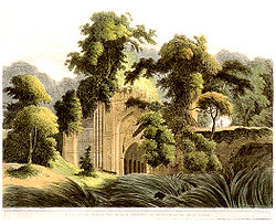 Early 19th century lithograph of the Muslim ruins of Dakhil Darwaza at Gour
- Adina Relics
- Adina Mosque
- Gol ghar
- Eklakhi mosque
- Adina deer park
- Relics of Gour
- Firoz minar
- Chika Masjid
- Qutwali Gate
- 12-gated mosque
- Qudm-e-Rasul, shrine believed to contain footprint of the Prophet
- Nimasarai Tower
- Jami Masjid
- Pandua Shrine
- Piran-e-Pir Shrine.
- Lost monastery of Jagjivanpur.
- Temple of Ramakrishna Mission.
- Chanchal palace
- Aquatic Bengal
Notable personalities
- See List of rulers of Bengal
- A. B. A. Ghani Khan Chowdhury, former railways minister of India (1982–84)
- Asim Dasgupta, former finance minister of West Bengal, who studied in Malda Zilla School
- Shibram Chakraborty, Bengali satirist
Flora and fauna
The flora of Malda district is merely a small portion of that extending from Kose to the Brahmapurtra. Alteration of beels and village shrubbery with the drier jungle of the Barind region, where the ground is not occupied by the usual crops, it is covered by an abundant natural vegetation excepting the sandy beds of rivers. Old river beds, ponds, marshy land and other watery regions have a copious vegetation of vallisneria and other plants. The areas which are subject to frequent inundation usually cover themselves with seedy grasses, and in marshy parts the Rosainvolucrata is plentiful. Some portions of the Barind area are covered by jungles, which consist chiefly of thorny scrub-bush jungles mixed with Pipal, Bat, Simul and Pakur trees and Nepal Bamboos. Species of thorny bamboos are also seen in Pandua areas near villages and embankment areas of Gour thickets or shrubberies, ordinary Neem, Jackfruit trees, tamarind, bamboo, pipul and mango trees are seen in plenty. The soil of the western region of the district is particularly suited to the growth of mulberry and mango, for the production of both of which Malda has become famous.
Though about a century ago, Malda was a well-known place for the unusual quantity of large game animals, at present the district has lost its charm in this respect. Earlier, the breeding grounds of the animals were the thorny jungles of the Barind area and jungles covering the Gour and Pandua ruins. Malda was often described as the "best sporting ground of north Bengal". Many European travellers witnessed crocodiles on wetlands of Gour. In 1919 the last-known tiger, and in 1965 the last leopard of Malda was killed.
But the jungles have mostly been cleared and their inhabitants exterminated by the Santals and Paharias, who have crossed the Ganges in large number to settle in Barind and other areas. It is a time when the people become aware of the dangers of ecological imbalance.
The rivers, beels, and ponds of Malda produce considerable quantities of various categories of fishes, inclding Rohu, Katla, Chital, Boal, Magur, Shol, Hilisha, Pabda and varieties of crabs, prawns, turtles, etc. Pisciculture has been undertaken under various projects according to modern scientific methods.
Education
Though Malda is one of the most educated districts of West Bengal, it contains most of the élite schools of the state. Malda Zilla School, Ramakrishna Mission Vivekananda Vidyamandir, The Barlow Girls High School, A C Institution, Lalitmohan, Malda Town High School, C.C.Girls High School, St Xavier (English medium), St Mary School (English medium), Jingle Bell School (An English Medium preparatory school),Usha Martin School(English medium), Holy Child English Academy and North Point English Academy are also some of the most reputed schools of the district. Malda Zilla School is the oldest school in town and also one of the oldest schools in West Bengal. It was established in 1858 on recommendation of the Hunter commission after the mutiny. Malda College was also in the top league among North Bengal University affiliated colleges. Now it has its own university, Gour Banga University with affiliated colleges in the district and neighboring South and North Dinajpur. Malda town also has an engineering college and a few private technical institutions, mostly for computer-related professional courses. For a long time, proposals have been on the table for a medical college in Malda.
Among important persons of Malda District: Benoy Sarkar who was Professor of Calcutta University and former student of Malda Zilla School. Ramesh Chandra Ghosh MABL was a former student of Malda Zilla School and Lawyer practised at Chapai Nawabganj and Malda. He was politician and imprisoned by British during independence movement. He was a Colleague of Netaji Subhas Chandra Bose. His house "Shital Kutir" stands in Mahesmati Rajmahal Road of the Town. Professor Ajit Kumar Ghosh was principal of Howrah Girls College(Bejoy Krishna Girls College)near Calcutta. He was secretary of "Malda in Calcutta Society" with Benoy Sarker as Chaiman. He wrote a book "Federation of Half of Europe" published in 1948 based on his lecture at Asiatic Society of Calcutta in 1947. Other distinguished sons of Malda District are: Dr Ranajit Ghosh well-known medical practitioner, Professor Santosh Ghosh M Arch(USA) became chief architect of Calcutta and Dr Jayanti Kumar Ghosh, medical doctor worked in British National Health Service and was Principal in General Medical Practice of Bondicar Medical Group of Blyth Northumberland UK and Fellow of The Royal Society of Medicine London and now settled in England in UK.
Also there is an educational consultancy Global Education Service, which provides free services to students including free career counselling, admission guidance, scholarship guidance, university selection, academic pathway planning, visa assistance, finance guidance, travel assistance, Forex assistance, etc.
Also, there are the trams plying through the roads in Malda, during the British period, but was gradually removed for the sake of convenience. The population of the people consists mainly of Hindus, and some minorities of Muslims, Christians, etc.
See also
- List of rulers of Bengal
- History of Bengal
- Pala dynasty
- Gour
References
- ^ "District-specific Literates and Literacy Rates, 2001". Registrar General, India, Ministry of Home Affairs. http://www.educationforallinindia.com/page157.html. Retrieved 2010-10-10.
- ^ a b Ministry of Panchayati Raj (September 8, 2009). "A Note on the Backward Regions Grant Fund Programme". National Institute of Rural Development. http://www.nird.org.in/brgf/doc/brgf_BackgroundNote.pdf. Retrieved September 27, 2011.
- ^ a b "Directory of District, Sub division, Panchayat Samiti/ Block and Gram Panchayats in West Bengal, March 2008". West Bengal. National Informatics Centre, India. 2008-03-19. http://wbdemo5.nic.in/writereaddata/Directoryof_District_Block_GPs(RevisedMarch-2008).doc. Retrieved 2008-11-10.
- ^ "Census of India 2001, Final Population Totals, West Bengal, Rural Frame". West Bengal. Directorate of census operations. http://web.cmc.net.in/wbcensus/DataTables/01/Table2_2.htm. Retrieved 2008-11-10.
- ^ "District Profile". Official website of the Malda district. http://malda.nic.in/Disprof.htm. Retrieved 2008-11-10.
- ^ "Population, Decadal Growth Rate, Density and General Sex Ratio by Residence and Sex, West Bengal/ District/ Sub District, 1991 and 2001". West Bengal. Directorate of census operations. http://web.cmc.net.in/wbcensus/DataTables/02/Table4_6.htm. Retrieved 2008-11-10.
- ^ a b c d e f "District Census 2011". Census2011.co.in. 2011. http://www.census2011.co.in/district.php. Retrieved 2011-09-30.
- ^ US Directorate of Intelligence. "Country Comparison:Population". https://www.cia.gov/library/publications/the-world-factbook/rankorder/2119rank.html. Retrieved 2011-10-01. "Liberia 3,786,764 July 2011 est."
- ^ "2010 Resident Population Data". U. S. Census Bureau. http://2010.census.gov/2010census/data/apportionment-pop-text.php. Retrieved 2011-09-30. "Oregon 3,831,074"
External links

Katihar district, Bihar North Dinajpur district South Dinajpur district Sahebganj district, Jharkhand 
Bangladesh  Malda district

Murshidabad district Cities and towns in Malda district Chanchal subdivision Malda Sadar subdivision Related topics Malda topics • Villages in Malda district • People from Malda districtCities and towns
in other districtsBankura · Bardhaman · Birbhum · Cooch Behar · Dakshin Dinajpur · Darjeeling · Hooghly · Howrah · Jalpaiguri · Murshidabad · Nadia · North 24 Parganas · Paschim Medinipur · Purba Medinipur · Purulia · South 24 Parganas · Uttar DinajpurMalda district topics General History Subdivisions Locations
other than cities and townsMunicipalities Community development blocks Malda Sadar subdivision Bamangola • English Bazar • Gazole • Habibpur • Kaliachak I • Kaliachak II • Kaliachak III • Manikchak • Old Malda Chanchal subdivision Chanchal I • Chanchal II • Harishchandrapur I • Harishchandrapur II • Ratua I • Ratua IIRivers Transport NH 34 • Eastern Railway (India)Lok Sabha constituencies Vidhan Sabha constituencies Former Vidhan Sabha constituencies Kaliachak • Kharba • AraidangaSee also Other districts in West Bengal Bankura • Bardhaman • Birbhum • Cooch Behar • Dakshin Dinajpur • Darjeeling • Hooghly • Howrah • Jalpaiguri • Kolkata • Murshidabad • Nadia • North 24 Parganas • Paschim Medinipur • Purba Medinipur • Purulia • South 24 Parganas • Uttar DinajpurSurrounding areas outside West Bengal Bihar Cities and towns in Purnia division • Purnia division topics Jharkhand Cities and towns in Santhal Parganas • Santhal Pargana division topics Bangladesh Rajshahi DivisionMinority Concentrated Districts in India Andaman & Nicobar Islands Arunachal Pradesh Assam Barpeta · Bongaigaon · Cachar · Darrang · Dima Hasao · Dhubri · Goalpara · Hailakandi · Kamrup · Karimganj · Kokrajhar · Marigaon · Nagaon
Bihar Delhi Haryana Jammu & Kashmir Jharkhand Karnataka Kerala Madhya Pradesh Maharashtra Manipur Meghalaya Mizoram Orissa Uttar Pradesh Baghpat · Bahraich · Balrampur · Barabanki · Bareilly · Bijnor · Budaun · Bulandshahar · Ghaziabad · Jyotiba Phule Nagar · Kheri · Lucknow · Meerut · Moradabad · Muzaffarnagar · Pilibhit · Rampur · Saharanpur · Shahjahanpur · Shravasti · Siddharth NagarUttarakhand West Bengal Bardhaman · Birbhum · Cooch Behar · Dakshin Dinajpur · Howrah · Kolkata · Malda · Murshidabad · Nadia · North 24 Parganas · South 24 Parganas · Uttar DinajpurCategories:- Districts of West Bengal
- Malda district
- Minority Concentrated Districts in India


Wikimedia Foundation. 2010.