- Mamit district
-
This article is about the district. For its eponymous headquarters, see Mamit.
Mamit district 
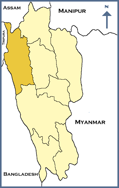
Location of Mamit district in MizoramState Mizoram,  India
IndiaHeadquarters Mamit Area 3,026 km2 (1,168 sq mi) Population 62,313 (2001) Population density 21 /km2 (54 /sq mi) Lok Sabha Constituencies Mizoram Assembly Seats 3 Official website Mamit district is one of the 8 districts of Mizoram state in India.
Contents
Geography
The district is bounded on the north by Hailakandi district of Assam state, on the west by North Tripura district of Tripura state and Bangladesh, on the south by Lunglei district and on the east by Kolasib and Aizawl districts. The district occupies an area of 3025.75 km². Mamit town is the administrative headquarters of the district.
Divisions
The district has 4 R.D. Blocks, Mamit, Reiek, West Phaileng and Zawlnuam. The district has 3 legislative assembly constituencies. These are Hachhek, Dampa and Mamit.
Demographics
According to the 2011 census Mamit district has a population of 85,757 ,[1] roughly equal to the nation of Andorra.[2] This gives it a ranking of 619th in India (out of a total of 640).[1] The district has a population density of 28 inhabitants per square kilometre (73 /sq mi) .[1] Its population growth rate over the decade 2001-2011 was 36.59 %.[1] Mamit has a sex ratio of 924 females for every 1000 males,[1] and a literacy rate of 85.96 %.[1]
Flora and fauna
In 1985 Mamit district became home to Dampa Tiger Reserve, which has an area of 500 km².[3]
References
- ^ a b c d e f "District Census 2011". Census2011.co.in. 2011. http://www.census2011.co.in/district.php. Retrieved 2011-09-30.
- ^ US Directorate of Intelligence. "Country Comparison:Population". https://www.cia.gov/library/publications/the-world-factbook/rankorder/2119rank.html. Retrieved 2011-10-01. "198 Andorra 84,825 July 2011 est."
- ^ Indian Ministry of Forests and Environment. "Protected areas: Mizoram. certificate". http://oldwww.wii.gov.in/envis/envis_pa_network/index.htm. Retrieved September 25, 2011.
External links

North Tripura district, Tripura Karimganj district, Assam
Hailakandi district, AssamKolasib district 
Aizawl district  Mamit district

Bangladesh Lunglei district Districts of Mizoram Minority Concentrated Districts in India Andaman & Nicobar Islands Arunachal Pradesh Assam Barpeta · Bongaigaon · Cachar · Darrang · Dima Hasao · Dhubri · Goalpara · Hailakandi · Kamrup · Karimganj · Kokrajhar · Marigaon · Nagaon
Bihar Delhi Haryana Jammu & Kashmir Jharkhand Karnataka Kerala Madhya Pradesh Maharashtra Manipur Meghalaya Mizoram Lawngtlai · MamitOrissa Uttar Pradesh Baghpat · Bahraich · Balrampur · Barabanki · Bareilly · Bijnor · Budaun · Bulandshahar · Ghaziabad · Jyotiba Phule Nagar · Kheri · Lucknow · Meerut · Moradabad · Muzaffarnagar · Pilibhit · Rampur · Saharanpur · Shahjahanpur · Shravasti · Siddharth NagarUttarakhand West Bengal Bardhaman · Birbhum · Cooch Behar · Dakshin Dinajpur · Howrah · Kolkata · Malda · Murshidabad · Nadia · North 24 Parganas · South 24 Parganas · Uttar Dinajpur
Categories:- Districts of Mizoram
- Mamit district
- Minority Concentrated Districts in India
Wikimedia Foundation. 2010.