- List of districts of Mizoram
-
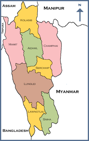
The Indian state of Mizoram is divided into 8 districts.
Contents
History
When Mizoram became a Union Territory on 21 January 1972, it was divided into three districts: Aizwal, Lunglei and Chhimtuipui. Later five more districts were carved out of the erstwhile three districts.
Administrative structure
A district of Mizoram is headed by a Deputy Commissioner who is in charge of the administration in that particular district. He has to perform triple functions as he holds three positions as the Deputy Commissioner, the District Magistrate and the District Collector.As a Deputy Commissioner he is the executive head of the district.The District Magistrate is responsible for maintaining the law and order situation in the district.As the Collector he is the Chief Revenue Officer of the district who is responsible for revenue collection and recovery.
A Superintendent of Police (SP) controls the police administration of each district.
A district is divided into one or more subdivisions, further divided into tehsils and blocks.
Districts
Code[1] District Headquarters Established Subdivisions Area Population As of 2001[update] Population Density Map AI Aizawl Aizawl 3,577 km2 (1,381 sq mi) 339,812 95 /km2 (250 /sq mi) CH Champhai Champhai 3,168 km2 (1,223 sq mi) 101,389 32 /km2 (83 /sq mi) KO Kolasib Kolasib 1,386 km2 (535 sq mi) 60,977 44 /km2 (110 /sq mi) LA Lawngtlai Lawngtlai 2,519 km2 (973 sq mi) 73,050 29 /km2 (75 /sq mi) LU Lunglei Lunglei 4,572 km2 (1,765 sq mi) 137,155 30 /km2 (78 /sq mi) MA Mamit Mamit 2,967 km2 (1,146 sq mi) 62,313 21 /km2 (54 /sq mi) SA Saiha Saiha 1,414 km2 (546 sq mi) 60,823 43 /km2 (110 /sq mi) SE Serchhip Serchhip 1,424 km2 (550 sq mi) 55,539 39 /km2 (100 /sq mi) Total -- -- 21,081 km2 (8,139 sq mi) 888,573 42 /km2 (110 /sq mi) References
- ^ "NIC Policy on format of e-mail Address: Appendix (2): Districts Abbreviations as per ISO 3166-2". Ministry Of Communications and Information Technology, Government of India. 2004-08-18. pp. 5–10. https://www.mail.nic.in/docs/MailService_e-mail_address_Policy_WithCodes.pdf. Retrieved 2008-11-24.
External links
Districts of States of India States Andhra Pradesh · Arunachal Pradesh · Assam · Bihar · Chhattisgarh · Goa · Gujarat · Haryana · Himachal Pradesh · Jammu and Kashmir · Jharkhand · Karnataka · Kerala · Madhya Pradesh · Maharashtra · Manipur · Meghalaya · Mizoram · Nagaland · Orissa · Punjab · Rajasthan · Sikkim · Tamil Nadu · Tripura · Uttar Pradesh · Uttarakhand · West Bengal
Union Territories Andaman and Nicobar Islands · Chandigarh · Dadra and Nagar Haveli · National Capital Territory of Delhi · Daman and Diu · Lakshadweep · PuducherryRelated topics List of states and territories of India · District collector · Sub-Divisional Magistrate · Community Development Block · Block Development Officer · Gram panchayatCategories:- Districts of Mizoram
- Mizoram-related lists

Wikimedia Foundation. 2010.