- Districts of Arunachal Pradesh
-
Contents
History
On December 1, 1965 the erstwhile North-East Frontier Agency was divided in to five districts:
- Kameng district
- Subansiri district
- Siang district
- Lohit district
- Tirap district
On May 13, 1980, Subansiri district was bifurcated into two districts: Lower Subansiri district and Upper Subansiri district. Upper Subansiri district comprised the area occupied by the erstwhile Daporijo sub-division and Lower Subansiri district comprised the rest of the area occupied by the erstwhile Subansiri district.
On June 1, 1980 the erstwhile Lohit district was divided into two districts: Lohit district and Dibang Valley district. On the same day, Siang district was bifurcated in to two districts: East Siang district and West Siang district and Sepla and Bomdila sub-divisions of the Kameng district were transformed in to East Kameng district and West Kameng district respectively.
On October 6, 1984 Tawang district was separated from East Kameng district. In 1987, the ersthwile Tirap district was divided in to two districts: Tirap district and Changlang district. On September 22, 1992 the erstwhile Lower Subansiri district was again bufurcated in to Lower Subansiri district and Papum Pare district. In June, 2000 Kurung Kumey district was carved out from the erstwhile Lower Subansiri district. On December 16, 2001 Dibang Valley district was bifurcated in to Upper Dibang Valley district and Lower Dibang Valley district. On February 16, 2004 Anjaw district was carved out from the erstwhile Lohit district.
Administrative set-up
The districts of Arunachal Pradesh state are administrative geographical units, each headed by a deputy commissioner, an officer belonging to the Indian Administrative Service.
Districts
Presently, Arunachal Pradesh state comprises 16 districts. Most of them are inhabited by various tribal groups. These are[1]:
Code District Headquarters Population (2011)[2] Area (km²) Density (/km²) Map AJ Anjaw Hawai 21,089 3,234 6 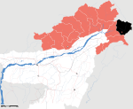
CH Changlang Changlang 147,951 4,662 27 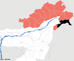
EK East Kameng Seppa 78,413 4,134 14 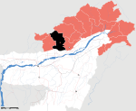
ES East Siang Pasighat 99,019 4,005 22 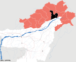
EL Lohit Tezu 145,538 2,402 13 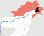
LB Lower Subansiri Ziro 82,839 10,135 10 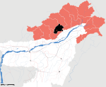
PA Papum Pare Yupia 176,385 2,875 42 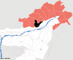
TA Tawang Tawang Town 49,950 2,085 19 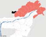
TI Tirap Khonsa 111,997 2,362 42 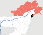
UD Lower Dibang Valley Roing 53,986 4 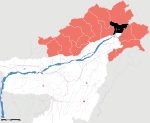
US Upper Siang Yingkiong 33,146 6,188 5 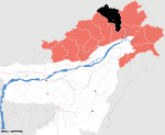
UB Upper Subansiri Daporijo 83,205 7,032 8 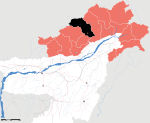
WK West Kameng Bomdila 87,013 7,422 10 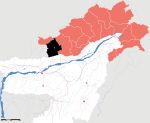
WS West Siang Along 112,272 8,325 12 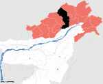
Upper Dibang Valley Anini 7,948 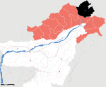
Kurung Kumey Koloriang 89,717 7 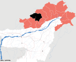
Notes
- ^ "At a glance". Government of Arunachal Pradesh website. http://arunachalpradesh.nic.in/glance.htm.
- ^ "District Census 2011". Census2011.co.in. http://www.census2011.co.in/district.php.
Districts of States of India States Andhra Pradesh · Arunachal Pradesh · Assam · Bihar · Chhattisgarh · Goa · Gujarat · Haryana · Himachal Pradesh · Jammu and Kashmir · Jharkhand · Karnataka · Kerala · Madhya Pradesh · Maharashtra · Manipur · Meghalaya · Mizoram · Nagaland · Orissa · Punjab · Rajasthan · Sikkim · Tamil Nadu · Tripura · Uttar Pradesh · Uttarakhand · West Bengal
Union Territories Andaman and Nicobar Islands · Chandigarh · Dadra and Nagar Haveli · National Capital Territory of Delhi · Daman and Diu · Lakshadweep · PuducherryRelated topics List of states and territories of India · District collector · Sub-Divisional Magistrate · Community Development Block · Block Development Officer · Gram panchayatCategories:- Arunachal Pradesh
- Arunachal Pradesh-related lists


Wikimedia Foundation. 2010.