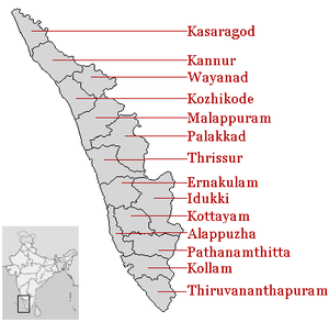
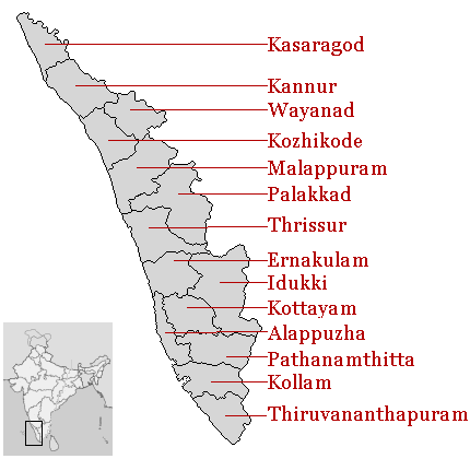
- List of districts in Kerala
-
The Indian state of Kerala borders with the states of Tamil Nadu on the south and east, Karnataka on the north and the Arabian Sea coastline on the west. The Western Ghats, bordering the eastern boundary of the State, form an almost continuous mountain wall, except near Palakkad where there is a natural mountain pass known as the Palakkad Gap.[1] When the independent India amalgamated small states together Travancore and Cochin states were integrated to form Travancore-Cochin state on 1 July 1949. However, Malabar remained under the Madras province. The States Reorganisation Act of 1 November 1956 elevated Kerala to statehood.[2]
The state of Kerala is divided into 14 revenue districts. On the basis of geographical, historical and cultural similarities, the districts are generally grouped into Malabar (Northern Kerala) (Kasaragod, Kannur, Wayanad, Kozhikkode, Malappuram); Kochi Region (Central Kerala) (Palakkad, Thrissur, Eranakulam); and Travancore (South Kerala) (Thiruvananthapuram, Kollam, Alappuzha, Pathanamthitta, Kottayam, Idukki).[3] Such a regional division occurred being part of historical Kingdoms of Kochi, Travancore and British Province of Malabar. The Travancore region is again divided into 3 zones as Northern Travancore (Hill Range) (Pathanamthitta and Idukki), Central Travancore (Central Range) (Alappuzha and Kottayam) and Southern Travancore (South Range) (Thiruvananthapuram and Kollam). Almost all of the districts in Kerala have the same name as the important town or city in the district, the exception being Wayanad district. The 14 districts are further divided into 62 taluks, 999 revenue villages and 1007 Gram panchayats. Some of the districts and their towns were renamed in 1990 like Thiruvananthapuram (formerly known as Trivandrum), Kollam (Quilon), Alappuzha (Alleppey),[4][5] Thrissur (Trichur or Thirushivaperur), Palakkad (Palghat), Kozhikode (Calicut) and Kannur (Cannanore).
Contents
Administrative structure
Kerala State has been divided into 14 districts, 21 revenue divisions, 14 District Panchayats, 63 taluks, 152 CD blocks, 1466 revenue villages, 999 Gram panchayats, 5 corporations and 60 municipalities.[6]
A district is governed by a District Collector, who is an officer from Indian Administrative Service (IAS) of Kerala cadre and is appointed by the State Government of Kerala. Functionally the district administration is carried on through the various Departments of the State Government each of which has an office of its own the district level. The District Collector is the executive leader of the district administration and the District Officers of the various Departments in the district render technical advice to him in the discharge of his duties. The District Collector is a key functionary of Government having large powers and responsibilities. He has a dual role to both as the agent of the Government of the state and also as the representative of the people in the district. He is also responsible for the maintenance of the law and order of the district.[7]
Other than urban units such as town municipalities and rural units called Gram panchayats, other government administrative subdivisions includes taluks and 'community development blocks' (also known as CD blocks or blocks). A taluk consists of urban units such as census towns and rural units called gram panchayats. The Tahsildar in charge of each taluk is primarily the Revenue Official responsible for the collection of revenue of the taluk, but he is also expected to be in direct contact with the people at all levels and to have first hand knowledge of the conditions of every village under his jurisdiction. The Tahsildar is assisted in each village by village officers and village assistants.[8] A block also consists of such as census towns and Gram panchayats. A block is administered by a Block Development Officer (BDO), who is appointed by the Government of Kerala. A gram panchayat, which consists of a group of villages, is administered by a village council headed by a Gram Panchayat President.
A District Superintendent of Police, better known as a Superintendent of Police, heads the District Police organization of Kerala Police. This is as per the Police Act of 1861, which is applicable to the whole of India.[9] The Superintendents of Police are officers of the Indian Police Service.[10] For every subdivision, there is a Subdivision Police, headed by a Police officer of the rank of Assistant Superintendent of Police or Deputy Superintendent of Police.[11] Under subdivisions, there are Police Circles, each headed by an Inspector of Police.[11] A Police Circle consists of Police Stations, each headed by an Inspector of Police, or in case of rural areas, by a Sub-Inspector of Police.[11]
The Kerala High Court has the jurisdiction of the state of Kerala. Each of the districts has a District Court.
History
Alleppey district was carved out of erstwhile Kottayam and Kollam (Quilon) districts on 17 August 1957. The name of the district Alleppey was changed as ‘Alappuzha’ in 1990.[4] In 1982, Pathanamthitta district was newly constituted taking portions from the then Alappuzha, Kollam and Idukki districts. The areas transferred from the erstwhile Alappuzha district to Pathanamthitta district are Thiruvalla taluk as a whole and part of Chengannur and Mavelikkara Taluks.[4]
Alphabetical listing
Code[12] District Headquarters[13] Established[14] Subdivisions Population As of 2011[update][13] Area(As 2001)[13] Population Density(As 2001) AL Alappuzha Alappuzha 7 Aug 1957[4] - 6 Taluks[4]
- Ambalapuzha
- Chengannur
- Cherthala
- Karthikappally
- Kuttanad
- Mavelikkara
2121943 1,414 km2 (546 sq mi) 1,489 /km2 (3,860 /sq mi) ER Ernakulam Kakkanad 1 Apr 1958[15] - 7 Taluks[16]
- Aluva
- Kanayannur
- Kochi
- Kothamangalam
- Kunnathunad
- Muvattupuzha
- Paravur
3279860 2,951 km2 (1,139 sq mi) 1,050 /km2 (2,700 /sq mi) ID Idukki Painavu 26 Jan 1972[17][18] - 4 Taluks
- Devikulam
- Peerumade
- Thodupuzha
- Udumbanchola
1107453 4,479 km2 (1,729 sq mi) 252 /km2 (650 /sq mi) KL Kollam Kollam 1 Nov 1956[19]
( )[20]- 5 Taluks[8]
- Karunagappally
- Kollam
- Kottarakkara
- Kunnathoor
- Pathanapuram
26,29,703 2,498 km2 (964 sq mi) 1,034 /km2 (2,680 /sq mi) KN Kannur Kannur 1 Jan 1957[21] - 3 Taluks[21]
- Kannur
- Thalassery
- Thalipparamba
2525637 2,966 km2 (1,145 sq mi) 813 /km2 (2,110 /sq mi) KS Kasaragod Kasaragod 24 May 1984[22][23] - 2 Taluks[24]
- Kasaragod
- Hosdurg
1302600 1,992 km2 (769 sq mi) 604 /km2 (1,560 /sq mi) KT Kottayam Kottayam 1 Nov 1956[25]
( )[20]- 5 Taluks[26]
- Changanasserry
- Kanjirappally
- Kottayam
- Meenachil
- Vaikom
1979384 2,203 km2 (851 sq mi) 886 /km2 (2,290 /sq mi) KZ Kozhikode Kozhikode 1 Jan 1957[27] 3089543 2,345 km2 (905 sq mi) 1,228 /km2 (3,180 /sq mi) MA Malappuram Malappuram 16 Jun 1969[29] - 6 Taluks[29]
- Eranad
- Nilambur
- Perinthalmanna
- Ponnani
- Tirur
- Tirurangadi
4110956 3,550 km2 (1,370 sq mi) 1,022 /km2 (2,650 /sq mi) PL Palakkad Palakkad 1 Jan 1957[30] - 5 Taluks[31]
- Alathur
- Chittur
- Mannarkkad
- Ottappalam
- Palakkad
2810892 4,480 km2 (1,730 sq mi) 584 /km2 (1,510 /sq mi) PT Pathanamthitta Pathanamthitta 1 Nov 1982[32][33] - 5 Taluks[34]
- Adoor
- Kozhencherry
- Mallappally
- Ranni
- Thiruvalla
1195537 2,462 km2 (951 sq mi) 500 /km2 (1,300 /sq mi) TS Thrissur Thrissur 1 Nov 1956[35]
(1 Jul 1949)[20]- 5 Taluks[35]
- Chavakkad
- Kodungallur
- Mukundapuram
- Thalapilly
- Thrissur
3110327 3,032 km2 (1,171 sq mi) 981 /km2 (2,540 /sq mi) TV Thiruvananthapuram Thiruvananthapuram 1 Nov 1956[20][36] - 4 Taluks[36]
- Chirayinkeezhu
- Nedumangad
- Neyyattinkara
- Thiruvananthapuram
33,07,284 2,192 km2 (846 sq mi) 1,476 /km2 (3,820 /sq mi) WA Wayanad Kalpetta 1 Nov 1980[37] - 3 Taluks[37]
- Mananthavady
- Sultan Battery
- Vythiri
816558 2,131 km2 (823 sq mi) 369 /km2 (960 /sq mi) Total — — — — 3,33,87,677 38,863 km2 (15,005 sq mi) 819.32 /km2 (2,122.0 /sq mi) ==
See also
- Kerala
- Government of Kerala
- Corporations, Municipalities and Taluks of Kerala
- List of districts of India
References
- ^ "Kerala :General Features". Government of Kerala. http://www.kerala.gov.in/knowkerala/generalfeatures.htm. Retrieved 2009-03-11.
- ^ "Know India :Kerala". Government of India. http://india.gov.in/knowindia/st_kerala.php. Retrieved 2009-03-11.
- ^ "Kerala has 14 districts". Government of Kerala. http://www.kerala.gov.in/knowkerala/districs.htm. Retrieved 2010-06-19.
- ^ a b c d e "Alappuzha : History". alappuzha.nic.in. http://alappuzha.nic.in/history.htm. Retrieved 2009-03-11.
- ^ As per GO(P) No.133/90/RD dated 7.2.90, Government of Kerala
- ^ "Kerala at a Glance". Government of Kerala. http://www.kerala.gov.in/ataglance.htm. Retrieved 2009-03-12.
- ^ "District Administration [sic]". Kollam.nic.in. http://kollam.nic.in/civil.html. Retrieved 2009-03-11.
- ^ a b "Taluks and Villages". Kollam.nic.in. http://kollam.nic.in/villa.html. Retrieved 2009-03-11.
- ^ "The Police Act, 1861". India Code Legislative Department. http://indiacode.nic.in/fullact1.asp?tfnm=186105. Retrieved 2008-12-14.
- ^ "Indian Police Service (Uniform) Rules". Ministry of Personnel, Public Grievances and Pensions, Government of India. http://persmin.nic.in/ais/B11new.htm#s17. Retrieved 2008-12-14.[dead link]
- ^ a b c "Police Organization of India" (PDF). Commonwealth Human Rights Initiative. pp. 9. http://www.humanrightsinitiative.org/publications/police/police_organisations.pdf. Retrieved 2008-12-14.
- ^ "NIC Policy on format of e-mail Address: Appendix (2): Districts Abbreviations as per ISO 3166–2" (PDF). Ministry Of Communications and Information Technology, Government of India. 2004-08-18. pp. 5–10. https://www.mail.nic.in/docs/MailService_e-mail_address_Policy_WithCodes.pdf. Retrieved 2008-11-24.
- ^ a b c "Districts : Kerala". Government of India portal. http://india.gov.in/knowindia/districts/andhra1.php?stateid=KL. Retrieved 2009-03-11.
- ^ Here 'Established' means year of establishment as a district of Kerala. If the district was formed earlier to the formation of district in the state of Kerala ,1 Nov 1956 will be considered as the day of establishment of the district.
- ^ "History of Ernakulam". ernakulam.nic.in ( Ministry of Communication & Information Technology, Govt. of India). http://ernakulam.nic.in/history.htm. Retrieved 2009-03-11.
- ^ "Taluks — Ernakulam District". ernakulam.nic.in. http://ernakulam.nic.in/taluk.asp. Retrieved 2009-03-11.
- ^ "IDUKKI : History". idukki.nic.in ( Ministry of Communication & Information Technology, Govt. of India). http://idukki.nic.in/formation.htm. Retrieved 2009-03-11.
- ^ as per Government notification No 54131/C2/71/RD dated 24 January 1972, Government of Kerala
- ^ "Short History of Kollam". kollam.nic.in. http://kollam.nic.in/history.html. Retrieved 2009-03-11.
- ^ a b c d Note: This date means the day when the district was initially formed , even before the formation of the state of Kerala. Hence 1 Nov 1956 will be considered as the day of formation of district in the state of Kerala
- ^ a b "Kannur district : Administration". knr.kerala.gov.in ( Govt. of Kerala). http://www.knr.kerala.gov.in/administration.htm. Retrieved 2009-03-11.
- ^ "DISTRICT CAME INTO EXISTENCE...". kasargod.nic.in. http://kasargod.nic.in/profile/afterdisform.htm. Retrieved 2009-03-11.
- ^ As per GO.(MS)No.520/84/RD dated 19.05.1984 , Government of Kerala
- ^ "Kasaragod District > taluks". kasargod.nic.in. http://kasargod.nic.in/. Retrieved 2009-03-11.
- ^ "District Handbooks of Kerala KOTTAYAM". kerala.gov.in. http://www.kerala.gov.in/district_handbook/Kottayam.pdf. Retrieved 2009-03-11.
- ^ "KOTTAYAM : Short History". Kerala.gov.in. http://www.kerala.gov.in/statistical/panchayat_statistics2001/ktm_shis.htm. Retrieved 2009-03-12.
- ^ "kozhikode: History". kozhikode.nic.in. http://kozhikode.nic.in/kzk/History.htm. Retrieved 2009-03-12.
- ^ "Kozhikode:Administration". kozhikode.nic.in. http://kozhikode.nic.in/kzk/administration.htm. Retrieved 2009-03-12.
- ^ a b "Malappuram: HISTORY". malappuram.nic.in. http://malappuram.nic.in/history.html. Retrieved 2009-03-12.
- ^ "Welcome to Palghat". palghat.net. http://www.palghat.net/html/glancefrm.htm. Retrieved 2009-03-12.
- ^ "BASIC STATISTICS of PALAKKAD". palakkad.nic.in. http://palakkad.nic.in/basicstats.htm. Retrieved 2009-03-12.
- ^ "Pathanamthitta : History". pathanamthitta.nic.in. http://pathanamthitta.nic.in/History2.htm. Retrieved 2009-03-12.
- ^ As per GO (MS) No.1026/82/(RD) dated 29.10.1982, Government of Kerala
- ^ "Pathanamthitta : Administration". pathanamthitta.nic.in. http://pathanamthitta.nic.in/Administration1.htm. Retrieved 2009-03-12.
- ^ a b "Thrissur At A Glance". thrissur.nic.in. http://thrissur.nic.in/tsrglance.asp. Retrieved 2009-03-12.
- ^ a b "THIRUVANANTHAPURAM". http://www.kerala.gov.in/knowkerala/tvm.htm. Retrieved 2009-03-12.
- ^ a b "Wayanad :profile". wayanad.nic.in. http://wayanad.nic.in/profile.htm. Retrieved 2009-03-12.
External links
Districts of Kerala, India Districts Alappuzha · Ernakulam · Idukki · Kannur · Kasargod · Kollam · Kottayam · Kozhikode · Malappuram · Palakkad · Pathanamthitta · Thiruvananthapuram · Thrissur · Wayanad
Districts of States of India States Andhra Pradesh · Arunachal Pradesh · Assam · Bihar · Chhattisgarh · Goa · Gujarat · Haryana · Himachal Pradesh · Jammu and Kashmir · Jharkhand · Karnataka · Kerala · Madhya Pradesh · Maharashtra · Manipur · Meghalaya · Mizoram · Nagaland · Orissa · Punjab · Rajasthan · Sikkim · Tamil Nadu · Tripura · Uttar Pradesh · Uttarakhand · West Bengal
Union Territories Andaman and Nicobar Islands · Chandigarh · Dadra and Nagar Haveli · National Capital Territory of Delhi · Daman and Diu · Lakshadweep · PuducherryRelated topics List of states and territories of India · District collector · Sub-Divisional Magistrate · Community Development Block · Block Development Officer · Gram panchayatCategories:- Districts of Kerala
- Geography of Kerala
- Kerala-related lists
Wikimedia Foundation. 2010.