- Prakasam district
-
This article is about the Prakasam district. For the famous leader, see Tanguturi Prakasam.
Prakasam
ప్రకాశం— district — Coordinates 15°30′N 80°03′E / 15.50°N 80.05°ECoordinates: 15°30′N 80°03′E / 15.50°N 80.05°E Country India State Andhra Pradesh Headquarters Ongole Population
• Density
3,059,423 (2001[update])
• 173.57 /km2 (450 /sq mi)
Time zone IST (UTC+05:30) Area
17,626 square kilometres (6,805 sq mi)
• 100 metres (330 ft)
ISO 3166-2 IN-AP-PR Website http://www.prakasam.nic.in Prakasam District (Telugu: ప్రకాశం జిల్లా) is an administrative district in the state of Andhra Pradesh, in India. The district headquarters is located at Ongole City. The district occupies an area of 17,626 km² and has a population of 3,059,423 of which 15.28% were urban as of 2001 Census.
Contents
Etymology
It was named as Prakasam district on 12 May 1972, in memory of the great patriot and Andhra Leader, Tanguturi Prakasam Panthulu, also known as Andhra Kesari (Lion of Andhra ) who was born in Vinodarayunipalem village near Ammanabrolu of this district.
History
Prakasam District's past stretches back to the days when it was ruled by the Mauryas from 250 B.C. the rise of the Satavahanas saw Buddhism flourish in the region and the construction of several stupas. The Ikshvaku and Vijayanagar Kings,the Kakatiyas, the Qutub Shahis,the Mughals, the Addanki Reddys,the Chundi Rajas, the ongole Samsthanam Kings and the Pellur Rajas later followed these rulers.
The Prakasam district was originally constituted on the 2 February 1970, carved out of Guntur, Nellore and Kurnool districts of Andhra Pradesh.[1] It was carved out of three taluks of Guntur District, i.e. Addanki, Chirala and Ongole, four taluks of Nellore district, i.e. Kandukur, Kanigiri, Podili and Darsi and three taluks of Kurnool district i.e. Markapuram, Kambum and Giddaluru. It is one of the nine districts in the Coastal Andhra region of Andhra Pradesh.
Prakasam District is currently a part of the Red Corridor.[2]
Geography
Prakasam district occupies an area of 17,626 square kilometres (6,805 sq mi),[3] comparatively equivalent to Indonesia's Seram Island.[4]
The only one Municipal Corporation in Prakasam is Ongole. Some of the main towns in Prakasam district are Singarayakonda, Addanki, Inkollu, Markapur, Yerragondapalem, Podili, Darsi, Chirala, Kandukur, Parchur, Giddaluru, Podili, Dornala, Cumbum, Kanigiri, Chimakurthi and Martur. Markapur is India's main slate manufacturing town where the historic temple of Lord Chennakesava is situated. Chimakurthi is world renowned for its granite reserves. Dornala is also known as diguva Srisailam, since it is very near the historic pilgrimage center of Srisailam.
Cumbum lake also known as Gundalakamma lake built on Gundalakamma rivulet upon Nallamalai hills is one of the oldest man made lakes of Asia. The anicut was built by the Gajapati kings of Orissa in 15th. Century AD when the area was under their control. It was subsequently renovated by the Vijayanagar princess Varadharajamma. The lake in its present form is about 7 km long and on average, about 3.5 km wide As per the Imperial gazette of India at the turn of 20th century the height of the dam was 57 feet (17 m) and the drainage area was 430 square miles (1,100 km2). The direct irrigation land was about 10,300 acres (42 km2) in all.[3] Cumbum lake is accessible both by the rail Guntur-Nandyal railway line and by road 108 km from Ongole.
Economy
Martur is famous for its granite units and Tobacco factories and Spinning mills which give emplyoment to over 25,000 laborers and technical engineers. This village pays the highest power bill for its usage. A new Steel factory is under construction where people from Orissa and Rajasthan come to work.Nirmamaheswara swami (Lord Siva) temple is a very old and famous temple in Podili.
Household indicators
In 2007–2008 the International Institute for Population Sciences interviewed 977 households in 42 villages across the district.[5] They found that 91.1% had access to electricity, 91.3% had drinking water, 40% toilet facilities, and 54.6% lived in a pucca (permanent) home.[5] 31.7% of girls wed before the legal age of 18[6] and 73.9% of interviewees carried a BPL card.[5]
Divisions
Mandals
There are 56 Mandals in Prakasham district. They are:
- Yerragondapalem
- Pullalacheruvu
- Tripuranthakam
- Kurichedu
- Donakonda
- Pedaaraveedu
- Dornala
- Ardhaveedu
- Markapur
- Tarlapadu
- Konakanamitla
- Podili
- Darsi
- Mundlamuru
- Thallur
- Addanki
- Ballikuruva
- Santhamaguluru
- Yeddanapudi
- Martur
- Parchur
- Karamchedu
- Chirala
- Vetapalem
- Inkollu
- Janakavaram Panguluru
- Korisapadu
- Maddipadu
- Chimakurthi
- Marripudi
- Kanigiri
- Hanumanthunipadu
- Bestavaripeta
- Cumbum
- Racherla
- Giddaluru
- Komarolu
- Chadrasekara Puram
- Veligandla
- Pedacherlopalle
- Ponnaluru
- Kondapi
- Santhanuthlapadu
- Ongole
- Naguluppalapadu
- Chinaganjam
- Kothapatnam
- Tangutur
- Zarugumilli
- Kandukur
- Voletivaripalem
- Pamur
- Lingasamudram
- Gudluru
- Ulavapadu
- Singarayakonda
Demographics
According to the 2011 census Prakasam district has a population of 3,392,764 ,[7] roughly equal to the nation of Panama[8] or the US state of Connecticut.[9] This gives it a ranking of 98th in India (out of a total of 640).[7] The district has a population density of 192 inhabitants per square kilometre (500 /sq mi) .[7] Its population growth rate over the decade 2001-2011 was 10.9 %.[7] Prakasam has a sex ratio of 981 females for every 1000 males,[7] and a literacy rate of 63.53 %.[7]
Culture
Notable people
- U. Aswathanarayana, Honorary Director of the Mahadevan International Centre for Water Resources Management, India
Education
List of Engineering Colleges in Prakasam offering Engineering Degree course in the region. Joining in Engineering colleges that are All India Council of Technical Education (AICTE) accredited is preferred. Further most colleges are affiliated with a regional University
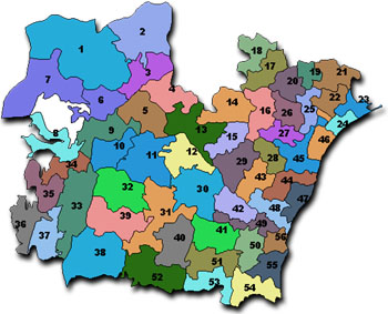
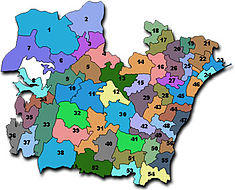 Mandalas in Prakasam Dist
- Prakasam Engineering College
- RISE Groups of Institutions, Ongole
- RISE Prakasam Group of Institutions, Ongole
- RISE Prakasam Engineering College, Ongole
- RISE Prakasam MBA College, Ongole
- RISE Prakasam MCA College, Ongole
- RISE Gandhi Group of Institutions, Ongole
- RISE Gandhi Engineering College, Ongole
- RISE Gandhi MBA College, Ongole
- RISE Gandhi MCA College, Ongole
- SSN Engineering College
- Rao & Naidu Engineering College
- QIS Engineering College
- Chirala Engineering College
- Dr Samuel George Institute of Engineering & Technology
- St Anns College of Engineering & Technology
- VRS & YRN College of Engineering & Technology
- Malineni Lakshmaiah Engineering College
- ABR college of engg&technology,KANIGIRI
- Pace Institute Of Technology & Sciences
References
- ^ Law, Gwillim (2011-09-25). "Districts of India". Statoids. http://www.statoids.com/yin.html. Retrieved 2011-10-11.
- ^ "83 districts under the Security Related Expenditure Scheme". IntelliBriefs. 2009-12-11. http://intellibriefs.blogspot.com/2009/12/naxal-menace-83-districts-under.html. Retrieved 2011-09-17.
- ^ Srivastava, Dayawanti et al. (ed.) (2010). "States and Union Territories: Andhra Pradesh: Government". India 2010: A Reference Annual (54th ed.). New Delhi, India: Additional Director General, Publications Division, Ministry of Information and Broadcasting (India), Government of India. pp. 1111-1112. ISBN 978-81-230-1617-7.
- ^ "Island Directory Tables: Islands by Land Area". United Nations Environment Program. 1998-02-18. http://islands.unep.ch/Tiarea.htm. Retrieved 2011-10-11. "Seram 17,454"
- ^ a b c "District Level Household and Facility Survey (DLHS-3), 2007-08: India. Andhra Prades" (PDF). International Institute for Population Sciences and Ministry of Health and Family Welfare. 2010. http://www.rchiips.org/pdf/rch3/report/AP.pdf. Retrieved 2011-10-03.
- ^ "How Do I? : Obtain Marriage Certificate". National Portal Content Management Team, National Informatics Centre. 2005. http://india.gov.in/howdo/howdoi.php?service=3. Retrieved 2011-10-03. "To be eligible for marriage, the minimum age limit is 21 for males and 18 for females."
- ^ a b c d e f "District Census 2011". Census2011.co.in. 2011. http://www.census2011.co.in/district.php. Retrieved 2011-09-30.
- ^ US Directorate of Intelligence. "Country Comparison:Population". https://www.cia.gov/library/publications/the-world-factbook/rankorder/2119rank.html. Retrieved 2011-10-01. "Panama 3,460,462 July 2011 est."
- ^ "2010 Resident Population Data". U. S. Census Bureau. http://2010.census.gov/2010census/data/apportionment-pop-text.php. Retrieved 2011-09-30. "Connecticut 3,574,097"
External links
- Official site
- Prakasam (district) travel guide from Wikitravel
- www.Ongolelive.com
- http://www.aptourism.com
- http://www.shadows-ngo.org

Mahbubnagar district Guntur district Kurnool district 
Bay of Bengal  Prakasam district

YSR district Nellore district Municipalities of Andhra Pradesh Municipal
CorporationsHyderabad · Visakhapatnam · Vijayawada · Warangal · Rajahmundry · Kakinada · Guntur · Nellore · Kadapa · Kurnool · Tirupathi · Eluru · Anantapur · Karimnagar · Ramagundam · Nizamabad
Municipalities Srikakulam · Amudalavalasa · Ichchapuram · Palasa Kasibugga · Rajam · Vizianagaram · Bobbili · Parvathipuram · Salur · Anakapalle · Bheemunipatnam · Amalapuram · Tuni · Samalkota · Ramachandrapuram · Pithapuram · Mandapeta · Peddapuram · Bhimavaram · Palakol · Tadepalligudem · Narsapur · Nidadavole · Tanuku · Kovvur · Machilipatnam · Gudivada · Jaggaiahpet · Nuzvid · Pedana · Tenali · Narasaraopet · Bapatla · Repalle · Chilakaluripet · Ponnur · Mangalagiri · Macherla · Sattenapalle · Vinukonda · Piduguralla · Ongole · kanigiri · Addanki · Chirala · Markapur · Kandukur · Gudur · Kavali · Venkatagiri · Chittoor · Madanapalle · Srikalahasti · Punganur · Puttur · Palamaneru · Nagari · Hindupur · Guntakal · Tadpatri · Dharmavaram · Kadiri · Rayadurg · Nandyal · Adoni · Yemmiganur · Dhone · Proddatur · Pulivendula · Jammalamadugu · Rajampet · Rayachoti · Badvel · Jangaon · Jagtial · Sircilla · Koratla · Metpally · Khammam · Kothagudem · Palwancha · Yellandu · Bhadrachalam · Manuguru · Sathupalli · Adilabad · Bellampalli · Mancherial · Nirmal · Kaghaznagar · Mandamarri · Bhainsa · Tandur · Vicarabad · Nalgonda · Suryapet · Miryalguda · Bhongir · Sangareddi · Siddipet · Sadasivpet · Zahirabad · Medak · Mahbubnagar · Gadwal · Narayanpet · Wanaparthi · Kollapur · Kamareddy · Bodhan · Armoor
Nagar
Panchayats State of Andhra PradeshCapital: Hyderabad
Topics Districts - Adilabad
- Anantapur
- Chittoor
- East Godavari
- Guntur
- Hyderabad
- Karimnagar
- Khammam
- Krishna
- Kurnool
- Mahabubnagar
- Medak
- Nalgonda
- Nellore
- Nizamabad
- Prakasam
- Ranga Reddy
- Srikakulam
- Visakhapatnam
- Vizianagaram
- Warangal
- West Godavari
- YSR
Major cities Categories:- Districts of Andhra Pradesh
- 1970 establishments
- Prakasam district


Wikimedia Foundation. 2010.