- Seram Island
-
For the village in Nepal, see Seram, Nepal.
Seram Island 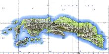
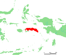
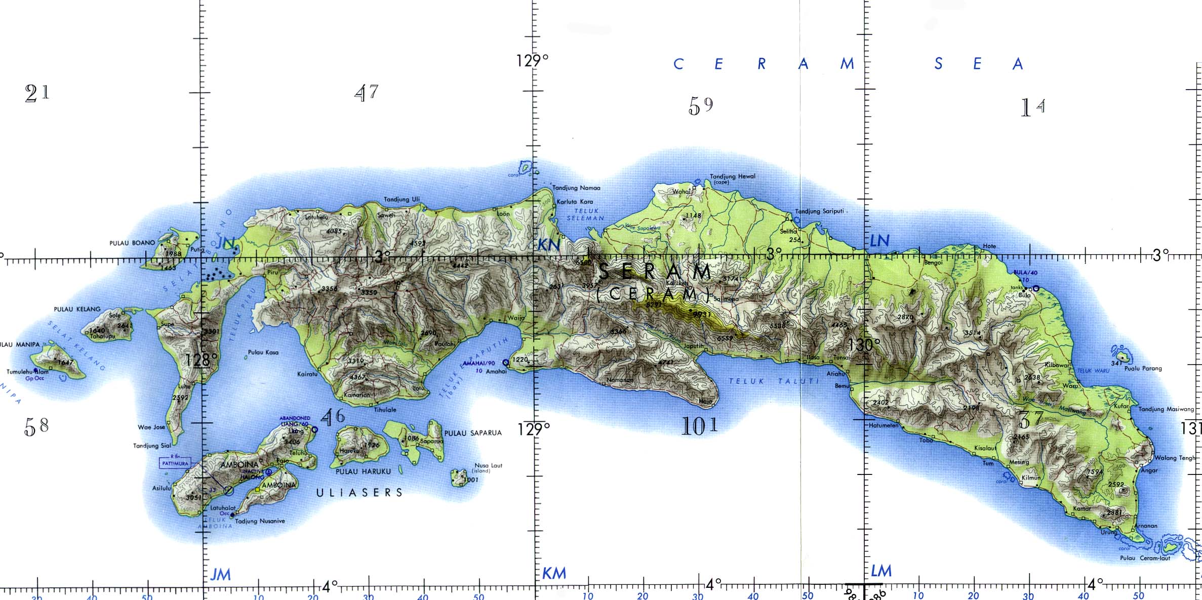
Geography Location South East Asia Archipelago Molucca Islands Area 17,100 km2 (6,600 sq mi) Area rank 52nd Highest elevation 3,019 m (9,905 ft) Highest point Binaiya Country IndonesiaDemographics Population 218,993 (as of 2003) Seram (formerly Ceram, also called Seran or Serang) is an island in the Maluku province of Indonesia. It is located north of Ambon Island. The chief port/town is Masohi.
Contents
Geography and geology
Seram is traversed by a central mountain range, the highest point of which, Mount Binaiya, is covered with dense rain forests. Its remarkably complex geology is due to its location at the meeting of several tectonic microplates, that has been described as "one of the most tectonically complex areas on Earth".[1] Seram actually falls on its own microplate that has been twisted around by 80° in the last 8 million years [2] by the relatively faster movement of the Papua microplate. Meanwhile, along with the northward push of the Australian Plate, this has resulted in the uplift that gives north-central Seram peaks of over 3000m.
Ecology
Seram island is remarkable for its high degree of localised bird endemism.[3] From the 117 species of bird on the island, 14 are endemic, including the Eclectus Parrot, Purple-naped Lory, Salmon-crested Cockatoo, Lazuli Kingfisher, Sacred Kingfisher, Grey-necked Friarbird and Moluccan King Parrot.[4]
The mammals found on Seram include Asian species (Murid rodents) as well as Australasian marsupials. The montane area of Seram supports the greatest number of endemic mammals of any island in the region. It harbors 38 mammal species and includes nine species that are endemic or near endemic, several of which are limited to montane habitats. These include the Seram Bandicoot, Moluccan Flying Fox, Seram Flying-fox, Manusela Mosaic-tailed Rat, Spiny Ceram Rat and the Ceram Rat, all considered threatened.[5]
Saltwater crocodiles exist within some of the island's rivers, including the Salawai River.
In the eastern part of the island, Manusela National Park has been established in 1997, covering an area of 1,890 km² (11% of the island).[4]
History
Most central Moluccans consider Seram to be their original ancestral home and it is still known colloquially as Nusa Ina (Mother Island).[6][7] In the fifteenth and sixteenth centuries, Seram was generally within the sphere of influence of Ternate, although it was often ruled more directly by the Ternaten vassal state of Buru. Portuguese missionaries were active there in the 16th century. Dutch trading posts were opened in the early 17th century, and the island came under nominal Dutch control c. 1650. In the 1780s, Seram provided a key base of support for Prince Nuku of Tidore's long-running rebellion against Dutch rule. From 1954 until 1962 the island's mountain terrain was the scene of an armed guerilla struggle against Indonesian rule by the counter revolutionary Republic of South Moluccas movement led by Soumokil.
Administration
Seram includes three of the regencies within the province of Maluku. West Seram (Kabupaten Seram Bagian Barat), capital at Dataran Hunipopu, had a population (2003) of 140,657; and Eastern Seram (Kabupaten Seram Bagian Timur), capital at Dataran Hunimoa, had a population (2003) of 78,336. The Central Maluku Regency (Kabupaten Maluku Tengah), with its capital at Masohi, includes the middle part of Ceram, as well as some other smaller islands.
Religion
 View from a boat towards Tulehu, on the North Seram coast
Seram has been traditionally associated with the animism of the indigenous Alfur (or Nuaulu), a West Melanesian people who reputedly retained a custom of headhunting until the 1940s.[8] Today, however, most of the population of Seram today is either Muslim or Christian due to both conversion and immigration. Seram was affected by the violent inter-religious conflict that swept Maluku province starting in late 1998, resulting in tens of thousands of displaced persons across the province[9] but after the Malino II Accord agreement tempers cooled. Seram has been peaceful for many years but towns like Masohi remain informally divided into de facto Christian and Muslim sections. Around 7,000 people belonging to the Manusela tribe follow Hinduism.[10]
Economy
Copra, resin, sago, and fish are important products. Oil is exploited in the northeast near Bula by CITIC Seram Energy[11] who took over from KUFPEC (Indonesia) Limited in 2006.[12]
See also
References
- ^ http://www.ee.usyd.edu.au/suss/Bulls/37(2)/seramgeology.html
- ^ Linthout, K. and Helmers, H. 1994 Pliocene obducted, rotated and migrated ultramafic rocks and obduction-induced anatectic granite, SW Seram and Ambon, Eastern Indonesia. J. Southeast Asian Earth Sci. 9(1-2), pp95-109 1994 Academic Paper
- ^ BirdLife International: Saving Asia's threatened birds, 2003, retrieved 19 May 2010
- ^ a b Inonesian Ministry of Forestry, retrieved 19 May 2010
- ^ WWF: Seram rain forests, retrieved 19 May 2010
- ^ http://www.ema-huaresi.com/homepage.htm
- ^ Lonely Planet Indonesia 7th Edition, page 840
- ^ Lonely Planet Indonesia, 8th edition p762
- ^ http://www.hrw.org/reports/1999/ambon/amron-01.htm
- ^ Note: the Indonesia definition of Hinduism is a complex legal matter; in effect Hinduism was a supercategory used to define non Islamic and Christian religions hence any pagan style religion. This is not to say that it is not related to Hinduism at its root, however.
- ^ http://www.citicresources.com/eng/business/oil.htm
- ^ http://www.kufpec.com/KUFPEC/en-US/Operations/SouthEastAsia/Indonesia/
External links
Coordinates: 3°08′S 129°30′E / 3.133°S 129.5°E
Islands of Maluku North Maluku province Maluku province Categories:- Ecoregions
- Seram Island


Wikimedia Foundation. 2010.