- Dorrance, Kansas
-
Dorrance, Kansas — City — Location of Dorrance, Kansas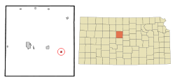 Detailed map of Dorrance
Coordinates: 38°50′49″N 98°35′18″W / 38.84694°N 98.58833°WCoordinates: 38°50′49″N 98°35′18″W / 38.84694°N 98.58833°W Country United States State Kansas County Russell Incorporated 1910 Area – Total 0.3 sq mi (0.9 km2) – Land 0.3 sq mi (0.9 km2) – Water 0.0 sq mi (0.0 km2) Elevation 1,729 ft (527 m) Population (2010)[1] – Total 185 – Density 616.7/sq mi (238.1/km2) Time zone Central (CST) (UTC-6) – Summer (DST) CDT (UTC-5) ZIP code 67634 Area code(s) 785 FIPS code 20-18325[2] GNIS feature ID 0475332[3] Dorrance is a city in Russell County, Kansas, United States.[4] As of the 2010 census, the city population was 185.[1]
Contents
History
The Kansas Pacific Railway reached the site of Dorrance in June 1867. German, English, and Irish settlers followed shortly thereafter, forming a small community by 1870.[5] In early 1872, they were joined by a colony of settlers from Pennsylvania.[6] A prairie fire destroyed much of the community's business district in March 1879.[5] The town of Dorrance was formally laid out in 1880, named for Oliver Dorrance, the railroad superintendent.[7][8] The first post office opened in July 1883. Dorrance was incorporated in April 1910 and became a center of goods and services for eastern Russell County.[9]
Geography
Dorrance is located at 38°50′49″N 98°35′18″W / 38.84694°N 98.58833°W (38.846977, -98.588338)[10] at an elevation of 1,729 feet (527 m).[3] It lies in the Smoky Hills region of the Great Plains approximately 3 miles (4.8 km) north of the Smoky Hill River and 6 miles (9.7 km) south of Wilson Lake.[4][11] Dorrance is located in north-central Kansas 102 miles (164 km) northwest of Wichita and 214 miles (344 km) west of Kansas City.[12] Located 1/2 mile (0.8 km) south of Interstate 70, it is roughly 15 miles (24 km) east-southeast of Russell, the county seat.[11]
According to the United States Census Bureau, the city has a total area of 0.3 square miles (0.78 km2), all of it land.[13]
Demographics
Historical populations Census Pop. %± 1910 281 — 1920 299 6.4% 1930 325 8.7% 1940 414 27.4% 1950 385 −7.0% 1960 331 −14.0% 1970 234 −29.3% 1980 220 −6.0% 1990 195 −11.4% 2000 205 5.1% 2010 185 −9.8% U.S. Decennial Census As of the 2010 census, there were 185 people, 85 households, and 51 families residing in the city. The population density was 616.7 people per square mile (238.1/km²). There were 113 housing units at an average density of 376.7 per square mile (125.6/km²). The racial makeup of the city was 96.8% White, 2.7% American Indian, and 0.5% Asian. Hispanics or Latinos of any race were 0.5% of the population.[1]
There were 85 households out of which 25.9% had children under the age of 18 living with them, 51.8% were married couples living together, 2.4% had a male householder with no wife present, 5.9% had a female householder with no husband present, and 40.0% were non-families. 36.5% of all households were made up of individuals, and 14.1% had someone living alone who was 65 years of age or older. The average household size was 2.18, and the average family size was 2.84.[1]
In the city, the population was spread out with 21.6% under the age of 18, 4.5% from 18 to 24, 22.6% from 25 to 44, 28.6% from 45 to 64, and 22.7% who were 65 years of age or older. The median age was 46.5 years. For every 100 females, there were 98.9 males. For every 100 females age 18 and over, there were 90.8 males age 18 and over.[1]
As of 2009, the median income for a household in the city was $27,000, and the median income for a family was $33,333. Males had a median income of $43,750 versus $35,417 for females. The per capita income for the city was $11,490. About 33.3% of families and 49.3% of the population were below the poverty line, including 66.7% of those under the age 18 and 0.0% of those age 65 or over.[14]
Government
Dorrance is a city of the third class with a mayor-council form of government. The city council consists of five members, and it meets on the second Saturday of each month.[15]
Education
Dorrance lies within Unified School District (USD) 328, based in Lorraine, Kansas.[16] Local public school students attend school in nearby Wilson.[17]
Transportation
Interstate 70 and U.S. Route 40 run concurrently east-west less than a mile north of the city. The old alignment of U.S. 40 runs southeast-northwest through Dorrance, intersecting 200th Boulevard, a paved county road formerly designated K-231, which runs north-south along the city's eastern edge.[4][11][18]
The Kansas Pacific (KP) line of the Union Pacific Railroad runs southeast-northwest through Dorrance parallel to the old alignment of U.S. 40.[19]
Culture
Points of interest
The Dorrance Historical Society Museum, located downtown, exhibits artifacts from the community's history.[5][20]
In popular culture and the arts
Dorrance was among the filming locations for the 1973 film Paper Moon.[21]
Toss Back, the company which invented and first produced the "Snap Back" rim used in NBA basketball, was located in Dorrance.[22]
References
- ^ a b c d e "American FactFinder 2". United States Census Bureau. http://factfinder2.census.gov/faces/nav/jsf/pages/index.xhtml. Retrieved 2011-08-26.
- ^ "American FactFinder". United States Census Bureau. http://factfinder.census.gov. Retrieved 2008-01-31.
- ^ a b "US Board on Geographic Names". United States Geological Survey. 2007-10-25. http://geonames.usgs.gov. Retrieved 2008-01-31.
- ^ a b c "2003-2004 Official Transportation Map". Kansas Department of Transportation. 2003. http://www.ksdot.org/burtransplan/maps/HistoricStateMaps/2003-04Mapside.pdf. Retrieved 2010-12-12.
- ^ a b c "Area Attractions". Russell Area Chamber of Commerce. http://www.russellks.org/attractions.html. Retrieved 2011-08-28.
- ^ Cutler, William G. (1883). "Russell County, Part 2". History of the State of Kansas. Chicago: A. T. Andreas. http://www.kancoll.org/books/cutler/russell/russell-co-p2.html. Retrieved 2011-08-28.
- ^ "Homesteading in Russell County - Dorrance". Kansas Heritage Project. Fort Hays State University. http://www.fhsu.edu/library/ksheritage/Dorrance/. Retrieved 2011-08-28.
- ^ The Biographical Directory of the Railway Officials of America for 1887. Chicago: The Railway Age Publishing Co.. 1887. p. 89. http://books.google.com/books?id=m4BKWu0Jf0EC&lpg=PA89&dq=Dorrance%20%22Kansas%20Pacific%22%20superintendent&pg=PA89#v=onepage&q=Dorrance%20%22Kansas%20Pacific%22%20superintendent&f=false. Retrieved 2011-08-28.
- ^ "Dorrance State Bank - Dorrance, Kansas". Register of Historic Kansas Places Registration Form. Kansas Historical Society. http://www.kshs.org/resource/national_register/nominationsNRDB/Russell_DorranceStateBankSR.pdf. Retrieved 2011-08-28.
- ^ "US Gazetteer files: 2010, 2000, and 1990". United States Census Bureau. 2011-02-12. http://www.census.gov/geo/www/gazetteer/gazette.html. Retrieved 2011-04-23.
- ^ a b c "General Highway Map - Russell County, Kansas". Kansas Department of Transportation. 2010-10-01. http://www.ksdot.org/burtransplan/maps/county-pdf/russell.PDF. Retrieved 2010-12-12.
- ^ "City Distance Tool". Geobytes. http://www.geobytes.com/citydistancetool.htm. Retrieved 2010-10-23.
- ^ "Kansas: 2000 - Population and Housing Counts". United States Census Bureau. July 2003. p. 26. http://www.census.gov/prod/cen2000/phc-3-18.pdf. Retrieved 2010-12-12.
- ^ "Dorrance city, Kansas - Selected Economic Characteristics: 2005-2009". 2005-2009 American Community Survey 5-Year Estimates. United States Census Bureau. http://factfinder.census.gov/servlet/ADPTable?_bm=y&-geo_id=16000US2018325&-qr_name=ACS_2009_5YR_G00_DP5YR3&-ds_name=ACS_2009_5YR_G00_&-_lang=en&-_sse=on. Retrieved 2011-08-28.
- ^ "Dorrance". Directory of Kansas Public Officials. The League of Kansas Municipalities. http://www.lkm.org/directory/cities.php?ID=464. Retrieved 2011-08-28.
- ^ "Kansas Unified School Districts (map)". Kansas State Department of Education. http://www3.ksde.org/eddir/usd_map.pdf. Retrieved 2011-08-28.
- ^ "New District Map". USD 328. http://www.usd328.org/?q=district/district-home/consolidation-information/new-district-map. Retrieved 2011-08-28.
- ^ "Official 1960-61 Kansas Highway Map". Kansas Department of Transportation. http://www.ksdot.org/burtransplan/maps/HistoricStateMaps/1960Mapside.pdf. Retrieved 2010-12-12.
- ^ "UPRR Common Line Names". Union Pacific Railroad. http://www.uprr.com/aboutup/maps/attachments/upcomnam.pdf. Retrieved 2010-10-23.
- ^ "Russell County". Blue Skyways. State Library of Kansas. http://skyways.lib.ks.us/counties/RS/. Retrieved 2011-08-28.
- ^ "Paper Moon". Moviediva. Nov. 2010. http://www.moviediva.com/MD_root/reviewpages/MDPaperMoon.htm. Retrieved 2011-03-06.
- ^ Bickel, Amy (2008-04-05). "Still in the game". The Hutchinson News. http://www.hutchnews.com/Todaystop/goal. Retrieved 2011-03-06.
External links
- City
- Schools
- USD 112, local school district
- Maps
- Dorrance City Map, KDOT
- Russell County Map, KDOT
Municipalities and communities of Russell County, Kansas Cities 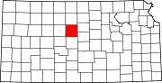
Townships Big Creek | Center | Fairfield | Fairview | Grant | Lincoln | Luray | Paradise | Plymouth | Russell | Waldo | Winterset
Unincorporated
communitiesCategories:- Cities in Kansas
- Populated places in Russell County, Kansas


Wikimedia Foundation. 2010.