- Milberger, Kansas
-
Milberger, Kansas — Unincorporated community — 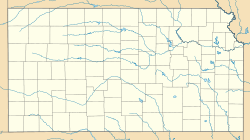
 Milberger, Kansas
Coordinates: 38°42′43″N 98°54′44″W / 38.71194°N 98.91222°WCoordinates: 38°42′43″N 98°54′44″W / 38.71194°N 98.91222°W Country United States State Kansas County Russell Founded 1884 Elevation 1,854 ft (565 m) Time zone Central (CST) (UTC-6) – Summer (DST) CDT (UTC-5) ZIP code 67665 Area code(s) 785 GNIS feature ID 475411[1] Milberger is an unincorporated community in Lincoln Township, Russell County, Kansas, United States.[2]
Contents
History
Volga German colonists founded Milberger in 1884. Predominantly Lutheran, they established several churches in and around the community, most of which closed by 1980.[3][4] A rural post office operated in Milberger from 1903 to 1911.[5]
Geography
Milberger is located at 38°42′43″N 98°54′44″W / 38.71194°N 98.91222°W (38.7119562, -98.9123098) at an elevation of 1,854 feet (565 m).[1] It lies on the west side of Landon Creek roughly 4.5 miles (7 km) south of the Smoky Hill River in the Smoky Hills region of the Great Plains.[6][7] Milberger is approximately 3.5 miles (6 km) west of U.S. Route 281, 10.5 miles (17 km) south of Interstate 70, and 12 miles (20 km) south-southwest of Russell, the county seat.[7]
Transportation
Milberger lies at the intersection of Milberger Road, a paved county road which runs north-south, and Michaelis Road, an unpaved county road which runs east-west.[7][8]
References
- ^ a b "US Board on Geographic Names". United States Geological Survey. 2007-10-25. http://geonames.usgs.gov. Retrieved 2008-01-31.
- ^ "General Highway Map - Russell County, Kansas". Kansas Department of Transportation. 1975. http://www.ksdot.org/burtransplan/maps/HistoricCountyTWP/russellCoTWP.PDF. Retrieved 2010-12-12.
- ^ Keel, William D. (2006). "Deitsch, Däätsch, Düütsch, and Dietsch: The Varieties of Kansas German Dialects after 150 Years of German Group Settlement in Kansas". University of Kansas. http://www2.ku.edu/~germanic/LAKGD/William_Keel_Essay.shtml. Retrieved 2010-08-15.
- ^ Bauer, Reuben A. (2004). "German Hymns Heard Again". http://www.webspawner.com/users/refroom3/. Retrieved 2010-08-15.
- ^ "Post Offices in Kansas". Kansas State Historical Society. http://www.kshs.org/genealogists/places/postoffices.htm. Retrieved 2010-08-15.
- ^ "2003-2004 Official Transportation Map". Kansas Department of Transportation. 2003. http://www.ksdot.org/burtransplan/maps/HistoricStateMaps/2003-04Mapside.pdf. Retrieved 2010-12-12.
- ^ a b c "General Highway Map - Russell County, Kansas". Kansas Department of Transportation. 2010-10-01. http://www.ksdot.org/burtransplan/maps/county-pdf/russell.PDF. Retrieved 2010-12-12.
- ^ "Milberger, KS 67665". Google Maps. http://maps.google.com/maps/place?ftid=0x87a3c142e907e109:0xf02280f011e3cfd7&q=Milberger,+KS&hl=en&ved=0CA0Q-QswAA&ei=flsFTaydCKS6ywSL76isDQ&sll=38.711956,-98.91231&sspn=0.017414,0.032015&ie=UTF8&ll=38.72851,-98.934546&spn=0,0&z=14. Retrieved 2010-12-12.
Municipalities and communities of Russell County, Kansas Cities 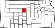
Townships Big Creek | Center | Fairfield | Fairview | Grant | Lincoln | Luray | Paradise | Plymouth | Russell | Waldo | Winterset
Unincorporated
communitiesBalta | Dubuque | Fairport | Homer | Milberger
Categories:- Populated places in Russell County, Kansas
- Unincorporated communities in Kansas


Wikimedia Foundation. 2010.