- Olmitz, Kansas
-
Olmitz, Kansas — City — Location of Olmitz, Kansas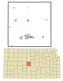
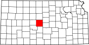
Coordinates: 38°30′59″N 98°56′15″W / 38.51639°N 98.9375°WCoordinates: 38°30′59″N 98°56′15″W / 38.51639°N 98.9375°W Country United States State Kansas County Barton Area – Total 0.2 sq mi (0.4 km2) – Land 0.2 sq mi (0.4 km2) – Water 0.0 sq mi (0.0 km2) Elevation 2,014 ft (614 m) Population (2010)[1] – Total 114 – Density 570/sq mi (220.1/km2) Time zone Central (CST) (UTC-6) – Summer (DST) CDT (UTC-5) ZIP code 67564 Area code(s) 620 FIPS code 20-52750[2] GNIS feature ID 0475502[3] Olmitz is a city in Barton County, Kansas, United States. As of the 2010 census, the city population was 114.[1]
Contents
Geography
Olmitz is located at 38°30′59″N 98°56′15″W / 38.51639°N 98.9375°W (38.516460, -98.937386)[4]. According to the United States Census Bureau, the city has a total area of 0.2 square miles (0.52 km2), all of it land.
Demographics
Historical populations Census Pop. %± 1990 130 — 2000 138 6.2% 2010 114 −17.4% U.S. Decennial Census As of the census[2] of 2000, there were 138 people, 62 households, and 37 families residing in the city. The population density was 828.6 people per square mile (313.4/km²). There were 71 housing units at an average density of 426.3 per square mile (161.3/km²). The racial makeup of the city was 96.38% White, and 3.62% from two or more races. Hispanic or Latino of any race were 1.45% of the population.
There were 62 households out of which 32.3% had children under the age of 18 living with them, 46.8% were married couples living together, 8.1% had a female householder with no husband present, and 40.3% were non-families. 37.1% of all households were made up of individuals and 17.7% had someone living alone who was 65 years of age or older. The average household size was 2.23 and the average family size was 3.00.
In the city the population was spread out with 27.5% under the age of 18, 8.0% from 18 to 24, 27.5% from 25 to 44, 21.0% from 45 to 64, and 15.9% who were 65 years of age or older. The median age was 37 years. For every 100 females there were 97.1 males. For every 100 females age 18 and over, there were 104.1 males.
The median income for a household in the city was $31,429, and the median income for a family was $34,500. Males had a median income of $25,500 versus $13,333 for females. The per capita income for the city was $12,998. There were 11.9% of families and 12.9% of the population living below the poverty line, including 14.6% of under eighteens and 7.4% of those over 64.
References
- ^ a b "2010 City Population and Housing Occupancy Status". U.S. Census Bureau. http://factfinder2.census.gov/faces/tableservices/jsf/pages/productview.xhtml?pid=DEC_10_PL_GCTPL2.ST13&prodType=table. Retrieved September 21, 2011.
- ^ a b "American FactFinder". United States Census Bureau. http://factfinder.census.gov. Retrieved 2008-01-31.
- ^ "US Board on Geographic Names". United States Geological Survey. 2007-10-25. http://geonames.usgs.gov. Retrieved 2008-01-31.
- ^ "US Gazetteer files: 2010, 2000, and 1990". United States Census Bureau. 2011-02-12. http://www.census.gov/geo/www/gazetteer/gazette.html. Retrieved 2011-04-23.
External links
- City
- Schools
- USD 431, local school district
- Maps
- Olmitz City Map, KDOT
- Barton County Map, KDOT
Municipalities and communities of Barton County, Kansas Cities Albert | Claflin | Ellinwood | Galatia | Great Bend | Hoisington | Olmitz | Pawnee Rock | Susank
Townships Albion | Beaver | Buffalo | Cheyenne | Clarence | Cleveland | Comanche | Eureka | Fairview | Grant | Great Bend | Independent | Lakin | Liberty | Logan | North Homestead | Pawnee Rock | South Bend | South Homestead | Union | Walnut | Wheatland
Unincorporated
communitiesCategories:- Cities in Kansas
- Populated places in Barton County, Kansas


Wikimedia Foundation. 2010.