- Comanche Township, Barton County, Kansas
-
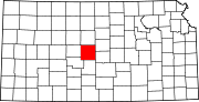
Comanche Township — Township — Location in Barton County
Coordinates: 38°18′16″N 098°35′25″W / 38.30444°N 98.59028°WCoordinates: 38°18′16″N 098°35′25″W / 38.30444°N 98.59028°W Country United States State Kansas County Barton Area – Total 64.49 sq mi (167.02 km2) – Land 64.42 sq mi (166.85 km2) – Water 0.07 sq mi (0.18 km2) 0.11% Elevation 1,791 ft (546 m) Population (2000) – Total 452 – Density 7/sq mi (2.7/km2) GNIS feature ID 0475765 Comanche Township is a township in Barton County, Kansas, USA. As of the 2000 census, its population was 452.
Contents
Geography
Comanche Township covers an area of 64.49 square miles (167.0 km2) and contains no incorporated settlements.
The stream of Walnut Creek runs through this township.
Transportation
Comanche Township contains one airport or landing strip, Peters Landing Field.
References
External links
Municipalities and communities of Barton County, Kansas Cities Albert | Claflin | Ellinwood | Galatia | Great Bend | Hoisington | Olmitz | Pawnee Rock | Susank
Townships Albion | Beaver | Buffalo | Cheyenne | Clarence | Cleveland | Comanche | Eureka | Fairview | Grant | Great Bend | Independent | Lakin | Liberty | Logan | North Homestead | Pawnee Rock | South Bend | South Homestead | Union | Walnut | Wheatland
Unincorporated
communitiesCategories:- Townships in Barton County, Kansas
- Kansas geography stubs


Wikimedia Foundation. 2010.