- Zvezdara
-
Zvezdara
Звездара— Municipality — 
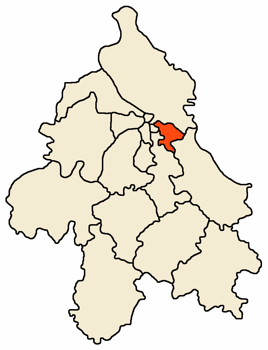
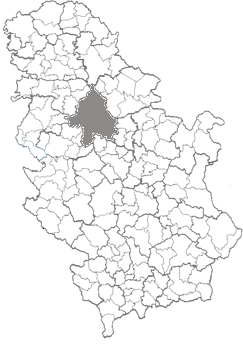
FlagLocation within the City of Belgrade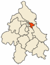 Location within Serbia
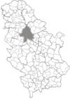
Coordinates: 44°47′N 20°32′E / 44.783°N 20.533°ECoordinates: 44°47′N 20°32′E / 44.783°N 20.533°E Country Serbia City Belgrade Status Urban Settlements 1 Government – Type Municipality of Belgrade – Mun. president Milan Popović (DS) Area – Total 31 km2 (12 sq mi) Elevation 270 m (886 ft) Population (2005) – Total 137,523 – Density 4.436/km2 (11.5/sq mi) Time zone CET (UTC+1) – Summer (DST) CEST (UTC+2) Postal code 11000 Area code(s) +381 11 Car plates BG Website www.zvezdara.rs Zvezdara (Serbian Cyrillic: Звездара, pronounced [zv̞ě̞zdara]) is a hill, forest, urban neighborhood and one of 17 municipalities which constitute City of Belgrade, the capital of Serbia.
Contents
Neighborhood
Location
The Zvezdara neighborhood (44°48′00″N 20°30′29″E / 44.8°N 20.508°E) is located south-east of downtown Belgrade. In its original sense, the neighborhood of Zvezdara comprises areas around the Zvezdara Forest, including the neighborhood of Zvezdara II. It borders the neighborhoods of Bogoslovija and Karaburma on the north, Ćalije on the north-east (all in the municipality of Palilula), Mirijevo on the east, Mali Mokri Lug on the south-east, Cvetkova Pijaca and Konjarnik on the south, Lion on the south-west and Bulbuder on the west. The area had a population of 10,095 by the 2002 census of population. However, after the creation of the municipality in 1955, the entire section west and south-west of Zvezdara is today considered as part of it in a narrow sense (Lion, Bulbuder, Lipov Lad, Cvetkova Pijaca, etc.).
Name and history
Until the 1930s, the Zvezdara hill was known as Veliki Vračar (Great Vračar). In the 19th century the foothills were not urbanized and, being far from the city center, were used by the Belgraders as a resort and picnic area, named Baba Ružin kraj ("Grandma Ruža's neighborhood"). In 1929-32 an observatory designed by Czech-born architect Jan Dubový (1892–1969) was built on top of the hill. The observatory was originally called zvezdara ("star-house") in Serbian, so the hill and the developing suburban area of Belgrade around it was named that way soon. In time, Latinism opservatorija replaced zvezdara, which in turn completely disappeared from spoken language as such, but remained as a name of Belgrade's neighborhood. As a result, many today believe Zvezdara was named that way simply after stars (Serbian zvezda, star). In 1935 the Clinical Center (KBC) Zvezdara was built as a bequest by wealthy Serbian merchant Nikola Spasić. The area was rich in water, originally used for city waterworks. Several public drinking fountains were built (like Pasha's fountain, dating from the First Serbian Uprising, in modern Živka Davidovića street or the Fountain of the third-class reservists, for the killed soldiers of the World War I. near KBC Zvezdara).[1]
Municipality
Location
The municipality of Zvezdara is located east of Belgrade and occupied almost the entire eastern urban section of the city. It borders the municipalities of Paliula on the north-west, north and north-east, Grocka on the east and south-east, Voždovac on the south and south-west and Vračar on the west.
Geography
Despite being one of Belgrade's minor municipalities in terms of area (31 square kilometer), Zvezdara covers some of the highest sections of urban Belgrade, including the hills:
- Stojčino Brdo (270 meters)
- Orlovica (265 meters, also, but incorrectly, named Orlovača on some city maps)
- Zvezdara (253 meters)
- Mokroluško Brdo (234 meters)

Zvezdara basically has no real city parks, but has two large wooded areas, Zvezdara Forest (with an arranged park within, in the north-central part) and the northern section of Stepin Lug in the southern part of the municipality. Peti Park (Fifth park) is a minute green area in the neighborhood of Lipov Lad which gained a lot of publicity in the mid 2000s with a public movement to keep the area green.
Zvezdara does not come out on the river banks of two major Belgrade's rivers (the Danube and Sava). The major water flows in the municipality are two creeks, both of which are partially conducted underground in the city sewer: Mokroluški potok and Mirijevski potok. For several hundred meters, the Bolečica river flows through the southernmost part of the municipality, near Bubanj Potok.
Population
The population of modern municipality of Zvezdara had a steady, large growth until 1980s and 1990s when birthrates plunged in all of Serbia. But Zvezdara remains one of the most densely populated areas in entire Serbia, with 4,436 inhabitants per square kilometer in 2005. Population of Zvezdara according to the official censuses of population [2]:
- 1948 - 56,177
- 1953 - 66,580
- 1961 - 88,919
- 1971 - 112,938
- 1981 - 128,753
- 1991 - 135,694
- 2002 - 132,621
- 2005 - 137,523 [3]
Ethnic groups
Ethnic composition by the 2002 census of population:
- Serbs - 119,570 (or 90.16%)
- Montenegrins - 1,715 (or 1,29%)
- Yugoslavs - 1,609 (or 1,21%)
- Roma - 1,251 (or 0,94%)
- Macedonians - 790 (or 0,60%)
Neighborhoods
- Bulbuder
- Crveni Krst
- Cvetanova Ćuprija
- Denkova Bašta
- Đeram
- Konjarnik
- Konjarnik I
- Konjarnik II
- Konjarnik III
- Lion
- Lipov Lad
- Mali Mokri Lug
- Mirijevo
- Mirijevo II
- Mirijevo III
- Mirijevo IV
- Novo Mirijevo
- Orlovsko Naselje
- Padina
- Rudo
- Slavujev Venac
- Stari Đeram
- Staro Mirijevo
- Učiteljsko Naselje
- Veliki Mokri Lug
- Vukov Spomenik
- Zeleno Brdo
- Olimp
- Zvezdara II
History and administration
The municipality of Zvezdara was created on September 1, 1955, from (at that time) new neighborhoods around the observatory. On January 1, 1957 Zvezdara was greatly enlarged as the municipalities of Stari Đeram and Mali Mokri Lug were annexed to it. Villages of Kaluđerica, Vinča and Leštane (previously parts of Mali Mokri Lug) were later detached and annexed to the municipality of Grocka. In the first half of the 1970s, all settlements in the municipality became part of the Belgrade city proper (uža teritorija grada) so the entire municipality of Zvezdara is today one of six municipalities which are completely part of urban Belgrade. Recent presidents of the Municipal assembly were:
- Vučeta Mandić (from 1996 to 2000)
- Petar Moravac (born 1964; from 2000 to November 19, 2004)
- Milan Popović (born 1948; from November 19, 2004 to February 18, 2005)
- Ljubiša Stojmirović (born 1950; from February 18, 2005 to June 28, 2005)
- Milan Popović (2nd time; from June 28, 2005)
Economy
Industry
As many areas of modern Zvezdara municipalities were villages and rural areas annexed to it in the 1950s, entire southern and eastern sections (Padina, Veliki Mokri Lug, Mali Mokri Lug, Mirijevo) are without industry. Industrial facilities are mostly grouped in two sections: Konjarnik (plastics Bukulja, precise and optical instruments Precizna mehanika, white metals Metal) and upper Bulevar kralja Aleksandra section (textile Kluz, electronics Nikola Tesla, plastics Utenzilija, presses Glas Javnosti and Kurir, foundry Livnica).
Commerce
As most of the Bulevar kralja Aleksandra goes through the municipality of Zvezdara, one of the strongest commercial zones in Belgrade developed around this, the longest street in the old section of Belgrade (9 kilometers). The long zone along the boulevard, simply known as "Bulevar" (despite there are some 20 boulevards in Belgrade), apart from several dozens of shops of all kinds, hosted also hundreds of street sellers, which are now confined to the large covered fair-type store named "Depo" ("depot").
Transportation
Some of the busiest streets in Belgrade pass through the municipality of Zvezdara. Basically, the main street that goes through the central part of the entire municipality iz Bulevar kralja Aleksandra which continues through the municipality of Grocka to the town of Smederevo. Additionally, in almost parallel way, the Highway Belgrade–Niš goes through the southern part. Ruzveltova and Mije Kovačevića in the eastern section are among the busiest and most polluted traffic areas in the city. Other major city routes include streets Vojislava Ilića, Ustanička, Dimitrija Tucovića, Dragoslava Srejovića, Milana Rakića, Jovanke Radaković, Mirijevski venac and Matice Srpske. The large bus garage depot of GSP Belgrade, city's public transportation company and Lasta, its sister company, are located on the highway.
There is no railroad passing through the municipality, but Vukov Spomenik is one of the underground train stations of the future Belgrade Metro, which for now operates as part of the Belgrade-Pančevo railway (local Beovoz rail), connecting Nova Pazova (in the province of Vojvodina), Belgrade and Pančevo (in Vojvodina again).
Culture, education and sports
Educational and research facilities:
- leading ICT researchers, Mihajlo Pupin Institute
- Zvezdara observatory
- Republic Bureau of Statistics
- VI Belgrade Gymnasium
- Technical school
- Medical center (KBC Zvezdara)
- City hospital (Gradska bolnica)
- Anti-tuberculosis hospital
Theaters:
- Tetar Kult
- Zvezdara Teatar
Churches:
- Saint Prince Lazar (Bulbuder)
- Shroud of the Holy Mother of God (Đeram)
- Saint Trifon (Mali Mokri Lug)
- Saint Prophet Elias (Mirijevo)
- Saint Father Nikolay (New Cemetery)
Sports:
- Stadium FK Hajduk Beograd
- Stadium FK Zvezdara
- Stadium FK Balkan Bukovica
- Stadium FK 29. November
- Stadium FK Mladi Proleter
- Sports center "Zvedara" (popularly styled "Olimp")
Zvezdara II
A northern sub-neighborhood of Zvezdara, today mostly centered around the roundabout of bus line number 65. It consists of several small urban patches in the northern section of Zvezdara Forest, north of the observatory and Mihajlo Pupin Institute and along the Dragoslava Srejovića street, which divides it from the neighborhoods of Karaburma and Ćalije on the north and north-east, respectively, both in the municipality of Palilula.
Zvezdara Forest
Zvezdara Forest (Zvezdarska šuma or Zvezdani Gaj, Serbian Cyrillic: Звездарска шума or Звездани гај) After Topčider and Košutnjak, Zvezdara is the largest forest in the urban zone of Belgrade, a crescent-shaped wooded area which covers most of the Zvezdara Hill. The northern and eastern border of the wood is formed mostly by the Dragoslava Srejovića street. It borders the neighborhoods of Karaburma on the north, Ćalije on the north-east, Mirijevo on the east, Cvetkova Pijaca on the south and Zvezdara itself on the west.
In the beginning of the 20th century the Veliki Vračar Hill area was designed for afforestation. After the construction of the observatory in 1929-32 on top of the hill, the forest creation began making a unique artificially created green zone in Belgrade's urban tissue. Today, the observatory is roughly in the middle of the forest.
The Zvezdara Forest today covers an area of 137 hectares, out of which 21 hectare is arranged as a park.[4] Apart from the observatory, objects within the forest or near it include the "Mihajlo Pupin Institute" in the north-central and seven small stadiums (FC 29. Novembar, FC Zvezdara, FC Mladi proleter) in the north-western section. Patches of the northern section are urbanized, forming a neighborhood of Zvezdara II (especially along the Dragoslava Srejovića street). The forest is also damaged by the unauthorized individual residential construction, so in 2007 Belgrade City government announced further plans to extend the Zvezdara Forest to the north and south, connecting it in the process to Ada Huja and Šumice, respectively, either as real park or just avenues, and thus creating Belgrade's greenway.
Number of animal species protected by Serbian and international laws live in Zvezdara forest. Some of them are:
- East European Hedgehog (lat. Erinaceus concolor; Serbian: evropski belogrudi jež)
- European Mole (lat. Talpa europaea; Serbian: krtica)
- Common Buzzard (lat. Buteo buteo; Serbian: mišar)
- Tawny Owl (lat. Strix aluco; Serbian: šumska sova)
- Long-eared Owl (lat. Asio otus; Serbian: mala ušara)
- Scops Owl (lat. Otus scops; Serbian: ćuk)[5]
- Little Owl (lat. Athene noctua; Serbian: kukumavka)
International cooperation
Zvezdara is twinned with the following cities and municipalities[6]:
Honoring this cooperation, one street between Zvezdara and Mirijevo was named "Kisela Voda" in the mid 2000s.
See also
- Subdivisions of Belgrade
- List of Belgrade neighborhoods and suburbs
References
- Mala Prosvetina Enciklopedija, First edition (1959); Prosveta;
- Jovan Đ. Marković (1990): Enciklopedijski geografski leksikon Jugoslavije; Svjetlost-Sarajevo; ISBN 86-01-02651-6
- ^ Politika daily, July 16, 2007, p.25
- ^ Republički zavod za statistiku, "Uporedni pregled broja stanovnika 1948, 1953, 1961, 1971, 1981, 1991 i 2002 - podaci po naseljima", Beograd 2004, ISBN 86-84433-14-9;
- ^ Republički zavod za statistiku, "Opštine u Srbiji 2006", Beograd 2007, ISSN 1450-9075;
- ^ Večernje Novosti daily, April 9, 2007, p.16
- ^ Study of Tawny Owl Strix aluco (Linnaeus 1758) diet from pellet samples collected in Serbia during 2003 and 2004 [1]
- ^ [2] Stalna konferencija gradova i opština. Retrieved on 2007-06-18.
External links
Municipalities of Belgrade Municipalities Barajevo · Čukarica · Grocka · Lazarevac · Mladenovac · Novi Beograd · Obrenovac · Palilula · Rakovica · Savski Venac · Sopot · Stari Grad · Surčin · Voždovac · Vračar · Zemun · Zvezdara
Municipalities and cities of Serbia Central Serbia Belgrade (Barajevo • Čukarica • Grocka • Lazarevac • Mladenovac • Novi Beograd • Obrenovac • Palilula • Rakovica • Savski Venac • Sopot • Stari Grad • Surčin • Voždovac • Vračar • Zemun • Zvezdara) • Čačak • Jagodina • Kragujevac (Aerodrom • Pivara • Stanovo • Stari Grad • Stragari) • Kraljevo • Kruševac • Leskovac • Loznica • Niš (Crveni Krst • Medijana • Niška Banja • Palilula • Pantelej) • Novi Pazar • Požarevac • Smederevo • Šabac • Užice • Valjevo • Vranje • Zaječar Aleksandrovac • Aleksinac • Aranđelovac • Arilje • Babušnica • Bajina Bašta • Batočina • Bela Palanka • Blace • Bogatić • Bojnik • Boljevac • Bor • Bosilegrad • Brus • Bujanovac • Crna Trava • Čajetina • Ćićevac • Ćuprija • Despotovac • Dimitrovgrad • Doljevac • Gadžin Han • Golubac • Gornji Milanovac • Ivanjica • Kladovo • Knić • Knjaževac • Koceljeva • Kosjerić • Krupanj • Kučevo • Kuršumlija • Lajkovac • Lapovo • Lebane • Lučani • Ljig • Ljubovija • Majdanpek • Mali Zvornik • Malo Crniće • Medveđa • Merošina • Mionica • Negotin • Nova Varoš • Osečina • Paraćin • Petrovac • Pirot • Požega • Preševo • Priboj • Prijepolje • Prokuplje • Rača • Raška • Ražanj • Rekovac • Sjenica • Smederevska Palanka • Sokobanja • Surdulica • Svilajnac • Svrljig • Topola • Trgovište • Trstenik • Tutin • Ub • Varvarin • Velika Plana • Veliko Gradište • Vladičin Han • Vladimirci • Vlasotince • Vrnjačka Banja • Žabari • Žagubica • Žitorađa
Vojvodina  Ada • Alibunar • Apatin • Bač • Bačka Palanka • Bačka Topola • Bački Petrovac • Bečej • Bela Crkva • Beočin • Čoka • Inđija • Irig • Kanjiža • Kikinda • Kovačica • Kovin • Kula • Mali Iđoš • Nova Crnja • Novi Bečej • Novi Kneževac • Odžaci • Opovo • Pećinci • Plandište • Ruma • Sečanj • Senta • Šid • Srbobran • Sremski Karlovci • Stara Pazova • Temerin • Titel • Vrbas • Vršac • Žabalj • Žitište
Kosovo Dečani • Đakovica • Dragaš • Glogovac • Gnjilane • Istok • Kačanik • Klina • Kosovo Polje • Kosovska Kamenica • Kosovska Mitrovica • Leposavić • Lipljan • Mališevo • Novo Brdo • Obilić • Orahovac • Peć • Podujevo • Priština • Prizren • Štimlje • Srbica • Štrpce • Suva Reka • Uroševac • Vitina • Vučitrn • Zubin Potok • Zvečan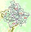 New Municipalities: Đeneral Janković • Gračanica • Junik • Klokot-Vrbovac • Mamuša • Parteš • RanilugCategories:
- Municipalities of Belgrade
- Neighborhoods of Belgrade
- Parks in Belgrade


Wikimedia Foundation. 2010.