- Žabalj
-
Žabalj
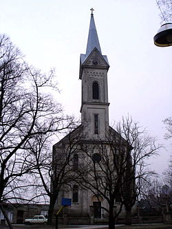
Жабаљ— Municipality and Town — Catholic church in Žabalj 
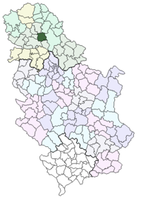
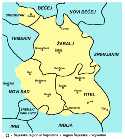
Coat of armsLocation of the municipality of Žabalj within Serbia Coordinates: 45°22′N 20°04′E / 45.367°N 20.067°E Country Serbia District South Bačka Settlements 4 Government – Mayor Branko Stajić Area[1] – Municipality 400 km2 (154.4 sq mi) Population (2011 census)[2] – Town 9,598 – Municipality 27,513 Time zone CET (UTC+1) – Summer (DST) CEST (UTC+2) Postal code 21230 Area code +381 21 Car plates NS Website www.zabalj.biz Žabalj (Жабаљ) pronounced [ʒǎːbaʎ] is a town and municipality in South Bačka District of Vojvodina, Serbia. Žabalj town has a population of 9,582, and Žabalj municipality 27,418. It is located in southeastern part of Bačka, known as Šajkaška.
Contents
Name
Its name came from the Serbian word "žaba" ("frog" in English). In Serbian, the town is known as Žabalj (Жабаљ), in Hungarian as Zsablya or Józseffalva (between 1886 and 1919), in German as Josefdorf, and in Croatian as Žabalj.
History
Žabalj was first mentioned in 1514 as a fortress captured by Doža Đerđ. During the Ottoman rule (16th-17th century), it was populated by ethnic Serbs. In the 18th and 19th century, Žabalj was part of the Habsburg Military Frontier (Šajkaš Battalion). First church in Žabalj was mentioned in 1720, but it was later razed. Present-day church dedicated to Saint Nikolaj was built in 1835. In 1901, the Catholic church was built as well.
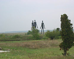
Since 1918, Žabalj was part of the Kingdom of Serbs, Croats and Slovenes and subsequent South Slavic states. During the Hungarian Axis occupation, in 1942 raid, 666 inhabitants of the town were murdered, of whom 355 were men, 141 women, 101 children, and 69 old people. By nationality, victims included 614 Serbs, 28 Jews, 23 Roma, and 1 Hungarian.
Inhabited places
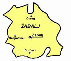
Žabalj municipality encompasses the town of Žabalj, and the following villages:
Ethnic groups (2002 census)
The population of the Žabalj municipality:
- Serbs (86.25%)
- Rusins (5.11%)
- Roma (2.79%)
- Hungarians (1.1%)
All settlements in the municipality have an ethnic Serb majority.
Historical population of the town
- 1961: 7,457
- 1971: 7,851
- 1981: 8,503
- 1991: 8,766
Politics
Seats in the municipal parliament won in the 2004 local elections: [1]
- Serbian Radical Party (12)
- Democratic Party (5)
- Serbian Strength Movement (3)
- Serbian Renewal Movement (2)
- G17 Plus (2)
- Coalition "Victory" (2)
- Alliance of Serbs in Vojvodina (2)
- Socialist Party of Serbia (2)
- Democratic Party of Serbia (1)
See also
- Šajkaška
- South Bačka District
- List of places in Serbia
- List of cities, towns and villages in Vojvodina
References
- Slobodan Ćurčić, Broj stanovnika Vojvodine, Novi Sad, 1996.
- Zvonimir Golubović, Racija u južnoj Bačkoj 1942. godine, Novi Sad, 1991.
- Dr Dušan J. Popović, Srbi u Vojvodini, knjiga 1, Novi Sad, 1990.
References
- ^ "Municipalities of Serbia, 2006". Statistical Office of Serbia. http://webrzs.stat.gov.rs/axd/en/Zip/OG2006webE.zip. Retrieved 2010-11-28.
- ^ "2011 Census of Population, Households and Dwellings in the Republic of Serbia – FIRST RESULTS". Bulletin (Statistical Office of the Republic of Serbia) 540. 2011. ISSN 0354-3641. http://media.popis2011.stat.rs/2011/prvi_rezultati.pdf. Retrieved 2011-11-21.
External links
Municipalities and cities of Serbia Central Serbia Belgrade (Barajevo • Čukarica • Grocka • Lazarevac • Mladenovac • Novi Beograd • Obrenovac • Palilula • Rakovica • Savski Venac • Sopot • Stari Grad • Surčin • Voždovac • Vračar • Zemun • Zvezdara) • Čačak • Jagodina • Kragujevac (Aerodrom • Pivara • Stanovo • Stari Grad • Stragari) • Kraljevo • Kruševac • Leskovac • Loznica • Niš (Crveni Krst • Medijana • Niška Banja • Palilula • Pantelej) • Novi Pazar • Požarevac • Smederevo • Šabac • Užice • Valjevo • Vranje • Zaječar Aleksandrovac • Aleksinac • Aranđelovac • Arilje • Babušnica • Bajina Bašta • Batočina • Bela Palanka • Blace • Bogatić • Bojnik • Boljevac • Bor • Bosilegrad • Brus • Bujanovac • Crna Trava • Čajetina • Ćićevac • Ćuprija • Despotovac • Dimitrovgrad • Doljevac • Gadžin Han • Golubac • Gornji Milanovac • Ivanjica • Kladovo • Knić • Knjaževac • Koceljeva • Kosjerić • Krupanj • Kučevo • Kuršumlija • Lajkovac • Lapovo • Lebane • Lučani • Ljig • Ljubovija • Majdanpek • Mali Zvornik • Malo Crniće • Medveđa • Merošina • Mionica • Negotin • Nova Varoš • Osečina • Paraćin • Petrovac • Pirot • Požega • Preševo • Priboj • Prijepolje • Prokuplje • Rača • Raška • Ražanj • Rekovac • Sjenica • Smederevska Palanka • Sokobanja • Surdulica • Svilajnac • Svrljig • Topola • Trgovište • Trstenik • Tutin • Ub • Varvarin • Velika Plana • Veliko Gradište • Vladičin Han • Vladimirci • Vlasotince • Vrnjačka Banja • Žabari • Žagubica • Žitorađa
Vojvodina  Ada • Alibunar • Apatin • Bač • Bačka Palanka • Bačka Topola • Bački Petrovac • Bečej • Bela Crkva • Beočin • Čoka • Inđija • Irig • Kanjiža • Kikinda • Kovačica • Kovin • Kula • Mali Iđoš • Nova Crnja • Novi Bečej • Novi Kneževac • Odžaci • Opovo • Pećinci • Plandište • Ruma • Sečanj • Senta • Šid • Srbobran • Sremski Karlovci • Stara Pazova • Temerin • Titel • Vrbas • Vršac • Žabalj • Žitište
Kosovo Dečani • Đakovica • Dragaš • Glogovac • Gnjilane • Istok • Kačanik • Klina • Kosovo Polje • Kosovska Kamenica • Kosovska Mitrovica • Leposavić • Lipljan • Mališevo • Novo Brdo • Obilić • Orahovac • Peć • Podujevo • Priština • Prizren • Štimlje • Srbica • Štrpce • Suva Reka • Uroševac • Vitina • Vučitrn • Zubin Potok • Zvečan New Municipalities: Đeneral Janković • Gračanica • Junik • Klokot-Vrbovac • Mamuša • Parteš • RanilugCategories:
- Places in Bačka
- Populated places in Vojvodina
- Municipalities of Vojvodina
Wikimedia Foundation. 2010.

