- Bačka
Bačka (Serbian: Бачка or "Bačka", Hungarian: "Bácska", Croatian: "Bačka", Slovak: "Báčka", Rusyn: Бачка, Bunjevac: "Bačka") is an area of the
Pannonian plain lying between the riversDanube andTisa . It is divided betweenSerbia andHungary , with small uninhabited pockets of land on the left bank of Danube which belong toCroatia , but it's under Serbian control from 1991 ("see disputes of Croatia and Serbia").Most of this area currently forms part of the
Vojvodina region ofSerbia .Novi Sad , the capital city of Vojvodina, stands on the border between Bačka andSyrmia . The smaller northern part of Bačka is now located inBács-Kiskun County in Hungary.Name
The name "Bačka" is Slavic by origin. In Slavic languages, Bačka means "land which belongs to the city of Bač". According to this idea
Hungarians have also adopted this Slavic name for the region.According to the other idea, the denominator of the landscape may have been the first bailiff of "Bács" castle, and the name one which can be rendered probable it old Turkish "baya" derives from a dignity name.
Serbs have also adopted this Hungarian-Turkish name for the region.History
Through history Bačka has been a part of
Dacia , the Hun Empire, the Gepid Kingdom, the Avar Khanate, theFirst Bulgarian Empire , theKingdom of Hungary , theOttoman Empire , theHabsburg Monarchy , theAustrian Empire ,Austria-Hungary , theKingdom of Serbs, Croats and Slovenes , theKingdom of Yugoslavia , theSocialist Federal Republic of Yugoslavia , theFederal Republic of Yugoslavia ,Serbia and Montenegro , and since 2006, it is part of an independentSerbia . The smaller northern part of the region is part of the independentHungary since 1920.People have inhabited the region of Bačka for over 4,000 years, since Neolithic times. The earliest historical inhabitants of the region were probably
Illyria n tribes.Slavs settled today's Bačka in the 6th and 7th centuries. In the 9th century the territory of Bačka was part of
Bulgarian Empire .Salan , aBulgaria n voivod (duke), was a ruler in this territory and his capital city wasTitel . In the early 10th century, Hungarians defeated Salan, and his duchy came under Hungarian rule.In the 11th century, Bacsensis (Bač, Bács) County was formed, with city of Bač as its administrative centre. First known prefect of Bacsensis County was recorded in 1074 and his name was Vid, which is a Slavic name by origin.
In 1526 and 1527, Bačka was the central region of an ephemeral independent Serbian state, which existed in the territory of present-day
Vojvodina . The ruler of this state was the so-called "Emperor" Jovan Nenad and his capital city wasSubotica . After some months the ruler it was overcome, and Bačka got back to theKingdom of Hungary .During the Ottoman rule (16th-17th centuries), Bačka was part of the
Sanjak of Segedin (Szeged), and the region was mainly populated withSerbs . In 1699 the Bačka came into the possession of theHabsburg Monarchy ofAustria . A Bacsensis County was established in the western parts of the region, while the eastern parts of Bačka were incorporated intoTisa -Mureş section of HabsburgMilitary Frontier . After this part of the Military Frontier was abolished in 1751, the eastern parts of Bačka were also included into Bacsensis county. The only part of Bačka which remained within the Military Frontier wasŠajkaška , but it also came under civil administration in 1873.According to the Austrian census from 1715,
Serbs ,Bunjevci (Croats), andŠokci (Croats) comprised most of the region's population. During the 18th century, the Habsburgs carried out an intensive colonisation of the area, which had low population density after the last Ottoman Wars, as much of the Serbian population had been decimated through warfare. The new settlers were primarilySerbs who moved from Serbia into Croatian lands, Hungarians, and Germans. Because many of the Germans came fromSwabia , they were known as "Donauschwaben", orDanube Swabians . Some Germans also came from Austria, and some fromBavaria andAlsace .Lutheran Slovaks , Rusyns, and others were also colonized but to a much smaller extent.There was also an emigration of Serbs from the eastern parts of the region, which belonged to Military Frontier until 1751. After the abolishment of the Tisa-Mureş section of Military Frontier, many Serbs emigrated from north-eastern parts of Bačka. They moved either to
Russia (notably to New Serbia andSlavo-Serbia ) or toBanat , where the Military Frontier was still needed.In 1848 and 1849, Bačka was part of the
Serbian Voivodship , a Serbian autonomous region withinAustrian Empire , while between 1849 and 1860 it was part of theVoivodship of Serbia and Tamiš Banat , a separate Austriancrown land (the official language was German in this time), the successor of the Serbian Voivodship. After 1860, when Voivodship of Serbia and Tamiš Banat was abolished, theBács-Bodrog County was formed in the territory of Bačka. The county was part of theKingdom of Hungary , which became one of two autonomous parts ofAustria-Hungary in 1867.According the 1910 census, the population of Bačka numbers 704.563 people and is composed of: 43,2% Hungarian (310.490), 22,5% German and merely 28,1%-a
Southern Slav .The territory of Bačka (as part of
Banat, Bačka and Baranja region) united with the Kingdom ofSerbia in 1918. By theTreaty of Trianon (4 June 1920 ), the original territory of Bačka was divided between the newly independentHungary and the newly createdKingdom of Serbs, Croats and Slovenes , which was later renamed theKingdom of Yugoslavia . The northern part of the region was a separate county of Hungary (Bács-Bodrog) with seat in Baja, which was later incorporated intoBács-Kiskun county. The southern part of the region was a county ofKingdom of Serbs, Croats and Slovenes between 1918 and 1922, then a province (oblast ) of theKingdom of Serbs, Croats and Slovenes between 1922 and 1929, and in 1929 it was incorporated intoDanube Banovina , which was a province of the Kingdom of Yugoslavia.In 1941 Yugoslav Bačka was occupied by the
Axis powers and attached to Horthy'sHungary . During the occupation, Hungarian troops killed 19,573 civilians in Yugoslav Bačka, mostly of Serb, Jewish and Roma ethnicity, while many more civilians were arrested, violated or tortured. The occupation ended in 1944 with the end of theSecond World War and Yugoslav Bačka became part of the new Democratic Federal Yugoslavia (later the Socialist Federal Republic of Yugoslavia). Following the defeat of the Axis troops, most of the German population that lived in the area left from the region together with German army. The smaller part of the German population that did not leave the area (mostly women, children and the elderly) were sent to prison camps, where the majority died of malnutrition and abuses by the new Yugoslav authorities. Members of the Yugoslav partisan army also killed a certain number of inhabitants of Hungarian and German ethnic origin after the war, mainly as a revenge for genocide and ethnic cleansing that Hungarian troops committed against Yugoslav peoples during the war. The Hungarian victims number in Bačka about 30,000 and the German deaths are estimated to have been approximately 100,000, while many more civilians were arrested, violated or tortured.Together with
Syrmia andBanat , Yugoslav Bačka is part of the Autonomous Province ofVojvodina since 1945. Since 1992, Yugoslav Bačka has been part ofFederal Republic of Yugoslavia (renamed toSerbia and Montenegro in 2003), and since 2006 it is part of an independentSerbia .Geography
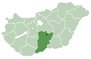
erbian Bačka
The
districts of Serbia in Bačka are:
* West Bačka
* North Bačka
* South BačkaNote that municipalities of
Sremski Karlovci ,Petrovaradin , andBeočin and southern part of municipality ofBačka Palanka that belong to South Bačka District are geographically not located in Bačka, but in Syrmia, while municipalities of Ada,Senta andKanjiža which are geographically located in Bačka are part ofNorth Banat District .Cities and towns in the Serbian part of Bačka (with city population numbers):
*Novi Sad (190,602)
*Subotica (141,471)
*Sombor (50,950)
*Bačka Palanka (29,431)
* Vrbas (25,887)
*Bečej (25,703)
*Senta (20,363)
* Kula (19,293)
*Apatin (19,289)
*Temerin (19,143)
*Futog (18,492)
*Bačka Topola (16,154)
*Srbobran (13,049)
* Ada (10,546)
*Kanjiža (10,193)
*Crvenka (10,153)
*Odžaci (9,832)
*Žabalj (9,582)
*Palić (7,668)
* Mol (6,780)
*Bački Petrovac (6,731)
* Bač (6,046)
*Bački Jarak (6,042)
*Titel (5,831)Note: Senta, Kanjiža, Ada and Mol are geographically located in Bačka, but they are part of the
North Banat District .Also see:
List of inhabited places of Vojvodina Hungarian Bácska
[
 thumb|right|230px|
Bács-Kiskun County withinHungary ] The Hungarian Bácska is mostly located in the Bács-Kiskun county of Hungary, while one small part of the region is located in the Baranya county.Subregions in the Hungarian Bácska include (with population numbers):
* Bajai (76,906)
*Bácsalmás i (18,578)
*Jánoshalma i (17,885)Note that parts of Hungarian Bácska also belong to the subregions of
Kiskunhalas i andMohács i, although the main parts of those subregions are not located in Bácska.Most important towns in Hungarian Bácska (with population numbers):
* Baja (38,143)
*Jánoshalma (9,866)
*Bácsalmás (7,694)Demographics
erbia
According to the 2002
Serbia n census, the population of the Serbian part of Bačka (in geographical borders) numbers 1,022,524 people and is composed of: [Popis stanovništva, domaćinstava i stanova 2002. Knjiga 1: Nacionalna ili etnička pripadnost po naseljima. Republika Srbija, Republički zavod za statistiku Beograd 2003. ISBN 86-84443-00-09]
* 559,700 (54.74%)Serbs
* 221,882 (21.70%) Hungarians
* others (includingSlovaks ,Croats ,Bunjevci (Croats),Šokci (Croats), Rusyns,Montenegrins ,Yugoslavs , Roma,Germans , etc).Hungary
According to the 2001 census in
Hungary , the rough population of the Hungarian Bácska (including districts of Bajai,Bácsalmás i, andJánoshalma i) numbering 113,432 people. [http://www.nepszamlalas.hu/hun/kotetek/06/03/data/tabhun/4/load01_1_0.html] Note that administrative borders of the districts do not fully correspond with the geographical borders of Hungarian Bácska. Most of the inhabitants of Hungarian Bácska are ethnicHungarians . [http://lazarus.elte.hu/hun/maps/ke2500.gif]Gallery
Notes
ee also
*
Vojvodina
*North Bačka District
*West Bačka District
*South Bačka District
*Bács-Bodrog
*Bács-Kiskun External links
* [http://www.backabanat.com backabanat.com]
Wikimedia Foundation. 2010.