- Gornji Milanovac
-
Gornji Milanovac
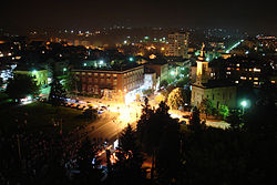
Горњи Милановац— Municipality and Town — Gornji Milanovac at night 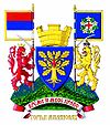
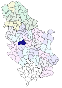
Coat of armsLocation of the municipality of Gornji Milanovac within Serbia Coordinates: 44°01.2691′N 20°27.3572′E / 44.0211517°N 20.4559533°E Country Serbia District Moravica Settlements 63 Government – Mayor Milisav Mirković Area[1] – Municipality 836 km2 (322.8 sq mi) Population (2011 census)[2] – Town 24,048 – Municipality 44,438 Time zone CET (UTC+1) – Summer (DST) CEST (UTC+2) Postal code 32300
32301Area code +381 32 Car plates GM Website www.gornjimilanovac.rs Gornji Milanovac (Serbian: Гoрњи Милановац [gɔ̂ːrɲiː mǐlanɔʋat͡s] (
 listen)) is a town and municipality located in Serbia at 44.012691° North, 20.273572° East. Its name means "Upper Milanovac" (there is a Lower Milanovac, as well) while Milanovac stems from name "Milan" in the Serbian language. The population of town is 24,048.
The city was founded in 1853. Before 1859 the original name of the city was Despotovac, after the Despotovica river passing by the city. In 1859 the name was changed to Gornji Milanovac at the request of the Prince of Serbia Miloš Obrenović.
Contents
Geography
Gornji Milanovac lies between mountains Rudnik to the north and Vujan to the south.
The city is situated along western side of European route E763, between the cities Ljig to the north and Čačak to the south and the villages Majdan to the north and Preljina to the south.
Main city crossroad branches:
- To the North, onto road Gornji Milanovac-Kragujevac (see Kragujevac) that crosses with E763 and turns East; the nearest village on the road is Donja Vrbava.
- To the East, turns South then East through the city, crosses E763 and then goes South through the village of Donja Trepca onto the route 23.
- To the South, towards E763.
- To the West, quickly turns North and after five kilometers branches into road Gornji Milanovac-Cestobrodica (see Cestobrodica) to the West; the nearest village on the road is Takovo, where Takovo Uprising begun; and into road Gornji Milanovac-Gornji Banjani (see Gornji Banjani) to the North; the nearest village on the road is Kalimanici.
South of Milanovac, villages Brdjani to the West and Prislonica to the East are connected to E763 with local roads.
International relations
Twin towns — Sister cities
See also: List of twin towns and sister cities in SerbiaGornji Milanovac is twinned with:
 Mosjøen, Norway
 Kavadarci, Republic of Macedonia
 Slovenj Gradec, Slovenia
 Edessa, Greece
 Pleven, Bulgaria
Gallery
References
- ^ "Municipalities of Serbia, 2006". Statistical Office of Serbia. http://webrzs.stat.gov.rs/axd/en/Zip/OG2006webE.zip. Retrieved 2010-11-28.
- ^ (in Serbian) Popis stanovništva, domaćinstava i Stanova 2002. Knjiga 1: Nacionalna ili etnička pripadnost po naseljima. Statistical Office of Serbia. 2003. ISBN 86-84443-00-09. May be downloaded from: [1]
External links
- Official site
- GM032.net Internet Portal of the Municipality of Gornji Milanovac
- Tourist Organisation of the Municipality of Gornji Milanovac
- GornjiMilanovac.org internet Portal
Categories:- Populated places in Moravica District
- Šumadija
- Municipalities of Central Serbia
- Moravica District geography stubs
Wikimedia Foundation. 2010.

