- Vračar
Infobox Settlement
official_name = Vračar
other_name =Vracar
native_name =Врачар
nickname =
settlement_type = Municipality
motto =
imagesize =
image_caption =
flag_size =
image_
seal_size =
image_shield = Vracar coa.jpg
shield_size =
image_blank_emblem =
blank_emblem_type =
blank_emblem_size =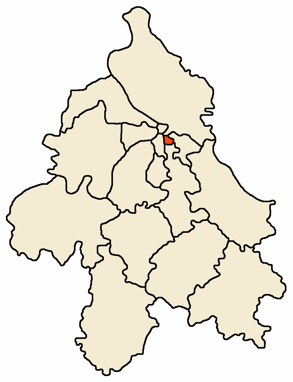
mapsize = 100px
map_caption = Location within the City of Belgrade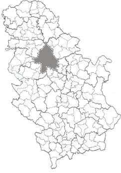
mapsize1 = 100px
map_caption1 = Location within Serbia
image_dot_
dot_mapsize =
dot_map_caption =
dot_x = |dot_y =
pushpin_
pushpin_label_position =
pushpin_map_caption =
pushpin_mapsize =
subdivision_type = Country
subdivision_name =Serbia
subdivision_type1 = City
subdivision_name1 =Belgrade
subdivision_type2 = Status
subdivision_name2 = Urban
subdivision_type3 = Settlements
subdivision_name3 = 1
subdivision_type4 =
subdivision_name4 =
government_footnotes =
government_type =Municipality of Belgrade
leader_title =Mun. president
leader_name =Branimir Kuzmanović (DS)
leader_title1 =
leader_name1 =
leader_title2 =
leader_name2 =
leader_title3 =
leader_name3 =
leader_title4 =
leader_name4 =
established_title =
established_date =
established_title2 =
established_date2 =
established_title3 =
established_date3 =
area_magnitude =
unit_pref =
area_footnotes =
area_total_km2 =3
area_land_km2 =
area_water_km2 =
area_total_sq_mi =
area_land_sq_mi =
area_water_sq_mi =
area_water_percent =
area_urban_km2 =
area_urban_sq_mi =
area_metro_km2 =
area_metro_sq_mi =
area_blank1_title =
area_blank1_km2 =
area_blank1_sq_mi =
population_as_of =2002
population_footnotes =
population_note =
population_total =58,386
population_density_km2 =
population_density_sq_mi =
population_metro =
population_density_metro_km2 =
population_density_metro_sq_mi =
population_urban =
population_density_urban_km2 =
population_density_urban_sq_mi =
population_blank1_title =
population_blank1 =
population_density_blank1_km2 =
population_density_blank1_sq_mi =
timezone = CET
utc_offset = +1
timezone_DST =CEST
utc_offset_DST = +2
latd= |latm= |lats= |latNS=
longd= |longm= |longs= |longEW=
elevation_footnotes =
elevation_m =
elevation_ft =
postal_code_type = Postal code
postal_code =11000
area_code =+381 11
blank_name =Car plates
blank_info =BG
blank1_name =
blank1_info =
website = [http://www.vracar.org.yu/ http://www.vracar.org.yu/]
footnotes =Vračar (Serbian
Cyrillic : Врачар) is an urban neighborhood and one of 17 municipalities which constitute the City of Belgrade, the capital ofSerbia . With an area of only convert|297|ha|acre|0|lk=on, it is the smallest of all Belgrade's (and Serbian) municipalities, but also the most densely populated.Neighborhood
Location
The neighborhood of Vračar is located on the top of the Vračar plateau, partially in the easternmost section of the municipality of
Savski Venac as a result of a series of administrative changes of municipal boundaries after theWorld War II . Despite its small area, being located less than a kilometer away from downtown (Terazije ) it borders many other Belgrade neighborhoods: the square and neighborhood ofSlavija to the north, Palilula to the northeast,Čubura andGradić Pejton to the east,Neimar to the south and the park and neighborhood ofKarađorđev Park to the southwest. Vračar plateau is one of the highest points in downtown BelgradeHistory
Name Vračar (derived from Serbian word "vrač" meaning the '
medicine man ', 'healer') was mentioned for the first time in 1495 in Turkish documents. In 1560 it is mentioned as the Christian village outside the fortress ofKalemegdan with 17 houses. It is believed this village is the place where in 1595 the Turkishgrand vizier Sinan Pasha burned at the stake the remains ofSaint Sava , a major Serbian saint, to pacify and punish a rebellious population.At the beginning of the XIX century Vračar, as a geographical term, referred to a much wider area, from the village of
Savamala (present Mostar) on the west to the village of Paliula (present neighborhood ofKaraburma ), which means it used to cover at least three times larger territory than the municipality covers today. By order of princeMiloš Obrenović , an alternative city centre with western characteristics was designed and built here while city of Belgrade was still under Turkish rule and for three quarters an oriental town with all the characteristics ofIslamic architecture . On the other hand, Vračar was built with broad streets and boulevards, first parks and monuments. It was housing all Serbian public buildings and state institutions."
The Times " onOctober 17 ,1843 published a text full of exultations. 'Four years have passed since the time when I was last here, and how Belgrade has changed! I have hardly recognised it. The high belfry on the church (Cathedral) now screens by its shadow the Turkish mosques; many shops are now provided with new doors and glass windows, oriental clothing is more rare and houses with several storeys, inEurope an manner, are being built everywhere'.Many architects-baumeisters (builders) Germans, Czechs, Italians and the Serbians who appeared only at the end of the 1860s built new Serbian Belgrade in Vračar. After 1867, when Turkish military garrisons left the Belgrade fortress Kalemegdan they extended their architectural activities on the ruins of the Turkish houses (
Stambol gate ,Dorćol , Palilula) and on the ruins of the Serbian huts in theSava river port, Savamala.Since 1880s, the neighborhood was roughly divided into
Zapadni Vračar (West Vračar) andIstočni Vračar (East Vračar), divided by the road of "Šumadijski put" (present Boulevard of Liberation). Since 1955 when municipality was officially split into these two, Zapadni Vračar later became core of the new municipality ofSavski Venac while the term Vračar became synonym for Istočni Vračar only.Characteristics
The most dominant feature of modern Vračar is the massive
Temple of Saint Sava . Its decades long, troubled construction shaped not just the present appearance of the plateau, but also the skyline of the entire Belgrade. Plateau has been reshaped in the early 2000s, with fountains, marble access roads to the temple with pillars and children playgrounds added, while the already existing monument to the leader of theFirst Serbian Uprising ,Karađorđe , was erected on a low, artificial hillock. Plateau is also the location of the National Library of Serbia and Karađorđev Park also begins here, while the craftsmen settlement of Gradić Pejton and the bohemian quarter of Čubura nearby.Municipality
Location
Small municipality of Vračar borders other five Belgrade municipalities:
Voždovac to the south,Zvezdara to the east, Palilula to the northeast, Stari Grad to the north and Savski Venac to the west. It is generally bounded by the three boulevards: Boulevard of Liberation, Southern Boulevard and the Boulevard of King Aleksandar.Geography
The
Vračar plateau is on of the highest point in downtown Belgrade, which is generally built on a hilly terrain (32 hills altogether). Almost no geographical features survive today as the area is completely urbanized, except for the small section of Karađorđev Park on the southern slopes of the plateau. Some much larger parks, like major portion of Karađorđev Park or parks Manjež andTašmajdan are left just outside the Vračar's administrative borders.Administration
The municipality of Vračar was officially formed in 1952 after Belgrade was administratively reorganized from districts ("rejon") to municipalities. Already on
September 1 ,1955 Vračar was divided into Zapadni Vračar and Istočni Vračar. Year and a half later, onJanuary 1 1957 , parts of Istočni Vračar merged with the municipality of Neimar and the western part of the municipality of Terazije to create new, albeit the smallest one municipality in Belgrade. Zapadni Vračar became municipality of Savski Venac, while the easternmost section of Istočni Vračar became part of the municipality of Zvezdara (local community ("mesna zajednica") of Vračarsko Polje; Zvezdara hill itself was styled "Veliki Vračar" - Big Vračar).Recent presidents of the municipal assembly:
* January 1993 - December 1996;
Dragan Maršićanin (b. 1950)
* December 1996 -June 13 ,2006 ; Milena Marković (b. 1950)
*June 13 ,2006 - present; Branimir Kuzmanović (b. 1968)Mrs Dunja Vlahović (b. 1912), who was municipal president from January 1957 when Vračar was restored as one municipality, was one of the first female municipal presidents in Serbia.
District (Serbian: "srez") which comprised the suburban area of Belgrade after 1945 was called Vračar District ("Vračarski srez") though the name Belgrade District was also used. In 1955 the Vračar District merged with the City of Belgrade and parts of some bordering districts to create new, enlarged Belgrade District.
Population
As the other two central Belgrade municipalities, Stari Grad and Savski Venac, Vračar has been depopulating for the last five decades. Despite that, Vračar is thanks to its small area, by far the most densely populated municipality of Belgrade, with 19.659 inhabitants per square kilometer (2002 census; 29,772 back in 1971). Population of Vračar:
* 1961 census - 88,422
* 1971 census - 84,291
* 1981 census - 78,862
* 1991 census - 67,438
* 2002 census - 58,386
* 2005 estim. - 56,197If the pre 1955 administrative division remained, population of the municipality would be 91,539 in 2002.
Ethnic structure
2002 census:
*
Serbs : 51,089 (87.50%)
*Montenegrins : 1,167 (1.99%)
*Yugoslavs : 1,031 (1.76%)
*Croats : 390 (0.66%)Neighborhoods
As Vračar has a very small area by itself, its sub-neighborhoods are also small, some of them encompassing only a street or so:
Characteristics
Vračar is a residential and very important commercial part of Belgrade. The talled
skyscraper in downtown Belgrade, theBeograđanka , Cvetni Trg (famous for its flower shops) and the square of Slavija occupy the western section of the municipality. Other important features are theTemple of Saint Sava and theNational Library of Serbia on the Vračar plateau, northern section of the biginterchange Autokomanda and the stadium of theFK Obilić (Miloš Obilić Stadium ) and the Architecture high school in the extreme west of the municipality. Commercial center of the municipality is the area surrounding the Kalenić, largest open green market in Belgrade.International cooperation
Vračar is twinned with following cities and municipalities [ [http://www.skgo.org/php/opstine/detalji.php?Id=63&IdSvojstva=MO] "Stalna konferencija gradova i opština". Retrieved on
2007-06-18 .] :
*flagicon|GreeceAnavyssos ,Greece Historical references
*"Beograd - Izdanje opštine beogradske", 1911;
*"Zapisi starog Beograđanina" 2000;
*"Iz starog Beograda", Živorad P. Jovanović 1964;
*"Siluete starog Beograda", Milan Jovanović - Stojimirović, 1971;
*"Uspon Beograda", Milivoje M.Kostić, 2000;
*"Beogradske gradske pijace", JKP Beogradske pijace, 1999;
*"Vračarski glasnik", 1997-2004See also
*
Istočni Vračar
*Zapadni Vračar
*Subdivisions of Belgrade
*List of Belgrade neighborhoods and suburbs References
External links
* [http://www.vracar.org.yu/ Vračar municipality]
* [http://www.beograd.org.yu/cms/view.php?id=2106 Vračar presentation at the official Belgrade site]
Wikimedia Foundation. 2010.