- Sečanj
-
Sečanj
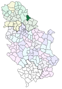
Сечањ— village — The new Orthodox church. Location of the municipality of Sečanj within Serbia Coordinates: 45°22′N 20°46′E / 45.367°N 20.767°E Country Serbia District Central Banat Settlements 11 Government – Mayor Predrag Milošević Area[1] – Municipality 523 km2 (201.9 sq mi) Population (2011 census)[2] – Town 2,647 – Municipality 16,377 Time zone CET (UTC+1) – Summer (DST) CEST (UTC+2) Postal code 23240 Area code +381 23 Car plates ZR Sečanj (Сечањ) is a village and municipality in Central Banat District of Vojvodina, Serbia. The village has a population of 2,645, while the Sečanj municipality has 16,298 inhabitants.
Contents
Name
"Sečanj" is a Slavic name for the first month in the calendar year. The Serbian Ekavian variant of this name was eventually replaced with the new word "Januar" (corresponding to the common months as known in Western European cultures), while the Croatian Ijekavian variant "Siječanj" remains in use in Croatia.
In Serbian, the village is known as Сечањ or Sečanj, in Hungarian as Szécsány or Torontálszécsány, in German as Setschan or Petersheim, in Croatian as Sečanj, and in Romanian as Seceani.
Serbian, Hungarian, and Romanian language are officially used by municipal authorities.
Historical population of the village
- 1837: 1,489
- 1900: 2,596
- 1961: 2,829
- 1971: 2,906
- 1981: 2,718
- 1991: 2,688
Inhabited places
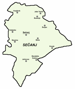
The Sečanj municipality includes the town of Jaša Tomić and the following villages:
- Sečanj
- Banatska Dubica
- Boka
- Busenje (Hungarian: Káptalanfalva)
- Jarkovac
- Konak (Hungarian: Kanak)
- Krajišnik
- Neuzina (Hungarian: Nezsény)
- Sutjeska (Hungarian: Szárcsa)
- Šurjan (Hungarian: Surján)
Ethnic groups (2002 census)
The population of the Sečanj municipality:
- Serbs = 11,607 (70.87%)
- Hungarians = 2,068 (12.63%)
- Romanians = 642 (3.92%)
- Roma = 609 (3.72%)
- Yugoslavs = 266 (1.62%)
- Croats = 148 (0.9%)
- Bulgarians = 114 (0.7%)
The settlements with Serb ethnic majority are: Sečanj, Banatska Dubica, Jarkovac, Jaša Tomić, Krajišnik, and Sutjeska. The settlement with Hungarian ethnic majority is Busenje. Ethnically mixed settlements with relative Serb majority are: Konak, Neuzina, Boka and Šurjan.
References
- Slobodan Ćurčić, Broj stanovnika Vojvodine, Novi Sad, 1996.
- Msgr. Erős Lajos, Adalékok a Zrenjanini-Nagybecskereki Egyházmegye történetéhez, 1993. (Additamenta ad historiam Diocesis Zrenjaninensis-Nagybecskerekensis)
- ^ "Municipalities of Serbia, 2006". Statistical Office of Serbia. http://webrzs.stat.gov.rs/axd/en/Zip/OG2006webE.zip. Retrieved 2010-11-28.
- ^ "2011 Census of Population, Households and Dwellings in the Republic of Serbia – FIRST RESULTS". Bulletin (Statistical Office of the Republic of Serbia) 540. 2011. ISSN 0354-3641. http://media.popis2011.stat.rs/2011/prvi_rezultati.pdf. Retrieved 2011-11-21.
See also
Coordinates: 45°22′13″N 20°47′43″E / 45.370177°N 20.795403°E
Cities, towns and villages in the Central Banat District Zrenjanin: Aradac • Banatski Despotovac • Belo Blato • Botoš • Elemir • Ečka • Jankov Most • Klek • Knićanin • Lazarevo • Lukino Selo • Lukićevo • Melenci • Mihajlovo • Orlovat • Perlez • Stajićevo • Taraš • Tomaševac • Farkaždin • Čenta
Žitište: Banatski Dvor • Banatsko Višnjićevo • Banatsko Karađorđevo • Međa • Novi Itebej • Ravni Topolovac • Srpski Itebej • Torak • Torda • Hetin • Čestereg
Nova Crnja: Aleksandrovo • Vojvoda Stepa • Radojevo • Srpska Crnja • Toba
Novi Bečej: Bočar • Kumane • Novo Miloševo
Sečanj: Banatska Dubica • Boka • Busenje • Jarkovac • Jaša Tomić • Konak • Krajišnik • Neuzina • Sutjeska • Šurjan
(*) bold are municipalitiesCategories:- Vojvodina geography stubs
- Places in Serbian Banat
- Populated places in Vojvodina
- Municipalities of Vojvodina
Wikimedia Foundation. 2010.


