- South Bačka District
-
Južnobački okrug
Јужнобачки округ— District of Serbia — Location of South Bačka District in Serbia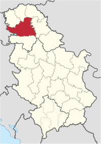
Country  Serbia
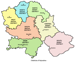
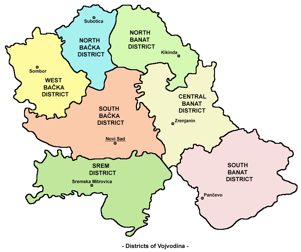
Capital Novi Sad Government – Commissioner Obrad Milošević [1] Area – Total 4,016 km2 (1,550.6 sq mi) Population (2002 census) – Total 593,666 – Density 147.8/km2 (382.8/sq mi) Municipalities 11 and 1 city Settlements 77 - Cities and towns 16 - Villages 61 South Bačka District (Serbian: Јужнобачки округ, Južnobački okrug) is a northern district (okrug) of Serbia. It lies in the southern part of Bačka and northern part of Syrmia, in the autonomous province of Vojvodina. It has a population of 593,666. The main city and seat of the district is Novi Sad, which is also the capital and the largest city of the Autonomous Province of Vojvodina.
Contents
Name
In Serbian, the district is known as Južnobački okrug (Јужнобачки округ), or in official documents, the name may also be spellt Južno-Bački okrug (Јужно-Бачки округ). In Croatian it is known as Južnobački okrug; in Hungarian as Dél-bácskai körzet; in Slovak as Juhobáčsky okres; in Romanian as Districtul Bacica de Sud and in Rusyn, a Cyrillic-based script: Јужнобачки окрух.
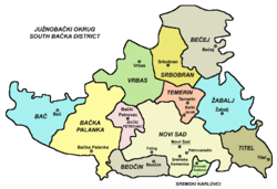
Municipalities
District is divided into 11 municipalities and City of Novi Sad, which is divided into two urban municipalities.
The municipalities are:
- Srbobran
- Bač
- Bečej (Hungarian: Óbecse)
- Vrbas
- Bačka Palanka
- Bački Petrovac (Slovak: Báčsky Petrovec)
- Žabalj
- Titel
- Temerin
- Beočin
- Sremski Karlovci
City of Novi Sad is divided into municipalities of:
Note: for municipalities with Hungarian and Slovak relative or absolute majority names are also given in these languages.
Settlements
 South Bačka (Južna Bačka) District within Vojvodina
 Map of South Bačka District
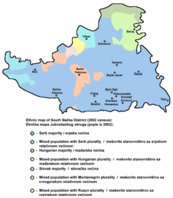 Ethnic map of South Bačka District
There are 76 towns and villages, and 1 city in South Bačka. The largest settlements in the district are (with population figures):
- Novi Sad (283,634) (2009)
- Bačka Palanka (31,494) (2008)
- Vrbas (26,484) (2008)
- Bečej (25,840) (2008)
- Temerin (20,903) (2008)
- Futog (20,491) (2008)
Ethnic groups
District population is composed of:
- Serbs (69.06%)
- Hungarians (9.28%)
- Slovaks (4.65%)
- Montenegrins (2.92%)
- Yugoslavs (2.68%)
- Croats (2.02%)
- Rusyns (1.25%)
- Roma (1.01%)
- Others
There are 8 municipal areas with Serbian ethnic majority: City of Novi Sad (75%), Sremski Karlovci (76%), Titel (85%), Žabalj (86%), Beočin (68%), Srbobran (67%), Bačka Palanka (78%) and Temerin (64%).
One municipality in the district has a Slovak majority: Bački Petrovac or Báčsky Petrovec in Slovak (66%), and 3 are mixed: Vrbas, with relative Serb majority (48%), Bač, with relative Serb majority (46%) and Bečej or Óbecse in Hungarian, with relative Hungarian majority (49%).
Culture
The first Serbian primary school was founded in Bečej in 1703, while the first grammar school was established in Sremski Karlovci in 1791.
Novi Sad is home to the oldest cultural and scientific institution of the Serbian people - the Matica Srpska, which was founded in 1826 in Budapest, and transferred to Novi Sad in 1864. The Serbian National Theatre was founded in Novi Sad in 1861.
Economy
Within the district the following industries prevail: chemical, oil, machines, tools and electrical porcelain, textile, food, and construction industry.
Administration
By the Serbian government's 2006 Regulation of the administrative districts [2] the names of all districts were changed from okrug (district) to upravni okrug (administrative district). District is governed by the prefect (načelnik) who is appointed by the central government. Prefects of the South Bačka District were:
- 19?? - 1997: Jovo Ubibarip
- 1997 - April 12, 2001: Obrad Milošević
- April 12, 2001 - June 28, 2002: Arsen Kurjački (b.1958)
- June 28, 2002 - April 29, 2004: Branko Bjelajac
- April 29, 2004 - November 3, 2005: Darko Mandić
- November 3, 2005 - July 6, 2007: Svetlana Selaković (b.1957)
- July 6, 2007 - present: Darija Šajin (b.1973)
References
External links
Official municipality sites:
- Official site of Bač municipality
- Official site of Bačka Palanka municipality
- Official site of Bački Petrovac municipality
- Official site of Beočin municipality
- Official site of Bečej municipality
- Official site of Vrbas municipality
- Official site of Žabalj municipality
- Official site of Novi Sad
- Official site of Srbobran municipality
- Official site of Temerin municipality
- Official site of Titel municipality
- Official site of Sremski Karlovci municipality
Districts of Serbia Vojvodina Central Serbia Kosovo and Metohija1 Kosovo • Kosovo-Pomoravlje • Kosovska Mitrovica • Peć • Prizren1 Sovereignty disputed with the Republic of Kosovo. These are the districts recognized by the Republic of Serbia. For the districts recognized by the Republic of Kosovo, see Districts of Kosovo.Note: All official material made by Government of Serbia is public by law. Information was taken from official website.
Categories:


Wikimedia Foundation. 2010.