- Military Frontier
-
Military Frontier
Militärgrenze
Vojna granica / Vojna krajina
Војна граница / Војна крајина
Graniţă militară
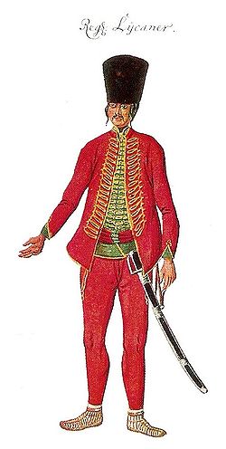
Határőrvidékmilitary province of the Habsburg Monarchy 16th century–1882 History - Established 16th century - Disestablished 1882 Today part of Croatia, Serbia, Romania, Hungary, Bosnia and Herzegovina, Slovenia 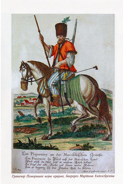 Frontiersman from Pomorišje, first half of the 18th century.
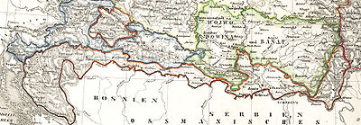
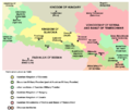
The Military Frontier (also known as Military Border and Military Krajina; Croatian: Vojna granica, Vojna krajina; Slovene: Vojna krajina; Serbian: Vojna granica / Војна граница, Vojna krajina / Војна Крајина; German: Militärgrenze; Hungarian: Határőrvidék; Romanian: Graniţă militară) was a borderland of Habsburg Austria and later the Austro-Hungarian Monarchy, which acted as the cordon sanitaire against incursions from the Ottoman Empire. When created in the 16th century by Ferdinand I, it was divided into two districts each under its own special military administration: the Croatian Military Frontier and the Slavonian Military Frontier. Both of these, along with all later military districts, were placed under the unified control of the Croatian General Command in 1783.[1] The Military Frontier was a separate Habsburg administrative unit, directly subordinated to Vienna. Its territory stretched from central Croatia in the west to eastern Transylvania in the east and included parts of present-day Croatia, Serbia, Romania and Hungary.
Contents
History
Ottoman wars
The Ottoman wars in Europe caused the border of the Kingdom of Hungary and subsequently the Habsburg Monarchy to shift towards northwest. Much of the old Croatian territory was either captured by the Ottomans or bordered the new Ottoman domain.
In 1435, in an attempt to strengthen the defences towards the Ottomans and Venice, the king Sigismund founded the so-called tabor, a military encampment, each in Croatia, Slavonia and Usora. In 1463, the king Matthias Corvinus founded the banovina of Jajce and Srebrenik, and in 1469 the military captaincy of Senj, modeled after the Ottoman captaincies in the Province of Bosnia. All these actions were intended to provide for better defences, but were ultimately unsuccessful. It did bring forth the Croatian Pandur infantry and the Serbian Hussar cavalry though.
After 1526, the Austrian Habsburgs were selected by the Croatian Parliament as kings of Croatia, and Emperor Ferdinand promised the Croatian Parliament that he would give them 200 cavalrymen and 200 infantrymen, and that he would pay for another 800 cavalrymen who would be commanded by the Croatians. Soon the Habsburg Empire founded another captaincy in Bihać. In the short term, all this was also ineffective, as in 1529 the Ottomans swept through the area, captured Buda and besieged Vienna, wreaking havoc throughout the Croatian border areas.
In 1553, the borderland was reformed for the first time, under the commander Ivan Lenković. The frontier was split into the Croatian Krajina (Krabatische Gränitz) and the Upper Slavonian Krajina (Windische, Oberslawonische Gränitz). The border with the Ottoman Empire on the line Senj-Otočac-Slunj-Glina-Hrastovica-Sisak-Ivanić-Križevci-Đurđevac was fortified with several smaller and larger forts. New captaincies were formed in the larger forts: Ogulin, Hrastovica, Žumberak, Koprivnica, Križevci and Ivanić. Smaller forts were manned by German infantry and Croatian light infantry. The larger forts were manned by German heavy cavalry and Croatian light cavalry.
The new military expenditures became a considerable concern, and the Congress of Inner Austrian lands in Bruck an der Mur in 1578 defined the obligations of each land in covering the military expenses and defined the priorities in improving the defensive strategy. The nobility of Styria financed the Upper Slavonian Frontier while the others (Lower Austria, Upper Austria, Carniola, Carinthia and Salzburg) financed the Croatian Frontier.
By the end of the 16th century the Croatian Krajina became known as the Karlovac generalat, and since the 1630s the Upper Slavonian Krajina was known as the Varaždin generalat. During the 16th and 17th century, the military administration of the Frontier was moved away from the Croatian ban and the Sabor (Parliament) and instead instated in the high command of Archduke Charles and the War Council in Graz.
Despite the financial support of the Inner Austrian nobility, the financing of the Military Frontier was not efficient enough. The military leadership in Graz decided to try solutions other than mercenary units. In the 1630s, the Imperial Court decided to give land and certain privileges to immigrants into the Frontier (the uskok guerrillas as well as refugees from Ottoman-controlled lands) at the area of Žumberak, and in return they would serve in the Imperial army. The remaining local population was also encouraged to stay by receiving the status of free peasants (rather than serfs) and other privileges. These new units were organized into ten or more voivodeships per each captaincy.
In November 1630, the Emperor proclaimed the so-called Statuta Wallachorum or Vlach Statute [1], which regulated the status of so-called Vlach settlers (which included Croats, Serbs and Vlachs) from the Ottoman Empire with regard to military command, their obligations and rights to internal self-administration. Over time, the population of the Frontier (as it was then) became mixed between the autochthonous Croats and Croatian serfs who had fled the Ottoman territories, and the numerous minority of Serb and Vlach (who were later assimilated into Croats and Serbs) refugees who strove to expand their rights as a major contributor in the defense of the land. By creating the new military class in the Frontier, the territory of the Frontier eventually became fully detached from the Croatian Parliament and the ban. The Territory of the Frontier had a large Serb population, who fled from their south-eastern lands, and tried to fight the Ottoman forces, making a refuge in Habsburg Croatia. As freedom of faith was granted to them, the Orthodox faith was preserved in spite of their living in a Catholic country. Eventually, the whole population of the Military Frontier became professional soldiers that served an Empire on several fronts and through many European wars, even after the disappearance of Ottoman threat.
In 1673 the first detailed map of the Military Frontier was released, where the funfair and the public bath for border guard officers and other gentlemen from the neighborhood in Miholjanec was marked.[2] Their wives and children lived together in organized agricultural cooperatives.
After the Great Turkish War and Treaty of Karlowitz
The 17th century was a relatively peaceful period, during which only smaller raids were made from the Province of Bosnia. After the Ottoman army was repelled at the Battle of Vienna in 1683, the Great Turkish War ended with much of the former Croatian lands under Habsburg control. Despite this, the Frontier system was retained, and expanded onto former Ottoman territories in Lika, Kordun, Banija, lower Slavonia, Syrmia, Bačka, Banat, Pomorišje, and Transylvania. The Empire valued the ability to centrally control the area and draft cheap and numerous army units.
After the Treaty of Karlowitz of 1699, a unit called the Serežan troop was formed, and it had both military and police duties. The members were not paid, but were released of all taxes. As an irregular unit, they wore a folk uniform rather than an army one. Over the following century, each regiment had one section of the serežani, led by a oberbaša or harambaša (sergeant), several unterbaša (corporal) and vicebaša (lance corporal). They organized the border patrols towards Bosnia, particularly on difficult terrain, and stopped incursions of bandits. They had to have extensive knowledge of the territory, good marksmanship and to be constantly under arms. They also maintained public law and order in the area of their regiment. There were also cavalry serežan units that served as escort to the high officers of Frontier regiments, carried urgent orders and carried out special patrol duties.
From 1718 to 1739, Military Frontier also included Habsburg-controlled northern parts of present-day Bosnia and Herzegovina.[3]
In mid-18th century, the Frontier was once again reorganized and modelled after the Imperial army and its regular regiments. In 1737, the Vlach Statute was formally abolished. All previous captaincies and voivodships were discarded, and the area was instead subdivided into general-commands, regiments and companies:
- Varaždin general command
- Križevci regiment
- Đurđevac regiment
- Karlovac general command
- Zagreb general command
- Slavonia general command
- Gradiška regiment
- Brod regiment
- Petrovaradin regiment
- Banat general command
- Serb (Illyrian) section
- German section
- Romanian (Vlach) section
After 1767, every twelfth inhabitant of the Military Frontier was a soldier, while in the rest of the Habsburg Monarchy only every 62nd inhabitant was one. The Frontier soldiers became professional military, ready to move to all European battlefields. Due to further immigration of refugees from the Ottoman domain, and the expansion of the territory to places previously controlled by the Ottomans, the population of the Frontier became even more mixed. There were still many autochthonous Serbs and Croats in Slavonia and parts of present-day Vojvodina (in Syrmia, Bačka and Banat). However, at this time they became outnumbered by the Serb, Croat and Vlach refugees/immigrants. Some Germans and Magyars also came to the Frontier, mostly as administrative personnel, and there was a number of other settlers and military persons from other parts of the Habsburg Empire such as the Czechs, Slovaks, Ukrainians, Rusyns and others.
In 1787, the civil administration was separated from the military, but this was reversed in 1800. By the Basic Law of the Frontier from 1850, the administration of Military Frontier was split and the land started to look like a state. The Main Command was headquartered in Zagreb, but still directly subordinate to the Ministry of War in Vienna.
Abolishment of the frontier
The Croatian Parliament made numerous pleas to demilitarize the Frontier after the Turkish wars subsided. The demilitarization began in 1869 and on August 8, 1873, under Franz Joseph, the Banatian Frontier was abolished and incorporated into the Kingdom of Hungary, while part of Croatian Frontier (Križevci and Đurđevac regiments) was incorporated into Croatia-Slavonia. The decree in which the rest of Croatian and Slavonian Frontiers were incorporated into Croatian-Slavonian crownland was proclaimed on July 15, 1881, while incorporation was performed in 1882.
Population
1790
According to 1790 data, the population of the Military Frontier was composed of:[4]
- Serbs = 388,000 (42.4%)
- Croats = 325,000 (35.5%)
- Romanians = 89,000 (9.7%)
- Hungarians = 69,000 (7.5%)
- Germans = 44,000 (4.8%)
By religion, the population included (1790 data):[5]
- Orthodox Christians = 473,000 (51.7%)
- Catholics = 414,000 (45.2%)
- Calvinists = 28,000 (3.1%)
1850
In 1850, the population of the Military Frontier numbered 958,877 inhabitants, of whom 54% were Orthodox Christians.[6]
Divisions
In the 18th and 19th centuries, the frontier was divided into the several districts:
Danube Military Frontier
This section of the Military Frontier existed in the first half of the 18th century and comprised parts of southern Bačka (including Palanka, Petrovac, Petrovaradinski Šanac, Titel, etc.) and northern Syrmia (including Petrovaradin, Šid, etc.). After the abolishment of this section of the Frontier, one part of its territory was placed under civil administration and another part was joined to other sections of the Frontier.
Tisa Military Frontier
This section of the Military Frontier existed between 1702 and 1751 and comprised parts of north-eastern Bačka (including Sombor, Subotica, Kanjiža, Senta, Bečej, etc.). After the abolishment of this section of the Frontier, most of its territory was placed under civil administration, while one small area in the south remained under military administration as part of the Šajkaš Battalion.
Mureş Military Frontier
This section of the Military Frontier existed between 1702 and 1751 and comprised the region of Pomorišje (area on the northern bank of the river Mureş). After the abolishment of this section of the Frontier, its entire territory was placed under civil administration.
Sava Military Frontier
It existed in the first half of the 18th century along the Sava river.
Banat Military Frontier
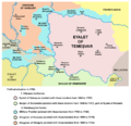
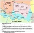
The Banat Krajina was located on the Serbian-Romanian border. It was divided into Serbian (Illyrian), German (Volksdeutscher) and Romanian (Vlach) sections.
Slavonian Military Frontier
The Slavonian Krajina was located along Posavina, from eastern Croatia, following the river Sava, along the border with Bosnia-Herzegovina and Serbia, and stretched into Syrmia, till inflow into Danube near Zemun (today part of Belgrade). Its north-eastern border followed the Danube up till the Petrovaradin.
Croatian Military Frontier
The Croatian Military Frontier or "Banska krajina" was located on the border of Croatia and Bosnia.
This part of the Military Frontier included the geographic regions of Lika, Kordun, Banovina (named after "Banska krajina"), and bordered the Adriatic Sea to the west, Venetian Republic to the south, Habsburg Croatia to the west, and the Ottoman Empire to the east.
It extended onto the Slavonian Krajina near the confluence of the rivers Una and Sava.
Šajkaš Battalion
The Šajkaš Battalion was a small part of the Frontier that was formed in 1763 from parts of the previously abolished Danube and Tisa sections of the frontier. In 1852, Šajkaš battalion was transformed into Titel infantry battalion. It was abolished in 1873, and its territory was incorporated into Bačka-Bodrog County.
Transylvanian Military Frontier
Transylvanian Military Frontier existed from 1762 to 1851, mostly in eastern and southern parts of Transylvania. It was composed of two Székely and two Romanian regiments. The establishment of the frontier was followed by the Mádéfalva Massacre or Siculicidium.
Legacy
After the former Yugoslav Republic of Croatia declared independence (in 1991), the Serbs who lived in the region of former Military Frontier (Vojna Krajina) adopted that name (Krajina) in the name of the Republic of Serbian Krajina. However, this Serb entity also included some territories that were not part of the Military Frontier in the past, while large tracts of territory that had constituted the Military Frontier resided outside the Serb region as largely Croat populated areas of the Republic of Croatia (See the Croatian War of Independence for more information).
See also
References
- ^ Fine, pp.370-471.
- ^ Geoadria, Year: 2001, Volume: 6, Issue: 1, Pages/record No.: 81-91, Hrvatsko geografsko društvo - Zadar, Odjel za geografiju, Sveučilište u Zadru, 2001., ISSN 1331-2294
- ^ Empires and Peninsulas: Southeastern Europe Between Carlowitz and the Peace of Adrianople, 1699-1829, Plamen Mitev, Plamen Mitev, Ivan Parvev, Maria Baramova, Vania Racheva, LIT Verlag Münster, 2011, page 171.
- ^ Peter Rokai - Zoltan Đere - Tibor Pal - Aleksandar Kasaš, Istorija Mađara, Beograd, 2002, pages 376-377.
- ^ Peter Rokai - Zoltan Đere - Tibor Pal - Aleksandar Kasaš, Istorija Mađara, Beograd, 2002, page 377.
- ^ Dr Tomislav Bogavac, Nestajanje Srba, Niš, 1994, page 196.
Further reading / Bibliography
- John Van Antwerp Fine, When ethnicity did not matter in the Balkans: a study of identity in pre-nationalist Croatia, Dalmatia, and Slavonia in the medieval and early-modern periods, University of Michigan Press, 2006 ISBN 047211414X.
- Walter Berger: Baut dem Reich einen Wall. Das Buch vom Entstehen der Militärgrenze wider die Türken. Leopold Stocker Verlag, 1979 ISBN 3-7020-0342-8
- Jakob Amstadt: Die k.k. Militaergrenze 1522 - 1881 (mit einer Gesamtbibliographie). Dissertation, University of Wurzburg, 1969
- Heeresgeschichtliches Museum (Hrsg.): Die k. k. Militärgrenze (Beiträge zu ihrer Geschichte). ÖBV, 1973 (Schriften des Heeresgeschichtlichen Museums, 6) ISBN 3-215-73302-1
- Dragutin Pavličević (ed.): Vojna krajina: povijesni pregled-historiografija-rasprave, SN Liber, 1984, Zagreb
- Mirko Valentić: Vojna krajina i pitanje njezina sjedinjenja s Hrvatskom 1849-1881, CHP, 1981, Zagreb
- Gligor Stanojević: Dalmacija u doba Morejskog rata, 1967, Beograd
- Alexander Buczynski: Gradovi Vojne krajine 1-2, HIP, 1997, Zagreb
- Milan Kruhek: Krajiške utvrde Hrvatskog kraljevstva, HIP, 1995, Zagreb
- Drago Roksandić: Vojna Hrvatska (1809.-1813.), 1-2, ŠK, 1988, Zagreb
- Drago Roksandić: Etnos, konfesija, tolerancija, SKD Prosvjeta, 2004, Zagreb
- Potiska i pomoriška vojna granica (1702–1751), Muzej Vojvodine, Novi Sad, 2003.
External links
Provinces of the Austrian Empire Kingdom of Bohemia · Kingdom of Hungary · Kingdom of Illyria · Kingdom of Dalmatia · Kingdom of Croatia-Slavonia · Kingdom of Galicia and Lodomeria · Kingdom of Lombardy and Venetia · Archduchy of Austria · Duchy of Carinthia · Duchy of Carniola · Duchy of Salzburg · Duchy of Upper and Lower Silesia · Duchy of Styria · Duchy of Bukovina · Voivodeship of Serbia and Banat of Temeschwar · Grand Principality of Transylvania · Margraviate of Moravia · Princely County of Tyrol with Vorarlberg · Austrian Littoral (Princely County of Gorizia and Gradisca · Margravate of Istria · Imperial Free City of Trieste) · Military Frontier
 Subdivisions of Austria–Hungary
Cisleithania Archduchy of Austria • Kingdom of Bohemia • Duchy of Bukovina • Duchy of Carinthia • Duchy of Carniola • Kingdom of Dalmatia • Kingdom of Galicia and Lodomeria • Austrian Littoral (County of Gorizia and Gradisca, Margravate of Istria) • Margraviate of Moravia • Duchy of Salzburg • Duchy of Upper and Lower Silesia • Duchy of Styria • County of TyrolTransleithania Kingdom of Hungary • Kingdom of Croatia-Slavonia • Military Frontier (until 1882)Imperial Condominium Categories:- History of Croatia
- Military history of Croatia
- History of Serbia
- History of Slovenia
- History of Vojvodina
- History of Banat
- History of Bačka
- History of Syrmia
- History of Austria
- History of Hungary
- History of Romania
- History of Bosnia and Herzegovina
- Varaždin general command
Wikimedia Foundation. 2010.

