- North Main Street Historic District (Canandaigua, New York)
-
North Main Street Historic District
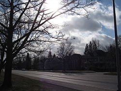

Location: Between RR tracks and Buffalo-Chapel St., Canandaigua, New York Coordinates: 42°53′35″N 77°17′8″W / 42.89306°N 77.28556°WCoordinates: 42°53′35″N 77°17′8″W / 42.89306°N 77.28556°W Built: 1800 Architectural style: Greek Revival, Late Victorian, Federal Governing body: Local NRHP Reference#: 73001239[1] Added to NRHP: July 20, 1973 North Main Street Historic District in Canandaigua, New York is a historic district that was listed on the NRHP in 1973.[1]
Significant buildings are the First Congregational Church, the 1812 built courthouse which was city hall by 1972, and a dozen Federal and Greek Revival architecture houses.[2]
The First Congregational Church in the district was covered in a HABS survey.[2]
References
- ^ a b "National Register Information System". National Register of Historic Places. National Park Service. 2009-03-13. http://nrhp.focus.nps.gov/natreg/docs/All_Data.html.
- ^ a b Brooke, Cornelia E. (April, 1972). "National Register of Historic Places Inventory/Nomination: North Main Street Historic District". New York State Office of Parks, Recreation and Historic Preservation. http://www.oprhp.state.ny.us/hpimaging/hp_view.asp?GroupView=11023. Retrieved 2010-09-20. and Accompanying 8 photos, from 1970
Categories:- Historic districts in New York
- Federal architecture in New York
- Greek Revival architecture in New York
- National Register of Historic Places in New York
- Historic districts in Ontario County, New York
- Ontario County, New York Registered Historic Place stubs


Wikimedia Foundation. 2010.