- National Register of Historic Places listings in Monroe County, Michigan
-
 Location of Monroe County in Michigan
This is a list of the National Register of Historic Places listings in Monroe County, Michigan.
This is intended to be a complete list of the properties and districts on the National Register of Historic Places in Monroe County, Michigan, United States. The locations of National Register properties and districts, for which the latitude and longitude coordinates are included below, may be seen on Google Maps[1] or Bing Maps.
There are 15 individual listings on the National Register in the county: nine properties, five historic districts, and one bridge. These listings include a lighthouse, statue, four houses, trading post, former factory, battlefield (Battle of Frenchtown), and five historic districts — one of which is an undeveloped archeological district. Although attempts have been made to include other properties, only the following 15 are officially listed on the National Register of Historic Places.[2] Nine of the listings are located within the county's largest city, Monroe. The first listed property was the Governor Robert McClelland House, which was added in 1971, and the most recent was the George Armstrong Custer Equestrian Monument, which was added in 1994. The oldest of all properties listed is the Navarre-Anderson Trading Post, which was first built in 1789. Settled in as early as 1780 and formally organized in 1817 as the second county in the Michigan Territory, Monroe County has a strong sense of historical preservationism.
-
- This National Park Service list is complete through NPS recent listings posted November 10, 2011.[3]
Current listings
[4] Landmark name [2] Image Date listed Location City or town Summary 1 George Armstrong Custer Equestrian Monument 
December 9, 1994 Junction of Elm Avenue and N. Monroe Street
41°55′05″N 83°23′48″W / 41.918056°N 83.396667°WMonroe A statue of George Armstrong Custer, who spent a portion of his childhood in Monroe, was unveiled by President Taft and Elizabeth Bacon Custer in 1910. Originally located near the courthouse and then later in a nearby park, the statue was moved to its current, prominent location in 1955. 2 Detroit River Light Station 
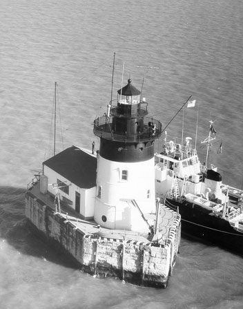
August 4, 1983 Lake Erie
42°00′03″N 83°08′28″W / 42.000833°N 83.141111°WBerlin Charter Township[5] Built in 1885, this lighthouse is situated near the mouth of the Detroit River about three miles (4.8 km) off the coast of Pointe Mouillee State Game Area in Lake Erie in the northern portion of the county. The lighthouse is still in operation today, albeit completely automated, and public access is prohibited. It is owned and operated by the United States Coast Guard. 3 Dundee Historic District 
August 20, 1990 Roughly bounded by Main, Monroe, and Toledo Streets; the River Raisin, and Riley, Tecumseh, and Ypsilanti Streets
41°57′22″N 83°39′38″W / 41.956111°N 83.660556°WDundee Also known as the "Triangle District" for the unique shape of the area's grid plan, surviving buildings in this area date back to 1866, with the area being settled in as early as 1825. The area, which is located about one mile (0.6 km) east of US-23 along the River Raisin, features prominent Italianate and Greek Revival architecture. The buildings today are occupied by various retail businesses and government offices. 4 East Elm-North Macomb Street Historic District 
May 6, 1982 Roughly bounded by the River Raisin and Lorain, Monroe, and Macomb Streets
41°55′08″N 83°23′30″W / 41.918889°N 83.391667°WMonroe Consisting of large houses dating back to the 1820s, the area is well known for its wide mixture of Greek Revival, Federal, Second Empire, and Victorian architecture. Some of Monroe's most significant residents, such as Robert McClelland, have resided in this area. Today, these grandiose dwellings are privately owned and are among the largest in Monroe. 5 Edward Loranger House 
May 31, 1984 7211 S. Stoney Creek Road
41°58′54″N 83°22′22″W / 41.981667°N 83.372778°WFrenchtown Charter Township Built in 1825 by famed local bricklayer, landowner, and architect Edward Loranger, it is one of the oldest intact structures in the county. Other buildings on the property, such as Loranger's sawmill, have been moved to The Henry Ford, while his house remains in its original location and has since been restored by its current owner. 6 Gov. Robert McClelland House 
September 3, 1971 47 E. Elm Avenue
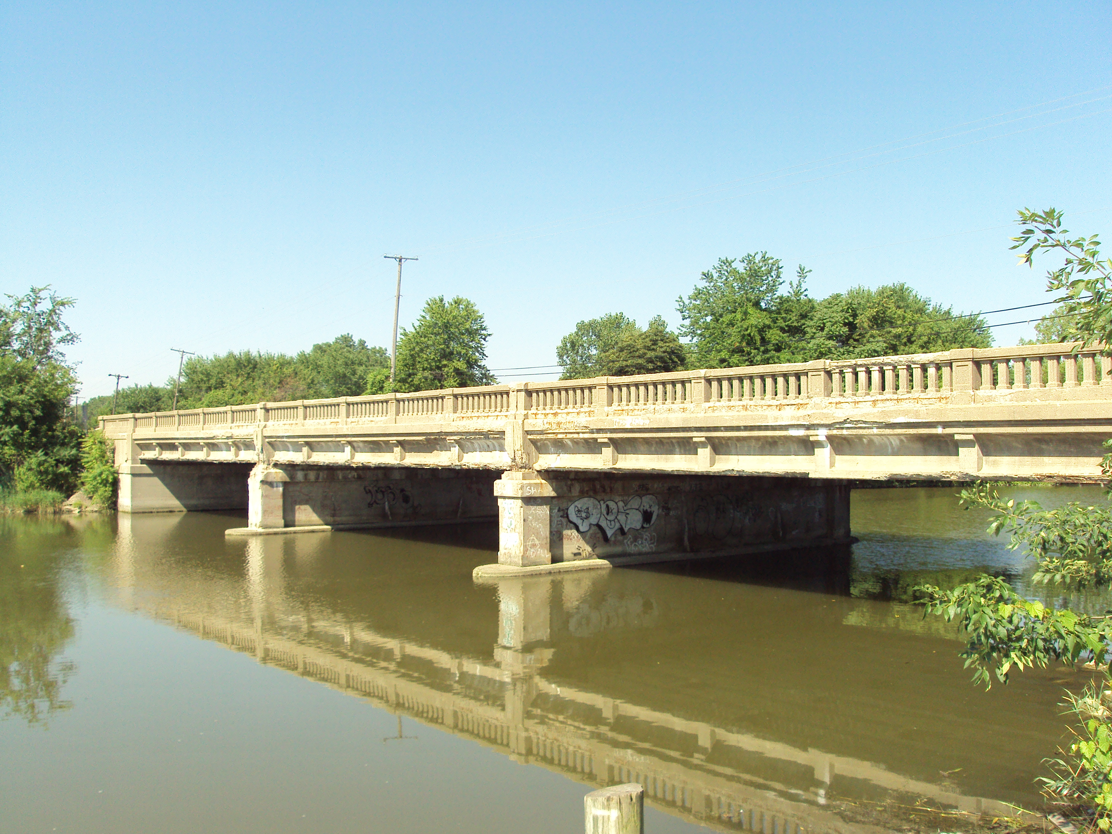
41°55′04″N 83°23′40″W / 41.917778°N 83.394444°WMonroe Robert McClelland lived for a brief period of time in this house, which was built in 1841. He was a very well known politician on the local, state, and national levels. His house is a prime example of Greek Revival architecture. Today, the house is privately owned and is also part of the East Elm-North Macomb Street Historic District 7 Jefferson Avenue-Huron River and Harbin Drive-Silver Creek Canal Bridges 
February 10, 2000 W. Jefferson Avenue over Huron River and Harbin Drive over Silver Creek Canal
42°02′32″N 83°12′52″W / 42.042222°N 83.214444°WBerlin Charter Township This listing covers two separate bridges: the Jefferson Avenue Bridge, which carries W. Jefferson Avenue over the Huron River and the smaller Harbin Drive Bridge spanning the Silver Creek Canal. Only the Jefferson Avenue Bridge is in Monroe County, as it connects Monroe County to Brownstown Charter Township in Wayne County. For that reason, it is also listed on the NRHP listings in Wayne County article. 8 Navarre-Anderson Trading Post 
July 31, 1972 West of Monroe at N. Custer (M-130) and Raisinville Roads
41°56′05″N 83°27′35″W / 41.934722°N 83.459722°WFrenchtown Charter Township The main building of this small complex was built in 1789 and is the oldest wooden residential building in the state. The cookhouse dates to 1810, while other buildings, such as the barn, are replicas. The buildings were moved from their original location in 1894, and the complex has been restored and sits near the corner of North Custer Road (formerly M-130) and Raisinville Road in the outskirts of Frenchtown Township along the River Raisin. 9 Rudolph Nims House 
October 18, 1972 206 W. Noble Street
41°55′21″N 83°23′52″W / 41.9225°N 83.397778°WMonroe Located two blocks west of M-125 in Monroe, this house was built between 1836–1846 in the style of Greek Revival architecture. Built by Jacques Godfroy, Rudolph Nims purchased the house in 1848, and the house remained in his family for over a century. The house has undergone extensive additions and remodeling, but the front facade remains original. Today, the house is privately owned. 10 North Maumee Bay Archeological District 
December 5, 1980 Address Restricted[6]
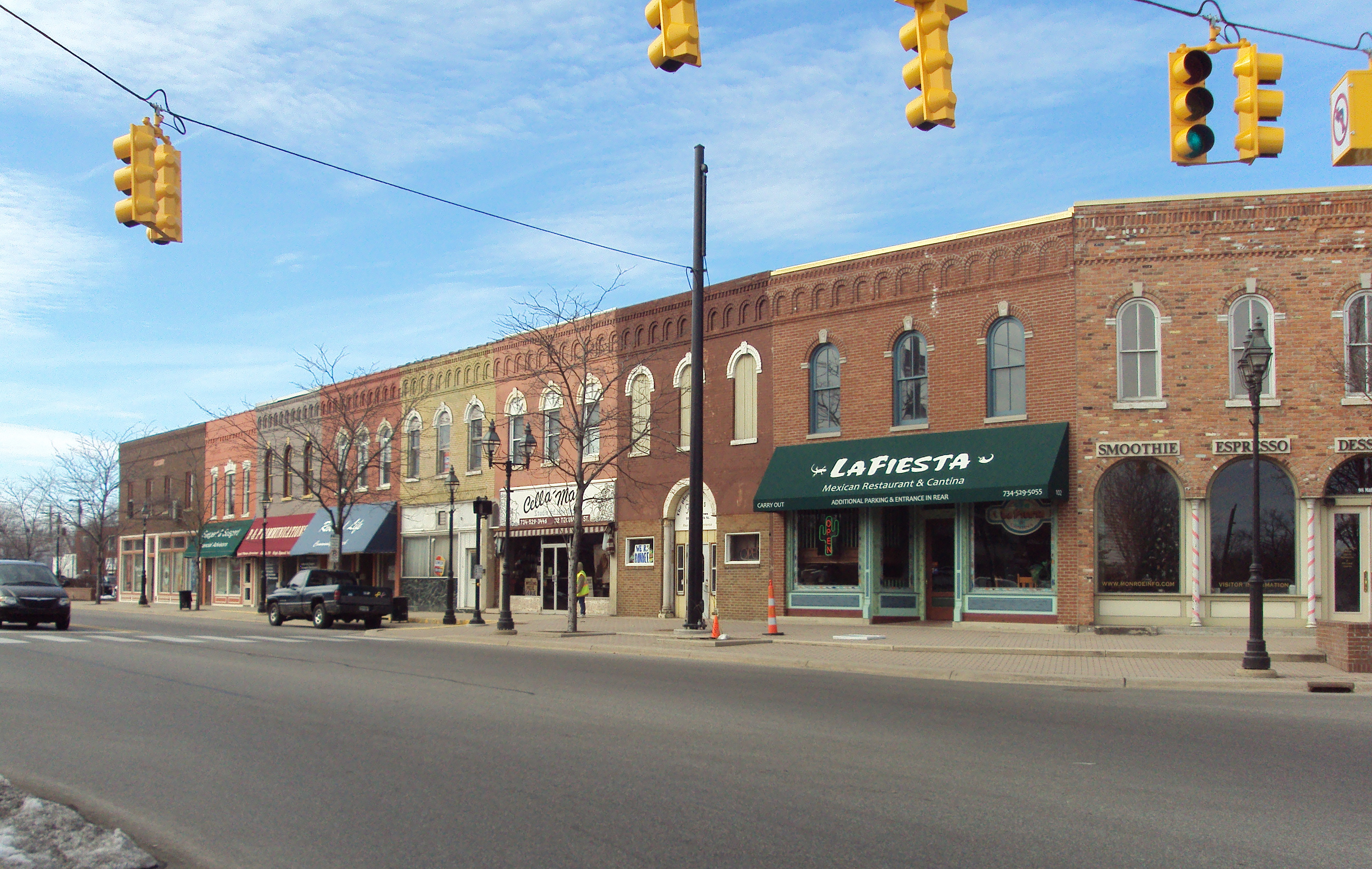
41°45′N 83°27′W / 41.75°N 83.45°WErie Township While the official address of the archeological site is restricted, the district incorporates the area of the North Maumee Bay at the mouth of the Ottawa River and Maumee River in Lake Erie. The sparsely populated area includes the Woodtick Peninsula, Garb Island, Indian Island, the Erie Fish and Hunt Club, and much of the grassy shoreline and interior wetlands. 11 Old Village Historic District 
May 6, 1982 M-50 and M-125
41°54′45″N 83°24′00″W / 41.9125°N 83.4°WMonroe This district centers around Front Street[7] and Monroe Street (M-125) and extends several blocks in the downtown area. Some of the buildings date back as early as 1830, and these buildings are now owned by various retail businesses and apartments. The outer areas of this district include the courthouse (1880) and the city's first post office (1913), which is now a museum. 12 River Raisin Battlefield Site (20MR227) 
December 10, 1982 Address Restricted[6]
41°54′49″N 83°22′43″W / 41.913611°N 83.378611°WMonroe The River Raisin National Battlefield Park is an authorized addition to the United States National Park System under the Omnibus Public Land Management Act of 2009. Located along the River Raisin, the park, which is still under construction, will commemorate the Battle of Frenchtown during the War of 1812. Though authorized, it is not yet included in the list of National Battlefield Parks. 13 Sawyer House 
November 23, 1977 320 E. Front Street
41°54′53″N 83°23′36″W / 41.914722°N 83.393333°WMonroe This Italianate house is on the oldest piece of European settled land in Monroe. The property was settled in as early as 1785 and had several incarnations and owners before the current house was built in 1873. The most famous resident of the property was Dr. Alfred Sawyer, who lived there from 1859–1870. In 1938, the house was given to the city. The house is currently open to the public for a wide variety of functions. 14 St. Mary's Church Complex Historic District 
May 6, 1982 Elm Avenue and Monroe Street (M-125)
41°55′08″N 83°23′48″W / 41.918889°N 83.396667°WMonroe This complex comprises four main buildings: St. Mary Church, the rectory, St. Mary Catholic Central High School, and the Brothers of Holy Cross Hall. The church itself dates back to 1788 and is one of the oldest Catholic parishes still in operation, while the current church building dates back to 1835 and is renowned for its Gothic Revival architecture. The church continues to be one of the most important religious institutions in Monroe. 15 Weis Manufacturing Company 
October 26, 1981 Union and West 7th Streets
41°54′56″N 83°24′39″W / 41.915556°N 83.410833°WMonroe This complex was constructed between 1905–1912 and was a major employer in Monroe for many decades. The company produced office equipment until it was converted into a manufacturing facility for La-Z-Boy in 1964. The facility was shut down in 1978. The city of Monroe purchased the abandoned facility in 1980 and has since remodeled it as a residential hall for senior citizens. See also
- List of National Historic Landmarks in Michigan
- National Register of Historic Places listings in Michigan
References
- ^ The latitude and longitude information provided in this table was derived originally from the National Register Information System, which has been found to be fairly accurate for about 99% of listings. For about 1% of NRIS original coordinates, experience has shown that one or both coordinates are typos or otherwise extremely far off; some corrections may have been made. A more subtle problem causes many locations to be off by up to 150 yards, depending on location in the country: most NRIS coordinates were derived from tracing out latitude and longitudes off of USGS topographical quadrant maps created under North American Datum of 1927, which differs from the current, highly accurate GPS system used by Google maps. Chicago is about right, but NRIS longitudes in Washington are higher by about 4.5 seconds, and are lower by about 2.0 seconds in Maine. Latitudes differ by about 1.0 second in Florida. Some locations in this table may have been corrected to current GPS standards.
- ^ a b "National Register Information System". National Register of Historic Places. National Park Service. . http://nrhp.focus.nps.gov/natreg/docs/All_Data.html.
- ^ "National Register of Historic Places: Weekly List Actions". National Park Service, United States Department of the Interior. Retrieved on November 10, 2011.
- ^ Numbers represent an ordering by significant words. Various colorings, defined here, differentiate National Historic Landmark sites and National Register of Historic Places Districts from other NRHP buildings, structures, sites or objects.
- ^ Certain documents list the Detroit River Light as being part of or being closest to the city of Rockwood. Rockwood is in Wayne County, but the lighthouse is within the northernmost water boundaries of Monroe County— in which it is within the boundaries of Berlin Charter Township. However, the Detroit River Light is owned and operated by the United States Coast Guard and is therefore not under the jurisdiction of any municipality.
- ^ a b While the National Register of History Places lists the address as restricted, the coordinates used are approximate locations of the landmark.
- ^ When the district was first designated on May 6, 1982, Front Street was known as M-50 and may appear named as such on certain lists and maps. However, in October 2006, M-50's eastern terminus was truncated 1.17 mile (0.66 km) from M-125 to US-24. The current road that runs through the Old Village Historic District is now under local control as Front Street. See, Bessert, Chris (1997–2009). Michigan Highways: Highways 50 to 59, accessed November 12, 2009.
National Register of Historic Places in Monroe County, Michigan Historic districts Dundee Historic District | East Elm-North Macomb Street Historic District | North Maumee Bay Archeological District | Old Village Historic District | St. Mary's Church Complex Historic District

Historic properties Detroit River Light Station | Edward Loranger House | George Armstrong Custer Equestrian Monument | Governor Robert McClelland House | Jefferson Avenue-Huron River Bridge | Navarre-Anderson Trading Post | River Raisin National Battlefield Park | Rudolph Nims House | Sawyer House | Weis Manufacturing Company
Contributing properties Old Mill Museum | St. Mary Catholic Central High School
See also: National Register of Historic Places listings in Monroe County, Michigan and List of National Historic Landmarks in Michigan National Register of Historic Places sites in metropolitan Detroit Topics Architecture • Celebrities • Culture • Detroit • Economy • History • Historic places • International Riverfront • Lake St. Clair • Media • Metro Detroit • Music • Parks and beaches • Sports • Theatre • Tourism
Historic places in central city Historic places by county in MSA Historic places by county in CSA U.S. National Register of Historic Places Topics Lists by states Alabama • Alaska • Arizona • Arkansas • California • Colorado • Connecticut • Delaware • Florida • Georgia • Hawaii • Idaho • Illinois • Indiana • Iowa • Kansas • Kentucky • Louisiana • Maine • Maryland • Massachusetts • Michigan • Minnesota • Mississippi • Missouri • Montana • Nebraska • Nevada • New Hampshire • New Jersey • New Mexico • New York • North Carolina • North Dakota • Ohio • Oklahoma • Oregon • Pennsylvania • Rhode Island • South Carolina • South Dakota • Tennessee • Texas • Utah • Vermont • Virginia • Washington • West Virginia • Wisconsin • WyomingLists by territories Lists by associated states Other  Category:National Register of Historic Places •
  Portal:National Register of Historic PlacesCategories:
- National Register of Historic Places in Michigan by county
- Monroe County, Michigan
- Buildings and structures in Monroe County, Michigan
-


Wikimedia Foundation. 2010.