- National Register of Historic Places listings in Ingham County, Michigan
-
 Location of Ingham County in Michigan
This is a list of the National Register of Historic Places listings in Ingham County, Michigan.
This is intended to be a complete list of the properties and districts on the National Register of Historic Places in Ingham County, Michigan, United States. The locations of National Register properties and districts for which the latitude and longitude coordinates are included below, may be seen in a Google map.[1]
There are 44 properties and districts listed on the National Register in the county, including 1 National Historic Landmark.
-
- This National Park Service list is complete through NPS recent listings posted November 10, 2011.[2]
Current listings
[3] Landmark name [4] Image Date listed Location City or town Summary 1 Arbaugh's Department Store Building July 20, 2007 401 S. Washington
42°43′46″N 84°33′07″W / 42.729444°N 84.551944°WLansing 2 Ash Street-Sycamore Creek Bridge January 14, 2000 M-36 over Sycamore Creek
42°34′45″N 84°26′51″W / 42.579167°N 84.4475°WMason 3 Brown-Price House March 22, 1984 1003 N. Washington Ave.
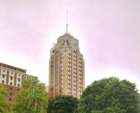
42°44′42″N 84°33′09″W / 42.745°N 84.5525°WLansing 4 Capital Bank Tower 
December 6, 2005 124 W. Allegan St.
42°43′58″N 84°33′11″W / 42.732778°N 84.553056°WLansing 5 Central Methodist Episcopal Church September 17, 1980 215 N. Capitol Ave.
42°44′06″N 84°33′16″W / 42.735°N 84.554444°WLansing 6 Central School 
April 10, 1986 325 W. Grand River Ave.
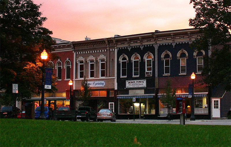
42°44′11″N 84°29′20″W / 42.736389°N 84.488889°WEast Lansing 7 Courthouse Square Historic District 
June 6, 1985 Bounded by Park, E. Columbia, Rodgers and South
42°34′43″N 84°26′31″W / 42.578611°N 84.441944°WMason 8 Dodge Mansion September 14, 1972 106 E. North St.
42°45′03″N 84°33′08″W / 42.750833°N 84.552222°WLansing 9 Emery Houses December 10, 1993 320-322 and 326-328 W. Ottawa
42°44′05″N 84°33′25″W / 42.734722°N 84.556944°WLansing 10 Eustace Hall 
September 3, 1971 Michigan State University campus
42°43′57″N 84°28′47″W / 42.7325°N 84.479722°WEast Lansing 11 Federal Building September 17, 1980 315 W. Allegan St.
42°43′55″N 84°33′23″W / 42.731944°N 84.556389°WLansing 12 First Baptist Church September 17, 1980 227 N. Capitol Ave.
42°44′08″N 84°33′16″W / 42.735556°N 84.554444°WLansing 13 Franklin Avenue Presbyterian Church May 27, 1988 108 W. Grand River Ave.
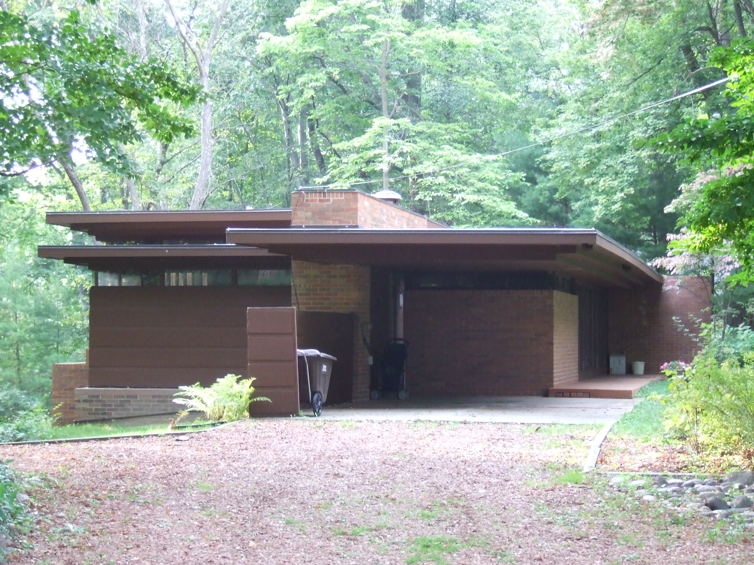
42°44′53″N 84°33′08″W / 42.748056°N 84.552222°WLansing 14 Goetsch-Winckler House 
December 13, 1995 2410 Hulett Rd., Meridian Township
42°42′29″N 84°26′21″W / 42.708056°N 84.439167°WOkemos 15 Grand Trunk Western Rail Station/Lansing Depot July 3, 1980 1203 S. Washington Ave.
42°43′10″N 84°33′05″W / 42.719444°N 84.551389°WLansing 16 Ingham County Courthouse 
December 13, 1971 Jefferson and Ash Sts.
42°34′44″N 84°26′34″W / 42.578889°N 84.442778°WMason 17 J.W. Knapp Company Building May 21, 1983 300 S. Washington Ave.
42°43′52″N 84°33′10″W / 42.731111°N 84.552778°WLansing 18 Lansing Artillery Michigan National Guard Armory December 13, 2010 330 Marshall St.
42°44′15″N 84°31′34″W / 42.7375°N 84.526111°WLansing 19 Lansing Downtown Historic District July 22, 2009 N. and S. Washington, Grand, N. and S. Capitol, Michigan Ave., Allegan, Washtenaw, Kalamazoo, Lenawee, and Townsend
42°43′53″N 84°33′11″W / 42.731331°N 84.553039°WLansing 20 Lansing Woman's Club Building September 17, 1980 118 W. Ottawa St.
42°44′05″N 84°33′11″W / 42.734722°N 84.553056°WLansing 21 Maple Grove Cemetery June 6, 1985 W. Columbia St.
42°35′03″N 84°26′44″W / 42.584167°N 84.445556°WMason 22 Masonic Temple Building 
March 29, 1999 314 M.A.C. Ave.
42°44′10″N 84°28′49″W / 42.736111°N 84.480278°WEast Lansing 23 Masonic Temple Building September 17, 1980 217 S. Capitol Ave.
42°43′55″N 84°33′12″W / 42.731944°N 84.553333°WLansing 24 Merrylees-Post House June 6, 1985 519 W. Ash St.
42°34′44″N 84°27′04″W / 42.578889°N 84.451111°WMason 25 Michigan Central Railroad Mason Depot June 6, 1985 111 N. Mason St.
42°34′58″N 84°26′55″W / 42.582778°N 84.448611°WMason 26 Michigan Millers Mutual Fire Insurance Company Building September 17, 1980 120-122 W. Ottawa St.
42°44′05″N 84°33′12″W / 42.734722°N 84.553333°WLansing 27 Michigan State Capitol 
January 25, 1971 Capitol and Michigan Aves.
42°44′01″N 84°33′20″W / 42.733611°N 84.555556°WLansing 28 Darius B. Moon House November 30, 1982 216 Huron St.
42°43′54″N 84°34′19″W / 42.731667°N 84.571944°WLansing 29 J.H. Moores Memorial Natatorium January 14, 1985 2700 Moores River Dr.
42°43′01″N 84°33′23″W / 42.716944°N 84.556389°WLansing 30 Mutual Building September 17, 1980 208 N. Capitol Ave.
42°44′07″N 84°33′13″W / 42.735278°N 84.553611°WLansing 31 Philip Nice House June 6, 1985 321 Center St.
42°34′59″N 84°26′52″W / 42.583056°N 84.447778°WMason 32 North Lansing Historic Commercial District April 30, 1976 E. Grand River Ave. and Turner St.
42°44′52″N 84°33′00″W / 42.747778°N 84.55°WLansing 33 Ottawa Street Power Station 
November 26, 2008 217 E. Ottawa St.
42°44′05″N 84°33′02″W / 42.734639°N 84.550444°WLansing 34 Prudden Wheel Company Building May 30, 2007 707 Prudden St.
42°44′27″N 84°32′33″W / 42.740833°N 84.5425°WLansing 35 John Raynor House June 6, 1985 725 E. Ash St.
42°34′42″N 84°25′53″W / 42.578333°N 84.431389°WMason 36 Smith-Turner House July 11, 1980 326 W. Grand River Ave.
42°44′51″N 84°33′24″W / 42.7475°N 84.556667°WLansing 37 Somerville Barn March 17, 2005 1050 N. College Rd.
42°36′45″N 84°28′59″W / 42.6125°N 84.483056°WAlaiedon Township 38 St. Katherine's Chapel 
July 8, 1970 4650 Meridian Rd., east of East Lansing
42°43′07″N 84°21′43″W / 42.718611°N 84.361944°WEast Lansing 39 St. Mary Cathedral November 2, 1990 229 Seymour St.
42°44′08″N 84°33′22″W / 42.735556°N 84.556111°WLansing 40 State Office Building May 17, 1984 316 S. Walnut St.
42°43′50″N 84°33′28″W / 42.730556°N 84.557778°WLansing 41 Stockbridge Town Hall March 10, 1980 101 S. Clinton St.
42°27′02″N 84°10′46″W / 42.450556°N 84.179444°WStockbridge 42 Strand Theatre and Arcade September 17, 1980 211-219 S. Washington Ave.
42°43′55″N 84°33′05″W / 42.731944°N 84.551389°WLansing 43 Union Depot 
July 21, 1995 637 E. Michigan Ave.
42°44′04″N 84°32′36″W / 42.734444°N 84.543333°WLansing 44 Westside Neighborhood Historic District June 6, 1985 Roughly bounded by W. Maple, W. Ash, Lansing and McRoberts Sts.
42°34′47″N 84°26′56″W / 42.579722°N 84.448889°WMason See also
- List of National Historic Landmarks in Michigan
- National Register of Historic Places listings in Michigan
References
- ^ The latitude and longitude information provided in this table was derived originally from the National Register Information System, which has been found to be fairly accurate for about 99% of listings. For about 1% of NRIS original coordinates, experience has shown that one or both coordinates are typos or otherwise extremely far off; some corrections may have been made. A more subtle problem causes many locations to be off by up to 150 yards, depending on location in the country: most NRIS coordinates were derived from tracing out latitude and longitudes off of USGS topographical quadrant maps created under North American Datum of 1927, which differs from the current, highly accurate GPS system used by Google maps. Chicago is about right, but NRIS longitudes in Washington are higher by about 4.5 seconds, and are lower by about 2.0 seconds in Maine. Latitudes differ by about 1.0 second in Florida. Some locations in this table may have been corrected to current GPS standards.
- ^ "National Register of Historic Places: Weekly List Actions". National Park Service, United States Department of the Interior. Retrieved on November 10, 2011.
- ^ Numbers represent an ordering by significant words. Various colorings, defined here, differentiate National Historic Landmark sites and National Register of Historic Places Districts from other NRHP buildings, structures, sites or objects.
- ^ "National Register Information System". National Register of Historic Places. National Park Service. . http://nrhp.focus.nps.gov/natreg/docs/All_Data.html.
U.S. National Register of Historic Places Topics Lists by states Alabama • Alaska • Arizona • Arkansas • California • Colorado • Connecticut • Delaware • Florida • Georgia • Hawaii • Idaho • Illinois • Indiana • Iowa • Kansas • Kentucky • Louisiana • Maine • Maryland • Massachusetts • Michigan • Minnesota • Mississippi • Missouri • Montana • Nebraska • Nevada • New Hampshire • New Jersey • New Mexico • New York • North Carolina • North Dakota • Ohio • Oklahoma • Oregon • Pennsylvania • Rhode Island • South Carolina • South Dakota • Tennessee • Texas • Utah • Vermont • Virginia • Washington • West Virginia • Wisconsin • WyomingLists by territories Lists by associated states Other Categories:- National Register of Historic Places in Michigan by county
- Ingham County, Michigan
- Buildings and structures in Ingham County, Michigan
-


Wikimedia Foundation. 2010.