- National Register of Historic Places listings in Shiawassee County, Michigan
-
The following is a list of Registered Historic Places in Shiawassee County, Michigan.
-
- This National Park Service list is complete through NPS recent listings posted November 10, 2011.[1]
[2] Landmark name [3] Image Date listed Location City or town Summary 1 Nathan Ayres House November 4, 1980 604 N. Water St.
43°00′11″N 84°10′23″W / 43.003056°N 84.173056°WOwosso 2 Byron Historic Commercial District September 13, 1984 Roughly Saginaw St. from Maple to Water Sts.
42°49′20″N 83°56′39″W / 42.822222°N 83.944167°WByron 3 Charles H. Calkins House March 29, 1978 127 E. 1st St.
42°49′27″N 84°13′05″W / 42.824167°N 84.218056°WPerry 4 Leigh Christian House November 4, 1980 622 N. Ball St.
43°00′13″N 84°10′19″W / 43.003611°N 84.171944°WOwosso 5 Christian-Ellis House November 4, 1980 600 N. Water St.
43°00′10″N 84°10′23″W / 43.002778°N 84.173056°WOwosso 6 Hezekiah W. and Sarah E. Fishell Cobb House April 11, 1997 115 W. 2nd St.
42°49′29″N 84°13′12″W / 42.824722°N 84.22°WPerry 7 Elias Comstock Cabin November 4, 1980 Curwood Castle Dr., and John St.
42°59′57″N 84°10′32″W / 42.999167°N 84.175556°WOwosso 8 Curwood Castle 
September 3, 1971 224 John St.
42°59′34″N 84°10′31″W / 42.992778°N 84.175278°WOwosso 9 Duff Building January 31, 1985 118 W. Exchange St
42°59′55″N 84°10′18″W / 42.998611°N 84.171667°WOwosso 10 Durand High School March 17, 2009 100 West Sycamore Street
42°54′55″N 83°59′11″W / 42.915278°N 83.986389°WDurand 11 Frederick Frieseke Birthplace and Boyhood Home November 4, 1980 654 N. Water St.
43°00′15″N 84°10′23″W / 43.004167°N 84.173056°WOwosso 12 Julius Frieseke House April 5, 1990 529 Corunna Ave.
42°59′30″N 84°09′51″W / 42.991667°N 84.164167°WOwosso 13 Amos Gould House November 4, 1980 115 W. King St.
43°00′16″N 84°10′18″W / 43.004444°N 84.171667°WOwosso 14 Daniel Gould House November 4, 1980 509 E. Main St.
42°59′51″N 84°09′51″W / 42.9975°N 84.164167°WOwosso 15 Ebenezer Gould House November 4, 1980 603 W. Main St.
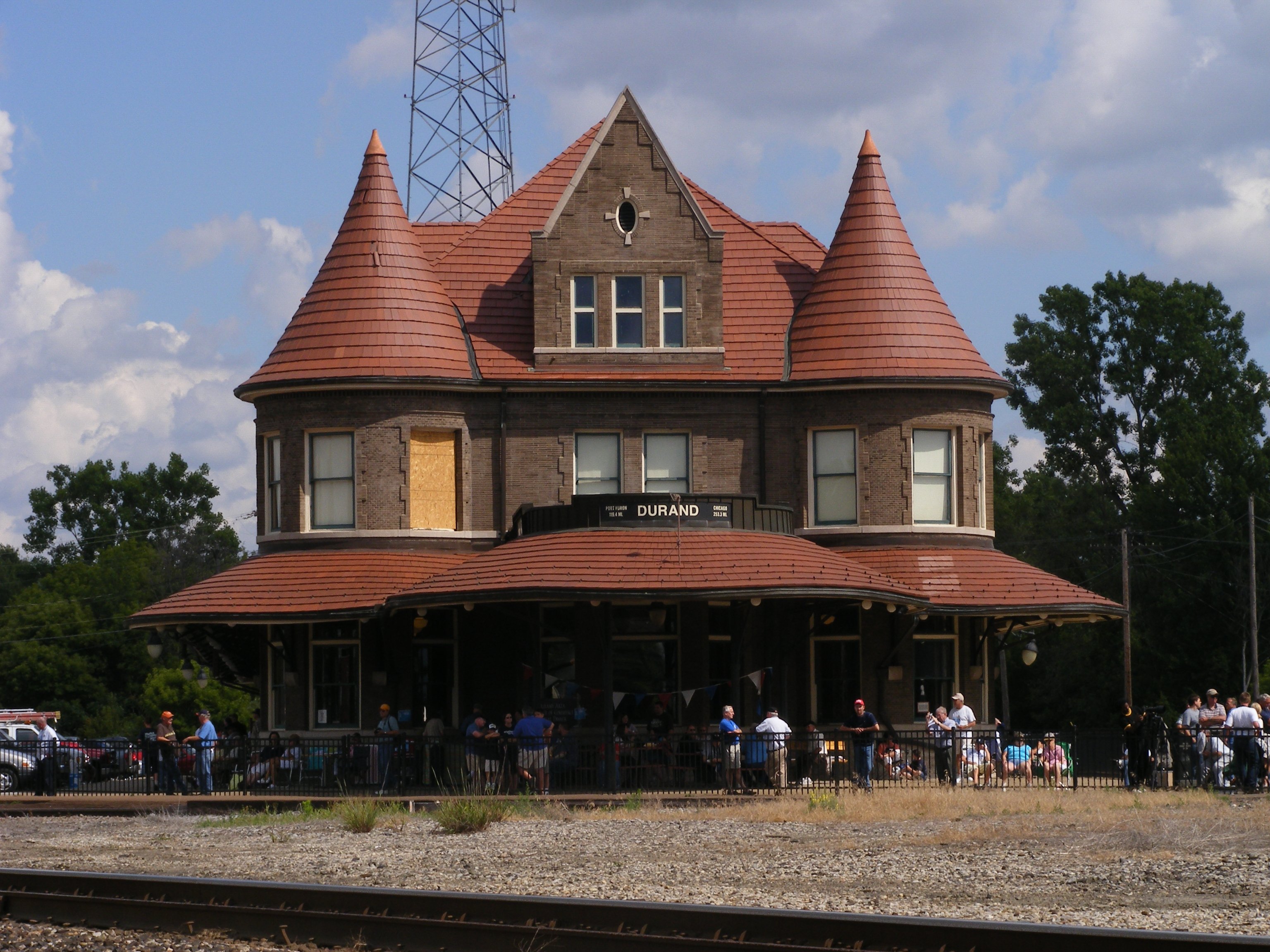
42°59′50″N 84°10′43″W / 42.997222°N 84.178611°WOwosso 16 Grand Trunk Railway Station 
May 6, 1971 200 Railroad St.
42°54′33″N 83°58′57″W / 42.909167°N 83.9825°WDurand 17 Grow Block January 31, 1985 120-122 W. Exchange St.
42°59′56″N 84°10′18″W / 42.998889°N 84.171667°WOwosso 18 William Horton Farmhouse April 10, 1986 1647 W. Miller Rd.
42°51′49″N 84°11′52″W / 42.863611°N 84.197778°WMorrice 19 House at 314 W. King St. November 4, 1980 314 W. King St.
43°00′18″N 84°10′26″W / 43.005°N 84.173889°WOwosso 20 John N. Ingersoll House May 9, 1980 570 W. Corunna Ave.
42°58′57″N 84°07′35″W / 42.9825°N 84.126389°WCorunna 21 Eugene Jacobs House November 4, 1980 220 W. King St.
43°00′18″N 84°10′23″W / 43.005°N 84.173056°WOwosso 22 Martin Road Bridge July 12, 1991 Martin Rd. across the Shiawassee River, Caledonia Township
42°58′08″N 84°03′21″W / 42.968889°N 84.055833°WCorunna 23 Mason Street Historic Residential District November 4, 1980 Roughly bounded by Laverock Alley, Dewey, Hickory and Exchange Sts.
42°59′57″N 84°09′54″W / 42.999167°N 84.165°WOwosso 24 Colin McCormick House November 4, 1980 222 E. Exchange St.
42°59′53″N 84°10′06″W / 42.998056°N 84.168333°WOwosso 25 Michigan Avenue-Genessee Street Historic Residential District November 4, 1980 Roughly bounded by Michigan Ave.; Shiawassee, Cass and Clinton Sts.
42°59′43″N 84°10′32″W / 42.995278°N 84.175556°WOwosso 26 Selden Miner House November 4, 1980 418 W. King St.
43°00′18″N 84°10′32″W / 43.005°N 84.175556°WOwosso 27 Old Miller Hospital November 4, 1980 121 Michigan Ave.
42°59′48″N 84°10′29″W / 42.996667°N 84.174722°WOwosso 28 Oliver Street Historic District November 4, 1980 Oliver St. between 3rd and Oak Sts., Williams and Goodhue Sts.
43°00′06″N 84°10′24″W / 43.001667°N 84.173333°WOwosso 29 Sylvester Opdyke House November 4, 1980 655 N. Pine St.
43°00′16″N 84°10′33″W / 43.004444°N 84.175833°WOwosso 30 Albert Palmer House November 4, 1980 528 530 River St.
42°59′58″N 84°10′43″W / 42.999444°N 84.178611°WOwosso 31 George Pardee House November 4, 1980 603 N. Ball St.
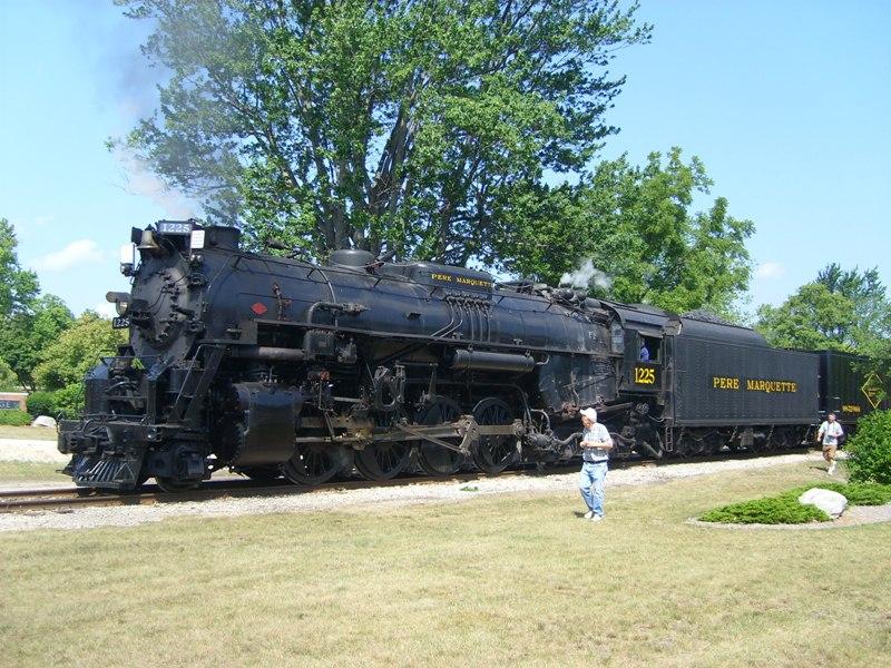
43°00′10″N 84°10′20″W / 43.002778°N 84.172222°WOwosso 32 Pere Marquette Railway Steam Locomotive No. 1225 
July 31, 1994 600 S. Oakwood St.
42°59′35″N 84°09′53″W / 42.993056°N 84.164722°WOwosso 33 George Perrigo House November 4, 1980 213 N. Cedar St.
42°59′56″N 84°10′55″W / 42.998889°N 84.181944°WOwosso 34 Shiawassee County Courthouse November 12, 1982 Shiawassee St.
42°58′53″N 84°07′02″W / 42.981389°N 84.117222°WCorunna see Claire Allen for more info 35 Edwin Todd House November 4, 1980 520 N. Adam St.
43°00′10″N 84°10′28″W / 43.002778°N 84.174444°WOwosso 36 West Town Historic Commercial and Industrial District November 4, 1980 Main St.
42°59′55″N 84°11′02″W / 42.998611°N 84.183889°WOwosso 37 Alfred Williams House November 4, 1980 611 N. Ball St.
43°00′12″N 84°10′20″W / 43.003333°N 84.172222°WOwosso 38 Benjamin Williams House November 4, 1980 628 N. Ball St.
43°00′14″N 84°10′19″W / 43.003889°N 84.171944°WOwosso 39 Williams-Cole House December 4, 1986 6810 Newburg Rd.
42°54′35″N 84°01′49″W / 42.909722°N 84.030278°WDurand 40 Lee Woodard and Sons Building November 4, 1980 306 S. Elm St.
42°59′42″N 84°10′42″W / 42.995°N 84.178333°WOwosso 41 Lyman Woodard Company Workers' Housing November 4, 1980 601 Clinton St.
42°59′47″N 84°10′43″W / 42.996389°N 84.178611°WOwosso 42 Lyman Woodard Furniture and Casket Company Building November 4, 1980 216-222 Elm St.
42°59′44″N 84°10′43″W / 42.995556°N 84.178611°WOwosso See also
References
- ^ "National Register of Historic Places: Weekly List Actions". National Park Service, United States Department of the Interior. Retrieved on November 10, 2011.
- ^ Numbers represent an ordering by significant words. Various colorings, defined here, differentiate National Historic Landmark sites and National Register of Historic Places Districts from other NRHP buildings, structures, sites or objects.
- ^ "National Register Information System". National Register of Historic Places. National Park Service. . http://nrhp.focus.nps.gov/natreg/docs/All_Data.html.
U.S. National Register of Historic Places Topics Lists by states Alabama • Alaska • Arizona • Arkansas • California • Colorado • Connecticut • Delaware • Florida • Georgia • Hawaii • Idaho • Illinois • Indiana • Iowa • Kansas • Kentucky • Louisiana • Maine • Maryland • Massachusetts • Michigan • Minnesota • Mississippi • Missouri • Montana • Nebraska • Nevada • New Hampshire • New Jersey • New Mexico • New York • North Carolina • North Dakota • Ohio • Oklahoma • Oregon • Pennsylvania • Rhode Island • South Carolina • South Dakota • Tennessee • Texas • Utah • Vermont • Virginia • Washington • West Virginia • Wisconsin • WyomingLists by territories Lists by associated states Other Categories:- National Register of Historic Places in Michigan by county
- Shiawassee County, Michigan
- Buildings and structures in Shiawassee County, Michigan
-


Wikimedia Foundation. 2010.