- National Register of Historic Places listings in Sheridan County, Wyoming
-
 Location of Sheridan County in Wyoming
This is a list of the National Register of Historic Places listings in Sheridan County, Wyoming. It is intended to be a complete list of the properties and districts on the National Register of Historic Places in Sheridan County, Wyoming, United States. The locations of National Register properties and districts for which the latitude and longitude coordinates are included below, may be seen in a Google map.[1]
There are 23 properties and districts listed on the National Register in the county, 1 of which is a National Historic Landmark.
-
- This National Park Service list is complete through NPS recent listings posted November 10, 2011.[2]
Contents: Counties in Wyoming Albany - Big Horn - Campbell - Carbon - Converse - Crook - Fremont - Goshen - Hot Springs - Johnson - Laramie - Lincoln - Natrona - Niobrara - Park - Platte - Sheridan - Sublette - Sweetwater - Teton - Uinta - Washakie - Weston Listings county-wide
[3] Landmark name Image Date listed Location City or town Summary 1 Big Goose Creek Buffalo Jump 
February 12, 1974 Address Restricted[4] Sheridan 2 Big Red Ranch Complex October 11, 1984 Off U.S. Routes 14/16
44°33′52″N 106°31′37″W / 44.564444°N 106.526944°WUcross 3 CKW Bridge over Powder River 
February 22, 1985 U.S. Routes 14/16
44°41′51″N 106°05′58″W / 44.6975°N 106.099444°WArvada 4 Clearmont Jail May 14, 1984 Water St.
44°38′20″N 106°22′46″W / 44.638889°N 106.379444°WClearmont 5 Connor Battlefield August 12, 1971 City park on the Tongue River
44°54′19″N 107°09′43″W / 44.905278°N 107.161944°WRanchester 6 Dayton Community Hall November 25, 2005 410 Bridge St.
44°52′34″N 107°15′16″W / 44.876111°N 107.254444°WDayton 7 EAU Arvada Bridge 
February 22, 1985 County Road CN3-38
44°39′35″N 106°07′48″W / 44.659722°N 106.13°WArvada 8 EBF Bridge over Powder River 
February 22, 1985 County Road CN3-269
44°52′49″N 106°03′41″W / 44.880278°N 106.061389°WLeiter 9 ECR Kooi Bridge February 22, 1985 County Road CN3-93
44°54′33″N 107°05′13″W / 44.909167°N 107.086944°WMonarch 10 ECS Bridge over Big Goose Creek 
February 22, 1985 County Road CN3-93
44°44′35″N 107°07′45″W / 44.743056°N 107.129167°WSheridan 11 Fort MacKenzie June 18, 1981 North of Sheridan on Wyoming Highway 337
44°49′39″N 106°58′55″W / 44.8275°N 106.981944°WSheridan 12 Johnson Street Historic District April 9, 1984 Johnson, 1st, and 2nd Sts.
44°40′49″N 106°59′28″W / 44.680278°N 106.991111°WBig Horn 13 Mount View December 8, 1997 610 S. Jefferson St.
44°47′30″N 106°57′40″W / 44.791667°N 106.961111°WSheridan 14 Odd Fellows Hall December 9, 1980 Jackson St.
44°40′46″N 106°59′27″W / 44.679444°N 106.990833°WBig Horn 15 Quarter Circle A Ranch August 10, 1976 2 mi (3.2 km) southwest of Big Horn
44°38′26″N 107°00′53″W / 44.640556°N 107.014722°WBig Horn 16 Sheridan County Courthouse November 15, 1982 Burkett and Main St.
44°47′42″N 106°57′21″W / 44.795°N 106.955833°WSheridan 17 Sheridan County Fairgrounds Historic District August 10, 2011 1753 Victoria St.
44°48′16″N 106°58′53″W / 44.804444°N 106.981389°WSheridan 18 Sheridan Flouring Mills, Inc. 
December 8, 1997 2161 Coffeen Ave.
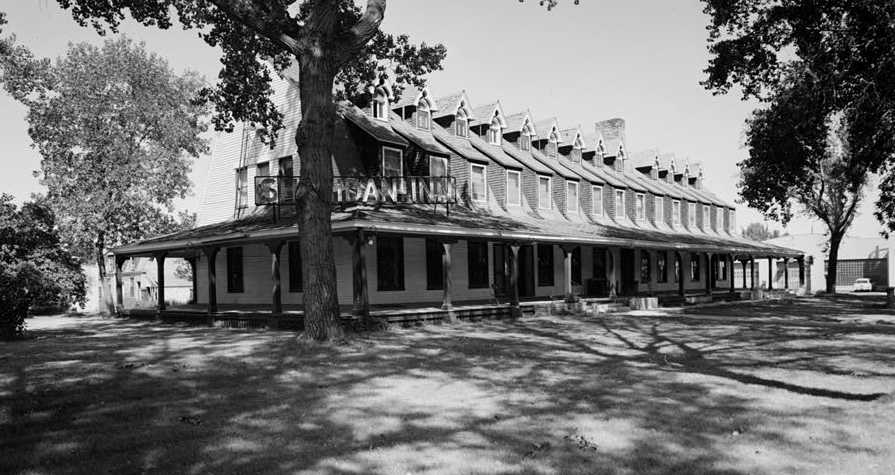
44°46′28″N 106°56′28″W / 44.774444°N 106.941111°WSheridan 19 Sheridan Inn 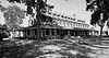
October 15, 1966 Broadway and 5th St.
44°48′21″N 106°57′09″W / 44.805833°N 106.9525°WSheridan 20 Sheridan Main Street Historic District November 9, 1982 Main St. from Burkitt to Mandel Sts.
44°47′55″N 106°57′19″W / 44.798611°N 106.955278°WSheridan 21 Sheridan Railroad Historic District November 12, 2004 201-841 Broadway, 508-955 N. Gould
44°48′19″N 106°57′11″W / 44.805278°N 106.953056°WSheridan 22 Trail End February 26, 1970 400 Claredon Ave. Sheridan 23 Susan Wissler House March 8, 1984 406 Main St.
44°52′27″N 107°15′43″W / 44.874167°N 107.261944°WDayton See also
- List of National Historic Landmarks in Wyoming
- National Register of Historic Places listings in Wyoming
References
- ^ The latitude and longitude information provided in this table was derived originally from the National Register Information System, which has been found to be fairly accurate for about 99% of listings. For about 1% of NRIS original coordinates, experience has shown that one or both coordinates are typos or otherwise extremely far off; some corrections may have been made. A more subtle problem causes many locations to be off by up to 150 yards, depending on location in the country: most NRIS coordinates were derived from tracing out latitude and longitudes off of USGS topographical quadrant maps created under the North American Datum of 1927, which differs from the current, highly accurate WGS84 GPS system used by Google maps. Chicago is about right, but NRIS longitudes in Washington are higher by about 4.5 seconds, and are lower by about 2.0 seconds in Maine. Latitudes differ by about 1.0 second in Florida. Some locations in this table may have been corrected to current GPS standards.
- ^ "National Register of Historic Places: Weekly List Actions". National Park Service, United States Department of the Interior. Retrieved on November 10, 2011.
- ^ Numbers represent an ordering by significant words. Various colorings, defined here, differentiate National Historic Landmark sites and National Register of Historic Places Districts from other NRHP buildings, structures, sites or objects.
- ^ Some listings on the NRHP are highly sensitive sites and may be subject to looting or vandalism. The NRHP lists this site as "Address Restricted."
U.S. National Register of Historic Places Topics Lists by states Alabama • Alaska • Arizona • Arkansas • California • Colorado • Connecticut • Delaware • Florida • Georgia • Hawaii • Idaho • Illinois • Indiana • Iowa • Kansas • Kentucky • Louisiana • Maine • Maryland • Massachusetts • Michigan • Minnesota • Mississippi • Missouri • Montana • Nebraska • Nevada • New Hampshire • New Jersey • New Mexico • New York • North Carolina • North Dakota • Ohio • Oklahoma • Oregon • Pennsylvania • Rhode Island • South Carolina • South Dakota • Tennessee • Texas • Utah • Vermont • Virginia • Washington • West Virginia • Wisconsin • WyomingLists by territories Lists by associated states Other Municipalities and communities of Sheridan County, Wyoming City 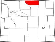
Towns CDPs Unincorporated
communitiesCategories:- National Register of Historic Places in Wyoming by county
- Sheridan County, Wyoming
-


Wikimedia Foundation. 2010.