- National Register of Historic Places listings in Sweetwater County, Wyoming
-
 Location of Sweetwater County in Wyoming
This is a list of the National Register of Historic Places listings in Sweetwater County, Wyoming.
This is intended to be a complete list of the properties and districts on the National Register of Historic Places in Sweetwater County, Wyoming, United States. The locations of National Register properties and districts for which the latitude and longitude coordinates are included below, may be seen in a Google map.[1]
There are 30 properties and districts listed on the National Register in the county, 1 of which is a National Historic Landmark.
-
- This National Park Service list is complete through NPS recent listings posted November 10, 2011.[2]
Contents: Counties in Wyoming Albany - Big Horn - Campbell - Carbon - Converse - Crook - Fremont - Goshen - Hot Springs - Johnson - Laramie - Lincoln - Natrona - Niobrara - Park - Platte - Sheridan - Sublette - Sweetwater - Teton - Uinta - Washakie - Weston Current listings
[3] Landmark name Image Date listed Location City or town Summary 1 Araphoe and Lost Creek Site (48SW4882) 
March 12, 1986 Address restricted[4] Hadsell Cabin 2 City Hall 
May 15, 1980 4th and B Sts.
41°35′06″N 109°13′14″W / 41.585°N 109.220556°WRock Springs 3 Dean Decker Site (48FR916; 48SW541) March 12, 1986 Address restricted[4] Honeycomb Buttes 4 Downtown Rock Springs Historic District 
January 19, 1994 Roughly bounded by K, 4th, C, 2nd, A, and 5th Sts.
41°35′13″N 109°13′11″W / 41.586944°N 109.219722°WRock Springs 5 Dug Springs Station Site September 22, 1977 Address restricted[4] Rock Springs 6 Eldon-Wall Terrace Site (48SW4320) December 13, 1985 Address restricted[4] Westvaco 7 ETD Bridge over Green River 
February 22, 1985 County Road CN4-8SS
41°58′49″N 110°02′43″W / 41.980278°N 110.045278°WFontenelle 8 ETR Big Island Bridge 
February 22, 1985 County Road CN4-4
41°45′52″N 109°44′05″W / 41.764444°N 109.734722°WGreen River 9 Expedition Island 
November 24, 1968 South of the Union Pacific railroad bridge, near the eastern bank of the Green River
41°31′28″N 109°28′19″W / 41.524444°N 109.471944°WGreen River 10 The Finley Site November 17, 2010 4 miles southeast of Eden Eden vicinity 11 First National Bank Building March 13, 1980 502 S. Main St.
41°35′30″N 109°13′12″W / 41.591667°N 109.22°WRock Springs 12 Granger Station 
February 26, 1970 In Granger
41°35′25″N 109°58′08″W / 41.590278°N 109.968889°WGranger 13 Gras House March 13, 1986 616 W. Elias
41°35′24″N 109°13′10″W / 41.59°N 109.219444°WRock Springs 14 Green River Downtown Historic District January 8, 2009 72-142 Flaming Gorge Way, 58-94 N. 1st St., 125-200 E. Railroad Ave., 62-94 N. 1st E. St., and the pedestrian overpass
41°31′42″N 109°27′59″W / 41.52847°N 109.46634°WGreen River 15 Laclede Station Ruin December 6, 1978 Off BLM Road 4409 along Bitter Creek, southeast of the community of Bitter Creek
41°25′21″N 108°24′45″W / 41.4225°N 108.4125°W[5]Rock Springs 16 Natural Corrals Archeological Site (48SW336) August 17, 1987 Address restricted[4] Superior 17 Our Lady Sorrows Catholic Church November 6, 1997 A at Broadway
41°34′58″N 109°13′18″W / 41.582778°N 109.221667°WRock Springs 18 Parting of the Ways January 11, 1976 15 miles northeast of Farson
42°15′27″N 109°13′42″W / 42.2575°N 109.228333°WFarson 19 Point of Rocks Stage Station 
April 3, 1970 Off Interstate 80
41°40′30″N 108°47′30″W / 41.675°N 108.791667°WRock Springs 20 Red Rock November 21, 1978 Southwest of Rawlins
41°25′46″N 108°00′05″W / 41.429444°N 108.001389°WRawlins 21 Reliance School and Gymnasium May 13, 1988 1321 Main St.
41°39′38″N 109°11′31″W / 41.660556°N 109.191944°WReliance 22 Reliance Tipple May 23, 1991 East of U.S. Route 187
41°40′05″N 109°11′46″W / 41.668056°N 109.196111°WReliance 23 Rock Springs Elks' Lodge No. 624 December 10, 1993 307 C St.
41°35′03″N 109°13′07″W / 41.584167°N 109.218611°WRock Springs 24 Slovenski Dom December 30, 1997 513 Bridger Ave.
41°35′29″N 109°13′15″W / 41.591389°N 109.220833°WRock Springs 25 South Superior Union Hall 
November 25, 1983 Main and Bridge Sts.
41°45′45″N 108°58′03″W / 41.7625°N 108.9675°WSuperior 26 Elinore Pruitt Stewart Homestead April 25, 1985 Off Wyoming Highway 414
41°00′44″N 109°59′35″W / 41.012222°N 109.993056°WMcKinnon 27 Sweetwater Brewery 
November 1, 1982 48 W. Railroad Ave.
41°31′44″N 109°28′05″W / 41.528889°N 109.468056°WGreen River 28 Taliaferro House July 23, 1998 106 Cedar St.
41°34′53″N 109°13′07″W / 41.581389°N 109.218611°WRock Springs 29 US Post Office-Green River December 11, 1997 3 W. Flaming Gorge Way
41°30′42″N 109°27′31″W / 41.511667°N 109.458611°WGreen River 30 Wardell Court Historic Residential District January 30, 1997 Wardell Court at its junction with D St.
41°34′56″N 109°12′50″W / 41.582222°N 109.213889°WRock Springs See also
- List of National Historic Landmarks in Wyoming
- National Register of Historic Places listings in Wyoming
References
- ^ The latitude and longitude information provided in this table was derived originally from the National Register Information System, which has been found to be fairly accurate for about 99% of listings. For about 1% of NRIS original coordinates, experience has shown that one or both coordinates are typos or otherwise extremely far off; some corrections may have been made. A more subtle problem causes many locations to be off by up to 150 yards, depending on location in the country: most NRIS coordinates were derived from tracing out latitude and longitudes off of USGS topographical quadrant maps created under the North American Datum of 1927, which differs from the current, highly accurate WGS84 GPS system used by Google maps. Chicago is about right, but NRIS longitudes in Washington are higher by about 4.5 seconds, and are lower by about 2.0 seconds in Maine. Latitudes differ by about 1.0 second in Florida. Some locations in this table may have been corrected to current GPS standards.
- ^ "National Register of Historic Places: Weekly List Actions". National Park Service, United States Department of the Interior. Retrieved on November 10, 2011.
- ^ Numbers represent an ordering by significant words. Various colorings, defined here, differentiate National Historic Landmark sites and National Register of Historic Places Districts from other NRHP buildings, structures, sites or objects.
- ^ a b c d e Some listings on the NRHP are highly sensitive sites and may be subject to looting or vandalism. The NRHP lists this site as "Address Restricted."
- ^ Location derived from its GNIS feature record; the NRIS lists the site as "Address Restricted"
U.S. National Register of Historic Places Topics Lists by states Alabama • Alaska • Arizona • Arkansas • California • Colorado • Connecticut • Delaware • Florida • Georgia • Hawaii • Idaho • Illinois • Indiana • Iowa • Kansas • Kentucky • Louisiana • Maine • Maryland • Massachusetts • Michigan • Minnesota • Mississippi • Missouri • Montana • Nebraska • Nevada • New Hampshire • New Jersey • New Mexico • New York • North Carolina • North Dakota • Ohio • Oklahoma • Oregon • Pennsylvania • Rhode Island • South Carolina • South Dakota • Tennessee • Texas • Utah • Vermont • Virginia • Washington • West Virginia • Wisconsin • WyomingLists by territories Lists by associated states Other Municipalities and communities of Sweetwater County, Wyoming Cities 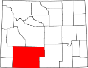
Towns CDPs Arrowhead Springs | Clearview Acres | Eden | Farson | James Town | Little America | McKinnon | North Rock Springs | Point of Rocks | Purple Sage | Reliance | Sweeney Ranch | Washam
Unincorporated
communityGhost towns Bryan | Table Rock | Winton
Categories:- National Register of Historic Places in Wyoming by county
- Sweetwater County, Wyoming
-


Wikimedia Foundation. 2010.