- Detroit River Light
-
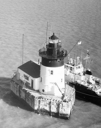
Detroit River Light 
Undated U.S.C.G. photo Location Lake Erie
south of Detroit RiverYear first constructed 1875 (lightship)
1885 (current tower)Automated 1979 Foundation Wood/cement crib
Granite pierConstruction Cast iron with brick lining Tower shape frustum of a cone with attached building.[1] Markings / pattern White with black top Height 49 feet (15 m) Original lens 4th order Fresnel lens Range 10 nautical miles (19 km; 12 mi) Characteristic Fl(2) W 6s Fog signal Horn: 1 every 30s Racon "X" (X-ray) ARLHS number USA-227[2][3] USCG number 6885[4][5][6] Detroit River Light Station

Nearest city: Rockwood, Michigan[8] Coordinates: 42°0′2.70″N 83°8′26.45″W / 42.00075°N 83.1406806°WCoordinates: 42°0′2.70″N 83°8′26.45″W / 42.00075°N 83.1406806°W Area: 0.1 acres (0.040 ha) Built: 1884 Architect: Davis C.E.L.B. Governing body: U.S. Coast Guard MPS: U.S. Coast Guard Lighthouses and Light Stations on the Great Lakes TR NRHP Reference#: 83000886[7] Added to NRHP: August 04, 1983 The Detroit River Light, also known as Bar Point Shoal Light, was first established as a lightship in 1875. The current sparkplug lighthouse was built in 1885.[6] It sits in Lake Erie, south of the mouth of the Detroit River, 1.75 nautical miles (2.01 mi; 3.24 km) from land and about 20 nautical miles (23 mi; 37 km) from the Ambassador Bridge in the Detroit River. It is about 0.4 nautical miles (810 yd; 740 m) from the border with Canada,[9] and just under 24 nautical miles (28 mi; 44 km) from Put-in-Bay, Ohio.[10] Its original 4th order Fresnel lens is on loan to the Michigan Maritime Museum.[4]
Contents
Construction and infrastructure
The Detroit River Light replaced a Canadian lightship that had been posted in this channel location since 1875, guiding upbound vessels making a turn in the Detroit River.
The United States Lighthouse Board completed the Detroit River Light in 1885 at a cost of $78,000. The Light was first lit on August 20, 1885.[11]
The crib was transported to the site from Amherstburg, Ontario. It was built pre-fabricated 45 by 18 feet (14 by 5.5 m), sunk in 22 feet (6.7 m) of water, filled with concrete and surrounded by a granite pier. The light station pier is shaped like a vessel. Its pointed end is directed toward the mouth of the river to break river-powered ice floes. Above the crib and pier, the 49 feet (15 m) high cast iron boiler plate tower is 22 feet (6.7 m) in diameter at its base and 18 feet (5.5 m) up top.[11] There is an attached storage building and radio beacon.[12]
Challenges in construction
Construction was eventful and problematical. When the crib settled, it was uneven, about 16 inches (41 cm) off level. As winter was approaching and work set to stop, 550 short tons of stone were loaded onto the pier, "mostly on the high side." Upon the crews return the following spring, gravity and ice floes had made the granite pier level.[13][14]
Operational history
Detroit River Light was constructed to be a manned lighthouse. Coast Guardsmen assigned to this close-but-eerily-isolated station used to refer to it as "The Rock."[14] The light is now automated.
With Prohibition the light served as a rendezvous point for rum runners.[13] The nearby city of Windsor was a noted point for the distillation of Canadian whiskey, much of which was exported to the U.S.
The light today
In December 1997 the 635-foot (194 m) freighter M/V Buffalo[15] struck the station dead on (a "direct hit"[16]) as it sailed down bound for Lake Erie. The station suffered minimal damage to rock and stone foundation. The freighter had its steel bow pushed "in like a tin can" with a 25-foot (7.6 m) gash.[11][17]
The lens has been changed several times, and this has altered the characteristic signal generated by the light to passing boats and ships. The present lens has six panels of 60 degrees, with three bull's-eye panels each separated from the other by a 60 degree blind panel.
The station contains a fog signal, similar to Harbor Beach Light (also built in 1885). The station is an active aid to navigation, is closed to visitors, and visible only from a boat.[11] A good launch point is the south end of the island of Grosse Ile, Michigan.[18]
It was added to the National Register of Historic Places as Detroit River Light Station on August 4, 1983, reference number 83000886.[7]
The light has been memorialized in sculptures.[13]
Keepers
- Charles Northup (1885–1886 and 1893–1898)
- Richard Oddrey (1887–1890)
- Joseph Crawford (1898–1902)
- Enoch Scribner (1902–1912)
- Horace Watts (1912–1916)
- Walter Marshall (1916–1919)
- Harry K Condway (1919–1921)
- John Sweet (1926–1933)
- William Small (1933–1938)
- Eli Martin (1938–1939)[6]
References
- ^ Pepper, Terry. "Database of Lighthouse Types and Tower Shapes". Seeing the Light. terrypepper.com. http://www.terrypepper.com/lights/lists/towertype.htm.
- ^ Amateur Radio Lighthouse Society, Bar Point Shoal/Detroit River Light ARLHS USA-227.
- ^ Amateur Radio Lighthouse Society, World List of Lights.
- ^ a b Rowlett, Russ (2009-11-13). "Lighthouses of the United States: Michigan's Eastern Lower Peninsula". The Lighthouse Directory. University of North Carolina at Chapel Hill. http://www.unc.edu/~rowlett/lighthouse/miel.htm.
- ^ (PDF) Light List, Volume VII, Great Lakes. Light List. United States Coast Guard. 2009. p. 74. http://www.navcen.uscg.gov/pdf/lightLists/LightList%20V7.pdf.
- ^ a b c "Historic Light Station Information and Photography: Michigan". United States Coast Guard Historian's Office. http://www.uscg.mil/history/weblighthouses/LHMI.asp.
- ^ a b "National Register Information System". National Register of Historic Places. National Park Service. 2009-03-13. http://nrhp.focus.nps.gov/.
- ^ Certain documents list the Detroit River Light as being part of or being closest to the city of Rockwood, Michigan. As the closest city, Rockwood is in Wayne County, but the lighthouse is within the northernmost water boundaries of Berlin Charter Township in Monroe County. However, the Detroit River Light is owned and operated by the United States Coast Guard and is therefore not under the jurisdiction of any municipality.
- ^ NOAA Chart 14848 Detroit River Michigan Extension
- ^ Photo of Detroit River Light.
- ^ a b c d Wobser, David, Bar Point Shoal Lighthouse at boatnerd.com
- ^ "Detroit River Lighthouse". Michigan Lighthouse Conservancy. http://www.michiganlights.com/detroitriverlh.htm.
- ^ a b c Harbour Lights, Detroit River Lighthouse
- ^ a b Greenwood, Tom, Detroit River Light (September, 1998) Lighthouse Digest.
- ^ Photo of M/V Buffalo at boatnerd.com.
- ^ Roach, Jerry, Lighthouse Central, Detroit River Lighthouse Photographs, History and Directions, The Ultimate Guide to East Michigan Lighthouses (Publisher: Bugs Publishing LLC - July 2006). ISBN 0-9747977-1-5; ISBN 978-0-9747977-1-7.
- ^ Photo of damage to S.S. Buffalo at boatnerd.com.
- ^ Anderson, Kraig, Lighthouse Friends, Detroit River Lighthouse.
Specialized further reading
- Greenwood, Tom, Detroit River Light (September, 1998) Lighthouse Digest.
- Nolan, Jenny, How the Detroit River shaped lives and history (February 11, 1997), Detroit News.
External links
- Aerial photo of Detroit River Lighthouse at marinas.com.
- Satellite view of Detroit River (Bar Point Shoal) Lighthouse at Google maps.
- Colchester Reef Light (Lake Erie, West)
Lighthouses of Michigan See also: List of lighthouses in MichiganNorthern upper peninsula Au Sable Light • Big Bay Point Light • Copper Harbor Light • Copper Harbor Front Range Light • Crisp Point Light • Eagle Harbor Light • Eagle Harbor Range Lights • Eagle River Light • Fourteen Mile Point Light • Grand Island East Channel Light • Grand Island Harbor Rear Range Light • Grand Island North Light • Granite Island Light • Gull Rock Light Station • Huron Island Light • Isle Royale Light • Manitou Island Light Station • Marquette Harbor Light • Mendota (Bete Grise) Light • Munising Front Range Light • Munising Rear Range Light • Portage River (Jacobsville) Light • Passage Island Light • Rock Harbor Light • Rock of Ages Light • Sand Hills Light • St. Martin Island Light • Stannard Rock Light • Thunder Bay Island Light • Whitefish Point LightSouthern upper peninsula DeTour Reef Light • Manistique East Breakwater Light • Martin Reef Light • Menominee Pier Light • Naubinway Island Light • Peninsula Point Light • Poverty Island Light • Sand Point Light Escanaba • Sand Point Light Baraga • Seul Choix Light • Squaw Island Light • White Shoal LightSt. Mary's River Frying Pan Island Light • Pipe Island Light • Point Iroquois Light • Round Island Light (St. Mary's River) • Six Mile Point Range Rear LightPortage River/Ship Canal Keweenaw Waterway (Portage Lake) Lower Entrance • Keweenaw Waterway Upper Entrance Light • Rouleau Point Range Front and Rear LightsStraits of Mackinac Bois Blanc Light • McGulpin Point Light • Old Mackinac Point Light • Round Island Light • Round Island Passage • St. Helena Island LightWestern lower peninsula Beaver Island Harbor Light • Beaver Island Head Light • Big Sable Point Light • Charlevoix Light • Charlevoix South Pier Light • Frankfort Light • Frankfort South Range Light • Grand Haven Light • Grand Haven South Pierhead Outer Light • Grand Haven Main Light • Gray's Reef Light • Holland Harbor Light • Ile Aux Galets • Little Sable Point Light • Little Traverse Light • Ludington Light • Manistee Main Light • Manistee Pierhead lights • Miller Memorial Light • Mission Point Light • Mission Point Light (2) • Muskegon Breakwater Light • Muskegon Pier Light • Point Betsie Light • South Fox Island • South Haven Light • South Manitou Island Light • Waugoshance Light • White River LightEastern lower peninsula Alpena Light • Bellanger Park (Ecorse) Light • Caseville Harbor (Saginaw Bay) • Belle Isle Light • Charity Island Light • Cheboygan River Range Front Light • Cheboygan Crib Light • Detroit River Light • Fort Gratiot Light • Forty Mile Point Light • Fourteen Foot Shoal Light • Gibraltar Light • Gravelly Shoal Light • Harbor Beach Light • Manning Memorial Light • Mariners Memorial (River Rouge) Light • New Presque Isle Light • Old Presque Isle Light • Poe Reef Light • Pointe aux Barques Light • Port Austin Light • Port Sanilac Light • Saginaw River Range Front Light • Saginaw River Rear Range Light • Spectacle Reef Light • St. Clair Flats Front and Rear Range Light • Sturgeon Point Light • Tawas Point Light • Tri-Centennial Light of Detroit • William Livingtone Memorial LightHistorical (lost) lights Au Sable North Pierhead • Clinton River Light • Ecorse Light • Ecorse Range Rear • Gibraltar Light • Grassy Island Lighthouse • Grassy Island North Channel Range • Grassy Island South Channel Range • Grosse Isle South Channel Range • Harwood Point East Range Front (St. Mary's River) • Mama Juda Light • Mama Juda Range Front • Middle Lake George • Monroe Pier • New Buffalo • North Manitou Island • Rouleau Point Range Front and Rear • Saginaw Bay • Sand Beach North Entrance East • Squaw Point • St. Mary's River Lower Range Front • Turtle Island Light • Vidal Shoals Channel Range Front and Rear • Windmill Point Range Front and Rear • Winter Point Range FrontRelated – Lightship Huron, List of lifesaving stations in MichiganNational Register of Historic Places in Monroe County, Michigan Historic districts Dundee Historic District | East Elm-North Macomb Street Historic District | North Maumee Bay Archeological District | Old Village Historic District | St. Mary's Church Complex Historic District

Historic properties Detroit River Light Station | Edward Loranger House | George Armstrong Custer Equestrian Monument | Governor Robert McClelland House | Jefferson Avenue-Huron River Bridge | Navarre-Anderson Trading Post | River Raisin National Battlefield Park | Rudolph Nims House | Sawyer House | Weis Manufacturing Company
Contributing properties Old Mill Museum | St. Mary Catholic Central High School
U.S. National Register of Historic Places Topics Lists by states Alabama • Alaska • Arizona • Arkansas • California • Colorado • Connecticut • Delaware • Florida • Georgia • Hawaii • Idaho • Illinois • Indiana • Iowa • Kansas • Kentucky • Louisiana • Maine • Maryland • Massachusetts • Michigan • Minnesota • Mississippi • Missouri • Montana • Nebraska • Nevada • New Hampshire • New Jersey • New Mexico • New York • North Carolina • North Dakota • Ohio • Oklahoma • Oregon • Pennsylvania • Rhode Island • South Carolina • South Dakota • Tennessee • Texas • Utah • Vermont • Virginia • Washington • West Virginia • Wisconsin • WyomingLists by territories Lists by associated states Other Categories:- Lighthouses in Michigan
- National Register of Historic Places in Michigan
- Buildings and structures completed in 1884
- Michigan State Historic Sites
- Buildings and structures in Monroe County, Michigan
- Transportation in Monroe County, Michigan


Wikimedia Foundation. 2010.