- Old Mackinac Point Light
-
Old Mackinac Point Light 
Location Mackinaw City, Michigan Year first constructed 1892 Year first lit 1892 Deactivated 1957 Foundation Ashlar limestone[1] Construction Cream City Brick Tower shape Cylindrical "Castle" with attached dwelling[2] Markings / pattern Natural with black lantern Height Tower - 50 feet (15 m)[2][3] Focal height Focal Plane - 62 feet (19 m)[4] Original lens Fourth order Fresnel lens Range 16 miles (26 km)[5] ARLHS number USA-463[6][7] Mackinac Point Lighthouse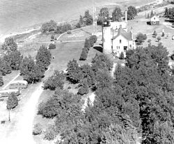 Vintage image of the station
U.S. Coast Guard photo

Location: Michilimackinac State Park, Mackinaw City, Michigan Coordinates: 45°47′15″N 84°43′46″W / 45.7875°N 84.72944°WCoordinates: 45°47′15″N 84°43′46″W / 45.7875°N 84.72944°W Area: 0.9 acres (3,600 m2) Built: 1892 Governing body: Mackinac Island State Park Commission NRHP Reference#: 69000068[8] Added to NRHP: October 1, 1969 Mackinaw Point marks the junction of Lake Michigan and Lake Huron. Founded in 1889, the Old Mackinac Point Light Station was in operation from 1890 until 1957.[9]
Contents
History
Preparations
Even before the advent of European explorers, the Straits of Mackinac were a significant hazard to water borne travelers. Consequently, before lighthouses, the Ojibwa lit the shore with fires.[10]
In the early 19th century, with large vessel traffic increasing from Lake Huron into the Straits, the first step in guarding the Straits was taken in 1829, through the construction of Bois Blanc Lighthouse to both guide mariners in making the westerly turn into the Straits, and to warn them of the shoals and shallows surrounding the island.
Three years later in 1832, Congress acted on Stephen Pleasonton’s recommendation that a lightship be placed on Waugoshance Shoal as the first attempt to mark the western entrance to the Straits. In 1838, Lieutenant James T. Homans reported that the lightship was wholly inadequate. He recommended a better solution for Waugoshance and also that a light be built on the point to the west of Mackinaw Harbor. Nothing came of Homans' recommendations. In 1854, the new Lighthouse Administration decided (against the recommendation of local residents) to put a light at McGulpin Point, approximately 3 miles (4.8 km) to the west of Old Point Mackinaw.
Construction
In 1889, the United States Lighthouse Board realized that Mackinaw Point was a better location. Their first inclination was to put a fog signal there, but when asking Congress for funding, they requested funding for both a fog signal and a first class lighthouse. Congress chose to accept their recommendation, but only voted the funding for a steam-powered fog-signal. The fog signal was built in 1890.[11] The signal proved to be exceptionally necessary for navigation in the often fog-choked Straits of Mackinac; during one exceptionally humid fortnight, the Old Mackinac Point signal personnel reported burning 52 cords of stovewood in order to keep steam up for the foghorn.[12]
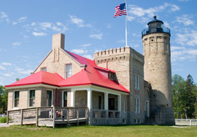
The lighthouse "grew out of the fog station."[2][13] In March 1891, Congress finally authorized the funding for a light station and the board acted quickly. Bidding was difficult, but in 1892, "on a foundation of ashlar limestone, the tower and attached keeper’s dwelling were both constructed of Cream City brick, trimmed with Indiana Limestone. The double-walled cylindrical tower was laid with an outside diameter of 13 feet 4 inches (4.06 m), and as each course was added, rose to a height of 45 feet (14 m), surmounted by a circular iron gallery and an 8-foot-8-inch (2.64 m) diameter watch room, which was in turn capped by a prefabricated octagonal iron lantern."[14] The lens is a fourth order Fresnel Lens.
Its light was visible for 16 miles (26 km), which made it "particularly valuable" to the railroad car ferries SS Chief Wawatam and St. Ignace.[5]
Deactivation and preservation
The completion of the Mackinac Bridge in 1957 eliminated the need for the light. Since the Mackinac Bridge has lights on it at night, the bridge became a much better aid to navigation than the light.
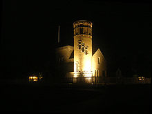 The light as seen at night
In 1960, the lighthouse property was purchased by the Mackinac Island State Park Commission, incorporating it into surrounding Michilimackinac State Park. The Old Mackinac Point Lighthouse was added to the National Register of Historic Places in November 1969, as Reference #69000068 (listed as: Mackinac Point Lighthouse).[13]
It is also a registered Michigan Historic Landmark. The Michigan Historical Marker on site states:
- Mackinac Point Lighthouse.[13] The lighthouse complex, including the lightkeeper's quarters and tower, was reopened to the public in 2004 by Mackinac State Historic Parks as part of the Fort Michilimackinac complex. The light's original Fresnel lens is on display. An admission fee is charged.
A state historical marker was erected in 1972. It is Registered Site S0377. The marker states:
- This lighthouse is opposite the turning point for ships making the difficult passage through the Straits of Mackinac, one of the busiest crossroads of the Great Lakes. McGulpin Point Light, two miles (3 km) to the west, had been established in 1856, but it was not visible from all directions. In 1889 Congress appropriated funds for the construction of a steam-powered fog signal here, which went into operation on November 5, 1890. Construction of the light tower and attached lightkeepers' dwelling began, and the light was first displayed on October 25, 1892. Heavy iron and brass castings were used throughout the structure, and the light was visible to ships sixteen miles away. In operation until 1958, the lighthouse is now a maritime museum.[15]
In 2000, serious restoration was undertaken, with the intent of restoring it to its appearance around 1910. The lighthouse is reopened to the public, and the castle-style structure, which design is unique in the Great Lakes was restored.[16] the first floor is fully accessible, and includes period furnishings and accoutrement, plus hands-on exhibits that test one's nighttime navigation skills, light a miniature Fresnel lens, and put on Lighthouse keeper clothing. Historic interpreters lead tours up the tower and into the lantern room.[5]
Current status and getting there
Adjacent to the Mackinac Bridge, the park offers a good view of the bridge and boat traffic.[5]
Admission is through the 1907 Fog Signal Building, which houses the museum store. An admission fee is charged. Pets are welcome.
The tower is open to the public.[17]
The lighthouse is located within Michilimackinac State Park, just a few hundred feet east of the Mackinac Bridge and the Colonial Michilimackinac Visitors Center. At this time the light is a museum run by Mackinac Parks Commission.
Because of its prime location and exposure to tourists, plus its unique picturesque form and color, it is the subject of photographs,[18] drawings, and needlepoint illustrations.[19] Historical photographs are a prominent feature of the Mackinac Island State Park Commission website.[20]
An exciting and expensive alternative is to charter a seaplane to make a tour of the Mackinac Straits and environs.[21]
See also
- Great Lakes Storm of 1913
- Shipwrecks of the 1913 Great Lakes storm
- List of victims of the 1913 Great Lakes storm
- Lighthouses in the United States
Specialized further reading
- "A Tour of the Lights of the Straits." Michigan History 70 (Sep/Oct 1986), pp. 17–29.
- Brisson, Steven (2001) Brief history, Old Mackinac Point Lighthouse, Mackinac Parks, Mackinac Island State Park Commission. Adapted from: Old Mackinac Point Light Station. Mackinac History: A Continuing Series of Illustrated Vignettes. Vol. III, no. 5. Mackinac Island: Mackinac Island State Park Commission.
- Brisson, Steven C. (Mackinac State Historic Parks chief curator). Old Mackinac Point Lighthouse: A History & Pictorial Souvenir (1/29/2008).[22]
- Hyde, Charles K., and Ann and John Mahan. The Northern Lights: Lighthouses of the Upper Great Lakes. Detroit: Wayne State University Press, 1995. pp. 36–46. ISBN 0814325548 ISBN 9780814325544.
- Pepper, Terry. "Old Mackinac Point Light". Seeing The Light. terrypepper.com. http://www.terrypepper.com/Lights/huron/mackinac/index.htm.
References
- ^ Brisson, Steven (2001) Brief history, Old Mackinac Point Lighthouse, Mackinac Parks, Mackinac Island State Park Commission.
- ^ a b c Michigan Lighthouse Conservancy, Old Mackinac Point Light.
- ^ Pepper, Terry. "Database of Tower Heights". Seeing the Light. terrypepper.com. http://www.terrypepper.com/lights/lists/towers.htm.
- ^ Pepper, Terry. "Database of Focal Heights". Seeing the Light. terrypepper.com. http://www.terrypepper.com/lights/lists/focalheight.htm.
- ^ a b c d Wobser, David. "Old Mackinac Point". Boatnerd.com. http://lighthouse.boatnerd.com/gallery/Huron/OldMac.htm.
- ^ Amateur Radio Lighthouse Society Old Mackinac Point (Straits of Mackinac) Light, ARLHS USA-463.
- ^ Amateur Radio Lighthouse Society, World List of Lights (WLOL).
- ^ "National Register Information System". National Register of Historic Places. National Park Service. 2009-03-13. http://nrhp.focus.nps.gov/natreg/docs/All_Data.html.
- ^ Old Mackinac Point Lighthouse, official website.
- ^ Old Mackinac Point Lighthouse. How Stuff Works.
- ^ Lighthouse Central, Old Mackinac Point light The Ultimate Guide to East Michigan Lighthouses by Jerry Roach (Publisher: Bugs Publishing LLC - July 2006). ISBN 0974797715; ISBN 9780974797717.
- ^ Roberts, Bruce; Jones, Ray. (September 2002) American Lighthouses, 2nd: A Definitive Guide p. 250 Publisher: Globe Pequot Press 304 pp ISBN 1592231020; ISBN 978-1592231027; ISBN 9780762722693.
- ^ a b c National Park Service Maritime History Project, Inventory of Historic Lights, Old Mackinac Point Lighthouse.
- ^ Pepper, Terry. "Old Mackinac Point Light". Seeing The Light. terrypepper.com. http://www.terrypepper.com/Lights/huron/mackinac/index.htm.
- ^ Michigan Historical Markers, Old Mackinac Point Light.
- ^ Rowlett, Russ. "Lighthouses of the United States: Michigan's Eastern Lower Peninsula". The Lighthouse Directory. University of North Carolina at Chapel Hill. http://www.unc.edu/~rowlett/lighthouse/miel.htm.
- ^ Old Mackinac Point Light, Detroit News.
- ^ Light house friends, Old Mackinac Point Lighthouse.
- ^ Needlepoint of Mackinac Point Light.
- ^ Historical photographs of Old Mackinac Point Light.
- ^ Stoke, Keith, A seaplane tour of the Straits.
- ^ Old Mackinac Point Light Press Release.
External links
- Aerial photos, Old Mackinac Point Light, marinas.com.
- Huelse, Klaus -- Meine Leuchtturm-Seite: Leuchttürme USA auf historischen Postkarten -- Historic postcard images of U.S. lighthouses, Historic Post Card View — Old Mackinac Point Lighthouse.
- Interactive map of lighthouses in northern Lake Michigan.
- Lake Huron Northern Lighthouses Mapped by Google
- Lighthouses in the Mackinac Straits, Lighthouse Friends.
- List and information for lighthouses in northern Lake Michigan.
- Mackinac Parks, Old Mackinac Point Lighthouse, official website.
- Satellite view, Google maps.
Lighthouses of Michigan See also: List of lighthouses in MichiganNorthern upper peninsula Au Sable Light • Big Bay Point Light • Copper Harbor Light • Copper Harbor Front Range Light • Crisp Point Light • Eagle Harbor Light • Eagle Harbor Range Lights • Eagle River Light • Fourteen Mile Point Light • Grand Island East Channel Light • Grand Island Harbor Rear Range Light • Grand Island North Light • Granite Island Light • Gull Rock Light Station • Huron Island Light • Isle Royale Light • Manitou Island Light Station • Marquette Harbor Light • Mendota (Bete Grise) Light • Munising Front Range Light • Munising Rear Range Light • Portage River (Jacobsville) Light • Passage Island Light • Rock Harbor Light • Rock of Ages Light • Sand Hills Light • St. Martin Island Light • Stannard Rock Light • Thunder Bay Island Light • Whitefish Point LightSouthern upper peninsula DeTour Reef Light • Manistique East Breakwater Light • Martin Reef Light • Menominee Pier Light • Naubinway Island Light • Peninsula Point Light • Poverty Island Light • Sand Point Light Escanaba • Sand Point Light Baraga • Seul Choix Light • Squaw Island Light • White Shoal LightSt. Mary's River Frying Pan Island Light • Pipe Island Light • Point Iroquois Light • Round Island Light (St. Mary's River) • Six Mile Point Range Rear LightPortage River/Ship Canal Keweenaw Waterway (Portage Lake) Lower Entrance • Keweenaw Waterway Upper Entrance Light • Rouleau Point Range Front and Rear LightsStraits of Mackinac Bois Blanc Light • McGulpin Point Light • Old Mackinac Point Light • Round Island Light • Round Island Passage • St. Helena Island LightWestern lower peninsula Beaver Island Harbor Light • Beaver Island Head Light • Big Sable Point Light • Charlevoix Light • Charlevoix South Pier Light • Frankfort Light • Frankfort South Range Light • Grand Haven Light • Grand Haven South Pierhead Outer Light • Grand Haven Main Light • Gray's Reef Light • Holland Harbor Light • Ile Aux Galets • Little Sable Point Light • Little Traverse Light • Ludington Light • Manistee Main Light • Manistee Pierhead lights • Miller Memorial Light • Mission Point Light • Mission Point Light (2) • Muskegon Breakwater Light • Muskegon Pier Light • Point Betsie Light • South Fox Island • South Haven Light • South Manitou Island Light • Waugoshance Light • White River LightEastern lower peninsula Alpena Light • Bellanger Park (Ecorse) Light • Caseville Harbor (Saginaw Bay) • Belle Isle Light • Charity Island Light • Cheboygan River Range Front Light • Cheboygan Crib Light • Detroit River Light • Fort Gratiot Light • Forty Mile Point Light • Fourteen Foot Shoal Light • Gibraltar Light • Gravelly Shoal Light • Harbor Beach Light • Manning Memorial Light • Mariners Memorial (River Rouge) Light • New Presque Isle Light • Old Presque Isle Light • Poe Reef Light • Pointe aux Barques Light • Port Austin Light • Port Sanilac Light • Saginaw River Range Front Light • Saginaw River Rear Range Light • Spectacle Reef Light • St. Clair Flats Front and Rear Range Light • Sturgeon Point Light • Tawas Point Light • Tri-Centennial Light of Detroit • William Livingtone Memorial LightHistorical (lost) lights Au Sable North Pierhead • Clinton River Light • Ecorse Light • Ecorse Range Rear • Gibraltar Light • Grassy Island Lighthouse • Grassy Island North Channel Range • Grassy Island South Channel Range • Grosse Isle South Channel Range • Harwood Point East Range Front (St. Mary's River) • Mama Juda Light • Mama Juda Range Front • Middle Lake George • Monroe Pier • New Buffalo • North Manitou Island • Rouleau Point Range Front and Rear • Saginaw Bay • Sand Beach North Entrance East • Squaw Point • St. Mary's River Lower Range Front • Turtle Island Light • Vidal Shoals Channel Range Front and Rear • Windmill Point Range Front and Rear • Winter Point Range FrontRelated – Lightship Huron, List of lifesaving stations in MichiganU.S. National Register of Historic Places Topics Lists by states Alabama • Alaska • Arizona • Arkansas • California • Colorado • Connecticut • Delaware • Florida • Georgia • Hawaii • Idaho • Illinois • Indiana • Iowa • Kansas • Kentucky • Louisiana • Maine • Maryland • Massachusetts • Michigan • Minnesota • Mississippi • Missouri • Montana • Nebraska • Nevada • New Hampshire • New Jersey • New Mexico • New York • North Carolina • North Dakota • Ohio • Oklahoma • Oregon • Pennsylvania • Rhode Island • South Carolina • South Dakota • Tennessee • Texas • Utah • Vermont • Virginia • Washington • West Virginia • Wisconsin • WyomingLists by territories Lists by associated states Other Categories:- Lighthouses on the National Register of Historic Places
- Michigan State Historic Sites
- Lighthouses in Michigan
- National Register of Historic Places in Michigan
- Lighthouse museums in Michigan
- Museums in Cheboygan County, Michigan
- Buildings and structures completed in 1892


Wikimedia Foundation. 2010.