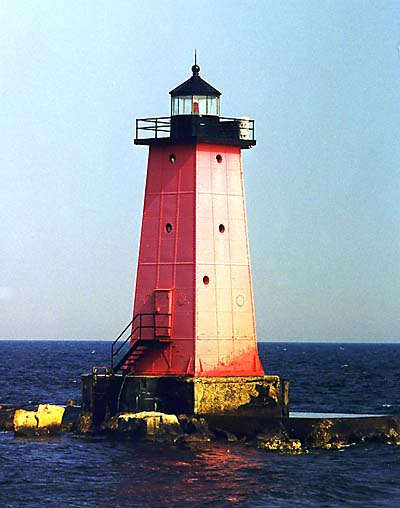
- Manistique East Breakwater Light
-
Manistique East Breakwater Light 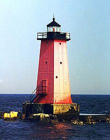
Manistique Breakwater Lighthouse Location Manistique, Michigan Coordinates 45°56′41″N 86°14′50″W / 45.9446°N 86.2472°WCoordinates: 45°56′41″N 86°14′50″W / 45.9446°N 86.2472°W Year first lit 1916 Automated 1969 Foundation Concrete pier Construction Steel Tower shape Square pyramidal[1] Markings / pattern Red with black lantern[1] Original lens Fourth-order Fresnel (original) ARLHS number USA-469 USCG number 7-21475 Manistique East Breakwater LightArea: less than one acre Governing body: Federal MPS: Light Stations of the United States MPS NRHP Reference#: 05000980[2] Added to NRHP: September 6, 2005 The Manistique Breakwater lighthouse is located in the harbor of Manistique, Michigan.[1] It was listed on the National Register of Historic Places in 2005.[2]
History
At the beginning of the 20th century, Manistique was a boom town, with timber and pig iron shipping from the harbor daily.[3] However, the harbor itself was protected only be timber crib piers origininally constructed in the 1870s. However, by 1910, leaders in Manistique managed to convince the Federal government of the financial importance of the harbor, and an Army Corps of Engineers harbor expert was sent to Manistique to draw up plans for a concrete breakwater structure. The contract to construct the breakwaters was awarded to the Greiling Brothers Company, and construction was started in 1910.[3]
At the same time, George Putnam, the newly appointed Commissioner of lighthouses, recommended the erection of lights on the breakwater.[3] In 1912, the Lighthouse Service erected temporary range lights on one of the piers. Funding for permanent lights was approved in 1913, and by 1914 permanent lights on the west breakwater were complete. The east breakwater itself was not completed until 1915, at which time work began on the east breakwater light and a station keeper's house at the foot of the breakwater. Construction was completed in August, and the new light was lit on August 17, 1916.[3]
As the century progressed, Manistique's importance as a port waned. The light was automated in 1969, and the original Fourth Order Fresnel lens was replaced with a 300 mm Tidelands Signal acrylic optic.[3] In 2000, the Corps of Engineers replaced the concrete breakwater with rip rap.[1]
References
- ^ a b c d "Historic Light Station Information and Photography: Michigan". United States Coast Guard Historian's Office. http://www.uscg.mil/history/weblighthouses/LHMI.asp.
- ^ a b "National Register Information System". National Register of Historic Places. National Park Service. 2010-07-09. http://nrhp.focus.nps.gov/natreg/docs/All_Data.html.
- ^ a b c d e Terry Pepper (06/20/2004). "Manistique East Breakwater Light". Seeing the Light. http://www.terrypepper.com/lights/michigan/manistique/manistique.htm. Retrieved November 19, 2011.
External links
- Lighthouse Central, Manistique East Breakwater light The Ultimate Guide to Upper Michigan Lighthouses by Jerry Roach. (Publisher: Bugs Publishing LLC - 2007). ISBN 978-0-9747977-2-4.
- Rowlett, Russ. "Lighthouses of the United States: Michigan's Eastern Upper Peninsula". The Lighthouse Directory. University of North Carolina at Chapel Hill. http://www.unc.edu/~rowlett/lighthouse/miup.htm.
Lighthouses of Michigan See also: List of lighthouses in Michigan Northern upper peninsula Au Sable Light • Big Bay Point Light • Copper Harbor Light • Copper Harbor Front Range Light • Crisp Point Light • Eagle Harbor Light • Eagle Harbor Range Lights • Eagle River Light • Fourteen Mile Point Light • Grand Island East Channel Light • Grand Island Harbor Rear Range Light • Grand Island North Light • Granite Island Light • Gull Rock Light Station • Huron Island Light • Isle Royale Light • Manitou Island Light Station • Marquette Harbor Light • Mendota (Bete Grise) Light • Munising Front Range Light • Munising Rear Range Light • Portage River (Jacobsville) Light • Passage Island Light • Rock Harbor Light • Rock of Ages Light • Sand Hills Light • St. Martin Island Light • Stannard Rock Light • Thunder Bay Island Light • Whitefish Point LightSouthern upper peninsula DeTour Reef Light • Manistique East Breakwater Light • Martin Reef Light • Menominee Pier Light • Naubinway Island Light • Peninsula Point Light • Poverty Island Light • Sand Point Light Escanaba • Sand Point Light Baraga • Seul Choix Light • Squaw Island Light • White Shoal LightSt. Mary's River Frying Pan Island Light • Pipe Island Light • Point Iroquois Light • Round Island Light (St. Mary's River) • Six Mile Point Range Rear LightPortage River/Ship Canal Keweenaw Waterway (Portage Lake) Lower Entrance • Keweenaw Waterway Upper Entrance Light • Rouleau Point Range Front and Rear LightsStraits of Mackinac Bois Blanc Light • McGulpin Point Light • Old Mackinac Point Light • Round Island Light • Round Island Passage • St. Helena Island LightWestern lower peninsula Beaver Island Harbor Light • Beaver Island Head Light • Big Sable Point Light • Charlevoix Light • Charlevoix South Pier Light • Frankfort Light • Frankfort South Range Light • Grand Haven Light • Grand Haven South Pierhead Outer Light • Grand Haven Main Light • Gray's Reef Light • Holland Harbor Light • Ile Aux Galets • Little Sable Point Light • Little Traverse Light • Ludington Light • Manistee Main Light • Manistee Pierhead lights • Miller Memorial Light • Mission Point Light • Mission Point Light (2) • Muskegon Breakwater Light • Muskegon Pier Light • Point Betsie Light • South Fox Island • South Haven Light • South Manitou Island Light • Waugoshance Light • White River LightEastern lower peninsula Alpena Light • Bellanger Park (Ecorse) Light • Caseville Harbor (Saginaw Bay) • Belle Isle Light • Charity Island Light • Cheboygan River Range Front Light • Cheboygan Crib Light • Detroit River Light • Fort Gratiot Light • Forty Mile Point Light • Fourteen Foot Shoal Light • Gibraltar Light • Gravelly Shoal Light • Harbor Beach Light • Manning Memorial Light • Mariners Memorial (River Rouge) Light • New Presque Isle Light • Old Presque Isle Light • Poe Reef Light • Pointe aux Barques Light • Port Austin Light • Port Sanilac Light • Saginaw River Range Front Light • Saginaw River Rear Range Light • Spectacle Reef Light • St. Clair Flats Front and Rear Range Light • Sturgeon Point Light • Tawas Point Light • Tri-Centennial Light of Detroit • William Livingtone Memorial LightHistorical (lost) lights Au Sable North Pierhead • Clinton River Light • Ecorse Light • Ecorse Range Rear • Gibraltar Light • Grassy Island Lighthouse • Grassy Island North Channel Range • Grassy Island South Channel Range • Grosse Isle South Channel Range • Harwood Point East Range Front (St. Mary's River) • Mama Juda Light • Mama Juda Range Front • Middle Lake George • Monroe Pier • New Buffalo • North Manitou Island • Rouleau Point Range Front and Rear • Saginaw Bay • Sand Beach North Entrance East • Squaw Point • St. Mary's River Lower Range Front • Turtle Island Light • Vidal Shoals Channel Range Front and Rear • Windmill Point Range Front and Rear • Winter Point Range FrontRelated – Lightship Huron, List of lifesaving stations in Michigan U.S. National Register of Historic Places Topics Lists by states Alabama • Alaska • Arizona • Arkansas • California • Colorado • Connecticut • Delaware • Florida • Georgia • Hawaii • Idaho • Illinois • Indiana • Iowa • Kansas • Kentucky • Louisiana • Maine • Maryland • Massachusetts • Michigan • Minnesota • Mississippi • Missouri • Montana • Nebraska • Nevada • New Hampshire • New Jersey • New Mexico • New York • North Carolina • North Dakota • Ohio • Oklahoma • Oregon • Pennsylvania • Rhode Island • South Carolina • South Dakota • Tennessee • Texas • Utah • Vermont • Virginia • Washington • West Virginia • Wisconsin • WyomingLists by territories Lists by associated states Other  Category:National Register of Historic Places •
  Portal:National Register of Historic PlacesCategories:
- Lighthouses in Michigan
- Buildings and structures in Schoolcraft County, Michigan
- National Register of Historic Places in Michigan
- United States lighthouse stubs
Wikimedia Foundation. 2010.