- Charlevoix South Pier Light Station
-
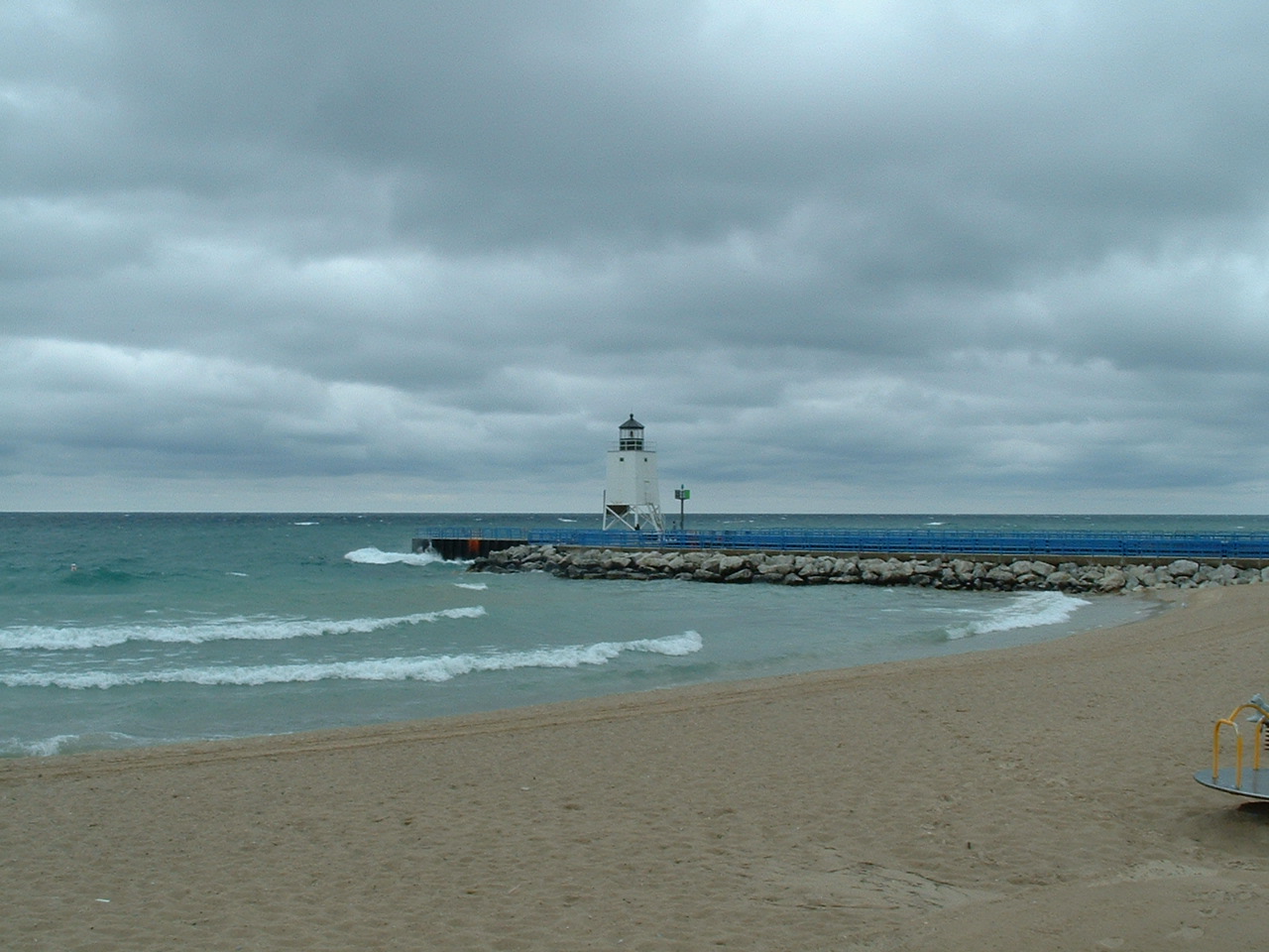
Charlevoix South Pier Light Station 
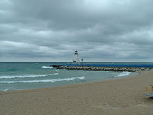
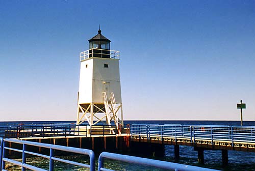
Charlevoix Lighthouse Location Charlevoix County, Michigan Coordinates 45°19′22″N 85°16′11″W / 45.32278°N 85.26972°WCoordinates: 45°19′22″N 85°16′11″W / 45.32278°N 85.26972°W Year first constructed 1947 Foundation pier Construction steel skeletal tower, upper 2/3 enclosed[1] Tower shape Square pyramid tower, decagonal lantern[2] Markings / pattern red Daymark/black lantern[3] Height Tower - 44 feet (13 m) Focal height Focal plane - Original lens Fifth Order Fresnel lens Current lens 300 mm Tideland Signal acrylic lens Range 10 nmi (19 km) Characteristic Flashing Red 4s HORN: 1 blast ev 30s (3s bl). Operates from May 1 to Oct. 20.[4]
ARLHS number USA-156[5][6] USCG number 7-17925 Charlevoiz South Pierhead Light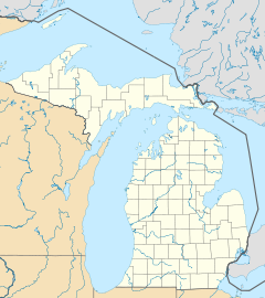

Location: S pier at harbor entrance, 0.3 WNW of US 31 drawbridge, Charlevoix, Michigan Coordinates: 45°19′13″N 85°15′54″W / 45.32028°N 85.265°WCoordinates: 45°19′13″N 85°15′54″W / 45.32028°N 85.265°W Area: less than 1-acre (4,000 m2) Built: 1948 Architect: US Coast Guard, Ninth District Governing body: COAST GUARD MPS: Light Stations of the United States MPS NRHP Reference#: 05000346[7] Added to NRHP: April 28, 2005 The Charlevoix South Pier Light Station is located on Lake Michigan at the entrance to Lake Charlevoix in Charlevoix County in the U.S. state of Michigan at the end of the south pier/breakwater of the channel leading to Round Lake in the city of Charlevoix.
Contents
History
The first light in Charlevoix was located on the north pier. It was built in 1884 in order to guide ships to the newly improved Pine River channel. A lifesaving station was built just north of the lighthouse in 1898 and an oil shed was built in 1890.[8] The first tower was 56 feet (17 m) tall,[9] with a 61 feet (19 m) focal height.[10]
The original structure survived for 63 years, but due to terminal deterioration the decision was made to replace it in 1947.[11] In 1948 the new steel structure was installed and the light was moved to its current location on the south pier where the lens and lantern from the old structure were transferred to the new one. The skeletal structure and general configuration of this light shares some design elements with the Alpena Light.[12] The South Pierhead light was originally painted Daymark red.[13]
In 1965, because the Pine River channel is near a congested area, the Coast Guard vacated the old U.S. Life-Saving Service Station (tearing down the shingled building), and relocated to the grounds of the old Lighthouse Supply Station.
In 1989, the present steel and concrete pier replaced the old wooden pier with its concrete covering. The present piers and revetments were constructed in the 1970s and 1980s. The construction is specially designed to withstand unusually forceful wave pressures, and to protect the harbor. As Terry Pepper wrote:
“ Constructed of driven steel piles with concrete and rock fill, wooden buffers were added where needed. These new piers were designed to incorporate hydrodynamic features to protect the harbor area. The rectangular gaps beyond the beach are intended to absorb and break-up inbound wave force, thereby reducing the swells that would travel from the big lake all the way up the channel into Round Lake. The Pine River Channel is believed to be unique in the entire world inasmuch as it has a two-way current. After severe westerly windstorms, waters pushed high into Lake Charlevoix will swiftly flow back out to meet other inbound currents. Small whirlpools and eddies at the harbor mouth are not uncommon, and whitecaps can frequently be observed within the channel on the calmest days. ” —Terry Pepper[14]
The skeletal north pierhead tower has since been removed.[13]
The 300 mm Tideland Signal acrylic lens is described as a medium range modern Great Lakes lens with a maximum range of 10 nmi (19 km).[15]
The North Pierhead Light is at coordinates 45 19 18 N 85 15 54 W, and its characteristic is Flashing Green 2.5 seconds. Its range is 10 nautical miles (19 km).[4] The current tower is 20 feet (6.1 m) and it is an active aid to navigation.[4] The former North tower's height is 56 feet (17 m), with a focal plane of 61 feet (19 m).[16]
Described as the Charlevoix South Pierhead Light (added 2005 - Structure - #05000346) and also known as the Charlevoix Pier Light, it is listed in the National Register of Historic Places.[17] Specifically, it is described as "S pier at harbor entrance, 0.3 WNW of US 31 drawbridge, Charlevoix". Although it was unmanned, the National Park System has recognized it as a "significant aid to navigation."[18]
In 2009 the light was again painted red in keeping with the mariner's alliterative Mnemonic "Red Right returning."[3] For unknown reasons, previous Daymark color schemes have been green, white.[3] or originally red (until 1968).[1][14][19] See Sea mark.
A primary vessel benefiting from the Charlevoix Light is the Beaver Island ferry.[2]
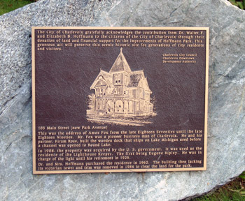
The land based lighthouse keeper's residence was sold to a private owner and demolished. The property became Hoffman Park, and all that remains is a metal plaque.[20]
In 2008, ownership of the light was transferred from the U.S. Coast Guard to the City of Charlevoix/Charlevoix Historical Society. The transfer was completed under the National Historic Lighthouse Preservation Act.[1][13]
See also
Notes
- ^ a b c Rowlett, Russ. "Lighthouses of the United States: Michigan's Western Lower Peninsula". The Lighthouse Directory. University of North Carolina at Chapel Hill. http://www.unc.edu/~rowlett/lighthouse/miwl.htm.
- ^ a b Wobser, David, Charlevoix South Pier Light Station at boatnerd.com.
- ^ a b c Lighthouses of Northern Lake Michigan at U.S. Lighthouses.
- ^ Amateur Radio Lighthouse Society, South Pier (Lake Michigan) Lighthouse ARLHS USA-156
- ^ Amateur Radio Lighthouse Society, World List of Lights (WLOL).
- ^ "National Register Information System". National Register of Historic Places. National Park Service. 2009-03-13. http://nrhp.focus.nps.gov/natreg/docs/All_Data.html.
- ^ "Historic Light Station Information and Photography: Michigan". United States Coast Guard Historian's Office. http://www.uscg.mil/history/weblighthouses/LHMI.asp.
- ^ Pepper, Terry. "Database of Tower Heights". Seeing the Light. terrypepper.com. http://www.terrypepper.com/lights/lists/towers.htm.
- ^ Pepper, Terry. "Database of Focal Heights". Seeing the Light. terrypepper.com. http://www.terrypepper.com/lights/lists/focalheight.htm.
- ^ Lighthouse Central, Photographs, History, Directions and Way points for Charlevoix South Pier Light Station, The Ultimate Guide to West Michigan Lighthouses by Jerry Roach (Publisher: Bugs Publishing LLC - 2005). ISBN 0-9747977-0-7.
- ^ Pepper, Terry. "Database of Tower Designs". Seeing the Light. terrypepper.com. http://www.terrypepper.com/lights/lists/towertype.htm.
- ^ a b c Michigan Lighthouse Conservancy, Charlevoix South Pierhead Light.
- ^ a b Terry Pepper, Seeing the Light, Charlevoix Light Station.
- ^ Tideland Signal lens, Terry Pepper, Seeing the Light.
- ^ Pepper, Terry. "Seeing the Light: Lighthouses on the western Great Lakes". http://www.terrypepper.com/lights/index.htm.
- ^ National Register of Historical Places.
- ^ National Park Service Maritime History Project, Inventory of Significant Unmanned Aids to Navigation, Charlevoix South Pier Light.
- ^ Antique Postcard (ca. 1955), South Pier Light with original red paint from Terry Pepper, Seeing the Light.
- ^ Anderson, Kraig, Lighthouse Friends, description Charlevoix South Pier Light.
Further reading
 Charlevoix Lights, north and south piers
- Harrison, Tim (editor of Lighthouse Digest and President of the American Lighthouse Foundation), (September, 2009) Ghost Lights of Michigan (Rare historic images and text on Michigan's lost and obscure lighthouse, including bonus chapters on lightships and lighthouse tenders.) East Machias, Maine: Foghorn Publishing, ISBN 978-0-9778293-3-0.
External links
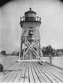 Old Charlevoix Light (note Fog bell), U. S. Coast Guard Archive
- Aerial photos, Charlevoix South Pier Light Station, marinas.com.
- Anderson, Kraig, Lighthouse Friends, description Charlevoix South Pier Light.
- Antique Postcard, South Pier Light after 1914 move from Terry Pepper, Seeing the Light.
- Antique (ca. 1955) Postcard, South Pier Light with original red paint from Terry Pepper, Seeing the Light.
- Charlevoix Historical Society website
- Charlevoix Historical Society, Keep the Light on website.
- Interactive map/list/information of lighthouses in northeastern Lake Michigan by LighthousesRus
- Michigan Lighthouse project, Charlevoix South Pier
- Keepers of the Charlevoix Light at Terry Pepper, Seeing the Light.
- Map of Michigan Lighthouses from Michigan.gov
- Terry Pepper, Seeing the Light, Charlevoix Light Station.
Lighthouses of Michigan See also: List of lighthouses in MichiganNorthern upper peninsula Au Sable Light • Big Bay Point Light • Copper Harbor Light • Copper Harbor Front Range Light • Crisp Point Light • Eagle Harbor Light • Eagle Harbor Range Lights • Eagle River Light • Fourteen Mile Point Light • Grand Island East Channel Light • Grand Island Harbor Rear Range Light • Grand Island North Light • Granite Island Light • Gull Rock Light Station • Huron Island Light • Isle Royale Light • Manitou Island Light Station • Marquette Harbor Light • Mendota (Bete Grise) Light • Munising Front Range Light • Munising Rear Range Light • Portage River (Jacobsville) Light • Passage Island Light • Rock Harbor Light • Rock of Ages Light • Sand Hills Light • St. Martin Island Light • Stannard Rock Light • Thunder Bay Island Light • Whitefish Point LightSouthern upper peninsula DeTour Reef Light • Manistique East Breakwater Light • Martin Reef Light • Menominee Pier Light • Naubinway Island Light • Peninsula Point Light • Poverty Island Light • Sand Point Light Escanaba • Sand Point Light Baraga • Seul Choix Light • Squaw Island Light • White Shoal LightSt. Mary's River Frying Pan Island Light • Pipe Island Light • Point Iroquois Light • Round Island Light (St. Mary's River) • Six Mile Point Range Rear LightPortage River/Ship Canal Keweenaw Waterway (Portage Lake) Lower Entrance • Keweenaw Waterway Upper Entrance Light • Rouleau Point Range Front and Rear LightsStraits of Mackinac Bois Blanc Light • McGulpin Point Light • Old Mackinac Point Light • Round Island Light • Round Island Passage • St. Helena Island LightWestern lower peninsula Beaver Island Harbor Light • Beaver Island Head Light • Big Sable Point Light • Charlevoix Light • Charlevoix South Pier Light • Frankfort Light • Frankfort South Range Light • Grand Haven Light • Grand Haven South Pierhead Outer Light • Grand Haven Main Light • Gray's Reef Light • Holland Harbor Light • Ile Aux Galets • Little Sable Point Light • Little Traverse Light • Ludington Light • Manistee Main Light • Manistee Pierhead lights • Miller Memorial Light • Mission Point Light • Mission Point Light (2) • Muskegon Breakwater Light • Muskegon Pier Light • Point Betsie Light • South Fox Island • South Haven Light • South Manitou Island Light • Waugoshance Light • White River LightEastern lower peninsula Alpena Light • Bellanger Park (Ecorse) Light • Caseville Harbor (Saginaw Bay) • Belle Isle Light • Charity Island Light • Cheboygan River Range Front Light • Cheboygan Crib Light • Detroit River Light • Fort Gratiot Light • Forty Mile Point Light • Fourteen Foot Shoal Light • Gibraltar Light • Gravelly Shoal Light • Harbor Beach Light • Manning Memorial Light • Mariners Memorial (River Rouge) Light • New Presque Isle Light • Old Presque Isle Light • Poe Reef Light • Pointe aux Barques Light • Port Austin Light • Port Sanilac Light • Saginaw River Range Front Light • Saginaw River Rear Range Light • Spectacle Reef Light • St. Clair Flats Front and Rear Range Light • Sturgeon Point Light • Tawas Point Light • Tri-Centennial Light of Detroit • William Livingtone Memorial LightHistorical (lost) lights Au Sable North Pierhead • Clinton River Light • Ecorse Light • Ecorse Range Rear • Gibraltar Light • Grassy Island Lighthouse • Grassy Island North Channel Range • Grassy Island South Channel Range • Grosse Isle South Channel Range • Harwood Point East Range Front (St. Mary's River) • Mama Juda Light • Mama Juda Range Front • Middle Lake George • Monroe Pier • New Buffalo • North Manitou Island • Rouleau Point Range Front and Rear • Saginaw Bay • Sand Beach North Entrance East • Squaw Point • St. Mary's River Lower Range Front • Turtle Island Light • Vidal Shoals Channel Range Front and Rear • Windmill Point Range Front and Rear • Winter Point Range FrontRelated – Lightship Huron, List of lifesaving stations in MichiganU.S. National Register of Historic Places Topics Lists by states Alabama • Alaska • Arizona • Arkansas • California • Colorado • Connecticut • Delaware • Florida • Georgia • Hawaii • Idaho • Illinois • Indiana • Iowa • Kansas • Kentucky • Louisiana • Maine • Maryland • Massachusetts • Michigan • Minnesota • Mississippi • Missouri • Montana • Nebraska • Nevada • New Hampshire • New Jersey • New Mexico • New York • North Carolina • North Dakota • Ohio • Oklahoma • Oregon • Pennsylvania • Rhode Island • South Carolina • South Dakota • Tennessee • Texas • Utah • Vermont • Virginia • Washington • West Virginia • Wisconsin • WyomingLists by territories Lists by associated states Other U.S. National Register of Historic Places Topics Lists by states Alabama • Alaska • Arizona • Arkansas • California • Colorado • Connecticut • Delaware • Florida • Georgia • Hawaii • Idaho • Illinois • Indiana • Iowa • Kansas • Kentucky • Louisiana • Maine • Maryland • Massachusetts • Michigan • Minnesota • Mississippi • Missouri • Montana • Nebraska • Nevada • New Hampshire • New Jersey • New Mexico • New York • North Carolina • North Dakota • Ohio • Oklahoma • Oregon • Pennsylvania • Rhode Island • South Carolina • South Dakota • Tennessee • Texas • Utah • Vermont • Virginia • Washington • West Virginia • Wisconsin • WyomingLists by territories Lists by associated states Other Categories:- Lighthouses on the National Register of Historic Places
- Lighthouses in Michigan
- Buildings and structures in Charlevoix County, Michigan
- Northern Michigan
- Piers in Michigan
- National Register of Historic Places in Michigan
- Buildings and structures completed in 1947
- Visitor attractions in Charlevoix County, Michigan


Wikimedia Foundation. 2010.