- Munising Front Range Light
-
Munising Front Range Light 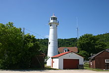
The light in 2004 from the lake side 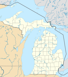

Location Munising, Michigan Coordinates 46°24′54″N 86°39′40″W / 46.41512°N 86.66115°WCoordinates: 46°24′54″N 86°39′40″W / 46.41512°N 86.66115°W Year first constructed 1908 Year first lit 1908 Construction Steel Tower shape Conical Markings / pattern White Height 24 feet (7.3 m) Focal height 79 feet (24 m) Characteristic F R ARLHS number USA-948 USCG number 7-14575[1] The Munising Front Range Light and its matching Munising Rear Range Light replaced the ineffective Grand Island East Channel Light in 1905. These two lights combine to guide boats from the open waters of Lake Superior down the East Channel next to Grand Island into the harbor of Munising. The history of these lighthouses is documented by Terry Pepper[2] and is not reproduced here.
The Front Range Light is located at the western edge of Munising north of M-28[3]). At this time, the light is managed by the National Parks Service, the grounds are open to visitors, but the tower is closed.
According to US Government publication, "The American Practical Navigator", Chapter 5: Range lights are light pairs that indicate a specific line of position when they are in line. The higher rear light is placed behind the front light. When the mariner sees the lights vertically in line, he is on the range line. If the front light appears left of the rear light, the observer is to the right of the range line; if the front appears to the right of the rear, the observer is left of the range line.[1]
References
External links
- "Historic Light Station Information and Photography: Michigan". United States Coast Guard Historian's Office. http://www.uscg.mil/history/weblighthouses/LHMI.asp.
- Lighthouse Central, Munising Front Range Light, The Ultimate Guide to Upper Michigan Lighthouses by Jerry Roach.. (Publisher: Bugs Publishing LLC - 2007). ISBN 978-0-9747977-2-4.
- Rowlett, Russ. "Lighthouses of the United States: Michigan's Eastern Upper Peninsula". The Lighthouse Directory. University of North Carolina at Chapel Hill. http://www.unc.edu/~rowlett/lighthouse/miup.htm.
Lighthouses of Michigan See also: List of lighthouses in MichiganNorthern upper peninsula Au Sable Light • Big Bay Point Light • Copper Harbor Light • Copper Harbor Front Range Light • Crisp Point Light • Eagle Harbor Light • Eagle Harbor Range Lights • Eagle River Light • Fourteen Mile Point Light • Grand Island East Channel Light • Grand Island Harbor Rear Range Light • Grand Island North Light • Granite Island Light • Gull Rock Light Station • Huron Island Light • Isle Royale Light • Manitou Island Light Station • Marquette Harbor Light • Mendota (Bete Grise) Light • Munising Front Range Light • Munising Rear Range Light • Portage River (Jacobsville) Light • Passage Island Light • Rock Harbor Light • Rock of Ages Light • Sand Hills Light • St. Martin Island Light • Stannard Rock Light • Thunder Bay Island Light • Whitefish Point LightSouthern upper peninsula DeTour Reef Light • Manistique East Breakwater Light • Martin Reef Light • Menominee Pier Light • Naubinway Island Light • Peninsula Point Light • Poverty Island Light • Sand Point Light Escanaba • Sand Point Light Baraga • Seul Choix Light • Squaw Island Light • White Shoal LightSt. Mary's River Frying Pan Island Light • Pipe Island Light • Point Iroquois Light • Round Island Light (St. Mary's River) • Six Mile Point Range Rear LightPortage River/Ship Canal Keweenaw Waterway (Portage Lake) Lower Entrance • Keweenaw Waterway Upper Entrance Light • Rouleau Point Range Front and Rear LightsStraits of Mackinac Bois Blanc Light • McGulpin Point Light • Old Mackinac Point Light • Round Island Light • Round Island Passage • St. Helena Island LightWestern lower peninsula Beaver Island Harbor Light • Beaver Island Head Light • Big Sable Point Light • Charlevoix Light • Charlevoix South Pier Light • Frankfort Light • Frankfort South Range Light • Grand Haven Light • Grand Haven South Pierhead Outer Light • Grand Haven Main Light • Gray's Reef Light • Holland Harbor Light • Ile Aux Galets • Little Sable Point Light • Little Traverse Light • Ludington Light • Manistee Main Light • Manistee Pierhead lights • Miller Memorial Light • Mission Point Light • Mission Point Light (2) • Muskegon Breakwater Light • Muskegon Pier Light • Point Betsie Light • South Fox Island • South Haven Light • South Manitou Island Light • Waugoshance Light • White River LightEastern lower peninsula Alpena Light • Bellanger Park (Ecorse) Light • Caseville Harbor (Saginaw Bay) • Belle Isle Light • Charity Island Light • Cheboygan River Range Front Light • Cheboygan Crib Light • Detroit River Light • Fort Gratiot Light • Forty Mile Point Light • Fourteen Foot Shoal Light • Gibraltar Light • Gravelly Shoal Light • Harbor Beach Light • Manning Memorial Light • Mariners Memorial (River Rouge) Light • New Presque Isle Light • Old Presque Isle Light • Poe Reef Light • Pointe aux Barques Light • Port Austin Light • Port Sanilac Light • Saginaw River Range Front Light • Saginaw River Rear Range Light • Spectacle Reef Light • St. Clair Flats Front and Rear Range Light • Sturgeon Point Light • Tawas Point Light • Tri-Centennial Light of Detroit • William Livingtone Memorial LightHistorical (lost) lights Au Sable North Pierhead • Clinton River Light • Ecorse Light • Ecorse Range Rear • Gibraltar Light • Grassy Island Lighthouse • Grassy Island North Channel Range • Grassy Island South Channel Range • Grosse Isle South Channel Range • Harwood Point East Range Front (St. Mary's River) • Mama Juda Light • Mama Juda Range Front • Middle Lake George • Monroe Pier • New Buffalo • North Manitou Island • Rouleau Point Range Front and Rear • Saginaw Bay • Sand Beach North Entrance East • Squaw Point • St. Mary's River Lower Range Front • Turtle Island Light • Vidal Shoals Channel Range Front and Rear • Windmill Point Range Front and Rear • Winter Point Range FrontRelated – Lightship Huron, List of lifesaving stations in MichiganCategories:- Lighthouses in Michigan
- 1905 architecture
- Buildings and structures completed in 1905
- Buildings and structures in Alger County, Michigan
- Transportation in Alger County, Michigan


Wikimedia Foundation. 2010.