- Manistee Pierhead lights
-
Manistee Pierhead lights 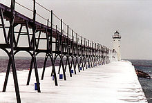
Manistee Breakwater Lighthouse Location Manistee, Michigan Coordinates 44°15′06″N 86°20′47″W / 44.2517°N 86.3464°WCoordinates: 44°15′06″N 86°20′47″W / 44.2517°N 86.3464°W Year first lit 1875 Automated 1927 Foundation pier Construction Cast Iron Tower shape cylindrical Markings / pattern white with black lantern Height Tower - 39 feet (12 m) Focal height Focal plane - 55 feet (17 m) Original lens fifth order Fresnel Lens Current lens 300 mm Tideland Signal Acrylic Optic Intensity 5000 candlepower Range 15 miles (24 km) Characteristic group occulting white light over 30 seconds Fog signal HORN: 1 blast every 15s (2s bl). Operates from Apr. 1 to Nov. 1.[1]
ARLHS number USA-468 USCG number 7-18450 Manistee North PierNRHP Reference#: 90000718 The Manistee Pierhead lights are a pair of active aids to navigation located on the north and south pier in the harbor of Manistee, Michigan, "Lake Michigan’s Victorian Port City."[2]
Contents
History
The first light was on the south pier in 1870. Unfortunately, it burnt in the Great fire of 1871, October 8, 1871, along with the town of Manistee.[3][4] Coincidentally, Manistee burnt on on the same day as the Great Chicago Fire, Peshtigo Fire in Wisconsin, and fires in Port Huron and Holland, Michigan.[5]
Two lighthouses were built, one on each pier in 1875. Over the years the lights have been moved several times, including moves to and from the mainland, and to and from the south to the north pier. Lights have been torn down and rebuilt.
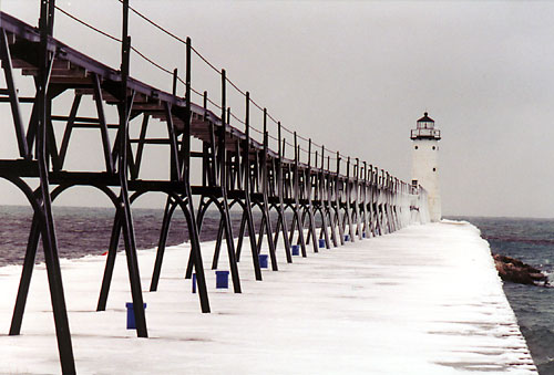
The current tower is located on the north pier. It is constructed of cast iron, and was first listed in 1927. The tower is a white cylinder, and the keepers house is separate. The original lens was a Fifth Order Fresnel lens.[6] The tower has also been rebuilt as the pier has been extended. Other changes have involved the placement and configuration of the fog horn.[2] The present tower is 39 feet (12 m) tall. The catwalk is one of only four that survive in the State of Michigan.[7] National Register of Historic Places, Reference # 90000718 The tower is capped with a ten-sided steel lantern. The light uses a 5,000 candlepower incandescent electric bulb, and has a flashing mechanism which displays "a group occulting white light" over 30 seconds. Its focal plane is 55 feet (17 m), and is visible for 15 miles (24 km) in clear weather. The "Type C" diaphone is powered by an electric compressor housed in the tower, and emits a group of three blasts every 30 seconds.[2] There is also a radio beacon.[8]
The northern pier light is located on the same side of the river as the Manistee Coast Guard station, and within shouting distance of the Manistee South pier light.[4]
The south pier has a 37-foot (11 m) steel tower navigational aid. This was constructed when the lighthouse was moved to the north pier in 1927.[2]
Manistee Pierhead Light was put up for sale under the National Historic Lighthouse Preservation Act in 2009.[9]
Directions
From
 US 31 go 1.5 miles (2.4 km) west on Memorial Drive, to the Fifth Ave. Beach and Park.
See also
Notes
- ^ (PDF) Light List, Volume VII, Great Lakes. Light List. United States Coast Guard. http://www.navcen.uscg.gov/pdf/lightLists/LightList%20V7.pdf.
- ^ a b c d Terry Pepper, Seeing the Light, Manistee Pierhead Lighthouse.
- ^ Lighthouses of Michigan, Manistee Pierhead lights.
- ^ a b Boatnerd, Manistee Light.
- ^ The Great Fire Of 1871
- ^ "Historic Light Station Information and Photography: Michigan". United States Coast Guard Historian's Office. http://www.uscg.mil/history/weblighthouses/LHMI.asp.
- ^ National Park Service, National Maritime Heritage Program, Inventory of Historic Lights, Manistee North Pier.
- ^ Manistee Pierhead Lighthouse Page from Michigan Lighthouse Conservancy.
- ^ "NHLPA 2009 Program, Notices of Availability". www.nps.gov. http://www.nps.gov/history/maritime/nhlpa/noas2009.htm. Retrieved June 6, 2009.
Further reading
- Bibliography on Michigan lighthouses.
- Crompton, Samuel Willard & Michael J. Rhein, The Ultimate Book of Lighthouses (2002) ISBN 1592231020; ISBN 978-1592231027.
- Hyde, Charles K., and Ann and John Mahan. The Northern Lights: Lighthouses of the Upper Great Lakes. Detroit: Wayne State University Press, 1995. ISBN 0814325548 ISBN 9780814325544.
- Jones, Ray & Bruce Roberts, American Lighthouses (Globe Pequot, September 1, 1998, 1st Ed.) ISBN 0762703245; ISBN 978-0762703241.
- Jones, Ray,The Lighthouse Encyclopedia, The Definitive Reference (Globe Pequot, January 1, 2004, 1st ed.) ISBN 0762727357; ISBN 978-0762727353.
- Lynn, Bruce. "A Light is on in the Graveyard [Whitefish Point]." Lighthouse Digest (Aug 1997), pp. 1–3.
- Noble, Dennis, Lighthouses & Keepers: U. S. Lighthouse Service and Its Legacy (Annapolis: U. S. Naval Institute Press, 1997). ISBN 1557506388; ISBN 9781557506382.
- Oleszewski, Wes, Great Lakes Lighthouses, American and Canadian: A Comprehensive Directory/Guide to Great Lakes Lighthouses, (Gwinn, Michigan: Avery Color Studios, Inc., 1998) ISBN 0-932212-98-0.
- Penrod, John, Lighthouses of Michigan, (Berrien Center, Michigan: Penrod/Hiawatha, 1998) ISBN 9780942618785 ISBN 9781893624238.
- Pepper, Terry. "Seeing the Light: Lighthouses on the western Great Lakes". http://www.terrypepper.com/lights/index.htm.
- Putnam, George R., Lighthouses and Lightships of the United States, (Boston: Houghton Mifflin Co., 1933).
- United States Coast Guard, Aids to Navigation, (Washington, DC: U. S. Government Printing Office, 1945).
- Scott T. Price. "U. S. Coast Guard Aids to Navigation: A Historical Bibliography". United States Coast Guard Historian's Office. http://www.uscg.mil/History/weblighthouses/h_lhbib.asp.
- Wagner, John L.. "Beacons Shining in the Night: The Lighthouses of Michigan". Clarke Historical Library, Central Michigan University. http://clarke.cmich.edu/lighthouses/index.htm.
- Wagner, John L., Michigan Lighthouses: An Aerial Photographic Perspective, (East Lansing, Michigan: John L. Wagner, 1998) ISBN 1880311011 ISBN 9781880311011.
- Wright, Larry and Wright, Patricia, Great Lakes Lighthouses Encyclopedia Hardback (Erin: Boston Mills Press, 2006) ISBN 1550463993.
External links
- Aerial photos, Manistee North Pierhead Light, marinas.com.
- Detroit News, Interactive map on Michigan lighthouses.
- Interactive map of Lights in Northern Lake Michigan, mapped by Google.
- Lighthouse Central, Photographs, History, Directions and Way points for Manistee North Pierhead Light, The Ultimate Guide to West Michigan Lighthouses by Jerry Roach (Publisher: Bugs Publishing LLC - 2005). ISBN 0-9747977-0-7.
- Rowlett, Russ. "Lighthouses of the United States: Michigan's Western Lower Peninsula". The Lighthouse Directory. University of North Carolina at Chapel Hill. http://www.unc.edu/~rowlett/lighthouse/miwl.htm.
- Lighthousefriends.com Manistee North Pierhead Light
- Manistee Pierhead Lighthouse Page from Michigan Lighthouse Conservancy.
- Lighthouses of Michigan, Manistee Pierhead lights.
- Map of lighthouses in northern Lake Michigan.
- Map of Michigan Lighthouse in PDF Format.
- Michigan Lighthouse Conservancy, Manistee North Pierhead light.
- National Park Service, National Maritime Heritage Program, Inventory of Historic Lights, Manistee North Pier.
- Terry Pepper, Seeing the Light, Manistee Pierhead Lighthouse.
- "Historic Light Station Information and Photography: Michigan". United States Coast Guard Historian's Office. http://www.uscg.mil/history/weblighthouses/LHMI.asp.
- Wobser, David, Manistee North Pierhead Light, Boatnerd.com.
Lighthouses of Michigan See also: List of lighthouses in Michigan Northern upper peninsula Au Sable Light • Big Bay Point Light • Copper Harbor Light • Copper Harbor Front Range Light • Crisp Point Light • Eagle Harbor Light • Eagle Harbor Range Lights • Eagle River Light • Fourteen Mile Point Light • Grand Island East Channel Light • Grand Island Harbor Rear Range Light • Grand Island North Light • Granite Island Light • Gull Rock Light Station • Huron Island Light • Isle Royale Light • Manitou Island Light Station • Marquette Harbor Light • Mendota (Bete Grise) Light • Munising Front Range Light • Munising Rear Range Light • Portage River (Jacobsville) Light • Passage Island Light • Rock Harbor Light • Rock of Ages Light • Sand Hills Light • St. Martin Island Light • Stannard Rock Light • Thunder Bay Island Light • Whitefish Point LightSouthern upper peninsula DeTour Reef Light • Manistique East Breakwater Light • Martin Reef Light • Menominee Pier Light • Naubinway Island Light • Peninsula Point Light • Poverty Island Light • Sand Point Light Escanaba • Sand Point Light Baraga • Seul Choix Light • Squaw Island Light • White Shoal LightSt. Mary's River Frying Pan Island Light • Pipe Island Light • Point Iroquois Light • Round Island Light (St. Mary's River) • Six Mile Point Range Rear LightPortage River/Ship Canal Keweenaw Waterway (Portage Lake) Lower Entrance • Keweenaw Waterway Upper Entrance Light • Rouleau Point Range Front and Rear LightsStraits of Mackinac Bois Blanc Light • McGulpin Point Light • Old Mackinac Point Light • Round Island Light • Round Island Passage • St. Helena Island LightWestern lower peninsula Beaver Island Harbor Light • Beaver Island Head Light • Big Sable Point Light • Charlevoix Light • Charlevoix South Pier Light • Frankfort Light • Frankfort South Range Light • Grand Haven Light • Grand Haven South Pierhead Outer Light • Grand Haven Main Light • Gray's Reef Light • Holland Harbor Light • Ile Aux Galets • Little Sable Point Light • Little Traverse Light • Ludington Light • Manistee Main Light • Manistee Pierhead lights • Miller Memorial Light • Mission Point Light • Mission Point Light (2) • Muskegon Breakwater Light • Muskegon Pier Light • Point Betsie Light • South Fox Island • South Haven Light • South Manitou Island Light • Waugoshance Light • White River LightEastern lower peninsula Alpena Light • Bellanger Park (Ecorse) Light • Caseville Harbor (Saginaw Bay) • Belle Isle Light • Charity Island Light • Cheboygan River Range Front Light • Cheboygan Crib Light • Detroit River Light • Fort Gratiot Light • Forty Mile Point Light • Fourteen Foot Shoal Light • Gibraltar Light • Gravelly Shoal Light • Harbor Beach Light • Manning Memorial Light • Mariners Memorial (River Rouge) Light • New Presque Isle Light • Old Presque Isle Light • Poe Reef Light • Pointe aux Barques Light • Port Austin Light • Port Sanilac Light • Saginaw River Range Front Light • Saginaw River Rear Range Light • Spectacle Reef Light • St. Clair Flats Front and Rear Range Light • Sturgeon Point Light • Tawas Point Light • Tri-Centennial Light of Detroit • William Livingtone Memorial LightHistorical (lost) lights Au Sable North Pierhead • Clinton River Light • Ecorse Light • Ecorse Range Rear • Gibraltar Light • Grassy Island Lighthouse • Grassy Island North Channel Range • Grassy Island South Channel Range • Grosse Isle South Channel Range • Harwood Point East Range Front (St. Mary's River) • Mama Juda Light • Mama Juda Range Front • Middle Lake George • Monroe Pier • New Buffalo • North Manitou Island • Rouleau Point Range Front and Rear • Saginaw Bay • Sand Beach North Entrance East • Squaw Point • St. Mary's River Lower Range Front • Turtle Island Light • Vidal Shoals Channel Range Front and Rear • Windmill Point Range Front and Rear • Winter Point Range FrontRelated – Lightship Huron, List of lifesaving stations in Michigan U.S. National Register of Historic Places Topics Lists by states Alabama • Alaska • Arizona • Arkansas • California • Colorado • Connecticut • Delaware • Florida • Georgia • Hawaii • Idaho • Illinois • Indiana • Iowa • Kansas • Kentucky • Louisiana • Maine • Maryland • Massachusetts • Michigan • Minnesota • Mississippi • Missouri • Montana • Nebraska • Nevada • New Hampshire • New Jersey • New Mexico • New York • North Carolina • North Dakota • Ohio • Oklahoma • Oregon • Pennsylvania • Rhode Island • South Carolina • South Dakota • Tennessee • Texas • Utah • Vermont • Virginia • Washington • West Virginia • Wisconsin • WyomingLists by territories Lists by associated states Other  Category:National Register of Historic Places •
  Portal:National Register of Historic PlacesCategories:
- Lighthouses in Michigan
- Buildings and structures in Manistee County, Michigan
- National Register of Historic Places in Michigan
- Lighthouses on the National Register of Historic Places
- Visitor attractions in Manistee County, Michigan
- Transportation in Manistee County, Michigan
Wikimedia Foundation. 2010.