- Pointe aux Barques Light
Infobox_Lighthouse
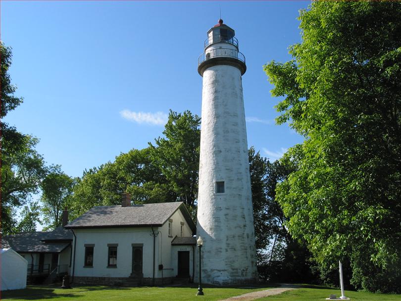
caption = Pointe Aux Barques Light
location =Port Hope, Michigan
coordinates = coord|44|01|24|N|82|47|36|W|
established = 1848
yearbuilt = 1848
yearlit = 1857
automated = 1958
yeardeactivated =
construction = Brick
foundation = Dressed stone and timber
shape = Conical
marking = White with black and red trim
height = Tower - convert|89|ft|m
elevation = Focal plane - convert|93|ft|m
lens = Third orderFresnel lens with bullseyes
currentlens = DCB 224 Aerobeacon
range = convert|28|mi|km
characteristic = 20 sec./ .2" fl., 4.8" ec.; .2" fl. 14.8" ec. [ [http://www.navcen.uscg.gov/pubs/LightLists/V7COMPLETE.PDF Volume 7, US Coast Guard Lightlist (PDF).] ]
intensity =
admiralty =
owner = Huron County Parks
NGA =
ARLHS = USA-615
USCG = 7-10210
National Register = 73000949The Pointe aux Barques Lighthouse ranks among the ten oldest lighthouses in Michigan. It is an active
lighthouse maintained by the US Coast Guard remotely, located in Lighthouse County Park onLake Huron nearPort Hope, Michigan in Huron County. "Pointe aux Barques" means 'Point of Little Boats', a descriptor of the shallowshoal s andreef s that lurk beneath these waves, presenting a hazard to boats as they round Michigan's Thumb. [ [http://www.detnews.com/apps/pbcs.dll/article?AID=/20080520/SPECIAL01/80519001 Detroit News Pointe aux Barques.] ]History
In the mid-1800s most travel was by sailing vessel. There were few or no roads, and only a few steamships were operating on the
Great Lakes . Navigation was still primitive by today’s standards. Vessels followed the coastline of the lakes until there was a need to cross a large body of water, and then a compass and sextant were the major navigation tools.Sailing schooners left
Detroit and theSt. Clair River and soon left the sight of the 1825Fort Gratiot Light and began the perilous trip north along theLake Huron shore. The next light to the north was located atThunder Bay Island (1832), more than convert|150|mi|km north ofFort Gratiot . Any vessel sailing up theLake Huron coast stood a good chance of going aground on the reef extending out from Pointe aux Barques. The reef is only covered by some two feet of water and stuck out nearly two miles into Lake Huron.Pointe aux Barques was also used as a turning point for vessels destined to the
Saginaw River . Range lights had been established at the mouth of theSaginaw River as early as 1841, but the trip toSaginaw Bay required steering clear of Pointe aux Barques reef.The lighthouse was intended to be constructed near the Thumb's most northwestern point at Pointe Aux Barques however it was ultimately constructed approximately 4.5 miles east / southeast in what is now Huron Township.
President James K. Polk appropriated $5,000 to build the first lighthouse structure on July 3, 1847. The first keeper, Peter Shook and his family, moved in in 1848. In 1849 the keeper's dwelling burned to the ground. The first light tower was built on this location in 1847, at a cost of $5,000. It was first lit for the 1848 shipping season. The tower was poorly constructed and needed to be replaced after only 10 years.
The present 1857 light is a conical white brick tower, convert|89|ft|m tall, with a focal plane of convert|93|ft|m above Lake Huron. A rotating Third Order
Fresnel lens provided a flash every two minutes visible as far convert|16|mi|km out on the lake. The tower is attached to a 2-story brick keeper’s dwelling by a matching brick passageway.The new taller light tower helped guide vessels away from the hazardous reef, but wrecks continued to occur. In 1875 a United States Life Saving Service station was built just south of the lighthouse.
An assistant keeper's house was added in 1908, and the light was upgraded to an incandescent vapor lamp in 1914. The change increased the lights range to convert|18|mi|km over the lake, and further protection was added in 1918 with the addition of a lighted bell buoy some two and a quarter miles off shore at the end of the point.
Electrification came to Point aux Barques in 1932 and the incandescent light bulb in the Third Order lens with bullseyes provided an output of 120,000 candlepower. The
Coast Guard assumed responsibility for the nation's aids to navigation in 1939, and the way was paved for complete automation. The signal was further improved around 1950 with the removal of theFresnel lens and the installation of rotating DCB-224 aero beacons rated at 1,000,000 candlepower. Putting aside questions of nostalgia, aesthetics, or appreciation for the engineering of a bygone era (as exemplified by the Fresnel lens), this iteration of lighthouse illumination is itself incredibly effective, and an endangered remnant of another bygone era. [ [http://www.stormheroes.com/aton/dcb36.htm Aerobeacon, Stormherocs.com.] ]Michigan Historical Marker
On Sunday, August 5, 2007, a Michigan Historical Marker was dedicated at the grounds of the lighthouse. Cindy Krueger, an employee of the Department of History, Arts, and Libraries (HAL) and the great-great-great-granddaughter of light keepers Peter and Catherine Shook, presented the marker.
The State Historic Preservation Office, which administers the Michigan Historical Marker Program, awarded a $31,000 Michigan Lighthouse Assistance Grant to the county for a historic structures report and plans and specifications for the restoration of the lighthouse. The Michigan Lighthouse Assistance Grant is funded through the sale of the "Save our Lights" specialty license plates. The county received an additional $70,000 CMI (Clean Michigan Initiative) grant from the Department of Environmental Quality for restoration. Since the Michigan Historical Marker Program began in 1955, the Michigan Historical Commission has placed more than 1,500 markers throughout the state. The markers are paid for with donations from sponsors who submit application packages to the State Historic Preservation Office. The Michigan Historical Commission determines the placement and wording of official state markers, which are the property of the State of Michigan. The Pointe Aux Barques Lighthouse Society donated the $2,875 for the marker.
The text on the Historical Marker reads as follows:
Point aux Barques Lighthouse
The Point aux Barques Lighthouse and Lifesaving Station aided mariners for over a century, beginning in 1847. That year the U.S. Lighthouse Service built the first lighthouse on this site to mark the turning point of Lake Huron into Saginaw Bay and to warn of shallow waters. Catherine Shook became Michigan’s first female light keeper when she took over for her husband, Peter, after he drowned in 1849. In 1857, the lighthouse and dwelling with the present 89 foot tower and attached house. In 1908, the brick assistant keeper’s house was built. The lighthouse was fully automated in 1934. Five years later, the last keeper retired, and the lifesaving station, made up of 15 building, was decommissioned.
Pointe aux Barques today
The 1857 tower and attached keepers dwelling remain intact, along with the 1908 assistant keeper’s dwelling and a round iron oil house. The keeper’s dwelling is home to a museum. One room contains memorabilia of the lighthouse, its history, and keepers. Many original documents and pictures are on display. Another room interprets the many ship wrecks that lie under the local waters.
Following automation, the lighthouse grounds were turned over to Huron County and transfer was completed in June, 2003. The tower is an active aid to navigation and is not open to the public. A camp ground was established near the light station in the area where an 1876 United States Life Saving Service (USLSS) station had been located.
A group of students from
Western Michigan University performed anarcheological dig at the site in 2003. They unearthed evidence of a 1840s lighthouse structure that preceded the 1857 building. It was also reapired extensively in 2005. [ [http://www.lighthousedepot.com/lite_digest.asp?action=get_article&sk=2334&bhcd2=1216384497 Lighthouse Digest, Point aux Barques Light repaired, November, 2005.] ]In 1972, the lighthouse was listed in the
National Register of Historic Places , Reference #73000949. [ [http://www.michiganlights.com/pointauxbarqueslh.htm Michigan Lighthouse Conservancy] ] On site are two museums,namely - "THE KEEPERS OF THE LIGHT" and "THE THUMB UNDERWATER PRESERVE". [ [http://www.michiganlighthouse.org/lighthouse_detail.php77.htm Michigan Lighthouse project, Pointe aux Barques Light.] ] The original Third OrderFresnel lens , from Pointe aux Barques, is on display at the museum in Huron City.The Pointe aux Barques Lighthouse Society (PaBLS), founded in 2002, is dedicated to preserving and restoring the light station and museum located inside. [ [http://www.michigan.org/Property/Detail.aspx?p=G5532 Pointe Aux Barques Lighthouse and Museum] ]
Location
Located off on Lighthouse Road. It is a Huron County park. A campground is located adjacent to the base of the light. Visitors can easily spend the better part of a day touring the lighthouse grounds and museum or just enjoying the beauty of the Lake Huron shore. [ [http://www.pointeauxbarqueslighthouse.org Pointe aux Barques Lighthouse Society.] ]
External links
* [http://www.detnews.com/apps/pbcs.dll/article?AID=/20080520/SPECIAL01/80519001 Detroit News, Interactive map on Michigan lighthouses.]
* [http://www.lighthousesrus.org/Maps/GL/HuronW.htm Interactive map of Lighthouses in the area.]
* [http://www.lighthousesrus.org/HuronW.htm Interactive map, list, information for lighthouses in North and West Lake Huron.]
* [http://www.lighthousecentral.com/lighthouse_gallery.php4?lighthouse=Pointe%20Aux%20Barques%20Lighthouse Lighthouse Central, Point Aux Barques Lighthouse Photographs, History and Directions, "The Ultimate Guide to East Michigan Lighthouses" by Jerry Roach] (Publisher: Bugs Publishing LLC - July 2006).] ISBN 0974797715; ISBN 9780974797717.
* [http://www.unc.edu/~rowlett/lighthouse/miel.htm Lighthouse Digest, Point Aux Barques Light, University of North Carolina.]
*National Park Service , [http://www.nps.gov/history/maritime/light/ptauxbar.htm Maritime Heritage Project, Inventory of Lights, Pointe aux Barques Light.]
* [http://www.michigan.gov/documents/hal_mhc_shpo_lightmap_50933_7.pdf Map of Michigan Lighthouses] .
* [http://www.michiganlights.com/pointauxbarqueslh.htm Michigan Lighthouse Conservancy]
* [http://www.michiganlighthouse.org/lighthouse_detail.php77.htm Michigan Lighthouse project, Pointe aux Barques Light.]
* [http://www.michigan.org/Property/Detail.aspx?p=G5532 Pointe Aux Barques Lighthouse and Museum]
* [http://www.pointeauxbarqueslighthouse.org/ Pointe Aux Barques Lighthouse Society]
* [http://www.terrypepper.com/Lights/huron/ptauxbarques/index.htm Terry Pepper, Seeing the Light, Pointe aux Barques Light]
*U.S. Coast Guard [http://www.uscg.mil/history/weblighthouses/LHMI.asp 's complete list of Michigan lights with photographs and descriptions, including Point aux Barques light.]
* [http://www.navcen.uscg.gov/pubs/LightLists/V7COMPLETE.PDF Volume 7, US Coast Guard Lightlist (PDF).]
* [http://lighthouse.boatnerd.com/gallery/Huron/pointauxbarques.htm Wobser, David, Two Museums in One Place: Point aux Barques Light, Boatnerd.com.]Bibliography and further reading
* [http://www.michiganlighthouse.org/bibliography.html Bibliography on Michigan lighthouses.]
* Crompton, Samuel Willard & Michael J. Rhein, "The Ultimate Book of Lighthouses" (2002) ISBN 1592231020; ISBN 978-1592231027.
* Hyde, Charles K., and Ann and John Mahan. "The Northern Lights: Lighthouses of the Upper Great Lakes." Detroit: Wayne State University Press, 1995. ISBN 0814325548 ISBN 9780814325544.
* Jones, Ray & Bruce Roberts, "American Lighthouses" (Globe Pequot, September 1, 1998, 1st Ed.) ISBN 0762703245; ISBN 978-0762703241.
* Jones, Ray,"The Lighthouse Encyclopedia, The Definitive Reference" (Globe Pequot, January 1, 2004, 1st ed.) ISBN 0762727357; ISBN 978-0762727353.
* Noble, Dennis, "Lighthouses & Keepers: U. S. Lighthouse Service and Its Legacy" (Annapolis: U. S. Naval Institute Press, 1997). ISBN 1557506388; ISBN 9781557506382.
* Oleszewski, Wes, "Great Lakes Lighthouses, American and Canadian: A Comprehensive Directory/Guide to Great Lakes Lighthouses", (Gwinn, Michigan: Avery Color Studios, Inc., 1998) ISBN 0-932212-98-0.
* Penrod, John, "Lighthouses of Michigan", (Berrien Center, Michigan: Penrod/Hiawatha, 1998) ISBN 9780942618785 ISBN 9781893624238.
*
* Putnam, George R., "Lighthouses and Lightships of the United States", (Boston: Houghton Mifflin Co., 1933).
* United States Coast Guard, "Aids to Navigation", (Washington, DC: U. S. Government Printing Office, 1945).
* [http://www.uscg.mil/History/weblighthouses/h_lhbib.asp United States Coast Guard, "Aids to Navigation Historical Bibliography".]
*
* Wagner, John L., "Michigan Lighthouses: An Aerial Photographic Perspective", (East Lansing, Michigan: John L. Wagner, 1998) ISBN 1880311011 ISBN 9781880311011.
* Wargin, Ed, "Legends of Light: A Michigan Lighthouse Portfolio" (Ann Arbor Media Group, 2006). ISBN 9781587262517.
* Wright, Larry and Wright, Patricia, "Great Lakes Lighthouses Encyclopedia" Hardback (Erin: Boston Mills Press, 2006) ISBN 1550463993References
ee also
*
Great Lakes Storm of 1913
*Lighthouses in the United States .
* [http://www.michmarkers.com/default.asp The Michigan Historical Marker Web Site ]
* [http://michigan.gov/som/0,1607,7-192-26847-173379--,00.html Port Hope's Pointe aux Barques Lighthouse to Receive Michigan Historical Marker Aug. 5 ]*
Shipwrecks of the 1913 Great Lakes storm .
Wikimedia Foundation. 2010.