- Cockett (electoral ward)
-
Cockett Ward 
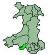
Ordnance Survey OS grid reference: Maps for SS6395 Geography Principal locality Cockett Total population 12,586 (2001 census) Land area (km²) 8.59 (2001 census) Administration Local council: City and County of Swansea Number of councillors: 4 Nation: Wales Post office and telephone Postcode(s): SA2 Dialling code: +44-1792 Politics Welsh Assembly: Swansea West UK Parliament: Swansea West European Parliament: Wales Cockett (Welsh: Coced) is the name of an electoral ward and a community in the City and County of Swansea, Wales, UK. The community does not have a community council.
The electoral ward consists of some or all of the following areas: Cadle, Cwmdu, Coedweig, Gendros, Gors, Fforestfach, Cockett and Waunarlwydd, in the parliamentary constituency of Swansea West. The community does not have its own community council. The ward is bounded by the wards of Kingsbridge and Penderry to the north; Cwmbwrla to the east; Townhill to the south east; Sketty and Killay North to the south; and Gowerton to the west.
Contents
2008 local council elections
The turnout for Cockett in the 2008 local council elections was 33.52%. It was a close set of results and after a recount, it was a clean sweep for the Liberal Democrats. The results were:
Candidate Party Votes Status William Keith Morgan Liberal Democrats 1102 Liberal Democrats gain Nicola Anne Holley Liberal Democrats 1047 Liberal Democrats gain James Bernard Kelleher Liberal Democrats 996 Liberal Democrats gain Veronyca Anne Bates Hughes Liberal Democrats 993 Liberal Democrats gain Anna Mary Pennock Labour 985 Andrew John Jones Labour 946 Susan Grace Lewis Labour 932 John Rhodri Thomas Plaid Cymru 879 John Abraham Labour 878 Adrian Hugh Rees Plaid Cymru 870 Enid Vanessa Webb Plaid Cymru 866 Jonathan Clive Howes Plaid Cymru 835 Lisa Emma Gilmore Conservatives 363 David William Turner Conservatives 360 Craig James Robert Lawton Conservatives 348 William Mathew Ogborne Conservatives 345 Districts of Cockett
Cockett
The suburb of Cockett is a residential area in the ward.
Fforest-fach
The suburb of Fforestfach lies immediately north of the suburb of Cockett.
Waunarlwydd
The suburb of Waunarlwydd adjoins Fforestfach and Cockett to the West.
Categories:- Swansea electoral wards
- Communities of Swansea
Wikimedia Foundation. 2010.

