- Distress radiobeacon
-
"PLB" redirects here. For other uses, see PLB (disambiguation).
 Emergency position-indicating radio beacons or EPIRBs
Distress radio beacons, also known as emergency beacons, ELT or EPIRB, are tracking transmitters which aid in the detection and location of boats, aircraft, and people in distress. Strictly, they are radiobeacons that interface with worldwide offered service of Cospas-Sarsat, the international satellite system for search and rescue (SAR). When manually activated, or automatically activated upon immersion, such beacons send out a distress signal. The signals are monitored worldwide and the location of the distress is detected by non-geostationary satellites, and can be located by trilateration in combination with triangulation, respecting the varying quality of the signal received.[1]
In the case of 406 MHz beacons which transmit digital signals, the beacons can be uniquely identified almost instantly (via GEOSAR), and furthermore a GPS or GLONASS position can be encoded into the signal, which provides instantaneous identification of the registered user and its location. Frequently, by using the initial position provided via the satellite system, SAR aircraft and ground search parties can home in on the distress signals from the beacons and come to the aid of the concerned boat, aircraft, or people.
There are three types of distress radio beacons compatible with the Cospas-Sarsat system:[2]
- EPIRBs (emergency position-indicating radio beacons) signal maritime distress.
- ELTs (emergency locator transmitters) signal aircraft distress.
- PLBs (personal locator beacons) are for personal use and are intended to indicate a person in distress who is away from normal emergency services; e.g., 9-1-1. They are also used for crewsaving applications in shipping and lifeboats at terrestrial systems. In New South Wales, some police stations and the National Parks and Wildlife Service, provide personal locator beacons to hikers for no charge.[3]
The basic purpose of distress radiobeacons is to get people rescued within the so-called "golden day"[4] (the first 24 hours following a traumatic event) during which the majority of survivors can usually be saved.
Since the inception of Cospas-Sarsat in 1982, distress radiobeacons have assisted in the rescue of over 28,000 people in more than 7,000 distress situations.[5] In 2009 only, the System provided information which was used to rescue 1,596 persons in 478 distress situations.[5]
General description
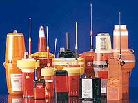
Most beacons are brightly colored and waterproof. EPIRBs and ELTs are larger, and would fit in a cube about 30 cm (12 in) on a side, and weigh 2 to 5 kg (4 to 11 lb). PLBs vary in size from cigarette-packet to paperback book and weigh 200 g to 1 kg (½ to 2½ lb). They can be purchased from marine suppliers, aircraft refitters, and (in Australia and the United States) hiking supply stores. The units have a useful life of 10 years, operate across a range of conditions (−40°C/°F to +40°C/+104°F), and transmit for 24 to 48 hours.[6] As of 2003 the cost ranges from around US$139 to US$3000. The performance and specifications of radiobeacons varies according to cost, as described later in this article.
Classification nomenclature
The three distress radiobeacon types are further classified as follows:[2]
Beacon modes
The most important aspect of a beacon in classification is the mode of transmission. There are two valid transmission modes: digital and analog. Where digital usually has a longer range, analog is more reliable.
Digital mode: 406 MHz beacons
406 MHz beacons transmit bursts of digital distress information to orbiting satellites, and may also contain a small integrated analog (121.5 MHz) homing beacon. Advanced 406 MHz beacons are capable of transmitting a highly-accurate GPS location within their distress message, thus, the process of distress relief is reduced from "search and rescue" to "get to and rescue". Getting to the location nonetheless may be very difficult.
The distress message transmitted by a 406 beacon contains the information such as:
- which country the beacon originates from
- a unique 15-digit hexadecimal beacon identification code (a "15-hex ID")
- the encoded identification of the vessel or aircraft in distress, either as an MMSI value, or as, in the case of an ELT, either the aircraft's registration or its ICAO 24-bit address (from its Mode-S transponder)
- when equipped, a GPS position
- whether or not the beacon contains a 121.5 MHz "homer"
The digital distress message generated by the beacon varies according to the above factors and is encoded in 30 hexadecimal characters. The unique 15-character digital identity (the 15-hex ID) is hard-coded in the firmware of the beacon.
406 MHz beacon facts
- 406 MHz beacons transmit for a quarter of a second immediately when turned on, and then transmit a digital burst once every 50 seconds thereafter. Both GEOSAR and LEOSAR satellites monitor these signals.
- 406 MHz beacons will be the only beacons compatible with the MEOSAR (DASS) system.[7]
- 406 MHz beacons must be registered (see below).
Hex codes
Example hex codes look like the following: 90127B92922BC022FF103504422535 [8]
- A bit telling whether the message is short (15 hex digits) or long (30 hex digits) format.
- A country code, which lets the worldwide COSPAS/SARSAT central authority identify the national authority responsible for the beacon.
- Embedded 15-Hex ID or 15-hex transmitted distress message, for example, 2024F72524FFBFF The hex ID is printed or stamped on the outside of the beacon and is hard-coded into its firmware. The 15-hex ID can only be reprogrammed by certified distress radiobeacon technicians. The national authority uses this number to look up phone numbers and other contact information for the beacon. This is crucial to handle the large number of false alarms generated by beacons.
- A location protocol number, and type of location protocol: EPIRB or MMSI, as well as all the data fields of that location protocol. If the beacon is equipped with GPS or GLONASS, a rough (rounded) latitude and longitude giving the beacon's current position. In some aircraft beacons, this data is taken from the aircraft's navigation system.
- When a beacon is sold to another country, the purchaser is responsible for having the beacon reprogrammed with a new country code and to register it with his/her nation's beacon registry, and the seller is responsible to de-register the deprecated beacon ID with his/her national beacon registry.
- One can use the beacon decoder web page[9] at Cospas-Sarsat to decrypt/extract the 15-hex ID from the 30-hex distress message.
AIS SART
Main article: AIS-SARTThese devices are similar to traditional SAR radar transponders (SART), which additionally include a GPS receiver and a transmitter on VHF AIS channels, so they show up on ship AIS receivers. They are lightweight and can be used to equip inflatable liferafts.
Analog mode: all other beacons
- A simple analog siren tone is transmitted continuously until the battery dies.
- In the case of 121.5 MHz beacons, the frequency is monitored by most commercial airliners.
- The Cospas-Sarsat system detected this type of beacon—prior to 1 February 2009—when a LEOSAR satellite was in view of both the beacon and an LEOLUT (satellite dish). Satellite detection of 121.5 MHz beacons ceased on 1 February 2009 (see below).
Frequency
Distress beacons transmit distress signals on the following key frequencies; the frequency used distinguishes the capabilities of the beacon. A recognized beacon can operate on one of the three (currently) Cospas-Sarsat satellite-compatible frequencies. In the past, other frequencies were also used as a part of the search and rescue system.
Cospas-Sarsat (satellite) compatible beacon frequencies
- 406 MHz UHF- carrier wave at 406.025 MHz ± 0.005 MHz[2]
- 121.5 MHz VHF ± 6 kHz (frequency band protected to ±50 kHz)[10] (Satellite detection ceased on 1 February 2009, but this frequency is still used for short-range location during a search and rescue operation)
- 243.0 MHz VHF ± 12 kHz (frequency band protected to ± 100 kHz)[10][11] (prior to 1 February 2009)
Cospas-Sarsat incompatible beacon frequencies
- Marine VHF radio channels 15/16 - these channels are used only on the obsolete Class C EPIRBs
- The obsolete Inmarsat-E beacons transmitted to Inmarsat satellites on 1646 MHz UHF.
Types
The type of a beacon is determined by the environment for which it was designed to be used:
- EPIRBs (Emergency Position Indicating Radio Beacons) signal maritime distress,
- ELTs (Emergency Locator Transmitters) signal aircraft distress
- PLBs (Personal Locator Beacons) are for personal use and are intended to indicate a person in distress who is away from normal emergency services (i.e., 9-1-1)
Each type is sub-classified:
EPIRB sub-classification
EPIRBS are sub-classified as follows:[12]
Recognized categories:
- Category I - 406/121.5 MHz. Float-free, automatically activated EPIRB. Detectable by satellite anywhere in the world. Recognized by GMDSS.
- Category II - 406/121.5 MHz. Similar to Category I, except is manually activated. Some models are also water activated.
Unrecognized classes:
- Class A - 121.5/243 MHz. Float-free, automatically activating. These devices have been phased out by the U.S. Federal Communications Commission (FCC) and are no longer recognized.
- Class B - 121.5/243 MHz. Manually activated version of Class A. These devices have been phased out by the FCC and are no longer recognized.
- Class S - 121.5/243 MHz. Similar to Class B, except it floats, or is an integral part of a survival craft (lifeboat). These devices have been phased out by the FCC and are no longer recognized.
- Class C - Marine VHF ch15/16. Manually activated, these beacons operate on maritime channels only, and therefore are not detectable by satellite or normal aircraft. These devices have been phased out by the FCC and are no longer recognized.
- Inmarsat-E - This service ended 1 December 2006; all former users have switched to Category I or II 406 MHz EPIRBS. These beacons were float-free, automatically activated EPIRBs operated on 1646 MHz. They were detectable by Inmarsat geostationary satellites, and were recognized by GMDSS. See Inmarsat-E.
ELT sub-classification
ELTs for aircraft may be classed as follows:[13]
- A ELT, automatically ejected
- AD ELT, automatic deployable
- F ELT, Fixed
- AF ELT, automatic fixed
- AP ELT, automatic portable
- W ELT, water activated
- S ELT, survival
Within these classes, an ELT may be either a digital 406 MHz beacon, or an analog beacon (see above).
PLB sub-classification
There are two kinds of PLB:[citation needed]
- PLB with GPS input (internal or external)
- PLB with no GPS input
All PLBs transmit in digital mode on 406 MHz. Additional information about PLBs can be obtained from the Ultimate PLB FAQ at Equipped to Survive.
Activation methods
There are two ways to activate a beacon:
- manually, or
- automatically
Automatic EPIRBs are water activated, while automatic ELTs are G-force (impact) activated. Some EPIRBs also deploy; this means that they physically depart from their mounting bracket on the exterior of the vessel (usually by going into the water.)
For a marine EPIRB to begin transmitting a signal (or "activate") it first needs to come out of its bracket (or "deploy"). Deployment can happen either manually—where someone has to physically take it out of its bracket—or automatically—where water pressure will cause a hydrostatic release unit to release the EPIRB from its bracket. If it does not come out of the bracket it will not activate. There is a magnet in the bracket which operates a reed safety switch in the EPIRB. This is to prevent accidental activation when the unit gets wet from rain or shipped seas.
Once deployed, EPIRBs can be activated, depending on the circumstances, either manually (crewman flicks a switch) or automatically (as soon as water comes into contact with the unit's "sea-switch".) All modern EPIRBs provide both methods of activation and deployment and thus are labelled "Manual and Automatic Deployment and Activation."
Advantages and disadvantages of the various beacons
Analog (121.5 MHz) Beacons 406 MHz (Digital) Beacons SAR response delay SAR response delay - SAR response to anonymous beacons can be delayed 4–6 hours, and as much as 12 hours.[14]
- Resolution or response to registered beacons is very swift. SAR response can be activated within approximately 10 minutes of beacon activation (and GEOSAR detection) if distress is evident.
- Unregistered beacons can usually be responded to after only 1 LEOSAR satellite pass; after two passes, response is immediate.
False alerts False alerts - Fewer than 2 in 1000 alerts and 2 in 100 composite alerts are actual distress.[15]
- The Cospas-Sarsat system has no way of distinguishing between analog beacons and interference (from set top boxes, etc.)
- False alerts may result in a long and fruitless search by costly SAR assets, although rescue co-ordination centres typically analyse the circumstances, considering location, movement of the source and confirmatory reports before launching an operation[citation needed]
- Searches for interference signals and false alerts inhibit SAR assets from being available for real searches
- All alerts (100%) come from beacons (analog interference is ignored).
- Approximately 7 out of 10 false alerts are resolved by a phone or radio call, therefore,
- SAR resources are not wasted
- SAR assets are more available for actual distress
- Persons responsible for causing false alerts can avoid having to pay fines and/or paying the costs of operating SAR assets
- Follow-up to false activations allows continuous reductions in the number of false alerts
Information transmitted by the beacon Information transmitted by the beacon Anonymous siren tone - A unique 15, 22, or 30 digit serial number called a Hex Code is transmitted
- The Hex Code can contain a plethora of information, such as:[16]
- the Country of beacon registration
- the identification of the vessel or aircraft in distress, and
- Identification for aircraft ELTs can be in the form of the aircraft's callsign or its ICAO 24-bit address (from its Mode-S transponder)
- optionally, position data from onboard navigation equipment (GPS)
Beacon registration information Beacon registration information Anonymous beacons cannot be registered - There is no charge to register 406 beacons (see below).[12]
- Unless otherwise advised, personal information is used exclusively for SAR distress alert resolution purposes
- Hex Code registration is mandatory in most countries of the world[citation needed]
- Beacons are registered with MCCs who have 24-hour access to registry data, such as:
- Name of the owner of the beacon
- Name or callsign of the ship, aircraft, or other vehicle the beacon is associated with
- Cellular, MMSI, and/or pager numbers, and/or other contact information
Transmission power Transmission power 0.1 W continuous - weak signal cannot usually penetrate debris or trees 5 W pulse mode - strong pulse reaches the satellites Potential to be seen by a satellite Potential to be seen by a satellite - To hear and process an analogue signal, both a LEOSAR and a LEOLUT must be within sight of each other continuously for a sufficient duration (several minutes). The LEOLUT does signal analysis via a dotplot of the signals heard, and the computer looks for a Doppler shift in the signal to triangulate a position.
- Second detection is necessary due to false alerts and to resolve position—takes an additional 45–100 minutes before SAR assets can be called
- GEOSAR provides nearly-instantaneous coverage 70 degrees north and south of the equator
- Worldwide coverage via LEOSAR — 6 satellites
- For 406 signals, LEOSARs do not have to be in sight of a LUT to relay a distress message to Cospas-Sarsat. Once a 406 signal is detected by a satellite, the satellite will "dump" this data towards Earth (thus to all LUTs) for 24 hours.
- Future use of GNSS satellites will allow worldwide real-time coverage (MEOSAR)
Location detection Location detection - Two (roughly) "50% chance" mirror-positions (called the "A-side" for the most likely and the "B-side" for the least likely to be accurate) are generated by Doppler triangulation after the first pass of a LEOSAR
- Due to false alerts, no reaction can occur based on first pass alert
- A second pass resolves the ambiguity and resolves the search location to a radius of 20 km[17]
- Moving targets (usually false alerts) produce interfering anomalies; calculated positions are inaccurate[citation needed]
- LEOSAR uses same technique as for analog beacons, but, since beacons are uniquely identified as beacons and have improved frequency stability, response can occur based on first-pass information[17]
- Doppler-only accuracy is within 5 km (3 mi) — that is, the position is sufficiently accurate for SAR purposes even after only one pass. What's more, the "A-position" (the most likely of the two 'mirror' positions) can be determined valid with 98.5% accuracy after only one satellite pass.
- This accuracy can be increased to 99.3% using so-called "combined Leo-Geo processing,"[18] and this technique also enables accurate positions to be generated with as little as two or three bursts from the beacon (i.e. less than 4 minutes of transmission) and thus greatly increases the chances of being found even if the beacon is ultimately consumed by fire or is otherwise destroyed
- GPS Position can be encoded into the Hex Code and can be updated real-time via GEOSAR
- Encoded GPS position accuracy is about 15 m (45 ft), however, the space in the hex message protocol for position information is limited, so transmitted accuracy is approximately +/- 125 metres
- Increases in accuracy are a significant improvement over analog beacons - from two possible positions within a 20 km (12 mi) radius, to 15m accuracy at one position; an improvement in accuracy of over 2500.
- The improvements in accuracy are largely responsible for the advent of the phrase "taking the 'search' out of Search and Rescue"
- LEOSAR Doppler triangulation is less affected by beacon movement due to improved frequency stability
- In the future, near-instantaneous detection & position triangulation via MEOSAR
Age of technology Age of technology 121.5 MHz beacons were developed in the late 1960s, when car phones weighed roughly 20 lb (the first ELT TSO C91 was written in 1971)[19] 406 MHz beacons use proven, modern technologies reminiscent of those found in modern cell phones. See also Cospas-Sarsat - Advantages of 406 Beacons and Canada's National Search and Rescue Secretariat—Advantages of 406 Beacons
Although modern systems are significantly superior to older ones, even the oldest systems provide an immense improvement in safety, compared to not having any beacon whatsoever.
Phase-out of 121.5 & 243 beacons
Since 1 February 2009, only 406 MHz beacons are detected by the international Cospas-Sarsat SAR satellite system. This affects all maritime beacons (EPIRBs), all aviation beacons (ELTs) and all personal beacons (PLBs). In other words, Cospas-Sarsat has ceased satellite detection and processing of 121.5/243 MHz beacons. These older beacons are now only detectable by ground-based receivers and aircraft.
121.5 and 243.0 MHz EPIRBs are banned on boats in the United States[20] and in many other jurisdictions. More information about the switch to 406 is available on Cospas-Sarsat's 121.5/243 Phase-Out page.
Despite the switch to 406 MHz, pilots and ground stations are encouraged to continue to monitor for transmissions on the emergency frequencies, as many 406 beacons are also equipped with 121.5 "homers." Furthermore, the 121.5 MHz frequency continues to be used as a voice distress frequency (especially in aviation).
SAR response to various beacons
Emergency beacons operating on 406 MHz transmit a unique 15, 22, or 30 character serial number called a Hex Code. When the beacon is purchased the Hex Code should be registered with the relevant national (or international) authority. Registration provides Search and Rescue agencies with crucial information such as:
- phone numbers to call,
- a description of the vessel, aircraft, vehicle, or person (in the case of a PLB)
- the home port of a vessel or aircraft
- any additional information that may be useful to SAR agencies
Registration information allows SAR agencies to start a rescue more quickly. For example, if a shipboard telephone number listed in the registration is unreachable, it could be assumed that a real distress event is occurring. Conversely, the information provides a quick and easy way for the SAR agencies to check and eliminate false alarms (potentially sparing the owner of the beacon significant false alert fines.)
An unregistered 406 beacon still carries some information, such as the manufacturer and serial number of the beacon, and in some cases, an MMSI or aircraft tail number/ICAO 24-bit address. Despite the clear benefits of registration, an unregistered 406 beacon is very substantially better than a 121.5/243.0 beacon; this is because the Hex Code received from a 406 beacon confirms the authenticity of the signal as a real SAR alert.
Beacons operating on 121.5 and/or 243.0 MHz simply transmit an anonymous siren tone, and thus carry no information to SAR agencies. Such beacons implicitly rely on the doppler location detection system, or on terrestrial or aeronautical monitoring of the frequency. In the UK, the Distress and Diversion Cell of the Royal Air Force provides continuous monitoring of 121.5 and 243.0 MHz, with autotriangulation from a network of terrestrial receivers on both frequencies. SAR authorities have no way of knowing whether a 121.5/243.0 MHz signal is actually a SAR signal until they physically deploy to the location and home in on the source (and sound) of the transmission. Since SAR resources are scarce (and expensive), most countries do not deploy the most useful SAR homing assets (aircraft) until ambiguity has been resolved (see doppler).
Responsible agencies
 Civil Air Patrol members practice searching for an emergency locator transmitter. The member in front is using a manual radio direction finder.
In the U.S., offshore beacons are investigated and victims rescued by the Coast Guard. On-shore beacons are investigated by local search and rescue services in Alaska. The Air Force Rescue Coordination Center is charged with land-based emergency signals, usually dispatching volunteer members from The United States Air Force Auxiliary Civil Air Patrol. In the U.S. there are no published notification systems for other locations.
Statutory requirements
In the U.S. (as in most jurisdictions) no special license is required to operate an EPIRB. The following paragraphs define other requirements relating to EPIRBs, ELTs, and PLBs.
Registration
All distress alerting beacons operating on 406 MHz should be registered; all vessels and aircraft operating under International Convention for the Safety of Life at Sea (SOLAS) and International Civil Aviation Organization (ICAO) regulations must register their beacons. Some national administrations (including the United States, Canada, Australia, and the UK) also require registration of 406 MHz beacons.
- There is no charge to register 406 MHz beacons.
- The U.S. Coast Guard warns that a user's "life may be saved as a result of registered emergency information" because it can respond more quickly to signals from registered beacons.[12]
- Unless the national registry authority advises otherwise, personal information contained in a beacon is used exclusively for SAR distress alert resolution purposes.
The Cospas-Sarsat Handbook of Beacon Regulations provides the status of 406 MHz beacon regulations in specific countries and extracts of some international regulations pertaining to 406 MHz beacons.
The following list shows the agencies accepting 406 beacon registrations by country:
- United States – NOAA
- Canada – Canadian Beacon Registry, CFB Trenton for civil beacons, CMCC for military beacons
- Australia – AMSA
- the United Kingdom – United Kingdom Maritime and Coastguard Agency (MCA)
- Greece – Ministry of Merchant Marine and Hellenic Civil Aviation Authority
- International – Cospas-Sarsat International 406 MHz Beacon Registration Database (IBRD)
Environment-specific requirements
Aviation (ELTs)
Most general aviation aircraft in the U.S. are required to carry an ELT, depending upon the type or location of operation, while scheduled flights by scheduled air carriers are not. However, in commercial aircraft, a cockpit voice recorder or flight data recorder must contain an Underwater locator beacon.
As per 14 CFR 91.207.a.1, ELTs built according to TSO-C91 (of the type described below as "Traditional ELT, unregistered") have not been permitted for new installations since June 21, 1995; the replacing standard was TSO-C91a. Furthermore, TSO-C91/91a ELTs are being replaced / supplemented by the TSO C126 406 MHz [21] ELT, a far superior unit.[19]
Although monitoring of 121.5 and 243 MHz (Class B) distress signals by satellite ceased in February 2009, the FAA has not mandated a mandatory upgrade of older ELT units to 406 in United States aircraft.[22] Transport Canada has put forward a proposed regulatory requirement that requires upgrade to Canadian registered aircraft to either a 406 MHz ELT or an alternate means system; however, elected officials have overruled the recommendation of Transport Canada for the regulation and have asked for a looser regulation to be drafted by Transport Canada.[23][24] Recent information indicates Transport Canada may permit private, general aviation flight with only an existing 121.5 ELT if there is a placard visible to all passengers stating to the effect that the aircraft does not comply with international recommendations for the carriage of the 406 MHz emergency alerting device and is not detectable by satellites in the event of a crash.[25]
Marine (EPIRBs)
EPIRBs are a component of the Global Maritime Distress Safety System (GMDSS). Most commercial off-shore working vessels with passengers are required to carry a self-deploying EPIRB, while most in-shore and fresh-water craft are not.
As part of the United States efforts to prepare beacon users for the end of 121.5 MHz frequency processing by satellites, the FCC has prohibited the use of 121.5 MHz EPIRBs as of January 1, 2007 (47 CFR 80.1051). See the United States Coast Guard (USCG) brief on the 121.5/243 Phase-out.
The most current and comprehensive information about EPIRBs is provided by the Equipped To Survive Foundation.
Personal locator beacons (PLBs)
Personal locator beacons operating on 406 MHz must be registered. PLBs should not be used in cases where normal emergency response exists.
Detailed type descriptions
Current types
EPIRBs (marine)
Current marine EPIRBs are generally divided into three classes; Category I, Category II, and Class B (or Category B). All of these units can be had for under US$600.
- The Category I – type is recommended by the IMO because a float-free bracket will deploy automatically once the vessel sinks and the EPIRB will then be activated automatically by immersion in water in the event of a disaster at sea. These EPIRBs are generally housed in a specially designed bracket on deck and the buoyant beacon is designed to rise to the surface and emit two signals, an emergency homing signal on 121.5 MHz and a digital identification Hex Code on 406 MHz that can be used to almost-immediately alert SAR authorities of the distress of the stricken vessel. Category I EPIRBs used in American waters must be registered with NOAA.
- Category II EPIRBs are similar to Category I EPIRBs but are generally manual deployment only. Also like Category I EPIRBs, Category II units must be registered.
- Class B EPIRBs, also called Category B or "Mini B", operate a 121.5 MHz homing signal only and are usually manual deployment only units. They are the cheapest units but also the least capable. Since the signal has no identification component, Class B EPIRBs are not registered. Due to their limitations, Class B EPIRBs are slowly being phased out. As the International Cospas-Sarsat program no longer monitors Category B EPIRB signals as of February 1, 2009, this type of beacon will become fully obsolete (see above). Although the U.S. Coast Guard no longer recommends them, they remain in wide use.
ELTs (aircraft)
ELTs used in aircraft are of the following types:
- The new 406 MHz TSO-126 ELT is the only type of ELT detected by Cospas-Sarsat after February 1, 2009 (see above).
Types Being Phased Out:
- TSO-C91 – 121.5 / 243 MHz unregistered – have not been permitted for new installations since June 21, 1995;
- TSO-C91a – 121.5 / 243 MHz unregistered – was the replacing standard; most current aviation ELTs are of this type.
PLBs
All PLBs must have a Hex Code on the body. Persons must register this Hex Code with their national SAR agency. See below for types of PLBs no longer used.
Obsolete types
Obsolete EPIRBs
There are also several older types of EPIRB devices which are no longer recommended for use.
- Class A - A 121.5 MHz automatic activation unit. Due to limited signal coverage and possible lengthy delays in signal recognition, the U.S. Coast Guard no longer recommends use of this type.
- Class C - Operates on VHF channel 15/16. Designed for small crafts operating close to shore, this type was only recognized in the United States. Use of these units was phased out in 1999.
- Class S - A 121.5 MHz unit similar to Class B but is often included as an integral part of a lifeboat or survival suit. Their use is no longer recommended by the U.S. Coast Guard.
- Inmarsat E - entered service in 1997. The unit is an automatic activation unit operating on 1646 MHz and detectable by the Inmarsat geostationary satellite system. This class of EPIRB was approved by the Global Maritime Distress Safety System (GMDSS), but not by the United States. In September 2004, Inmarsat announced that it was terminating its Inmarsat E EPIRB service as of December 2006 due to a lack of interest in the maritime community.
Furthermore, the U.S. Coast Guard recommend that no EPIRB of any type manufactured before 1989 be used.
Obsolete ELTs
- Any ELT that is not a 406 MHz ELT with a Hex Code became obsolete February 1, 2009.
Obsolete PLBs
- Military forces at one time used 121.5/243.0 MHz beacons such as the "PRQ-501," which had a built-in VHF radio. These are being replaced[by whom?] by modern 406 MHz PLBs.
How they work
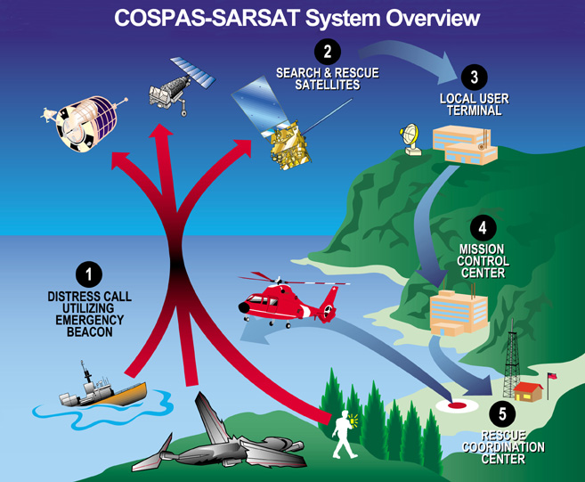
All the systems work something like this: A beacon is activated by a crash, a sinking, or manually by survivors. The beacon's transmission is picked up by one or more satellites. The satellite transmits the beacon's signal to its ground control station. The satellite's ground station processes the signals and forwards the data, including approximate location, to a national authority. The national authority forwards the data to a rescuing authority. The rescuing authority uses its own receiving equipment to locate the beacon and makes the rescue or recovery. Once the satellite data is in, it takes less than a minute to forward the data to any signatory nation.
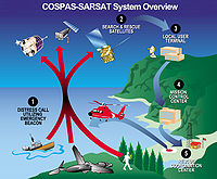 Overview diagram of EPIRB/COSPAS-SARSAT communication system
There are several systems in use, with beacons of varying expense, different types of satellites and varying performance. Note that even the oldest systems provide an immense improvement in safety, compared to not having a beacon.
GPS-based, registered
The most modern 406 MHz beacons with GPS (US$ $300+ in 2010) track with a precision of 100 meters in the 70% of the world closest to the equator, and send a serial number so the responsible authority can look up phone numbers to notify the registrator (e.g. next-of-kin) in four minutes.
The GPS system permits stationary, wide-view geosynchronous communications satellites to enhance the doppler position received by low Earth orbit satellites. EPIRB beacons with built-in GPS are usually called GPIRBs, for GPS Position-Indicating Radio Beacon or Global Position-Indicating Radio Beacon.
However, rescue cannot begin until a doppler track is available. The COSPAS-SARSAT specifications say [26] that a beacon location is not considered "resolved" unless at least two doppler tracks match or a doppler track confirms an encoded (GPS) track. One or more GPS tracks are not sufficient.
High-precision registered
An intermediate technology 406 MHz beacon (now mostly obsolete in favor of GPS enabled units) has worldwide coverage, locates within 2 km (12.5 km² search area), notifies kin and rescuers in 2 hours maximum (46 min average), and has a serial number to look up phone numbers, etc. This can take up to two hours because it has to use moving weather satellites to locate the beacon. To help locate the beacon, the beacon's frequency is controlled to 2 parts per billion, and its power is a hefty five watts.
Both of the above types of beacons usually include an auxiliary 25 milliwatt beacon at 121.5 MHz to guide rescue aircraft.
Traditional ELT, unregistered
The oldest, cheapest (US$ 139) beacons sent an anonymous warble at 121.5 MHz. They are no longer monitored by satellite. They could be detected by satellite over only 60% of the earth, required up to 6 hours for notification, located within 20 km (12 mi) (search area of 1200 km²) and were anonymous. Coverage was partial because the satellite had to be in view of both the beacon and a ground station at the same time—the satellites did not store and forward the beacon's position. Coverage in polar and south-hemisphere areas was poor. The frequency was the standard aviation emergency frequency, and there is interference from other electronic and electrical systems, so false alarms were common. To reduce false alarms, a beacon was confirmed by a second satellite pass, which could easily slow confirmation of a 'case' of distress to up to about 4 hours (although in rare circumstances the satellites could be position such that immediate detection becomes possible.) Also, the beacons couldn't be located as well because their frequency is only accurate to 50 parts per million, and they send only 75-100 milliwatts of power.
Location by Doppler (without GPS)
The Cospas-Sarsat system was made possible by Doppler processing. Local unit terminals (LUTs) detecting non-geostationary satellites interpret the Doppler frequency shift heard by LEOSAR and MEOSAR satellites as they pass over a beacon transmitting at a fixed frequency. The interpretation determines both bearing and range. The range and bearing are measured from the rate of change of the heard frequency, which varies both according to the path of the satellite in space and the rotation of the earth. This triangulates the position of the beacon. A faster change in the doppler indicates that the beacon is closer to the satellite's ground track. If the beacon is moving toward or away from the satellite track due to the Earth's rotation, it is on one side or other of the satellite's path.
If the beacon's frequency is more precise, it can be located more precisely, saving search time, so modern 406 MHz beacons are accurate to 2 parts per billion, giving a search area of only 2 square km, compared to the older beacons accurate to 50 parts per million that had 200 square kilometers of search area.
In order to increase the useful power, and handle multiple simultaneous beacons, modern 406 MHz beacons transmit in bursts, and remain silent for about 50 seconds.
Russia developed the original system, and its success drove the desire to develop the improved 406 MHz system. The original system was a brilliant adaptation to the low quality beacons, originally designed to aid air searches. It used just a simple, lightweight transponder on the satellite, with no digital recorders or other complexities. Ground stations listened to each satellite as long as it was above the horizon. Doppler shift was used to locate the beacon(s). Multiple beacons were separated when a computer program analysed the signals with a fast fourier transform. Also, two satellite passes per beacon were used. This eliminated false alarms by using two measurements to verify the beacon's location from two different bearings. This prevented false alarms from VHF channels that affected a single satellite. Regrettably, the second satellite pass almost doubled the average time before notification of the rescuing authority. However, the notification time was much less than a day.
Operational testing
According to the U.S. Federal Aviation Administration, ground testing of type A, B and S ELTs is to be done within the first 5 minutes of each hour. Testing is restricted to 3 audio sweeps. [4] Type I and II devices (those transmitting at 406 MHz) have a self test function and must not be activated except in an actual emergency.
The United States Coast Guard web page for EPIRBs states: "You may be fined for false activation of an unregistered EPIRB. The U.S. Coast Guard routinely refers cases involving the non-distress activation of an EPIRB (e.g., as a hoax, through gross negligence, carelessness or improper storage and handling) to the Federal Communications Commission. The FCC will prosecute cases based upon evidence provided by the Coast Guard, and will issue warning letters or notices of apparent liability for fines up to $10,000." [12]
Satellites used
Receivers are auxiliary systems mounted on several types of satellites. This substantially reduces the program's cost.
The weather satellites that carry the SARSAT receivers are in "ball of yarn" orbits, inclined at 99 degrees. The longest period that all satellites can be out of line-of-sight of a beacon is about two hours.
The first satellite constellation was launched in the early 1970s by the Soviet Union, Canada, France and the USA.
Some geosynchronous satellites have beacon receivers. Since end of 2003 there are four such geostationary satellites (GEOSAR) that cover more than 80% of the surface of the earth. As with all geosynchronous satellites, they are located above the equator. The GEOSAR satellites do not cover the polar caps.
Since they see the Earth as a whole, they see the beacon immediately, but have no motion, and thus no doppler frequency shift to locate it. However, if the beacon transmits GPS data, the geosynchronous satellites give nearly instantaneous response.
History
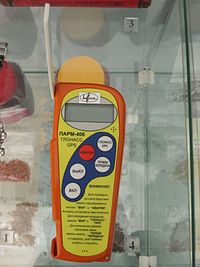 A PLB that can use either GLONASS or GPS location services
The original impetus for the program in the U.S. was the loss of Congressmen Hale Boggs (D-LA) and Nick Begich (D-AK) in the Alaskan wilderness on October 16, 1972. A massive search effort failed to locate them. The result was a U.S. law mandating that all aircraft carry an emergency locator transmitter. Technical and organizational improvements followed.
Cospas-Sarsat is an international organization that has been a model of international cooperation, even during the Cold War. SARSAT means Search And Rescue Satellite Aided Tracking. COSPAS (КОСПАС) is an acronym for the Russian words "Cosmicheskaya Sistema Poiska Avariynyh Sudov" (Космическая Система Поиска Аварийных Судов), which translates to "Space System for the Search of Vessels in Distress". A consortium of Russia, the U.S., Canada and France formed the organization in 1982. Since then 29 others have joined.
Cospas-Sarsat defines standards for beacons, auxiliary equipment to be mounted on conforming weather and communication satellites, ground stations, and communications methods. The satellites communicate the beacon data to their ground stations, which forward it to main control centers of each nation that can initiate a rescue effort.
The U.S. Coast Guard once promoted an emergency beacon on maritime VHF emergency channels. It now promotes the superior Cospas-Sarsat system, and no longer services emergency beacons on maritime VHF frequencies.
Current events
In a Safety Recommendation released September 2007, the U.S. National Transportation Safety Board once again recommended that the U.S. FAA require all aircraft have 406 MHz ELTs.[27] They first recommended this back in 2000 and after vigorous opposition by AOPA, the FAA declined to do so. This recommendation is apparently a reaction to the cessation of 121.5 MHz satellite processing. Citing two recent accidents, one with a 121.5 MHz ELT and one with a 406 MHz ELT, the NTSB concludes that switching all ELTs to 406 MHz is a necessary goal to work towards.[28]
Alternate technologies
There are also other personal devices in the marketplace which do not meet the standard for 406 MHz devices.
GPS Aircraft Tracking
Active Aircraft Tracking
There are several active aircraft tracking systems available on the market that use the bread-crumb approach to SAR. Rather than relying on an emergency locator transmitter to transmit upon impact, the next generation of emergency locating devices are active tracking devices that send position reports at regular time intervals. If the unit stops transmitting upon impact, the historical transmissions will give the last known location of the aircraft, its speed, direction and altitude. Tracking as an alternative or complement to current technology has recently been encouraged by the Coroner in New Zealand.[29]
SPOT
SPOT does not use the 406 MHz signal nor the system of satellites. Instead, it depends on the GlobalStar satellite system. It has richer features (for instance, can send many non-emergency signals) – but it does not work in as many places as 406 MHz PLBs – for instance under dense forest canopy or steep canyons.[30] When a user presses the "911" button on a SPOT device an emergency message containing the unit's identification and GPS location is transmitted to the GEOS International Emergency Response Center who then notifies the appropriate emergency agency for the region after first calling the user to ensure the transmission is not accidental.[31][32]
SPOT additionally has the ability to provide non-emergency web based tracking information. This allows family or friends at home to track the holder's progress. The tracking operates by sending a tracking signal to the GlobalStar network every 10 minutes. This feature can additionally be useful to provide location of an individual even if the individual is unable to activate the emergency '911' button.[33]
Typical costs are $169 plus a $99/year service fee for basic services or $150/yr for basic services and tracking services, as compared to around $250 for a 406-MHz PLB with no service fee.
inReach
inReach, like SPOT does not use the 406 MHz signal nor the system of satellites. Instead, it depends on the Iridium satellite system. Unlike SPOT inReach is a two way system capable of receiving confirmation that the message was received. Like SPOT the message is transmitted to the private GEOS International Emergency Response Center who then notifies the appropriate SAR authorities.
inReach also provides tracking capability and two way SMS type text messaging allowing family and friends to track and send and receive updates from the trail. Pricing starts at USD$9.95/mo with all messages pay as you go to USD$44.95 per month for unlimited tracking [34] and a message bundle.
TracMe
TracMe [35] simply beacons an automated message on a short-range FRS or UHF CB frequency. It does not notify authorities that you are missing. TracMe's website recommends you arrange for rescue by notifying a friend about your plans, and ask them to call authorities and inform them of your general whereabouts and that you have a TracMe if you are late returning.[36] Then, the search-and-rescue team will need to radio-triangulate on the signal.[37]
TracMe has had a dispute with the FCC whether the device can be called a "Personal Locator Beacon".[38]
The company lists it at a cost of $49.95 and it allows a single use. The company also promises a free replacement if it's used for a genuine emergency.
APRS
Automatic Position Reporting System is used by amateur radio operators to track positions and send short messages. Most APRS packets contain a GPS latitude and longitude, so they can be used for both normal and emergency tracking. They also are routed to the internet, where they are archived for some period of time, and viewable by others There are several Emergency packet types that can indicate distress. Since it is part of the amateur radio service, it costs nothing to transmit on and uses the extensive network, however, one must be a licensed amateur radio operator. There is also no guarantee that an APRS distress packet report would be seen or handled by emergency responders. It would have to be seen by an amateur radio operator and forwarded on.
See also
- Annex: Acronyms and abbreviations in avionics
- Civil Air Patrol (US Air Force Auxiliary)
- SPOT Satellite Messenger
- 1996 New Hampshire Learjet crash
- Aircraft emergency frequency
- Electric beacon
- Global Maritime Distress Safety System
- Search and Rescue Transponder
- Sumburgh disaster
- Survival radio
- Varig Flight 254
- ENOS Rescue-System
References
- ^ [1]
- ^ a b c Microsoft Word - G3Oct30.98D.
- ^ Milovanovich, C. (7 May 2009). "Inquest into the death of David Iredale". Lawlink. http://www.lawlink.nsw.gov.au/lawlink/Coroners_Court/ll_coroners.nsf/vwFiles/Iredalefindings.pdf/$file/Iredalefindings.pdf. Retrieved 20 February 2010.
- ^ Community Emergency Response Team Participant Handbook
- ^ a b Cospas-Sarsat Distress Alerts During 2006, Cospas-Sarsat
- ^ http://www.cospas-sarsat.com/DocumentsTSeries/T1Nov05.pdf
- ^ NASA Search and Rescue Mission Office : Distress Alerting Satellite System (DASS)
- ^ Example of 406 MHz Beacon Coding
- ^ beacon decoder webpage, When one enters the transmitted (i.e. GPS-location-included) 15-hex into the decoder, the unmodified 15-hex ID is printed at the bottom of the output of the Beacon Decoder page. This method can be used to confirm that a beacon is encoding the correct 15-hex ID (as printed on the side of the beacon) into its distress messages. Accessed November 23, 2009
- ^ a b RSS-187, Emergency Position Indicating Radio Beacons, Emergency Locator Transmitters, Personal Locator Beacons, and Maritime Survivor Locator Devices
- ^ KANNAD 406 AS
- ^ a b c d Position Indicating Radiobeacon (EPIRB) - USCG Navigation Center
- ^ RSS-187, Emergency Position Indicating Radio Beacons, Emergency Locator Transmitters, Personal Locator Beacons, and Maritime Survivor Locator Devices
- ^ 406 MHz beacons
- ^ U.S. Legal Personal Locator Beacons (PLBs)
- ^ 406 MHz Beacons
- ^ a b Cospas-Sarsat Phase-Out Page
- ^ [2] - Cospas-Sarsat - Summary Report of the 406 MHz Geostationary System Demonstration and Evaluation - "3.10 Combined LEOSAR/GEOSAR Operations (T-10)"
- ^ a b http://www.avionicswest.com/articles/eltupdate.htm
- ^ Use of 121.5/243 MHz EPIRBs Banned. BoatUS Magazine. March 2007.
- ^ http://www.airweb.faa.gov/Regulatory_and_Guidance_Library/rgTSO.nsf/0/0F451B230D34559F86256DAC0068F32A?OpenDocument TSO-126
- ^ Emergency Locator Transmitters
- ^ Regulations Amending the Canadian Aviation Regulations (Parts I and VI — ELT) Canada Gazette
- ^ Canada Backs Off 406 ELTs
- ^ [3]
- ^ See COSPAS-SARSAT document A.001, 2005
- ^ Safety recommendation (A-07-51). National Transportation Safety Board. 4 September 2007.
- ^ NTSB to FAA: Require 406 MHz ELTs | Doug Ritter’s Equipped.org Blog
- ^ Ihaka, James (27 May 2010). "Erceg coroner urges use of GPS tracking devices for aircraft". The New Zealand Herald. http://www.nzherald.co.nz/civil-aviation-authority/news/article.cfm?o_id=500463&objectid=10647692. Retrieved 28 September 2011.
- ^ http://www.equipped.org/SPOT_ORSummer2007.htm
- ^ SPOT Emergency Response
- ^ GEOS Search And Rescue
- ^ How SPOT works
- ^ http://shop.delorme.com/OA_HTML/DELibeCCtdItemDetail.jsp?item=31805§ion=10820
- ^ Official Web site http://www.tracme.com/
- ^ TracMe Official Web site FAQ.
- ^ TrackMe
- ^ http://www.equipped.org/blog/?p=71
- COSPAS-SARSAT, Document C/S T.001 October 1999
- FCC, Part 80 and GMDSS
- MED, 0735/2001
- RTCM, Standard for 406 MHz Satellite EPIRBs
External links
- Cospas-Sarsat – the International Satellite System For Search and Rescue
- ITU – Maritime mobile Access and Retrieval System (MARS)
- International Satellite System for Search and Rescue
- NOAA SARSAT website
- NOAA notice of planned phasing out of 121.5/243 MHz beacons in 2009
- ICAO/IMO Working Paper 10 to 14 September 2007 – Joint Working Group on Harmonization of Aeronautical and Maritime Search and Rescue
- Equipped To Survive Foundation – the most current and comprehensive information about EPIRBs
Categories:- Aircraft emergency systems
- Emergency communication
- Beacons
- Rescue equipment

Wikimedia Foundation. 2010.