- Muncy Historic District
-
Muncy Historic District
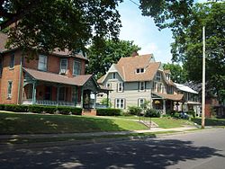 Muncy Historic District, July 2011

Location: Roughly bounded by Ridell Lane, Sherman, Washington and Mechanic Sts., Muncy, Pennsylvania Coordinates: 41°12′13″N 76°47′7″W / 41.20361°N 76.78528°WCoordinates: 41°12′13″N 76°47′7″W / 41.20361°N 76.78528°W Area: 151.9 acres (61.5 ha) Built: 1798 Architectural style: Late Victorian, Georgian, Federal Governing body: Local NRHP Reference#: 80003570[1] Added to NRHP: July 3, 1980 Muncy Historic District is a national historic district located at Muncy, Lycoming County, Pennsylvania. The district includes 298 contributing buildings in the central business district and surrounding residential area of Muncy. The buildings date as early as 1798, and are representative of Victorian, Georgian, and Federal style architecture. Notable buildings include the St. Andrew Lutheran Church, Muncy Presbyterian Church, William McCarty Residence, Walton-Weaver Residence, Gray-Bodine Residence, Boal-Griggs Building, Clapp-Muncy Historical Society Building, Jacob E. Cooke Row Houses, Clapp-Smith Building, Rankin-Brindle Building, Lloyd Building, Lycoming County Mutual Fire Insurance Building, Fahnestock-Petrikin Building, Muncy Valley House, and the D.O. Snyder Building. The St. James Episcopal Church, designed by Richard Upjohn, is listed separately on the National Register.[2]
It was added to the National Register of Historic Places in 1980.[1]
References
- ^ a b "National Register Information System". National Register of Historic Places. National Park Service. 2010-07-09. http://nrhp.focus.nps.gov/natreg/docs/All_Data.html.
- ^ ""National Historic Landmarks & National Register of Historic Places in Pennsylvania"" (Searchable database). CRGIS: Cultural Resources Geographic Information System. https://www.dot7.state.pa.us/ce/SelectWelcome.asp. Note: This includes Tim Ritchey (undated). "National Register of Historic Places Inventory Nomination Form: Muncy Historic District" (PDF). https://www.dot7.state.pa.us/ce_imagery/phmc_scans/H000615_01H.pdf. Retrieved 2011-11-19.
Categories:- Historic districts in Pennsylvania
- National Register of Historic Places in Pennsylvania
- Federal architecture in Pennsylvania
- Georgian architecture in Pennsylvania
- Buildings and structures in Lycoming County, Pennsylvania
- Pennsylvania Registered Historic Place stubs


Wikimedia Foundation. 2010.