- Dover, New York
-
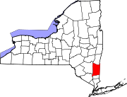
Dover, New York — Town — Downtown Dover Plains, NY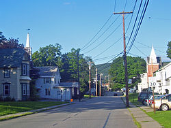 Location within the state of New York
 Dover, New York
Coordinates: 41°41′22″N 73°34′51″W / 41.68944°N 73.58083°WCoordinates: 41°41′22″N 73°34′51″W / 41.68944°N 73.58083°W Country United States State New York County Dutchess Government – Type Town Council – Town Supervisor Ryan Courtien(D) – Town Council Members' ListArea – Total 56.3 sq mi (145.9 km2) – Land 55.7 sq mi (144.3 km2) – Water 0.6 sq mi (1.7 km2) Elevation 479 ft (146 m) Population (2000) – Total 8,565 – Density 153.8/sq mi (59.4/km2) Time zone Eastern (EST) (UTC-5) – Summer (DST) EDT (UTC-4) FIPS code 36-20819 GNIS feature ID 0978906 Dover is a town in Dutchess County, New York, United States. The population was 8,565 at the 2000 census. The town was named after Dover in England, the home town of an early settler.
The Town of Dover is located on the eastern boundary of the county; North of Pawling, South of Amenia, West of the State of Connecticut.
Contents
History
In 1637 the Pequots having been driven from their former homes in Connecticut settled in what is now Dover. They were led by Gideon Mauwee for part of their time in this location.[1]
The town was formed in 1807 from part of the Town of Pawling. The first town meeting took place in the home of John Preston, an early settler. The home, built circa 1730, is now an inn and restaurant known as Old Drovers Inn.[1]
The Harlem Valley Psychiatric Center (1924–1994) was a major source of employment for Wingdale and the surrounding areas. When the Center was closed in 1994, many businesses in the area were hit hard. The brick & marble building on the grounds still stand, but many are dilapidated and in need to be torn down. (Demolition is slated to begin on 10/15/10 according to a sign on the property). The property and buildings were purchased in the 2003 by the Benjamin Development Corporation and currently is in the SEQRA process before the Town Board as Lead Agency for its redevelopment into a transit oriented town center known as Dover Knolls.
Geography
According to the United States Census Bureau, the town has a total area of 56.3 square miles (146 km2), of which, 55.7 square miles (144 km2) of it is land and 0.6 square miles (1.6 km2) of it (1.14%) is water.
The east town line is the border of Connecticut.
The Appalachian Trail passes through the town.
Government and emergency services
The Legislature and Executive of the Government of Dover, New York are invested in the Town Board, consisting of the Town Supervisor, currently the Honorable Ryan Courtien elected to a two-year term, and four Council members, currently the Honorable Christopher Galayda, the Honorable Catherine Frame, the Honorable Katie Palmer-House & the Honorable Richard Hawthorne, each elected to four-year terms. The Town Board is accountable for the health, safety and welfare of all citizens. The body is responsible for adopting and amending the Town Comprehensive or Master Plan, and can adopt zoning and land use regulations or issue other permits in addition to performing various administrative functions.
Town Comprehensive or Master Plan
The Master Plan directs the general action of the Government and serves a similar function as the US Constitution. The Plan contains nine chapters. Ch. 1: Community Values; Ch. 2: Historic Preservation; Ch. 3: Natural Resources; Ch. 4: Population and Economic Base; Ch. 5: Housing; Ch. 6: Community Facilities; Ch. 7: Transportation; Ch. 8: Existing Land Use; Ch. 9: Two-Part Summary of the Master Plan.
Volunteer boards
The Government also includes a series of volunteer boards.
The Zoning Board of Appeals interprets zoning laws and considers variance requests, which are requests for relief from zoning law.
The Planning Board considers site plans, subdivision proposals and special use permits. The Planning Board also reports on the adoption of official maps and amendments to zoning ordinance.
The Architectural and Community Appearance Review Board reviews all proposals for all construction in excess of 1,000 square feet (93 m2) of gross floor area and all signs to be erected on reviewed structures. Single-family residence proposals, two-family residence proposals and residence accessory structure proposals are normally not reviewed, except in special circumstances.
Departments
Much of the Function of the Government occurs in Town Departments. Office of the Supervisor is run by Supervisor Ryan Courtien includes the offices of the Supervisor, Human Resources/Civil Service Management and Finance.
Office of the Town Clerk is another department headed by an independent elected official Caroline Reichenberg. The Town Clerk is responsible for the collection and release of vital records of both the citizens (such as birth certificates, etc.) and the government (Town Board Meeting Minutes). The keeping of records of Local Laws and statistics and issuing of licenses and permits is handled by this department.
The Assessor Department deal with tax-exemption and assessment related grievances.
The Building Department deals with building permits and code enforcement. This department can utilize inspections for enforcement.
The Highway Department is led by the Highway Superintendent who is one of the independent elected officials in the Government of Dover. This department deals with road maintenance, road construction and road closures.
Recreation is headed by the Recreation Director who coordinates the public recreational services provided by or through the town such as Town Basketball, the public pool and the town day camp for children entering grades Pre-K to Sixth that is run at the public pool facility.
Tax Collector is responsible for collection of town and county property taxes and is an independent elected official also called the "Receiver of Taxes."
The Justice Court is the local court for the Town of Dover which handles local issues such as traffic violations. Both Town Justices are elected officials.
Fire
Dover has a fire protection district and contracts with the J. H. Ketcham Hose Company for fire and ambulance service. The fire company operates two stations: Station One is on Rt 22 in Dover Plains and Station Two is on Rt 55 in Wingdale. The department is capable of handling fires, rescues, extrications, medical emergencies, hazardous material incidents and natural disasters. JHK operates a varied fire apparatus fleet based out of two stations, consisting of four engines (36-11, 36-12, 36-13, 36-14), one aerial (36-45), two utility / brush trucks (36-61, 36-62) and two BLS Ambulances (36-71, 36-72). BLS EMS calls are handled by NDP EMS whom are contracted to provide the town one ambulance to provide 12 hours a day, 7 days a week ambulance service from 5am to 5pm. The department does have some of the better response times in Eastern Dutchess County, as it is one of the more active departments on the Route 22 corridor in Dutchess County.
Demographics
As of the census[2] of 2000, there were 8,565 people, 3,034 households, and 2,157 families residing in the town. The population density was 153.8 people per square mile (59.4/km²). There were 3,266 housing units at an average density of 58.6 per square mile (22.6/km²). The racial makeup of the town was 89.71% White, 5.50% African American, 0.33% Native American, 0.99% Asian, 0.06% Pacific Islander, 1.52% from other races, and 1.89% from two or more races. Hispanic or Latino of any race were 5.65% of the population.
There were 3,034 households out of which 38.6% had children under the age of 18 living with them, 55.8% were married couples living together, 10.2% had a female householder with no husband present, and 28.9% were non-families. 23.3% of all households were made up of individuals and 7.1% had someone living alone who was 65 years of age or older. The average household size was 2.74 and the average family size was 3.27.
In the town the population was spread out with 29.2% under the age of 18, 7.4% from 18 to 24, 32.2% from 25 to 44, 22.2% from 45 to 64, and 9.1% who were 65 years of age or older. The median age was 36 years. For every 100 females there were 106.4 males. For every 100 females age 18 and over, there were 101.7 males.
The median income for a household in the town was $50,361, and the median income for a family was $57,979. Males had a median income of $40,885 versus $28,542 for females. The per capita income for the town was $21,250. About 6.3% of families and 8.4% of the population were below the poverty line, including 10.6% of those under age 18 and 6.5% of those age 65 or over.
The population in 1890 was 1,863.
Transportation
Road
Although Dover has no major highways, it does have 2 major thoroughfares. Route 22 crosses from the Pawling town line to the Amenia town line. Route 343 goes through town as well.
Rail
Metro-North Railroad's Harlem Line runs through Dover with two rail commuter rail stations in town, with service to New York City via the Harlem Line, with the Harlem Valley – Wingdale at the former State Hospital & Route 22, and the Dover Plains right in the town center. Trains leave every two hours in each direction during middays, evenings and weekends. In rush hours, service in the peak direction operates about every 30 minutes.
Communities and locations in Dover
- Bains Corner : A hamlet east of Dover Plains.
- Chestnut Ridge : A hamlet at the town line in the northwest part of the town.
- Dogtail Corners : A hamlet by the east town line.
- Dover Furnace : A hamlet in the south part of the town, south of Dover Plains on Route 22.
- Dover Plains : A hamlet in the northeast part of the town.
- Ellis Pond : A small lake in the southeast part of the town.
- Lake Weil : A small lake in the southeast part of the town.
- Oniontown : A section of town off Route 22
- South Dover : A hamlet in the eastern part of the town.
- Webatuck : A hamlet in the southeastern part of the town on Route 55.
- Wingdale : A hamlet in the south part of the town on Route 22, home of Camp Ramah in the Berkshires.
Camp
Camp Ramah in the Berkshires (Wingdale, New York) is located on Lake Ellis.
References
- ^ Smith, James H., History of Dutchess County, New York. (Interlaken, New York: Heart of the Lakes Publishing, 1980) p. 20
- ^ "American FactFinder". United States Census Bureau. http://factfinder.census.gov. Retrieved 2008-01-31.
External links
Municipalities and communities of Dutchess County, New York Cities Beacon | Poughkeepsie
Towns Amenia | Beekman | Clinton | Dover | East Fishkill | Fishkill | Hyde Park | LaGrange | Milan | North East | Pawling | Pine Plains | Pleasant Valley | Poughkeepsie | Red Hook | Rhinebeck | Stanford | Union Vale | Wappinger | Washington
Villages CDPs Other
hamletsAnnandale-on-Hudson | Barrytown | Boston Corner‡ | Chelsea | Linden Acres | Mabbettsville | New Hamburg | Pleasant Plains | Quaker Hill | Rhinecliff | Salt Point | Shekomeko | Sylvan Lake | Van Keurens | Verbank | Wassaic
Footnotes ‡This populated place also has portions in an adjacent county or counties
Categories:- Towns in New York
- Poughkeepsie–Newburgh–Middletown metropolitan area
- Populated places in Dutchess County, New York


Wikimedia Foundation. 2010.