- Dover Plains (Metro-North station)
-
Dover Plains 
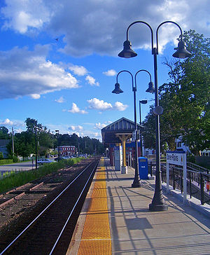
View south along track from the platformStation statistics Address Market Street & Mill Street
Dover Plains, New York, 12522Coordinates 41°44′34″N 73°34′34″W / 41.7427°N 73.5762°WCoordinates: 41°44′34″N 73°34′34″W / 41.7427°N 73.5762°W Lines Connections Dutchess County LOOP: D Platforms 1 side platform Tracks 1 Other information Accessible 
Fare zone 9 Services Preceding station Metro-North Railroad Following station toward Grand CentralHarlem Line toward Wassaic(Closed)toward Grand CentralHarlem Line The Dover Plains Metro-North Railroad station serves the residents of Dover Plains, New York via the Harlem Line. Trains leave for New York City every two hours, and about every 30 minutes during rush hour. It is 76.5 miles (123 km) from Grand Central Terminal and travel time to Grand Central is approximately two hours, two minutes.
The 7.5-mile (12 km) distance from Dover Plains to Harlem Valley – Wingdale, the next station to the south, is the longest between two stations on the Harlem Line.
The Ticket Agent/Office was closed in September 1981.
Platform and track configuration
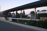
This station has one four-car-long high-level side platform to the west of the track. The Harlem Line has one track at this location.
History
Dover Plains was a terminal station from the beginning days of the New York Central Railroad until 2000. Besides passenger service, freight service also originated and stopped at this location, in both directions north and south.
External links
- Metro-North Railroad - Dover Plains
- List of upcoming train departure times from MTA
- Tour of the Harlem Line - Photos of Dover Plains
Categories:- Metro-North Railroad stations in New York
- Stations along New York Central Railroad lines
- Transportation in Dutchess County, New York
- New York railway station stubs
Wikimedia Foundation. 2010.

