- Old Town Green Historic District
-
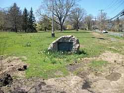
Old Town Green Historic DistrictHistoric Marker Stone at the Huntington Town Green
Location: Park Ave., Huntington, New York Coordinates: 40°52′29″N 73°24′52″W / 40.87472°N 73.41444°WCoordinates: 40°52′29″N 73°24′52″W / 40.87472°N 73.41444°W Area: 14 acres (5.7 ha) Architectural style: Federal Governing body: Private MPS: Huntington Town MRA NRHP Reference#: 85002586[1] Added to NRHP: September 26, 1985 Old Town Green Historic District is a national historic district located at Huntington in Suffolk County, New York. The district which has 14 contributing buildings, is officially located on Park Avenue, but expands west along West Main Street. It is a small residential enclave that includes the town green. This green contains an oak tree named "Constitution Oak," that was planted on the 200th Anniversary of New York State's ratification of the Constitution of the United States. Seven of the eight dwellings date to the settlement period in 1653. Located in the district are structures such as the Charles Woodhull House and the Fort Golgotha and the Old Burial Hill Cemetery.[2]
It was added to the National Register of Historic Places in 1985.[1]
References
- ^ a b "National Register Information System". National Register of Historic Places. National Park Service. 2009-03-13. http://nrhp.focus.nps.gov/natreg/docs/All_Data.html.
- ^ NYS Parks & Recreation (undated). "National Register of Historic Places Registration: Old Town Green Historic District". New York State Office of Parks, Recreation and Historic Preservation. http://www.oprhp.state.ny.us/hpimaging/hp_view.asp?GroupView=8737. Retrieved 2010-02-20. See also: "Accompanying 17 photos". http://www.oprhp.state.ny.us/hpimaging/hp_view.asp?GroupView=8756.
Categories:- Historic districts in New York
- National Register of Historic Places in New York
- Federal architecture in New York
- Historic districts in Suffolk County, New York
- Suffolk County, New York Registered Historic Place stubs
Wikimedia Foundation. 2010.


