- Christman Bird and Wildlife Sanctuary
-
Christman Bird and Wildlife Sanctuary
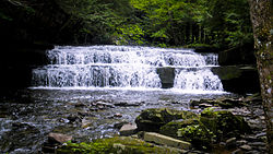
 The first waterfall encountered on the trail, around 0.8 miles in.
Location: Schoharie Tpke., Delanson, New York Coordinates: 42°44′27″N 74°7′30″W / 42.74083°N 74.125°WCoordinates: 42°44′27″N 74°7′30″W / 42.74083°N 74.125°W Area: 105 acres (42 ha) Built: 1888 Governing body: Private NRHP Reference#: 70000433
[1]Added to NRHP: August 25, 1970 Christman Bird and Wildlife Sanctuary is a national historic district located near Delanson, Schenectady County, New York. The district includes six contributing buildings and one contributing structure on a largely wooded, rural 105-acre (42 ha) tract. It lies in the valley of the Bozenkill and includes a 30-foot waterfall along the Helderberg Escarpment. Located on the property is a two story frame dwelling built in 1868, a stone dairy house, barns, large stone walls, and an open lean-to built by the Mohawk Valley Hiking Club. The sanctuary had its beginnings in 1888 when property owner W.W. Christman (1865-1937) and his wife, the former Catherine Bradt, began a winter bird feeding program during the great blizzard of that year.[2]
It was listed on the National Register of Historic Places in 1970.[1]
Gallery
External Links
References
- ^ a b "National Register Information System". National Register of Historic Places. National Park Service. 2009-03-13. http://nrhp.focus.nps.gov/natreg/docs/All_Data.html.
- ^ Paul R. Huey Sr. (March 1970). "National Register of Historic Places Inventory-Nomination: Christman Bird and Wildlife Sanctuary". New York State Office of Parks, Recreation and Historic Preservation. http://www.oprhp.state.ny.us/hpimaging/hp_view.asp?GroupView=8277. and Accompanying 12 photos
Categories:- Historic districts in New York
- National Register of Historic Places in New York
- Bird sanctuaries of the United States
- Schenectady County, New York Registered Historic Place stubs
Wikimedia Foundation. 2010.


