- Dalworthington Gardens, Texas
-
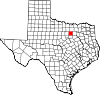
City of Dalworthington Gardens, Texas — City — Location of Dalworthington Gardens in Tarrant County, Texas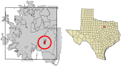
Coordinates: 32°41′48″N 97°9′21″W / 32.69667°N 97.15583°WCoordinates: 32°41′48″N 97°9′21″W / 32.69667°N 97.15583°W Country United States State Texas County Tarrant Area – Total 1.9 sq mi (4.8 km2) – Land 1.8 sq mi (4.7 km2) – Water 0.1 sq mi (0.1 km2) 1.08% Elevation 571 ft (174 m) Population (2000) – Total 2,186 – Density 1,193.8/sq mi (461.2/km2) Time zone CST (UTC-6) – Summer (DST) CDT (UTC-5) FIPS code 48-19084[1] GNIS feature ID 1333892[2] Website http://cityofdwg.net/ Dalworthington Gardens is a city in Tarrant County, Texas, United States. The population was 2,186 at the 2000 census.
The name is a portmanteau of parts of names of the three anchor cities of the Metroplex: Dallas, Fort Worth, and Arlington.
Contents
Geography
Dalworthington Gardens is located at 32°41′48″N 97°9′21″W / 32.69667°N 97.15583°W (32.696633, -97.155705)[3].
According to the United States Census Bureau, the city has a total area of 1.9 square miles (4.8 km²), of which, 1.8 square miles (4.7 km²) of it is land and 0.04 square miles (0.1 km²) of it (1.08%) is water.
The town's northern border adjoins Pantego; both towns are completely surrounded by the city of Arlington.
Demographics
As of the census[1] of 2000, there were 2,186 people, 747 households, and 622 families residing in the city. The population density was 1,193.8 people per square mile (461.2/km²). There were 765 housing units at an average density of 417.8 per square mile (161.4/km²). The racial makeup of the city was 89.52% White, 6.08% African American, 0.50% Native American, 1.56% Asian, 0.46% from other races, and 1.88% from two or more races. Hispanic or Latino of any race were 3.80% of the population.
There were 747 households out of which 41.2% had children under the age of 18 living with them, 73.5% were married couples living together, 7.9% had a female householder with no husband present, and 16.6% were non-families. 13.1% of all households were made up of individuals and 4.7% had someone living alone who was 65 years of age or older. The average household size was 2.92 and the average family size was 3.21.
In the city the population was spread out with 28.9% under the age of 18, 6.0% from 18 to 24, 27.3% from 25 to 44, 28.5% from 45 to 64, and 9.3% who were 65 years of age or older. The median age was 40 years. For every 100 females there were 97.3 males. For every 100 females age 18 and over, there were 95.8 males.
The median income for a household in the city was $75,528, and the median income for a family was $95,686. Males had a median income of $62,500 versus $30,978 for females. The per capita income for the city was $41,458. About 0.8% of families and 1.8% of the population were below the poverty line, including 2.6% of those under age 18 and 2.0% of those age 65 or over.
Education
No colleges or universities are present in this community, but the town lies in proximity to the University of Texas at Arlington (UTA). The community is also served by the Tarrant County College district of junior colleges which has campuses located in the surrounding cities.
Dalworthington Gardens lies within the Arlington Independent School District. Dalworthington Gardens is served by Key Elementary School, Gunn Junior High School, Martin High School, and Arlington High School.
In Texas, school district boundaries do not always follow city and county boundaries because all aspects of the school district government apparatus, including school district boundaries, are separated from the city and county government. In the case of Dalworthington Gardens, no Independent School District was ever established. The proximity of the already established Arlington ISD led to the entirety of Dalworthington Gardens being served by the AISD since the middle of the 20th century.
References
- ^ a b "American FactFinder". United States Census Bureau. http://factfinder.census.gov. Retrieved 2008-01-31.
- ^ "US Board on Geographic Names". United States Geological Survey. 2007-10-25. http://geonames.usgs.gov. Retrieved 2008-01-31.
- ^ "US Gazetteer files: 2010, 2000, and 1990". United States Census Bureau. 2011-02-12. http://www.census.gov/geo/www/gazetteer/gazette.html. Retrieved 2011-04-23.
External links
Dallas–Fort Worth–Arlington Counties Major cities Cities and towns
100k-300kCarrollton • Denton • Frisco • Garland • Grand Prairie • Irving • McKinney • Mesquite • Plano • RichardsonCities and towns
25k-99kAllen • Bedford • Cedar Hill • Cleburne • The Colony • Coppell • DeSoto • Duncanville • Euless • Farmers Branch • Flower Mound • Grapevine • Haltom City • Highland Village • Hurst • Keller • Lancaster • Lewisville • Mansfield • North Richland Hills • Rockwall • Rowlett • WylieCities and towns
10k-25kAddison • Balch Springs • Benbrook • Burleson • Colleyville • Corinth • Ennis • Forest Hill • Greenville • Saginaw • Seagoville • Southlake • Terrell • University Park • Watauga • Waxahachie • Weatherford • White SettlementMunicipalities and communities of Tarrant County, Texas Cities Arlington | Azle‡ | Bedford | Benbrook | Blue Mound | Burleson‡ | Colleyville | Crowley‡ | Dalworthington Gardens | Euless | Everman | Forest Hill | Fort Worth‡ | Grand Prairie‡ | Grapevine‡ | Haltom City | Haslet‡ | Hurst | Keller | Kennedale | Lake Worth | Mansfield‡ | Newark‡ | North Richland Hills | Pelican Bay | Reno‡ | Richland Hills | River Oaks | Saginaw | Sansom Park | Southlake‡ | Watauga | Westworth Village | White Settlement
Towns Edgecliff Village | Flower Mound‡ | Lakeside | Pantego | Trophy Club‡ | Westlake‡ | Westover Hills
CDPs Briar‡ | Pecan Acres‡ | Rendon
Unincorporated
communityAlliance‡
Footnotes ‡This populated place also has portions in an adjacent county or counties
Categories:- Dallas – Fort Worth Metroplex
- Cities in Texas
- Populated places in Tarrant County, Texas


Wikimedia Foundation. 2010.