- Crowley, Texas
-
City of Crowley, Texas — City — Location of Crowley in Tarrant County, Texas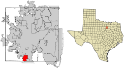
Coordinates: 32°34′37″N 97°21′35″W / 32.57694°N 97.35972°WCoordinates: 32°34′37″N 97°21′35″W / 32.57694°N 97.35972°W Country  United States
State  Texas
TexasCounties Tarrant, Johnson Government - Type Council-Manager - City Council Mayor Billy Davis
John Shotwell
Jerry Beck
Jesse Johnson
Jim Hirth
Tina Pace
Beau Yarborough- City Manager Truitt Gilbreath Area - Total 6.7 sq mi (17.2 km2) - Land 6.7 sq mi (17.2 km2) - Water 0 sq mi (0 km2) Elevation 778 ft (237 m) Population (2000) - Total 7,467 - Density 1,122.7/sq mi (433.5/km2) Time zone CST (UTC-6) - Summer (DST) CDT (UTC-5) ZIP code 76036 Area code(s) 817 FIPS code 48-17960[1] GNIS feature ID 1333742[2] Website ci.Crowley.TX.us Crowley is a city in Johnson and Tarrant counties in the U.S. state of Texas; virtually all of the city is in Tarrant County, with only about .01 sq mi in Johnson County. The population was 7,467 at the 2000 census.
Contents
Geography
Crowley is located at 32°34′37″N 97°21′35″W / 32.57694°N 97.35972°W (32.577027, -97.359797)[3].
According to the United States Census Bureau, the city has a total area of 6.7 square miles (17.2 km²), all land.
Crowley sits at the crossroads of Farm to Market Roads 1187 and 731, two miles west of Interstate 35W and 15 miles south of downtown Fort Worth.
History
Around 1848, pioneers began farming the area around Deer Creek. The settlement moved a mile or so west to the site of present day downtown Crowley when the Gulf, Colorado & Santa Fe Railroad built pens and laid tracks there. The first station depot was built in 1885. The community was named for S.H. Crowley, who was the master of transportation for the railroad.
An election to approve the incorporation of Crowley was held on February 3, 1951. The town council voted to change the designation of Crowley from town to city on September 3, 1972.
Demographics
As of the census[1] of 2000, there were 7,467 people, 2,650 households, and 2,098 families residing in the city. The population density was 1,122.7 people per square mile (433.5/km²). There were 2,748 housing units at an average density of 413.2 per square mile (159.6/km²).
All Figures as of the Census of 2000 Population 7,467 ( density 433.5/km² (1,122.7/sq mi)) Households 2,650 (2.81 people per household) Families 2,098 (3.16 people per family) Housing Units 2748 (average density: 159.6/km²(413.2/sq mi)) Racial Makeup
The racial makeup of the city was 93.08% White, 1.39% African American, 0.76% Native American, 0.48% Asian, 0.01% Pacific Islander, 2.29% from other races, and 1.98% from two or more races. Hispanic or Latino of any race were 7.81% of the population.
White (Caucasian): 93.08% (~ 6,950 people) Hispanic/Latino 7.81% (~ 586 people) Other races: 2.29% (~ 171 people) Two or more races 1.98% (~ 148 people) African American 1.39% (~ 104 people) Native American 0.76% (~ 57 people) Asian 0.48% (~36 people) Pacific Islander 0.01% (~1 person) Households
There were 2,650 households out of which 43.8% had children under the age of 18 living with them, 59.7% were married couples living together, 15.1% had a female householder with no husband present, and 20.8% were non-families. 17.5% of all households were made up of individuals and 6.8% had someone living alone who was 65 years of age or older. The average household size was 2.81 and the average family size was 3.16.
Married Couples living together 59.7% (~ 1,583 households) Households with children under the age of 18 43.8% (~ 1,161 households) Non-families 20.8% (~ 551 households) Households made up of individuals 17.5% (~ 464 households) Female householder with no husband present 15.1% (~ 400 households) Someone living alone who is 65 years of age or older 6.8% (~ 180 households) Age
In the city the population was spread out with 30.9% under the age of 18, 8.5% from 18 to 24, 30.5% from 25 to 44, 21.6% from 45 to 64, and 8.5% who were 65 years of age or older. The median age was 34 years.
Under 18 30.9% ( ~ 2,307 people) 18 to 24 8.5% ( ~ 635 people) 25 to 44 30.5% ( ~ 2,277 people) 45 to 64 21.6% ( ~ 1,613 people) 65 or older 8.5% (~ 650 people) Median Age 34 years Sex
For every 100 females there are 90.2 males. For every 100 females age 18 and over, there were 84.8 males.
Male to Female Ratio 100 females : 90.2 males Male to Female Ratio (18 and over) 100 females : 84.8 males Income
The median income for a household in the city was $46,765, and the median income for a family was $47,642. Males had a median income of $36,029 versus $26,035 for females. The per capita income for the city was $18,282.
Medium Income (Household) $46,765 Medium Income (Family) $47,642 Males $36,029 Females $26,035 Per capita (for each person) $18,282 Poverty
About 5.5% of families and 6.5% of the population were below the poverty line, including 7.7% of those under age 18 and 4.3% of those age 65 or over.
Population Below Poverty Line 6.5% (~ 485 people) Families Below Poverty Line 5.5% (~ 115 families) % Poverty < 18 years old 7.7% ( ~ 37 people) % Poverty > 65 years old 4.3% ( ~ 21 people) Education
The Crowley Independent School District extends north into Fort Worth. Most of the district's schools are located within the Fort Worth city limits, including North Crowley High School and 9th Grade Campus, Crowley Middle School, Sue Crouch Intermediate School, and eight elementary schools. Crowley High School and 9th Grade Campus, H.F. Stevens Middle School, and two elementary schools are within the Crowley city limits.
Popular culture
- The computer game Dark Seed II is set in Crowley but there is no resemblance to the actual city. It is the hometown of the protagonist Mike Dawson, who suffered a nervous breakdown from the events of the previous game.
Sources
- United States Census Bureau
- Crowley Area Chamber of Commerce
References
- ^ a b "American FactFinder". United States Census Bureau. http://factfinder.census.gov. Retrieved 2008-01-31.
- ^ "US Board on Geographic Names". United States Geological Survey. 2007-10-25. http://geonames.usgs.gov. Retrieved 2008-01-31.
- ^ "US Gazetteer files: 2010, 2000, and 1990". United States Census Bureau. 2011-02-12. http://www.census.gov/geo/www/gazetteer/gazette.html. Retrieved 2011-04-23.
External links
Dallas–Fort Worth–Arlington Counties Major cities Cities and towns
100k-300kCarrollton • Denton • Frisco • Garland • Grand Prairie • Irving • McKinney • Mesquite • Plano • RichardsonCities and towns
25k-99kAllen • Bedford • Cedar Hill • Cleburne • The Colony • Coppell • DeSoto • Duncanville • Euless • Farmers Branch • Flower Mound • Grapevine • Haltom City • Highland Village • Hurst • Keller • Lancaster • Lewisville • Mansfield • North Richland Hills • Rockwall • Rowlett • WylieCities and towns
10k-25kAddison • Balch Springs • Benbrook • Burleson • Colleyville • Corinth • Ennis • Forest Hill • Greenville • Saginaw • Seagoville • Southlake • Terrell • University Park • Watauga • Waxahachie • Weatherford • White SettlementMunicipalities and communities of Johnson County, Texas Cities 
Towns Unincorporated
communityFootnotes ‡This populated place also has portions in an adjacent county or counties
Municipalities and communities of Tarrant County, Texas Cities Arlington | Azle‡ | Bedford | Benbrook | Blue Mound | Burleson‡ | Colleyville | Crowley‡ | Dalworthington Gardens | Euless | Everman | Forest Hill | Fort Worth‡ | Grand Prairie‡ | Grapevine‡ | Haltom City | Haslet‡ | Hurst | Keller | Kennedale | Lake Worth | Mansfield‡ | Newark‡ | North Richland Hills | Pelican Bay | Reno‡ | Richland Hills | River Oaks | Saginaw | Sansom Park | Southlake‡ | Watauga | Westworth Village | White Settlement
Towns Edgecliff Village | Flower Mound‡ | Lakeside | Pantego | Trophy Club‡ | Westlake‡ | Westover Hills
CDPs Briar‡ | Pecan Acres‡ | Rendon
Unincorporated
communityAlliance‡
Footnotes ‡This populated place also has portions in an adjacent county or counties
Categories:- Dallas – Fort Worth Metroplex
- Cities in Texas
- Populated places in Tarrant County, Texas
- Populated places in Johnson County, Texas
- Crowley, Texas


Wikimedia Foundation. 2010.