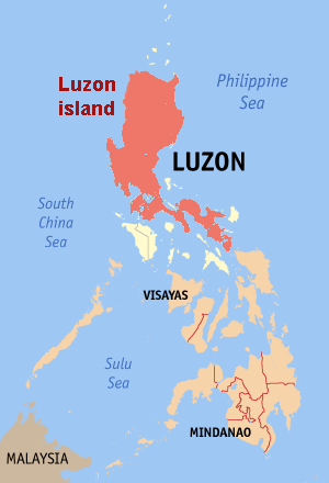
- Luzon
-
For the community in California, see Luzon, California.
Luzon 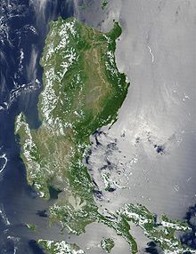
This MODIS true-color image of the northern Philippines shows the island of Luzon
Geography Location South East Asia Archipelago Philippine islands Major islands Luzon and Mindoro Area 104,688 km2 (40,420.3 sq mi) Area rank 17th Highest elevation 2,922 m (9,587 ft) Highest point Pulag Country PhilippinesRegions National Capital Region, Bicol, Cagayan Valley, CALABARZON, Central Luzon, Cordillera, Ilocos Largest city Quezon City (pop. 2,679,450) Demographics Population 46,228,000 [1][2] (as of 2007) Density 441.6 /km2 (1,143.7 /sq mi) Ethnic groups Aeta, Bicolano, Ibanag, Igorot, Ilokano, Kapampangan, Pangasinan, Tagalog Luzon (pronounced /luːˈzɑːn/) is the largest island in the Philippines. It is located in the northernmost region of the archipelago, and is also the name for one of the three primary island groups in the country centered on the Island of Luzon (the other two being the Visayas and Mindanao). Luzon as an island group includes the island of Luzon itself, plus the Batanes and Babuyan groups of islands to the north, and the main and outlying islands of Catanduanes, Marinduque, Masbate, Romblon, and Mindoro in the south.[3] Luzon is the economic and political center of the Philippines, being home to the country's capital city, Manila.
Contents
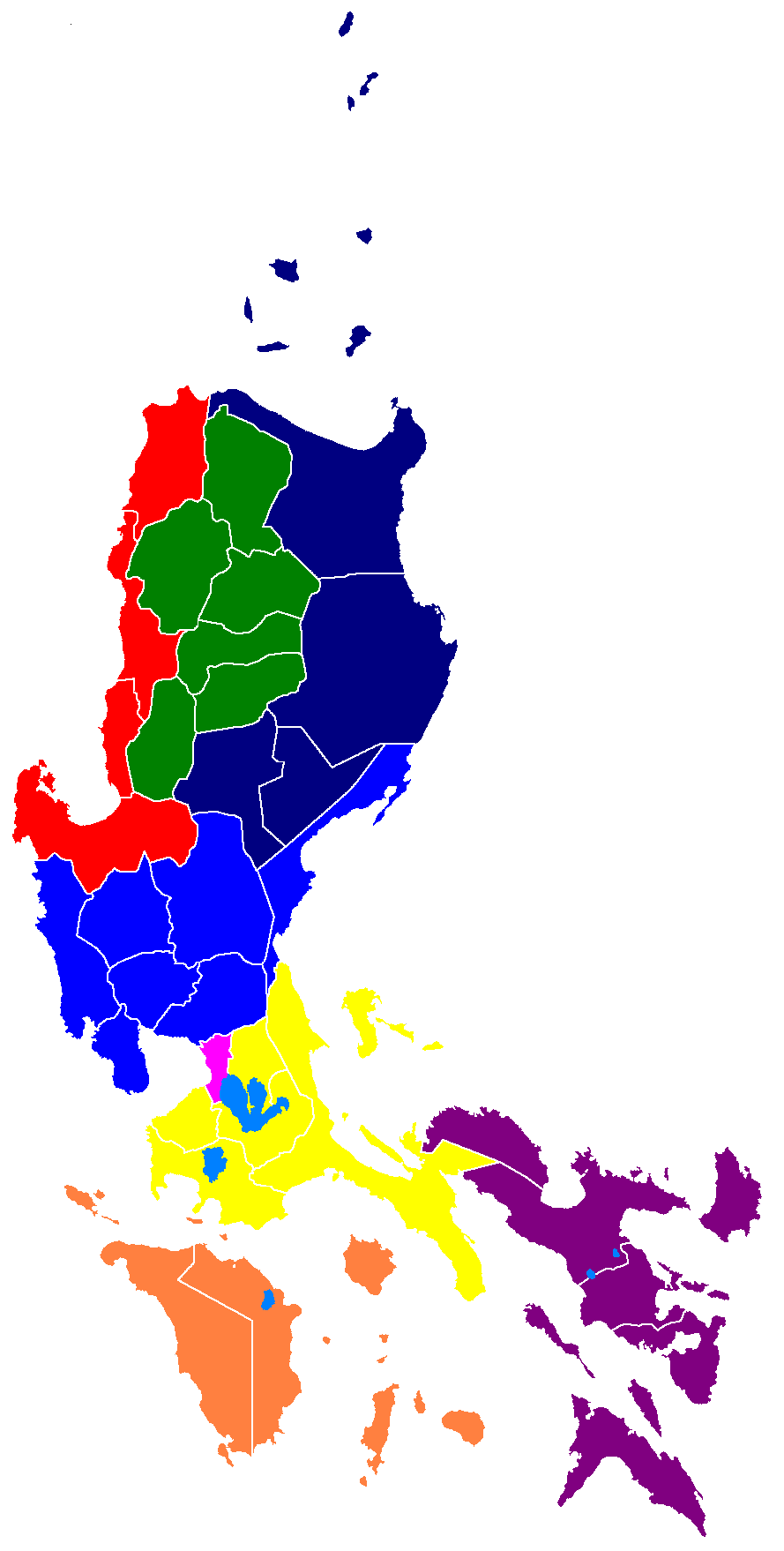
Administrative divisions
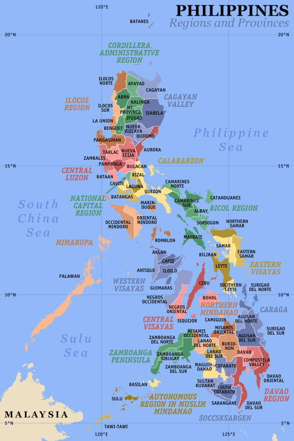
The island of Luzon contains 8 of the 17 administrative regions of the Philippines. These regions are not political entities, but merely serve as administrative groupings of provinces. They are:
- Ilocos Region (Region I),
- Cagayan Valley (Region II)
- Central Luzon (Region III)
- CALABARZON (Region IV-A)
- MIMAROPA (Region IV-B)
- Bicol Region (Region V)
- Cordillera Administrative Region (CAR)
- National Capital Region (NCR)
Ilocos Region (Region I) is on the northweast side of the island and faces South China Sea. The region is well known for its white sand coastline and rich history. Its provinces are Ilocos Norte, Ilocos Sur, La Union, and Pangasinan. The region's administrative centers is San Fernando City, La Union.
Cagayan Valley (Region II) is located in the northeast portion of the main island and also covers the Batanes and Babuyan islands to the north. The valley is surrounded by the Cordillera Central and Sierra Madre mountain ranges. Running through its center is the country's longest river, Cagayan River. Its provinces are Batanes, Cagayan, Isabela, Nueva Vizcaya, and Quirino. The region's administrative centers is Tuguegarao City.
Central Luzon (Region III) contains the largest plain of the country and produces most of the country's rice supply. Its provinces are Aurora, Bataan, Bulacan, Nueva Ecija, Pampanga, Tarlac, and Zambales. The region's administrative center is the City of San Fernando, Pampanga. The former United States Navy base of Subic Bay is located in Subic, Zambales while the former United States Air Force is in Clark Field, Pampanga. Both are now two of the country's booming special economic zones. The main languages are Kapampangan and Tagalog.
CALABARZON (Region IV-A), one of the newest regions of the country, was previously a part of Southern Tagalog (Region IV). It is one of the most populous areas of the country. The name of the region is actually an acronym that stands for its provinces, which are Cavite, Laguna, Batangas, Rizal, and Quezon. The Tagalogs are the dominant ethnic group in this region, with Tagalog as the main language. Its recognized administrative center is Manila, which is in Metro Manila, however, some government officials still consider Quezon City, which is also in Metro Manila as the administrative center, and also, Lucena City.
MIMAROPA (Region IV-B), along with CALABARZON is the newest region of the country, and was previously a part of Southern Tagalog (Region IV). It contains most of the islands in the Luzon group. The name of the region is actually an acronym that stands for its provinces, which are Marinduque, Occidental Mindoro, Oriental Mindoro, Palawan and Romblon. The region's administrative center is Calapan City.
Bicol Region (Region V) occupies the Bicol Peninsula at the southeastern end of Luzon island, plus the outlying islands which include the island provinces of Catanduanes and Masbate. The remaining mainland provinces are Albay, Camarines Norte, Camarines Sur, and Sorsogon. The region's administrative center is Legazpi City. The inhabitants are of Bicolano descent with Bikol as the main language.
Cordillera Administrative Region (CAR) almost completely covers the Cordillera Central mountain range of Northern Luzon. CAR, created in 1989 is a special administrative region for the indigenous tribes of these mountains. Its provinces are Abra, Apayao, Benguet, Ifugao, Kalinga, and Mountain Province. The regional center is Baguio City.
National Capital Region (NCR) is a special administrative region that contains the capital of the country, Manila; the country's most populous city, Quezon City; and an additional 15 more cities and municipalities. The region is more popularly known as Metro Manila. It is the only region in the country that has no provinces, and is the most densely populated with over 10 million people living in a 636 km² area.
Luzon is sometimes divided into three areas: Northern Luzon, Southern Luzon and Metro Manila. Northern Luzon are the regions north of Metro Manila (Regions I, II, III and CAR), while Southern Luzon are regions to the south and east of it (Regions IV-A, IV-B and V). In some statistics, Metro Manila is included within Southern Luzon.
Geography
See also: Geography of the PhilippinesLuzon's area is 104,688 square kilometers, making it the world's 17th largest island. It is the fifth most populated island in the world. Located on Luzon are the country's capital, Manila, and its most populated city, Quezon City. The island is very mountainous and is home to Mount Pulag, the third highest mountain in the country and Mount Pinatubo, Mayon, and Taal Volcano, Luzon's most famous volcanoes. To the west of Luzon island is the South China Sea (Luzon Sea in Philippine territorial waters), to the east is the Philippine Sea, and to the north is Luzon Strait containing Babuyan Channel and Balintang Channel.
The main part of the island is roughly rectangular in shape and has the long Bicol Peninsula protruding to the southeast. The northern part of the island contains the large mountain range, the Cordillera Central which is covered in a mixture of Luzon tropical pine forests and Luzon montane rain forests. Mount Pulag, the highest mountain in Luzon is located here, rising 2,922 meters.
To the east of the Cordillera Central is the large Cagayan Valley, which serves as the basin for the Cagayan River, the longest river in the Philippines. To the east of the valley rises the Sierra Madre mountain range, easily the longest range in the country.
The Sierra Madre snakes southwards into the central and southern part of the island. Between it and the Zambales Mountains to the west is the largest plain, the Central Luzon plain. This plain, approximately 11,000 km² in size, is the country's largest producer of rice. Among the rivers irrigating this plain, the longest are Cagayan to the north, and Pampanga to the south. In the middle of the plain rises the solitary Mount Arayat. To the west, in the Zambales Mountains, rises Mount Pinatubo, made famous because of its enormous 1991 eruption.
The Zambales mountains extends to the sea in the north, forming Lingayen Gulf, home to the Hundred Islands National Park. To the south, the mountains also extend into the sea, forming the Bataan Peninsula, which encloses the Manila Bay. This natural harbor is considered to be one of the best natural ports in East Asia, due to its size and strategic geographical location.
To the southeast of Manila Bay is the largest lake in the country, and also the largest inland lake in Southeast Asia, the Laguna de Bay (Old Spanish, Lake of Bay town). This 949 km² lake is drained by the Pasig River into Manila Bay. Pasig River is one of the most important rivers in the country due to its historical significance and because it runs through the center of Metro Manila.
Located just 20 km southwest of Laguna de Bay is Taal Lake, within the southwestern portion of the island. This caldera of a lake contains the smallest volcano of the country, Taal Volcano, which rises on the island in the center of the lake. The volcano in turn has a lake in its crater. All the surrounding areas of Taal Lake were once part of a massive prehistoric volcano that covered the southern portion of the province of Cavite, Tagaytay City, and the whole of Batangas province.
Off the southwestern portion of Luzon is the island of Mindoro, separated by the Verde Island Passages. The passages connect the South China Sea to the east with the Tayabas Bay. To the south of the bay is the island of Marinduque.
The southeastern portion of Luzon is dominated by the Bicol Peninsula. This is a mountainous and narrow region that extends approximately 150 km southeast. Along it are numerous gulfs and bays. In the north is Lamon Bay, which contains Alabat Island and is south of the Polillo Islands of Quezon province. Other bays and gulfs include San Miguel Bay, Lagonoy Gulf, Ragay Gulf, and Sorsogon Bay.
To the east of the peninsula lies the island of Catanduanes. Leading to it is the Caramoan Peninsula. Off the southeast tip of Bicol is Samar island, separated by San Bernardino Strait. Bicol Peninsula is connected to the main part of Luzon through the Tayabas Isthmus. Extending south from the isthmus is the Bondoc Peninsula.
The Bicol Peninsula is also home to numerous volcanoes. The most famous is Mayon Volcano in Albay. This 2,460 m high volcano is symmetrically shaped, rivaling that of Mount Fuji in Japan, and is a symbol of the Bicol Region. Other notable mountains are Mount Isarog and Mount Iriga in Camarines Sur, and Mount Bulusan in Sorsogon.
Located off the southwestern coast of the Bicol Peninsula are the islands of Ticao, Burias, and Masbate.
Tectonics
Main article: Philippine Mobile BeltLuzon is part of the Philippine Mobile Belt, a fast deforming plate boundary zone (Gervasio, 1967) hemmed in between two opposing subduction zones, the west-dipping Philippine Trench-East Luzon Trench subduction zone, and the east-dipping north-south trending Manila Trench-Negros Trench-Cotabato Trench.[4] The Philippine Sea Plate subducts under eastern Luzon along the East Luzon Trench and the Philippine Trench, while the South China Sea basin, part of the Eurasian plate, subducts under western Luzon along the Manila Trench.
The North-Southeastern trending braided left-lateral strike-slip Philippine Fault System traverses Luzon, from Quezon province and Bicol to the northwestern part of the island. This fault system takes up part of the motion due to the subducting plates and produces large earthquakes. Southwest of Luzon is a collision zone where the Palawan micro-block collides with SW Luzon, producing a highly seismic zone near Mindoro island. Southwest Luzon is characterized by a highly volcanic zone, called the Macolod Corridor, a region of crustal thinning and spreading.
Using geologic and structural data, seven principal blocks were identified in Luzon in 1989: the Sierra Madre Oriental, Angat, Zambales, Central Cordillera of Luzon, Bicol, and Catanduanes Island blocks.[5] Using seismic and geodetic data, Luzon was modeled by Galgana et al. (2007) as a series of six micro blocks or micro plates (separated by subduction zones and intra-arc faults), all translating and rotating in different directions, with maximum velocities ~100 mm/yr NW with respect to Sundaland/Eurasia.
Economy
The economy of the island is centered in Metro Manila with Makati City serving as the main economic and financial hub. Major companies such as Ayala, Jollibee Foods Corporation, SM Group, and Metrobank are based in the business districts of Makati, Ortigas Center, and Bonifacio Global City. Industry is concentrated in and around the urban areas of Metro Manila while agriculture predominates in the other regions of the island producing crops such as rice, bananas, mangoes, coconuts, pineapple, and coffee.[6] Other sectors include livestock raising, tourism, mining, and fishing.
History
Main articles: Kingdom of Tondo, Kingdom of Namayan, and Kingdom of MaynilaLuzon was once split among Hindu-Buddhist kingdoms, Muslim principalities, and ethnoreligious tribes, who had trading connections with Borneo, Malaya, Java, Indochina, India, Okinawa, Japan and China before the Spanish established their rule. From just before the first millennium, the Tagalog and Kapampangan peoples of south and central Luzon had established several Indianized kingdoms, notably among them those of Tundok, Namayan and Maynila. The Laguna Copperplate Inscription, the first Philippine document written in 900AD, names places in and around Manila Bay as well as Medan in Indonesia.[7] These kingdoms were based on leases between village rulers (Datu) and landlords (Lakan) or Rajahs, to whom tributes and taxes were levied. These kingdoms were coastal thalassocracies based on trade with neighboring Asian political entities at that time. According to sources at the time, the trade in large native Rusun-tsukuri (literally Luzon made in Japanese:呂宋製 or 呂宋つくり) clay jars used for storing green tea and rice wine with Japan flourished in the 12th century, and local Tagalog and Kapampangan potters had marked each jar with Baybayin letters denoting the particular urn used and the locale the jars were manufactured in.[8][9] Of this flourishing trade, the Burnay jars of Ilocos are the only large clay jar manufactured in Luzon today with origins from this time.
The Portuguese were the first European explorers who recorded it in their charts as Luçonia or Luçon and inhabitants were called Luçoes.[10]
The Spanish arrival in the 16th century saw the breaking up of these kingdoms and the establishment of the Philippines with its capital Cebu, which was moved to Manila following the defeat of the local Rajah Sulayman in 1570. Under Spain, Luzon also came to be known as the Nueva Castilla or the New Castile.
Demographics
 Map of the dominant Ethnolinguistic groups of the Philippines
Ethnic groups
Main article: Ethnic groups of the PhilippinesThe people of Luzon belong to the Filipino people, and are divided into several ethnolinguistic groups. These groups inhabit different areas of the island.
Ilocanos predominate in the northern portion of Ilocos and the region of Cagayan Valley, Pangasinense primarily inhabit Pangasinan, while the Kapampangans primarily live in Pampanga, Tarlac and the rest of Central Luzon. Meanwhile, Tagalogs are the majority in Bulacan, CALABARZON, and Metro Manila, while Bicolanos predominate in Bicol. Other ethnic groups are also present such as the Aeta of Zambales, the Ibanag of Cagayan, and the Igorot of the Cordilleras.
Due to recent migrations populations of Hindus, Moros, and Chinese have also been present in urban areas. Populations of Spanish, Americans, Japanese, Koreans, Desis, and Filipino mestizos are also visible. Most Americans have settled in Angeles City and Olongapo City due to the former presence of the U.S. air and naval bases in Central Luzon.
Languages
Main article: Languages of the PhilippinesAlmost all of the languages of Luzon belong to the Borneo–Philippines group of the Malayo-Polynesian language branch of the Austronesian language family. Major regional languages include: Tagalog, Ilocano, Kapampangan, Bicol, and Pangasinense. English is also used by many inhabitants.
Spain ruled the Philippines for 300 years. Spanish was the language of Philippine Revolution, and the 1899 Malolos Constitution proclaimed it as the official language. However, its use declined following the American occupation of the Philippines, it is still used by the elderly members of some families of great tradition (Rizal, Liboro...)
Religion
Main article: Religion in the PhilippinesThe major religion present in the island is Christianity, the Roman Catholic Church having the major denomination. Other sects include Protestantism, the Philippine Independent Church, and Iglesia ni Cristo.[11] Indigenous traditions and rituals are also present.
Sizable communities of Buddhists and Muslims have also began to be present in Metro Manila due to migrations of Moros and Chinese.
See also
References
- ^ Philippines 2007 Census
- ^ Figure composed of the 8 administrative regions excluding the island provinces of Batanes, Catadunes, and Masbate and the region MIMAROPA/MIMARO
- ^ Zaide, Sonia M.. The Philippines, a Unique Nation. p. 50.
- ^ Hashimoto, M, ed., Accretion Tectonics in the Circum-Pacific Regions, ISBN 9027715610 p299
- ^ Rangin and Pubellier in Tectonics of Circum-Pacific Continental Margins ISBN 9067641324 p148 fig 4
- ^ Index of Agriculture and Fishery Statistics. Census.gov.ph. Retrieved on 2010-12-19.
- ^ Laguna Copperplate Inscription – Article in English. Mts.net (2006-07-14). Retrieved on 2010-12-19.
- ^ Kekai, Paul. (2006-09-05) Quests of the Dragon and Bird Clan: Luzon Jars (Glossary). Sambali.blogspot.com. Retrieved on 2010-12-19.
- ^ South East Asia Pottery – Philippines. Seapots.com. Retrieved on 2010-12-19.
- ^ Pires, Tomé, A suma oriental de Tomé Pires e o livro de Francisco Rodriguez: Leitura e notas de Armando Cortesão [1512–1515], translated and edited by Armando Cortesao, Cambridge: Hakluyt Society, 1944.
- ^ PHILIPPINES: ADDITIONAL THREE PERSONS PER MINUTE National Statistics Office. Retrieved November 27, 2006.
External links
Categories:- Islands of the Philippines
- Luzon
- Super Regions of the Philippines


Wikimedia Foundation. 2010.