- Davao Oriental
-
Davao Oriental — Province — 
SealMap of the Philippines with Davao Oriental highlighted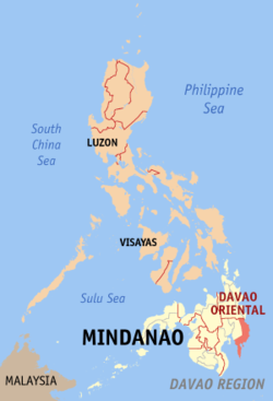
Coordinates: 7°10′N 126°20′E / 7.167°N 126.333°ECoordinates: 7°10′N 126°20′E / 7.167°N 126.333°E Country  Philippines
Region Davao Region (Region XI) Founded May 8, 1967 Capital Mati Government - Type Province of the Philippines - Governor Corazon Nunez-Malanyaon (Nacionalista) - Vice Governor Jose Mayo Almario (Lakas-Kampi-CMD) Area - Total 5,670.07 km2 (2,189.2 sq mi) Area rank 17th out of 80 Population (2007) - Total 486,104 - Rank 55th out of 80* - Density 85.7/km2 (222/sq mi) - Density rank 69th out of 80* Divisions - Independent cities 0 - Component cities 1 - Municipalities 9 - Barangays 183 - Districts 1st and 2nd districts of Davao Oriental Time zone PHT (UTC+8) ZIP Code Spoken languages Cebuano, Mandaya * Population and population density figures do not include the 4,955 persons residing in areas disputed by this province and Surigao del Sur. Davao Oriental (Filipino: Silangang Dabaw) is a province of the Philippines located in the Davao Region in Mindanao. Its capital is Mati and borders Compostela Valley to the west, and Agusan del Sur and Surigao del Sur to the north. Davao Oriental is the easternmost province of the country with Pusan Point as the easternmost location. The Philippine Sea, part of the Pacific Ocean, faces Davao Oriental to the east. Part of the province lies on an unnamed peninsula that encloses the Davao Gulf to the west.
Contents
People and culture
The native dialects spoken in this province are Kamayo and Mandaya.
Folklore beliefs include fairies (diwatas).
Homes are usually made out of wood, with bamboo figuring prominently in many rural abodes.
Economy
Davao Oriental is the copra (dried coconut meat) producer capital of the Philippines.
Geography
Political
Davao Oriental is subdivided into 11 municipalities and 1city.
City
- Mati City
Municipalities
Physical
Tourist attractions
Tagtalisay Beach, Masao Beach Resort, Botona Beach Resort, Dahican Beach, People's Park, Capitol Hills, Buso Hot Spring, Pujada Bay, Pujada Island, Sleeping Dinosaur, Dao Beach Club, Waniban Island, Gregorio Masao Beach Resort, Philippine Eagle Sanctuary. deo Beach.
History
In 1942, occupied by the Japanese Imperial forces in the province of Eastern Davao
In 1945, beginning the Battle of Davao from the combined forces of the British, Australian, Dutch and the Filipino troops of the 6th, 101st, 102nd, 103rd, 104th, 106th, 107th and 110th Infantry Division of the Philippine Commonwealth Army and 10th Infantry Regiment of the Philippine Constabulary was supported by the recognized Davaoeño guerrilla fighter units by the attack to the Japanese Imperial forces during the liberation in Eastern Davao or Eastern Davao Campaign until the end of the Second World War.
External links
Municipalities: Baganga • Banaybanay • Boston • Caraga • Cateel • Governor Generoso • Lupon • Manay • San Isidro • Tarragona Cities of the PhilippinesHighly-urbanized Cities Angeles · Bacolod · Baguio · Butuan · Cagayan de Oro · Caloocan · Cebu · Davao · General Santos · Iligan · Iloilo · Lapu-Lapu · Las Piñas · Lucena · Makati · Malabon · Mandaluyong · Mandaue · Manila · Marikina · Muntinlupa · Navotas · Olongapo · Parañaque · Pasay · Pasig · Puerto Princesa · Quezon · San Juan
Independent
Component CitiesCotabato · Dagupan · Naga, Camarines Sur · Ormoc · Santiago
Component Cities Alaminos · Antipolo · Bago · Bais · Balanga · Batangas · Batac · Bayawan · Baybay · Bayugan · Biñan · Bislig · Bogo · Borongan · Cabadbaran · Cabanatuan · Cadiz · Calamba · Calapan · Calbayog · Candon · Canlaon · Carcar · Catbalogan · Cauayan · Cavite · Danao · Dapitan · Dasmariñas · Digos · Dipolog · Dumaguete · El Salvador · Escalante · Gapan · Gingoog · Guihulngan · Himamaylan · Iriga · Isabela · Kabankalan · Kidapawan · Koronadal · La Carlota · Lamitan · Laoag · Legazpi · Ligao · Lipa · Maasin · Malaybalay · Malolos · Marawi · Masbate · Mati City · Meycauayan · Muñoz · Naga, Cebu · Oroquieta · Ozamiz · Pagadian · Palayan · Panabo · Passi · Roxas · Sagay · Samal · San Carlos, Negros Occidental · San Carlos, Pangasinan · San Fernando, La Union · San Fernando, Pampanga · San Jose · San Jose del Monte · San Pablo · Santa Rosa · Silay · Sipalay · Sorsogon · Surigao · Tabaco · Tabuk · Tacurong · Tagaytay · Tagbilaran · Tagum · Talisay, Cebu · Talisay, Negros Occidental · Tanauan · Tandag · Tangub · Tanjay · Tarlac · Tayabas · Toledo · Trece Martires · Tuguegarao · Urdaneta · Valencia · Victorias · Vigan
Categories:

Wikimedia Foundation. 2010.