- Mayon Volcano
-
Mayon Volcano 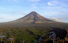
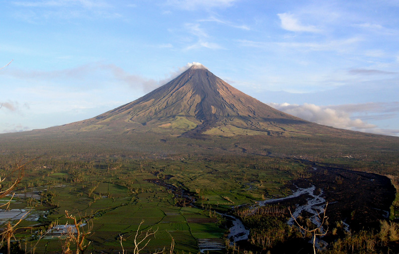
Mayon Volcano as viewed from Ligñon Hill in Legazpi City, Albay in December 2006Elevation 2,463 m (8,081 ft) [1] Prominence 2,447 m (8,028 ft) [1] Listing Ultra Location Map of the Philippines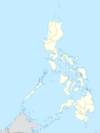
 Mayon Volcano
Location  Philippines
Coordinates 13°15′24″N 123°41′6″E / 13.25667°N 123.685°ECoordinates: 13°15′24″N 123°41′6″E / 13.25667°N 123.685°E Geology Type Stratovolcano Last eruption 2010[2] Mayon Volcano, also known as Mount Mayon, is an active volcano in the province of Albay, on the island of Luzon in the Philippines. Renowned as the "perfect cone" because of its almost symmetric conical shape, Mayon forms the northern boundary of Legazpi City, the largest city in terms of population in the Bicol Region. The mountain is a national park and a protected landscape in the country proclaimed as as Mayon Volcano Natural Park in the year 2000.[3]
Local folklore refers to the volcano as Bulkang Magayon (Bikol: 'Beautiful Volcano'), after the legendary heroine Daragang Magayon (Bikol: 'Beautiful Lady').[4]
Contents
Location
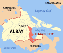 Mayon Volcano in Albay showing its distance from the Albay Gulf with Albay's capital city of Legazpi highlighted.
Mayon Volcano is the main landmark of Albay Province, Philippines, rising 2,462 metres (8,077 ft) from the shores of the Gulf of Albay about 10 kilometres (6.2 mi) away.[5][6] The volcano is geographically shared by the cities and municipalities of Legazpi City, Daraga, Camalig, Guinobatan, Ligao City, Tabaco City, Malilipot, and Santo Domingo (clockwise from Legazpi) which divide the cone like slices of a pie when viewed from above.
Geomorphology
Mayon is a classic stratovolcano type of volcano capped by a small central summit crater. The cone is considered to be the world's most perfectly-formed volcano for its symmetry,[6] which was formed through layers of pyroclastic and lava flows from past eruptions and erosion. The upper slopes of the basaltic-andesitic volcano are steep averaging 35-40 degrees.
Like other volcanoes located around Pacific Ocean, Mayon is part of the Pacific Ring of Fire. It is located on the eastern side of Luzon, near the Philippine Trench which is the convergent boundary where the Philippine Sea Plate is driven under the Philippine Mobile Belt. When a continental plate or belt of continental fragments meets an oceanic plate, the lighter continental material overrides the oceanic plate, forcing it down into the Earth's mantle. Magma may be forced through weaknesses in the continental crust caused by the collision of the tectonic plates. One such exit point is Mayon.
Recorded eruptions
Mayon is the most active volcano in the Philippines having erupted over 49 times in the past 400 years. The first record of a major eruption was witnessed in February 1616 by Dutch explorer Joris van Spilbergen who recorded it on his log in his circumnavigation trip around the world.[7]
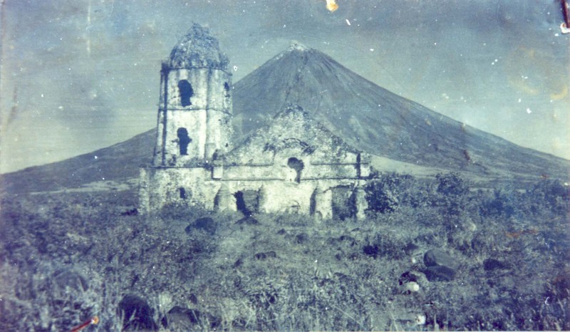
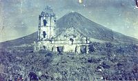 An old photograph of the Cagsawa ruins with the facade still standing. The church was largely destroyed during the 1814 eruption of Mayon.
The most destructive eruption of Mayon occurred on February 1, 1814. Lava flowed but not as much compared to the 1766 eruption. Instead, the volcano was belching dark ash and eventually bombarding the town with tephra that buried the town of Cagsawa. Trees were burned; rivers were certainly damaged. Proximate areas were also devastated by the eruption with ash accumulating to 9 m (30 ft) in depth. 2,200 Albay locals perished in what is considered to be the most lethal eruption in Mayon's history.[6] The eruption is believed to have contributed to the accumulation of atmospheric ash,[citation needed] capped off by the catastrophic eruption of Mount Tambora in 1815, that led to the Year Without a Summer in 1816.
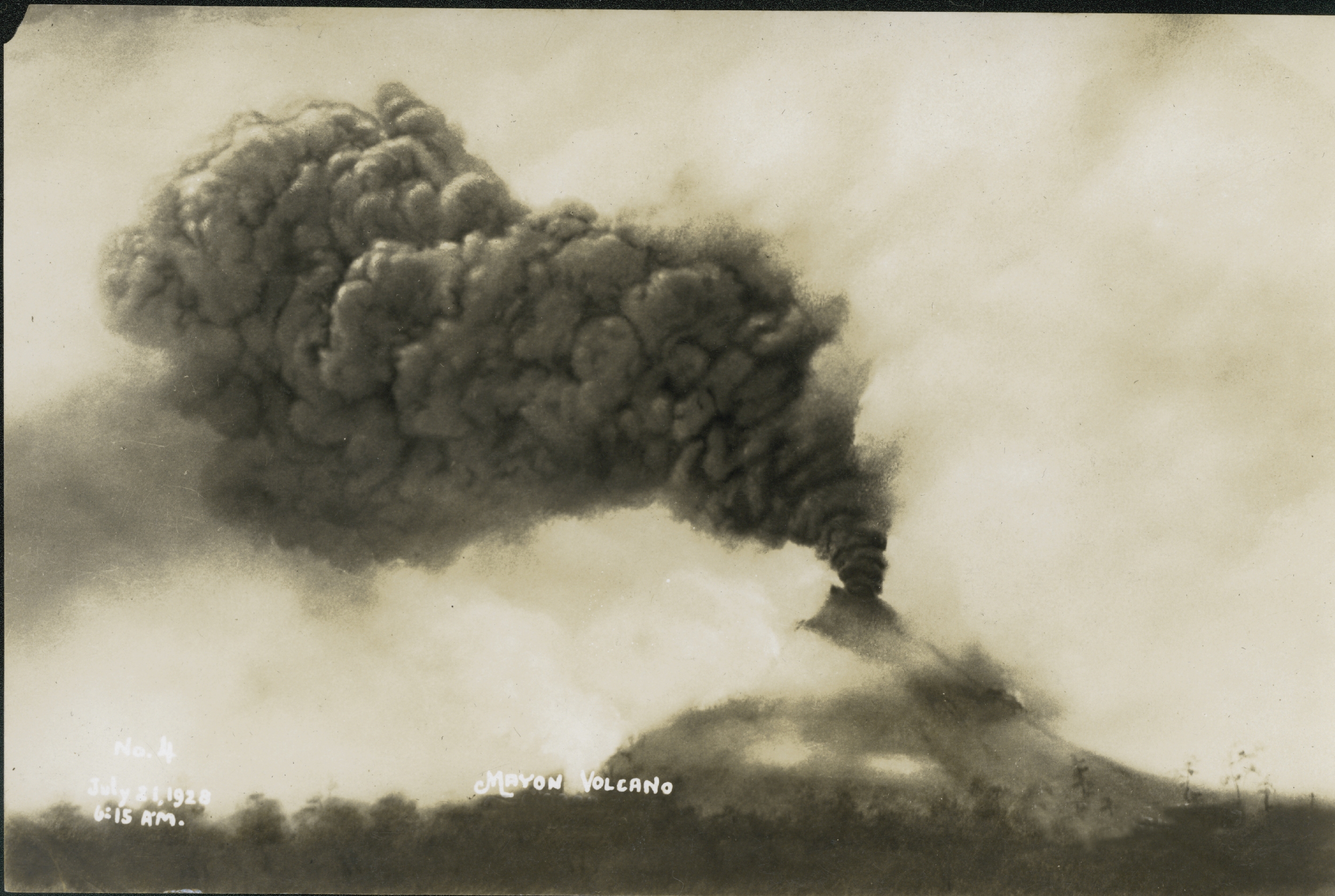
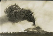 Mount Mayon in eruption on July 21, 1928.
Mayon Volcano's longest uninterrupted eruption occurred on June 23, 1897 which lasted for seven days of raining fire. Lava once again flowed down to civilization. Seven miles eastward, the village of Bacacay was buried 15 m (49 ft) beneath the lava. In Libon 100 people were declared dead—incinerated by steam and falling debris or hot rocks. Other villages like San Roque, Misericordia and Santo Niño became deathtraps. Ash was carried in black clouds as far as 160 km (100 mi) from the catastrophic event, which killed more than 400 people.[6]
Samuel Kneeland, a professor and a geologist had observed the volcanic activity five months before the eruption:
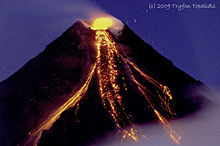
At night the scene was truly magnificent and unique. At the date of my visit the volcano had poured out...a stream of lava on the Legaspi side from the very summit. The viscid mass bubbled quietly but grandly, and overran the border of the crater, descending several hundred feet in a glowing wave, like red-hot iron. Gradually, fading as the upper surface cooled, it changed to a thousand sparkling rills among the crevices, and, as it passed beyond the line of complete vision behind the woods near the base, the fires twinkled like stars, or the scintillions of a dying conflagration. More than half of the mountain height was thus illuminated.[8]
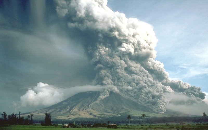
 Mayon Volcano on September 23, 1984
No casualties were recorded from the 1984 eruption after more than 73,000 people were evacuated from the danger zones as recommended by PHIVOLCS scientists.[9] But in 1993, pyroclastic flows killed 77 people, mainly farmers, during the eruption.
Its 48th and latest major eruption was a quiet effusion of lava on July 14, 2006,[10] which was aggravated when a lahar caused by the rains of Typhoon Durian followed on November 30, 2006. A further summit eruption occurred on August 10, 2008.[11] Starting in January 2011, the volcano is weakly erupting and may be building up to a larger hazardous eruption.
2006 eruption
Mayon erupted again from July to October 2006, with no apparent loss of life during the actual eruption period.
- July 18, 2006: The number and size of incandescent rockfalls from the active lava dome, as well as sulfur oxide emissions, increased, according to the Philippines Institute of Volcanology and Seismology (Phivolcs), which warned that pyroclastic flows or an explosive eruption could occur any time.
- August 7, 2006: The Philippine government ordered the evacuation of about 20,000 people living near the volcano, stating that an eruption was feared soon.[12] Volcanologists have detected 21 low-frequency volcanic earthquakes since early Sunday morning.[13]
- August 8, 2006: The government expected to move some 34,276 people to 31 state-run shelters and warned that the mountain could explode at any time.[14][15]
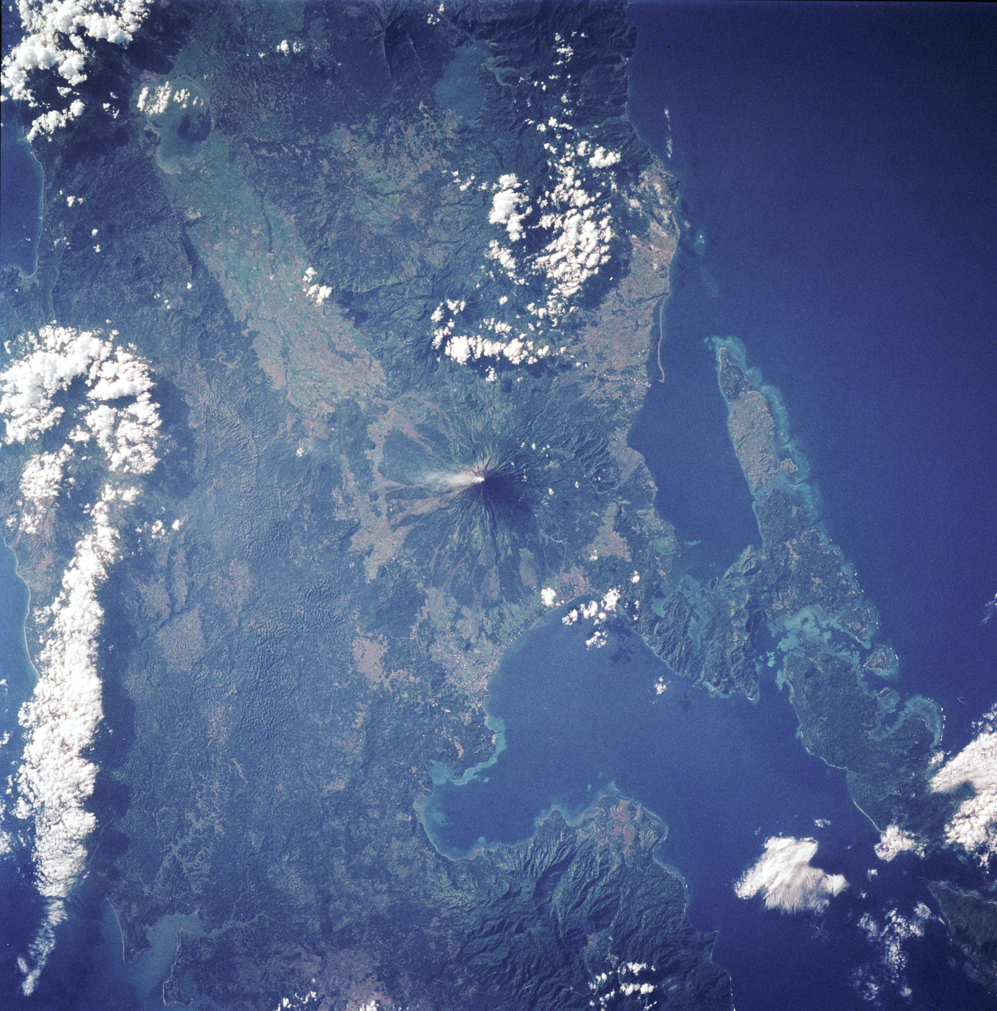
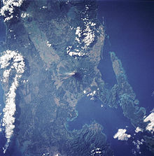 Mayon Volcano in satellite image.
- August 9, 2006: Volcanologists warned that Mount Mayon could explode at any time but that the gravitational pull of a full moon could provide the final push. A full moon coincided with at least three of Mayon’s nearly 50 explosions over the last four centuries, including the two most recent in 2000 and 2001. Nearly 40,000 people have been moved from an 8 km (5 mi) danger zone on the southeast flank of the volcano, which has been quaking and spitting plumes of ash since July.[16]
- August 10, 2006: Scientists in the Philippines renewed warnings of a major explosion at the Mount Mayon volcano, describing a sudden period of quiet as "ominous". A drop in gas emissions and earthquakes sparked fears that the crater had plugged itself, increasing the likelihood of an explosive eruption.[17]
- August 11, 2006: Scientists said ground surveys showed Mayon was still "swollen" and registered a high number of volcanic earthquakes, emitted large amounts of sulfur dioxide gas and continued to eject lava down its slope nearly four weeks after it came to life in a "quiet" eruption on July 14.[18]
Phivolcs maintained threat level at Alert Level 4 for the next month because of the continued extrusion of lava, ash explosions, steam and smoke plumes, seismic activity, and threat of further eruption.
- September 11, 2006 Phivolcs downgraded threat level to Alert Level 3. "After the ash explosion of September 1, a general decline in the overall activity of Mayon has been established. The decrease in key parameters such as seismicity, gas (Sulfur Dioxide) emission rates and ground inflation all indicate a waning condition. The slowdown in the eruptive activity is also evident from the decrease in intensity of crater glow and the diminishing volume of lava being extruded from the summit".[19]
- October 3, 2006 Phivolcs downgraded threat level to Alert Level 2. "All monitored key parameters such as earthquake levels, ground deformation and gas outputs further declined. In addition, lava extrusion apparently ceased on October 1, 2006 as reported by Ligñon Hill Observatory. The above observations indicate the absence of an intruding new mass of magma." [20]
- October 25, 2006 Phivolcs downgraded threat level to Alert Level 1 (no hazardous eruption imminent).[21]
Phivolcs did not issue any further alerts or updates for Mayon in November or December 2006.
Aftermath
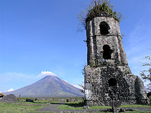 The church tower is what remains of the Cagsawa Church, which was buried by the 1814 eruption of Mayon Volcano. It withstood the damage done by Typhoon Durian in 2006.
On November 30, 2006, Typhoon Durian caused mudslides of volcanic ash and boulders from the slopes of Mayon Volcano, killing an estimated 1,000 and covering a large portion of the village of Padang (an outer suburb of Legazpi City) in mud up to the houses' roofs.[22][23]
The number of dead was at least 1,266 people, about half the death toll of the 1814 eruption. The precise figure may never be known since many people were buried under the lahars, and entire villages disappeared. A similar post-eruption event happened in Cagsawa in 1825 where 1,500 people were killed.[4]
Parts of Daraga were also devastated, including the Cagsawa area, where the ruins from the eruption of 1814 were partially buried once again. Large areas of Guinobatan were destroyed, particularly Maipon.
Students from Aquinas University in Barangay Rawis of Legazpi City were among those killed as mudslides engulfed their dormitory. Central Legazpi escaped the mudslide but suffered from severe flooding and power cuts.
2008 eruption
On August 10, 2008, a summit explosion ejected ash 200 metres above the summit, with the ash drifting east northeast. In the weeks prior to the eruption,[24] there was a visible glow within the crater and increased seismicity.[11]
2009-2010 eruption
On 10 July 2009, PHIVOLCS raised the status from Alert Level 1 (low level unrest) to Alert Level 2 (moderate unrest) because the number of recorded low frequency volcanic earthquakes rose to the same level when a phreatic explosion occurred last August 2008.[25][26]
At 5:32 am Wednesday 28 October 2009, a minor ash explosion lasting for about one minute occurred in the summit crater. A brown ash column rose about 600 meters above the crater and drifted toward the northeast. In the prior 24 hours, 13 volcanic earthquakes were recorded. Steam emission was at moderate level, creeping downslope toward the southwest. Phivolcs maintained the Alert Status at Level 2, but later warned that with the approach of tropical cyclone international codename Mirinae the danger of lahars and possible crater wall collapse will greatly increase and all specified precautions should be taken.[27]
At 1:58 am Wednesday 11 November 2009, a minor ash explosion occurred at the summit crater lasting for about three minutes. This was recorded by the seismic network as an explosion type earthquake with rumbling sounds. Incandescent rock fragments at the upper slope were observed in nearby barangays. Ash column was not observed because of cloud cover. After dawn, field investigation showed ashfall had drifted southwest of the volcano. In the 24 hour period, the seismic network recorded 20 volcanic earthquakes. Alert Status was kept at Level 2 indicating the current state of unrest could lead to more ash explosion or eventually to hazardous magmatic eruption.[28]
At 8pm on Monday 14 December 2009, as a result of 83 volcanic quakes in the preceding 24 hours[29] and increased sulphur dioxide emissions, Phivolcs raised the Alert status to Level 3.[30]
Early in the morning of Tuesday 15 December 2009, a moderate ash explosion occurred at the summit crater and "quiet extrusion of lava" resulted in flows down to about 500 metres from the summit of Mayon.[31] By Tuesday night Albay Province authorities were reported to have moved about 20,000 residents out of the eight kilometre danger zone and into local evacuation centres. About 50,000 people were said to live within the eight kilometre zone.[32][33]
On 17 December 2009, there were five ash ejections with one reaching 500 metres above the summit, sulphur dioxide emission increased to 2,758 tonnes per 24 hours, lava flows reached down to 1500 metres below the summit, and incandescent fragments from the lava pile continuously rolling down Bonga Gully reached a distance of 3 to 4 km below the summit. By midday 17 December, a total of 33,833 people from 7,103 families had been evacuated, 72 percent of the total number of people that needed to be evacuated, Albay Governor Joey Salceda was reported to have said.[34]
On December 20, 2009, PHIVOLCS raised Mayon's status level to alert level 4 because of an increasing lava flow in the southern portion of the volcano and an increase in sulphur dioxide emission to 750 tonnes per day. As well, almost 460 earthquakes in the volcano were monitored everyday. In the border of danger zone, rumbling sounds like thunder were also heard. Over 9,000 families (44,394 people) were evacuated by the Philippine government from the base of the volcano.[35] No civilian was permitted within the 8 kilometre danger zone, which has been cordoned off by the Philippine military, who were actively patrolling within the danger zone to enforce the "no-go" rule and to ensure no damage or loss of property of those evacuated.[36]
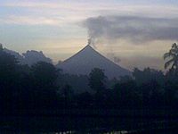
 Mayon Volcano in eruption on December 29, 2009.
Alert level 4 was maintained as the volcano remained restive through the month of December, prompting affected residents to spend Christmas and the New Year in evacuation centers.[37] On December 25, sulfur dioxide emissions peaked at 8,993 tons per day.[38][39] On December 28, PHIVOLCS director Renato Solidum commented on the status of the volcano, "You might think it is taking a break but the volcano is still swelling."[36] On the next day December 29, a civil aviation warning for the airspace near the summit was included in the volcano bulletins.[40] The ejected volcanic material since the start of the eruption was estimated to have been between 20 million to 23 million cubic meters of rocks and volcanic debris, compared to 50 million to 60 million cubic meters in past eruptions.[41]
On January 2, 2010, PHIVOLCS lowered the alert level of the volcano from level 4 to level 3, citing decreasing activity observed in the past four days.[42] The state agency noted the following observations as a trend of decreasing activity: absence of ash ejections and relative weakness of steam emissions, majority of earthquakes caused by rockfalls and rolling fragments, and gradual decrease in sulfur dioxide emissions from a maximum of 8,993 tons per day to 2,621 tons per day.[39] 7,218 families within the seven-kilometer to eight-kilometer danger zones were allowed to return to their homes, while 2,728 families who live in the four-kilometer to six-kilometer danger zones would have to stay in the evacuation centers pending the PHIVOLCS decision to further lower the alert level.[43]
On January 13, 2010, PHIVOLCS reduced the alert level from 3 to 2, saying that this indicated a further reduction in the likelihood of hazardous eruption.[44]
Government response
 Map showing major volcanoes of the Philippines
Albay governor Joey Salceda declared the disaster zone an 'open city' area to encourage aid from external groups. Potential donors of relief goods were not required to secure clearance from the Provincial Disaster Coordinating Council, but were able to directly coordinate with support groups at the local government level.[45]
The restiveness of the volcano also stimulated the tourism industry of the province. Up to 2,400 tourists per day have arrived in the area since the volcano started erupting on December 14, filling local hotels, compared to about a more modest average of 200 in the days prior. However it was reported that some tourists lured by local "guides" might be ignoring government warnings not to venture into the eight-kilometer danger zone. "It's a big problem. I think the first violation of the zero casualty (record) will be a dead tourist," said Salceda.[46]
Speaking about thrill-seekers finding their way in to the area, Salceda warned, "At the moment of the eruption, the local guides will have better chance of getting out. The hapless tourist will be left behind."[46]
International response
Following the declaration of alert level 3 for the volcano, the United States issued an advisory cautioning its nationals from traveling to Mayon. Canada and the United Kingdom also posted advisories discouraging their nationals from visiting the volcano.[47]
The United States government has committed $100,000 in financial aid for the evacuees of Mayon Volcano. In cooperation with the Philippine government the assistance will be delivered through the Philippine National Red Cross and other NGOs by USAID.[48]
The Albay provincial government has ordered the local military to add more checkpoints, place roadblocks and arrest tourists caught traveling inside the eight-kilometer danger zone.[49]
Power and water supply were cut off within the danger zone to further discourage residents from returning. The Commission on Human Rights has allowed the use of emergency measures and has given the authorities clearance to forcibly evacuate residents who refuse to leave.[50]
When the alert level around the volcano was lowered from alert level 4 to alert level 3 on January 2, 2010, the Albay provincial government ordered a decampment of some 47,000 displaced residents from the evacuation centers.[51] Power and water supply in the danger zones were restored.[37] Military vehicles were used to transport the evacuees back to their homes, while food supplies and temporary employment through the Department of Social Welfare and Development (DSWD) were provided to the heads of each family.[51][52] As of January 3, 2010, the National Disaster Coordinating Council reported the overall cost of humanitarian aid and other assistance provided by the government and non-government organizations (NGOs) has reached over 61 million pesos since the start of the eruption.[53]
The United Nations World Food Programme (UN-WFP) has delivered 20 tons of high energy biscuits to the evacuees to complement supplies provided by the DSWD, with more to be allocated from emergency food stocks intended for relief from the effects of the 2009 Pacific typhoon season.[54] When the alert level was downgraded to level 3 on January 2, 2010, UN-WFP provided three days worth of food for evacuees returning to their homes who will continue to receive supplies already set aside for them.[42]
Monitoring
Mayon Volcano is the most active volcano in the Philippines, and its activity is regularly monitored by PHIVOLCS from their provincial headquarters on Ligñon Hill, about 10 kilometers away from the summit.
Three telemetric units are installed on Mayon's slopes, which send information to the seven seismometers in different locations around the volcano. These instruments relay data to the Ligñon Hill observatory and the PHIVOLCS central headquarters on the University of the Philippines Diliman campus.
PHIVOLCS also deploys electronic distance meters (EDMs), precise leveling benchmarks, and portable fly spectrometers to monitor the volcano's daily activity.[55][56]
See also
- Cagsawa Ruins
- List of mountains in the Philippines
- List of Southeast Asian mountains
- List of volcanic eruptions by death toll
- List of volcanoes in the Philippines
 Media related to Mayon Volcano at Wikimedia Commons
References
- ^ a b de Ferranti, Jonathan; Aaron Maizlish. "Philippine Mountains - 29 Mountain Summits with Prominence of 1,500 meters or greater". http://www.peaklist.org/WWlists/ultras/philippines.html. Retrieved 2011-01-31.
- ^ Mayon, Global Volcanism program, Smithsonian Institution.
- ^ "Protected Areas in Region 5". Protected Areas and Wildlife Bureau. Retrieved on 2011-10-15.
- ^ a b England, Vaudine (2009-12-24). "Mount Mayon: a tale of love and destruction". BBC News. http://news.bbc.co.uk/2/hi/asia-pacific/8427922.stm. Retrieved 2009-12-25.
- ^ "Mayon Volcano, Philippines". Philippines Department of Tourism. Volcano.und.edu. Archived from the original on 2007-10-12. http://web.archive.org/web/20071012025231/http://volcano.und.edu/vwdocs/current_volcs/philippines/mayonvol.html. Retrieved 2007-11-20.
- ^ a b c d Davis, Lee (1992). Natural disasters: from the Black Plague to the eruption of Mt. Pinatubo. New York, NY: Facts on File Inc.. pp. 300–301.
- ^ Bankoff, Greg (2003). "Culture of disasters: society and natural hazards in the Philippines", pg. 39. RoutlegeCurzon, New York. ISBN 0-203-22189-3.
- ^ Samuel Kneeland (1888). Volcanoes and earthquakes. D. Lothrop Co.. p. 116. http://books.google.com/books?id=hqMOAAAAYAAJ&pg=PA116.
- ^ "USGS". http://volcanoes.usgs.gov/Imgs/Jpg/Mayon/-020_caption.html. Retrieved 2008-06-25.[dead link]
- ^ "Mayon Volcano". Philippine Institute of Volcanology and Seismology. http://volcano.phivolcs.dost.gov.ph/update_VMEPD/Volcano/VolcanoList/mayon.htm. Retrieved 2009-12-14.
- ^ a b "Mayon Volcano Advisory". Philippine Institute of Volcanology and Seismology. 2008-08-10. http://www.phivolcs.dost.gov.ph/index.php?option=com_content&task=view&id=68&Itemid=26. Retrieved 2009-12-24.
- ^ "Philippine volcano 'set to erupt'". BBC. 2006-08-10. http://news.bbc.co.uk/2/hi/asia-pacific/4778883.stm. Retrieved 2008-06-25.
- ^ "Photo in the News: Philippine Volcano Threatens Eruption". National Geographic. http://news.nationalgeographic.com/news/2006/08/-volcano.html. Retrieved 2008-06-25.[dead link]
- ^ Manila Standard: 34,000 flee Mayon area; Manila Bulletin: Mayon volcano records 3 additional ash explosions
- ^ Mayon volcano's lava lights up the clouds near Legazpi City
- ^ "Full moon fear for Mayon volcano". BBC News. March 2009. http://news.bbc.co.uk/2/hi/asia-pacific/5258806.stm. Retrieved 2008-08-29.
- ^ 'Ominous quiet' at Mayon volcano BBC News.
- ^ Relief goods arrive amid wait for Mayon’s big bang(archived from the original on 2007-03-11) Associated Press
- ^ "Mayon Volcano Bulletin 09/11/2006". http://www.phivolcs.dost.gov.ph/update_VMEPD/news/mayon091106_5pm-lower3.html. Retrieved 2008-08-06.[dead link]
- ^ "Mayon Volcano Bulletin 10/03/2006". http://www.phivolcs.dost.gov.ph/update_VMEPD/news/mayon100306_4pm.html. Retrieved 2008-05-06.[dead link]
- ^ "Mayon Volcano Bulletin 10/25/2006". Archived from the original on 2008-04-20. http://web.archive.org/web/20080420213750/http://www.phivolcs.dost.gov.ph/update_VMEPD/news/mayon102506_AL1.html. Retrieved 2008-05-06.
- ^ It also created volcanic rock.Typhoon sends red-hot boulders into villages - CNN.com (archived from the original on 2008-01-25).
- ^ "Yahoo! News". http://news.yahoo.com/s/ap//ap_on_re_as/asia_storm. Retrieved 2008-06-25.[dead link]
- ^ "Global Volcanism Program - Mayon - Summary". Smithsonian National Museum of Natural History. http://www.volcano.si.edu/world/volcano.cfm?vnum=0703-03=. Retrieved 2009-12-24.
- ^ "Mayon Volcano Bulletin". Philippine Institute of Volcanology and Seismology (via Google cache). 2009-07-10. http://74.125.153.132/search?q=cache:4hTacnvPhJ8J:www.phivolcs.dost.gov.ph/index.php%3Foption%3Dcom_content%26task%3Dview%26id%3D188%26Itemid%3D1. Retrieved 2009-12-31.
- ^ "Mayon in 'state of unrest,' alert level raised". ABS-CBN News. 2009-07-10. http://www.abs-cbnnews.com/nation/regions/07/10/09/mayon-state-unrest-alert-level-raised. Retrieved 2010-01-01.
- ^ "Mayon spews ash anew". Volcano Monitor. Philippine Daily Inquirer. October 28, 2009. http://inquirer.net/specialreports/volcanomonitor/view.php?db=1&article=20091028-232734. Retrieved 2009-12-05.
- ^ "Mayon Volcano Advisory (November 2009)". Philippine Institute of Volcanology and Seismology. 2009-11-11. http://www.phivolcs.dost.gov.ph/index.php?option=com_content&task=view&id=224&Itemid=1. Retrieved 2009-12-11.
- ^ Papa, Alcuin (2009-12-15). "6-7 km from Mayon volcano off limits to people". Philippine Daily Inquirer. http://inquirer.net/specialreports/volcanomonitor/view.php?db=1&article=20091215-242177. Retrieved 2009-12-15.
- ^ "Lava flows from Mayon Volcano". ABS-CBN News. 2009-12-15. http://www.abs-cbnnews.com/nation/regions/12/14/09/lava-flows-mayon-volcano. Retrieved 2009-12-24.
- ^ "Mayon Volcano Bulletin 3". Philippine Institute of Volcanology and Seismology. 2009-12-16. http://www.phivolcs.dost.gov.ph/index.php?option=com_content&task=view&id=255&Itemid=1. Retrieved 2009-12-16.[dead link]
- ^ Gomez, Jim (2009-12-15). "20,000 evacuated as Philippine volcano oozes lava". Yahoo News. http://news.yahoo.com/s/ap/20091215/ap_on_re_as/as_philippines_volcano. Retrieved 2009-12-15.[dead link]
- ^ "Residents flee as Philippines volcano threatens to erupt". CNN World. 2009-12-15. http://www.cnn.com/2009/WORLD/asiapcf/12/15/philippines.volcano.mayon/index.html. Retrieved 2009-12-24.
- ^ "Volcano Monitor - PHIVOLCS warns: Mayon to blow its top in a few weeks". Philippine Daily Inquirer. 2009-12-18. http://inquirer.net/specialreports/volcanomonitor/view.php?db=1&article=20091218-242651. Retrieved 2009-12-18.
- ^ "Volcano spews lava as eruption looms". CNN World. 2009-12-22. http://www.cnn.com/2009/WORLD/asiapcf/12/22/volcano.philippines/index.html. Retrieved 2009-12-24.
- ^ a b "Inquirer Volcano Monitor 2009-12-27". Philippine Daily Inquirer. 2009-12-27. http://inquirer.net/specialreports/volcanomonitor/view.php?db=1&article=20091227-244179. Retrieved 2009-12-27.
- ^ a b Papa, Alcuin and Nasol, Rey M. (2010-01-01). "Mayon quieting down". Philippine Daily Inquirer. http://newsinfo.inquirer.net/inquirerheadlines/nation/view/20100101-245096/Mayon-quieting-down. Retrieved 2010-01-02.
- ^ "Mayon Volcano Bulletin 13". Philippine Institute of Volcanology and Seismology. 2009-12-26. http://www.phivolcs.dost.gov.ph/index.php?option=com_content&task=view&id=275&Itemid=1. Retrieved 2009-12-26.[dead link]
- ^ a b "Mayon Volcano Bulletin 20". Philippine Institute of Volcanology and Seismology. 2010-01-02. http://www.phivolcs.dost.gov.ph/index.php?option=com_content&task=view&id=282&Itemid=1. Retrieved 2010-01-02.[dead link]
- ^ "Mayon Volcano Bulletin 16". Philippine Institute of Volcanology and Seismology. 2009-12-29. http://www.phivolcs.dost.gov.ph/index.php?option=com_content&task=view&id=278&Itemid=1. Retrieved 2009-12-29.[dead link]
- ^ Flores, Helen (2010-01-02). "Phivolcs may lower Mayon alert level". The Philippine Star. http://www.philstar.com/Article.aspx?articleId=537448&publicationSubCategoryId=63. Retrieved 2010-01-02.
- ^ a b "Philippine volcano calming; thousands head home". The Associated Press (via Yahoo! News). 2010-01-01. http://news.yahoo.com/s/ap/20100102/ap_on_re_as/as_philippines_volcano. Retrieved 2010-01-02.[dead link]
- ^ "Alert level around Mayon lowered to 3". GMA News.TV. 2010-01-02. http://www.abs-cbnnews.com/nation/01/02/10/alert-level-around-mayon-lowered-3. Retrieved 2010-01-02.
- ^ "Mayon Volcano Bulletin 31". Philippine Institute of Volcanology and Seismology. 2010-01-13. http://www.phivolcs.dost.gov.ph/index.php?option=com_content&task=view&id=296&Itemid=1. Retrieved 2010-01-13.[dead link]
- ^ MA Loterte (2009-12-28). "PGMA visits Mayon evacuees, assures government aid". Philippine Information Agency. http://www.pia.gov.ph/?m=12&fi=p091228.htm&no=09. Retrieved 2009-12-30.
- ^ a b "Thrill-seeking tourists flock to Philippine volcano". Agence France-Presse. 2009-12-30. http://www.google.com/hostednews/afp/article/ALeqM5hDXDD6v4U3OyvNWX4Mnw7ewcnVcA. Retrieved 2009-12-30.
- ^ "UK, Canada to nationals: Stay away from Mayon Volcano". GMA News.TV. 2009-12-19. http://www.gmanews.tv/story/179758/uk-canada-to-nationals-stay-away-from-mayon-volcano. Retrieved 2010-01-02.
- ^ Zhang Xiang (2009-12-30). "U.S. provides financial aid to Mayon Volcano evacuees". Xinhua News Agency. http://news.xinhuanet.com/english/2009-12/30/content_12729792.htm. Retrieved 2009-12-30.
- ^ "Authorities want 'hardheaded' Mayon tourists arrested". GMA News.TV. 2009-12-28. http://www.gmanews.tv/story/180337/authorities-want-hardheaded-mayon-tourists-arrested. Retrieved 2009-12-30.
- ^ Dedace, Sophia Regine (2009-12-31). "Albay govt to cut power in Mayon danger zones". GMA News.TV. http://www.gmanews.tv/story/180542/albay-govt-to-cut-power-in-mayon-danger-zones. Retrieved 2009-12-31.
- ^ a b Recuenco, Aaron B. (2010-01-02). "Worst is over at Mayon". Manila Bulletin. http://www.mb.com.ph/articles/236658/worst-over-mayon. Retrieved 2010-01-02.
- ^ Jerusalem, Evelyn E.. "Mayon evacuees avails of the cash for work project". Department of Social Welfare and Development (Philippines). http://www.fo5.dswd.gov.ph/articledetails.php?id=207. Retrieved 2010-01-02.[dead link]
- ^ Rabonza, Glenn J. (2010-01-03). "NDCC Update Sitrep No. 22 re Mayon Volcano" (PDF). National Disaster Coordinating Council. http://210.185.184.53/ndccWeb/images/ndccWeb/ndcc_update/Mt_Mayon/JANUARY_2010/ndcc%20update%20sitrep%20no.%2022%20re%20mayon%20volcano%20as%20of%2003%20jan%202010%2C%207am.pdf. Retrieved 2010-01-03.
- ^ "UN-WFP sends food aid for Mayon Volcano evacuees". Philippine Information Agency. 2009-12-29. http://www.pia.gov.ph/?m=12&fi=p091229.htm&no=18. Retrieved 2010-01-01.
- ^ Nasol, Rey M. (2009-12-27). "Mayon instruments intact despite eruption". Philippine Daily Inquirer. http://newsinfo.inquirer.net/inquirerheadlines/regions/view/20091227-244111/Mayon-instruments-intact-despite-eruption. Retrieved 2009-12-30.
- ^ Dedace, Sophia R. (2009-12-30). "Mayon watch: An inside look at the Phivolcs headquarters". GMA News.TV. http://www.gmanews.tv/story/180529/mayon-watch-an-inside-look-at-the-phivolcs-headquarters. Retrieved 2009-12-30.
External links
- Philippines National Disaster Coordinating Council - Mayon updates
- Climbing Mayon Volcano
- Philippine Institute of Volcanology and Seismology (PHIVOLCS) Mayon Volcano Page
- PHIVOLCS LHO (Lignon Hill Observatory)
- NASA Earth Observatory page
- Majestic Mt. Mayon - Cagsawa Ruin Park – images by Jenny Exconde.
- Smithsonian Global Volcanism Program - Mayon
- Mayon Volcano Natural Park
- Mayon Volcano – Philippines Travel Guide.
Categories:- Stratovolcanoes
- Subduction volcanoes
- Volcanoes of Luzon
- Mountains of the Philippines
- Albay
- Active volcanoes of the Philippines
- National parks of the Philippines


Wikimedia Foundation. 2010.