- National Register of Historic Places listings in New Castle County, Delaware
-
This is a list of the National Register of Historic Places listings in New Castle County, Delaware.
This is intended to be a complete list of the properties and districts on National Register of Historic Places in the New Castle County, Delaware, excluding the city of Wilmington and sites that use a Wilmington address. The locations of National Register properties and districts for which the latitude and longitude coordinates are included below, may be seen in a map.[1]
There are 378 properties and districts listed on the National Register in the county. Two hundred sixty-seven are outside of Wilmington and are listed here. One hundred-eleven are in Wilmington, and are in the accompanying list-article National Register of Historic Places listings in Wilmington, Delaware. Five sites, excluding ones in Wilmington, are further designated as National Historic Landmarks.
-
- This National Park Service list is complete through NPS recent listings posted November 10, 2011.[2]
Contents: Counties in Delaware
Kent - New Castle - Sussex Contents
Current listings
Wilmington
Outside of Wilmington
Landmark name Image Date listed Location City or Town Summary 1 Academy of Newark May 24, 1976 Main and Academy Sts.
39°40′58″N 75°44′58″W / 39.68278°N 75.74944°WNewark 2 Achmester December 28, 1979 North of Middletown on County Road 429
39°29′2″N 75°42′27″W / 39.48389°N 75.7075°WMiddletown 3 Aetna Hose, Hook and Ladder Company Fire Station No. 1 
May 7, 1982 26 Academy St.
39°40′55″N 75°44′58″W / 39.68194°N 75.74944°WNewark 4 Aetna Hose, Hook and Ladder Company, Fire Station No. 2 
May 7, 1982 31 Academy St.
39°40′55″N 75°44′59″W / 39.68194°N 75.74972°WNewark 5 Aiken's Tavern Historic District 
December 6, 1977 Junction of U.S. Route 40 and Delaware Route 896
39°36′23″N 75°44′45″W / 39.60639°N 75.74583°WNewark 6 Air Service, Inc. Hangar at Bellanca Airfield June 15, 2005 Delaware Route 273 and Center Point Blvd
39°39′52.58″N 75°35′15.38″W / 39.6646056°N 75.5876056°WNew Castle 7 Charles Allen House August 19, 1983 855 Canoe Rd.
39°38′46″N 75°40′40″W / 39.64611°N 75.67778°WChristiana 8 Amstel House 
May 12, 1977 Delaware and 4th Sts.
39°39′38″N 75°33′55″W / 39.66056°N 75.56528°WNew Castle 9 Anderson House 
February 24, 1983 50 W. Park Pl.
39°40′30″N 75°45′24″W / 39.675°N 75.75667°WNewark 10 Appoquinimink Friends Meetinghouse December 4, 1972 Main St.
39°27′24″N 75°39′55″W / 39.45667°N 75.66528°WOdessa 11 Archmere 
September 9, 1992 3600 Philadelphia Pike
39°48′4″N 75°27′16″W / 39.80111°N 75.45444°WClaymont 12 Ardens Historic District 
May 30, 2003 Orleans Rd. at Harvey Rd.
39°48′41″N 75°29′16″W / 39.81139°N 75.48778°WArden 13 Armstrong Lodge No. 26, A.F. & A.M. 
July 14, 1993 112-114 E. Market St. in Christiana Hundred
39°42′49″N 75°36′31″W / 39.71361°N 75.60861°WNewport 14 A. Armstrong Farm November 13, 1986 Old Wilmington Rd. W of Brackenville Rd.
39°47′11″N 75°40′28″W / 39.78639°N 75.67444°WNewark 15 Armstrong-Walker House September 13, 1985 Delaware Route 71
39°28′47″N 75°43′17″W / 39.47972°N 75.72139°WMiddletown 16 Ashland Bridge 
March 20, 1973 South of Ashland over Red Clay Creek
39°47′53″N 75°39′29″W / 39.79806°N 75.65806°WAshland 17 Ashton Historic District November 15, 1978 North of Port Penn on Thormton Rd.
39°31′52″N 75°35′3″W / 39.53111°N 75.58417°WPort Penn 18 Auburn Mills Historic District January 22, 1980 West of Yorklyn on Delaware Route 82 and County Road 253
39°48′28″N 75°40′49″W / 39.80778°N 75.68028°WYorklyn 19 Augustine Beach Hotel April 3, 1973 South of Port Penn on Delaware Route 9
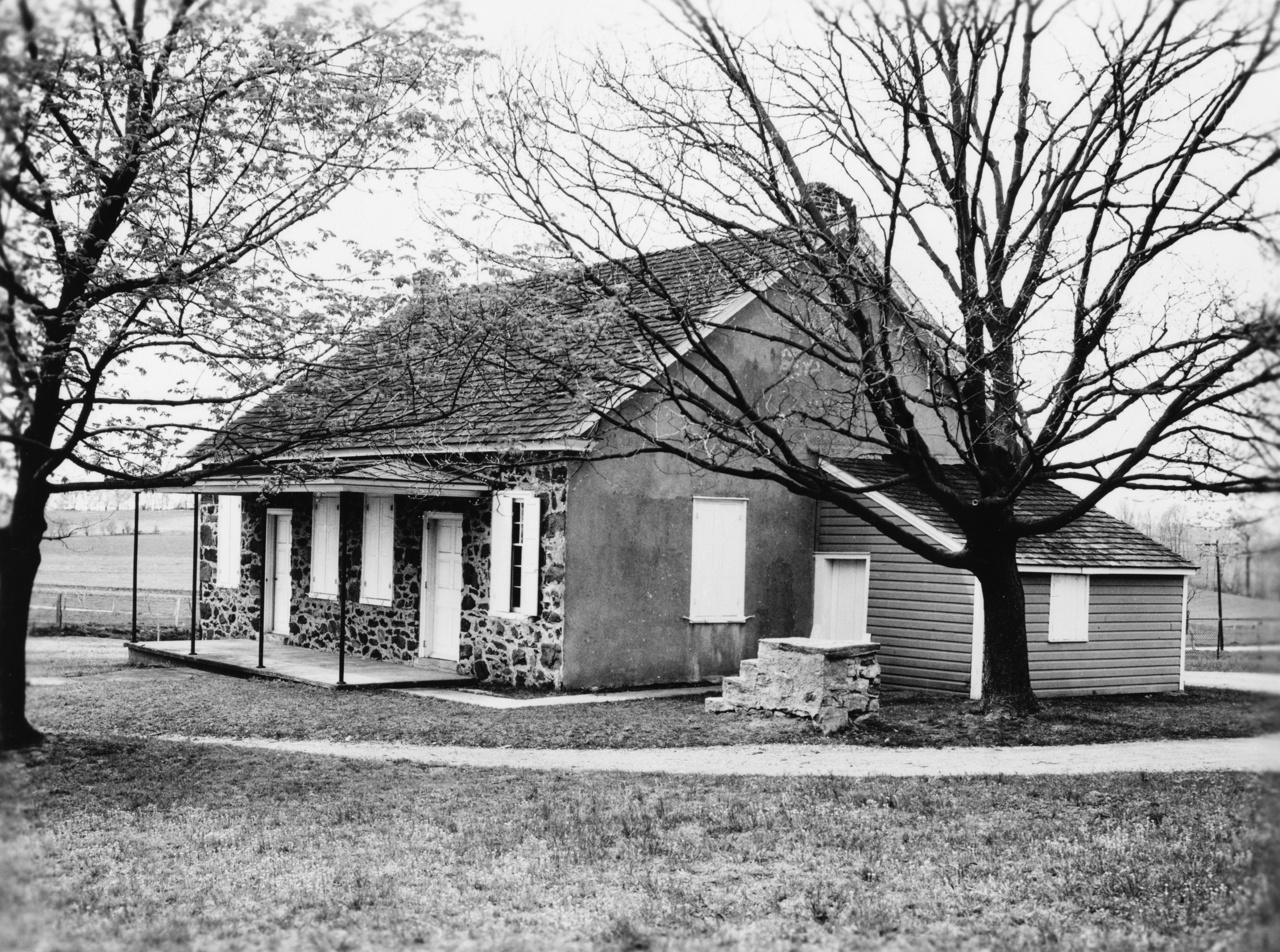
39°30′27″N 75°34′47″W / 39.5075°N 75.57972°WPort Penn 20 Baily House 
May 7, 1982 166 W. Main St.
39°41′3″N 75°45′33″W / 39.68417°N 75.75917°WNewark 21 Bank of Newark Building 
February 24, 1983 102 E. Main St.
39°41′22″N 75°45′58″W / 39.68944°N 75.76611°WNewark 22 Bartley-Tweed Farm November 13, 1986 Foxden Rd. east of Polly Drummond Rd.
39°43′13″N 75°42′59″W / 39.72028°N 75.71639°WNewark 23 Duncan Beard Site December 18, 1973 Address Restricted Odessa 24 Bell Farmhouse 
February 24, 1983 401 Nottingham Rd.
39°41′15″N 75°46′13″W / 39.6875°N 75.77028°WNewark 25 Belleview September 13, 1985 County Road 428
39°29′34″N 75°39′53″W / 39.49278°N 75.66472°WMiddletown 26 Belmont Hall 
February 24, 1983 302 W. Main St.
39°41′3″N 75°45′41″W / 39.68417°N 75.76139°WNewark 27 Biddle House December 8, 1978 Biddles Corner on U.S. Route 13
39°31′25″N 75°38′52″W / 39.52361°N 75.64778°WPort Penn 28 Gov. Benjamin T. Biggs Farm September 11, 1987 County Road 435, Choptank Rd.
39°30′54″N 75°44′46″W / 39.515°N 75.74611°WMiddletown 29 Bloomfield April 8, 1982 U.S. Route 13
39°33′20″N 75°39′24″W / 39.55556°N 75.65667°WSt. Georges 30 Blue Hen Farm 
February 24, 1983 505 Stamford Dr.
39°41′45″N 75°46′0″W / 39.69583°N 75.766667°WNewark 31 Brook Ramble September 11, 1992 Junction of County Roads 458 and 459 in Appoquinimink Hundred
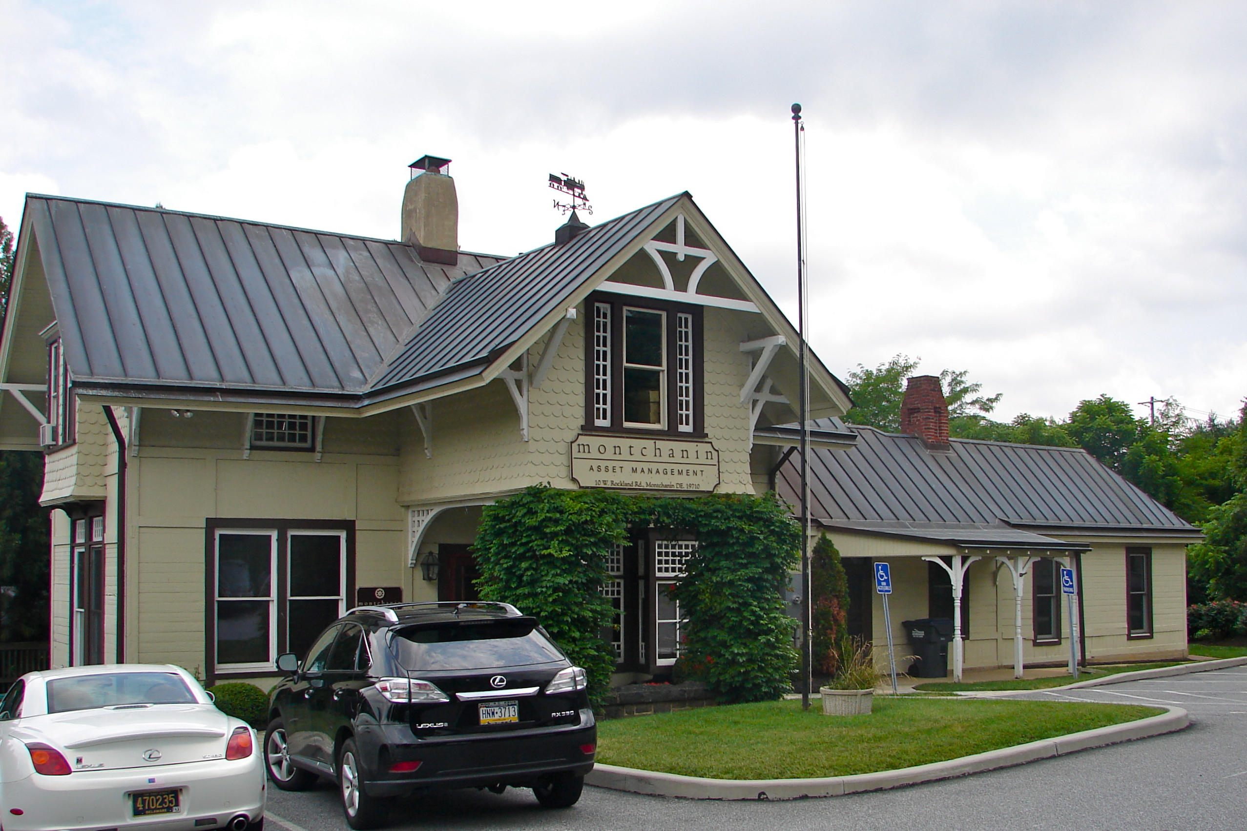
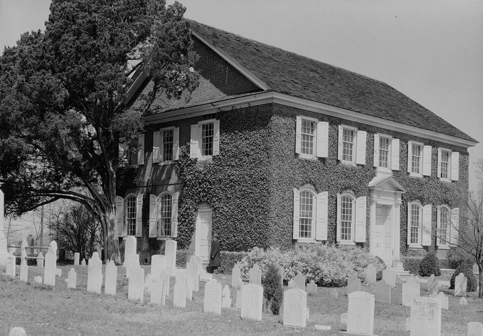
39°24′7″N 75°43′59″W / 39.40194°N 75.73306°WTownsend 32 Jacob Broom House 
December 2, 1974 1 mile northwest of Wilmington
39°47′10″N 75°39′44″W / 39.78611°N 75.66222°WMontchanin 33 Buena Vista April 16, 1971 661 South DuPont Highway
39°38′6″N 75°38′14″W / 39.635°N 75.63722°WNew Castle 34 Building at 28-34½ Academy Street 
May 7, 1982 28-34½ Academy St.
39°41′0″N 75°45′0″W / 39.683333°N 75.75°WNewark 35 Building at 140 W. Main Street 
May 7, 1982 140 Main St.
39°41′2″N 75°45′29″W / 39.68389°N 75.75806°WNewark 36 Building at 34 Choate Street 
February 24, 1983 34 Choate St.
39°41′9″N 75°44′56″W / 39.68583°N 75.74889°WNewark 37 John Carney Agricultural Complex February 25, 2009 4300 Thompson Bridge Road Greenville 38 Carpenter-Lippincott House 
April 13, 1983 5620 Kennett Pike
39°49′5″N 75°37′1″W / 39.81806°N 75.61694°WCentreville 39 W. Casperson House April 8, 1982 Kirkwood Rd.
39°35′27″N 75°40′36″W / 39.59083°N 75.67667°WSt. Georges 40 Centre Meeting and Schoolhouse 
December 16, 1971 Center Meeting Rd.
39°49′8″N 75°36′0″W / 39.81889°N 75.6°WCentreville 41 Centreville Historic District 
April 13, 1983 Kennett Pike and Owls Nest/Twaddell Mill Rd.
39°49′16″N 75°37′0″W / 39.82111°N 75.616667°WCentreville 42 Chambers House (Hopkins Bridge Road) November 29, 1988 Creek and Hopkins Bridge Rds.
39°43′38″N 75°46′6″W / 39.72722°N 75.76833°WNewark Note that there is one other Chambers House in the Newark area 43 Chambers House (College Avenue) February 24, 1983 S. College Ave.
39°40′41″N 75°45′15″W / 39.67806°N 75.75417°WNewark Note that there is one other Chambers House in the Newark area 44 Joseph Chandler House 
April 13, 1983 5826 Kennett Pike
39°49′26″N 75°37′9″W / 39.82389°N 75.61917°WCentreville 45 Chelsea April 8, 1982 Delaware Route 9
39°34′38″N 75°35′58″W / 39.57722°N 75.59944°WDelaware City 46 Choptank September 13, 1985 County Road 435
39°29′56″N 75°44′25″W / 39.49889°N 75.74028°WMiddletown 47 Choptank-Upon-The-Hill November 19, 1985 County Road 435 Middletown 48 Christiana Historic District 
December 16, 1974 Junction of Delaware Routes 7 and 273
39°39′55″N 75°39′36″W / 39.66528°N 75.66°WChristiana 49 Clearfield Farm March 20, 1973 County Road 485, 1.5 miles north of Smyrna Landing
39°19′43″N 75°36′6″W / 39.32861°N 75.60167°WSmyrna 50 Cleaver House September 13, 1985 Off Biddle's Corner Rd.
39°31′29″N 75°36′52″W / 39.52472°N 75.61444°WPort Penn 51 Clyde Farm Site July 29, 1977 Address Restricted Stanton 52 Cochran Grange 
April 3, 1973 West of Middletown on Delaware Route 299
39°26′35″N 75°44′11″W / 39.44306°N 75.73639°WMiddletown 53 Coffee Run Mission Site April 11, 1973 Southeast of Hockessin off Delaware Route 48
39°46′3″N 75°39′34″W / 39.7675°N 75.65944°WHockessin Demolished in March 2010 following an arson.[3] 54 Collison House 
July 14, 1993 21 N. Walnut St. in Christiana Hundred
39°42′52″N 75°36′28″W / 39.71444°N 75.60778°WNewport 55 Cooch's Bridge Historic District April 11, 1973 North of Newark off Delaware Route 896
39°38′23″N 75°43′36″W / 39.63972°N 75.72667°WNewark 56 Corbit-Sharp House 
December 24, 1967 Southwestern corner of Main and 2nd Sts.
39°27′8″N 75°39′30″W / 39.45222°N 75.65833°WOdessa 57 Cornucopia September 8, 1987 County Road 433, Bethel Rd.
39°31′32″N 75°46′26″W / 39.52556°N 75.77389°WMiddletown 58 Correll's Farm and Lawn Supply April 8, 1982 Delaware Route 71
39°34′14″N 75°41′52″W / 39.57056°N 75.69778°WKirkwood 59 Curtis Mansion May 7, 1982 W. Main St.
39°41′0″N 75°45′8″W / 39.683333°N 75.75222°WNewark 60 Curtis Paper Mill Workers' Houses May 7, 1982 Curtis Lane
39°41′21″N 75°45′4″W / 39.68917°N 75.75111°WNewark 61 Darley House 
July 2, 1973 Darley Rd. and Philadelphia Pike (U.S. Route 13)
39°48′17″N 75°27′16″W / 39.80472°N 75.45444°WClaymont 62 Joseph Dean & Son Woolen Mill May 22, 1978 Race and Deandale Sts.
39°41′21″N 75°44′43″W / 39.68917°N 75.74528°WNewark 63 Deer Park Farm 
February 24, 1983 48 W. Park Pl.
39°40′30″N 75°45′21″W / 39.675°N 75.75583°WNewark 64 Deer Park Hotel 
May 7, 1982 108 W. Main St.
39°40′59″N 75°45′23″W / 39.68306°N 75.75639°WNewark 65 Delaware Boundary Markers February 18, 1975 Delaware state boundary lines with Maryland and Pennsylvania Not applicable 66 Delaware City Historic District December 15, 1983 Roughly bounded by the Delaware River, Dragon Creek, Delaware Route 9, and the Delaware and Chesapeake Canals
39°34′38″N 75°35′31″W / 39.57722°N 75.59194°WDelaware City 67 Dilworth House November 27, 1973 Off Delaware Route 9
39°31′5″N 75°36′17″W / 39.51806°N 75.60472°WPort Penn 68 S. P. Dixon Farm November 13, 1986 Wooddale and Brackenville Rds.
39°47′44″N 75°39′28″W / 39.79556°N 75.65778°WNewark 69 Dragon Run Farm April 8, 1982 McCoy Rd.
39°33′46″N 75°40′25″W / 39.56278°N 75.67361°WKirkwood 70 Davis Eastburn Farm 
November 13, 1986 Corner Ketch Rd. southeast of Wilmington-Landenberg Rd.
39°44′50″N 75°44′8″W / 39.74722°N 75.73556°WNewark 71 J. Eastburn Barn 
November 13, 1986 Pleasant Hill Rd. southwest of Corner Ketch Rd.
39°44′8″N 75°43′55″W / 39.73556°N 75.73194°WNewark 72 Eastburn-Jeanes Lime Kilns Historic District April 28, 1977 North of Newark on Limestone Rd.
39°44′30″N 75°42′48″W / 39.74167°N 75.71333°WNewark 73 Eastern Lock of the Chesapeake and Delaware Canal April 21, 1975 Battery Park
39°34′43″N 75°35′16″W / 39.57861°N 75.58778°WDelaware City 74 A. Eliason House September 13, 1985 Delaware Route 896
39°31′1″N 75°42′41″W / 39.51694°N 75.71139°WMt. Pleasant 75 Elm Grange September 13, 1985 U.S. Route 13
39°29′56″N 75°38′56″W / 39.49889°N 75.64889°WOdessa 76 England House and Mill 
February 23, 1972 81 Red Mill Rd.
39°41′32″N 75°42′29″W / 39.69222°N 75.70806°WNewark 77 George Evans House 
May 7, 1982 5 W. Main St.
39°40′58″N 75°45′15″W / 39.68278°N 75.75417°WNewark 78 John Evans House 
February 24, 1983 W. Main St. and N. College Ave.
39°40′59″N 75°45′16″W / 39.68306°N 75.75444°WNewark 79 Exchange Building 
May 7, 1982 154-158 E. Main St.
39°41′0″N 75°45′20″W / 39.683333°N 75.75556°WNewark 80 Fairview November 19, 1985 County Road 412 Odessa 81 Fairview April 8, 1982 U.S. Route 13
39°33′48″N 75°36′51″W / 39.56333°N 75.61417°WDelaware City Note that there is another Fairview in the Delaware City area 82 Fairview May 3, 1984 Southeast of Odessa
39°26′22″N 75°38′55″W / 39.43944°N 75.64861°WOdessa Also known as the Mayor James Moore House 83 Fairview September 8, 1987 County Road 433, Bethel Church Rd.
39°31′32″N 75°45′46″W / 39.52556°N 75.76278°WMiddletown 84 Robert Ferguson House July 22, 1979 East of Newark at 636 Chestnut Hill Rd.
39°40′24″N 75°42′24″W / 39.67333°N 75.70667°WNewark 85 Fields Heirs September 13, 1985 Off Delaware Route 71
39°27′32″N 75°43′31″W / 39.45889°N 75.72528°WMiddletown 86 Andrew Fisher House May 8, 1973 725 Art Lane
39°38′47″N 75°45′23″W / 39.64639°N 75.75639°WNewark 87 Fleming House January 31, 1980 Noutheast of Smyrna on Delaware Route 9
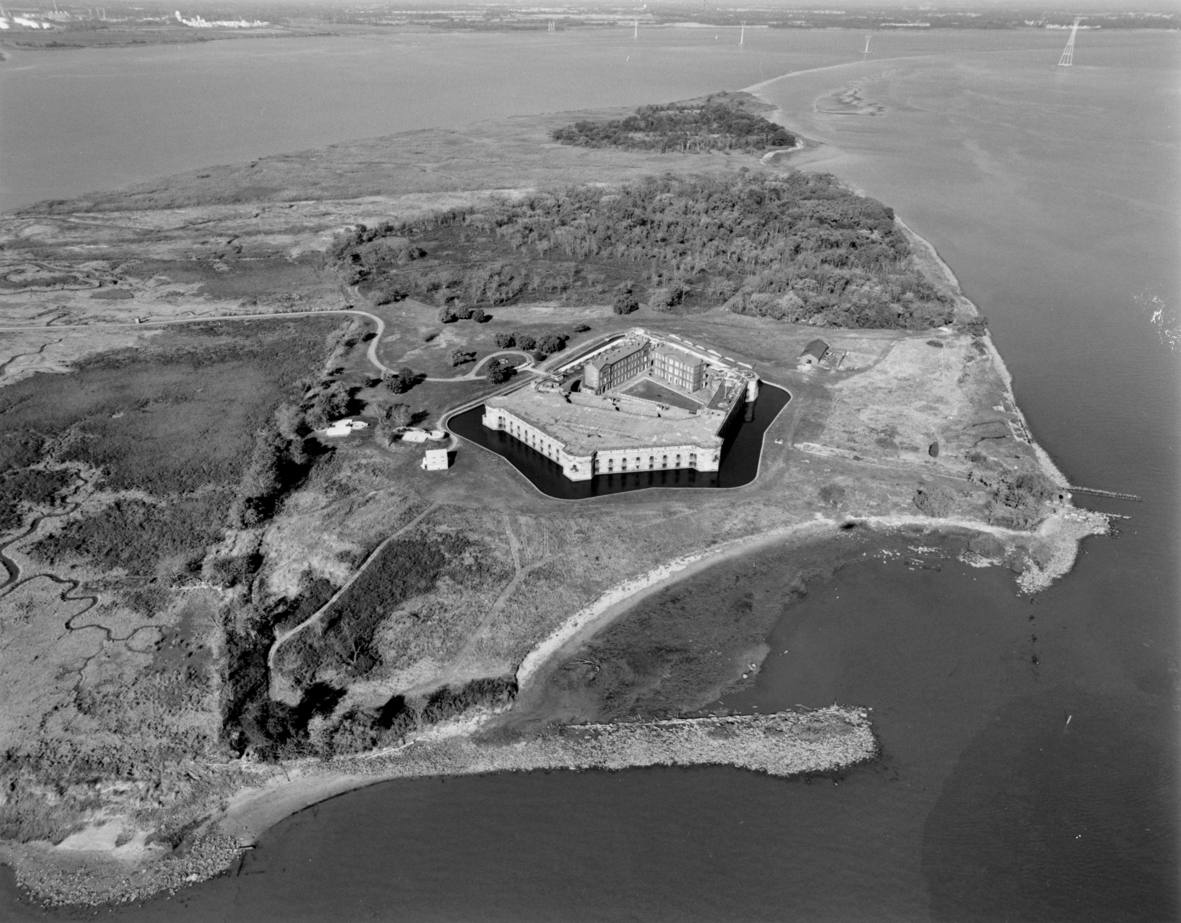
39°21′17″N 75°33′6″W / 39.35472°N 75.55167°WSmyrna 88 Fort Delaware on Pea Patch Island 
December 16, 1971 Pea Patch Island in the Delaware River
39°35′24″N 75°34′19″W / 39.59°N 75.57194°WDelaware City 89 Fort Dupont Historic District October 28, 1999 Delaware Route 9, south of Chesapeake and Delaware Canal Delaware City 90 Galloway-Walker House 
July 14, 1993 107 John St. in Christiana Hundred
39°42′43″N 75°36′40″W / 39.71194°N 75.61111°WNewport 91 Garrett Snuff Mill 
May 22, 1978 Junction of Delaware Route 82 and Yorklyn Rd.
39°48′31″N 75°40′26″W / 39.80861°N 75.67389°WYorklyn 92 Garrett Snuff Mills Historic District January 24, 1980 Delaware Route 82 and Yorklyn Rd.
39°48′37″N 75°40′18″W / 39.81028°N 75.67167°WYorklyn 93 Glebe House April 3, 1973 Delaware Route 9
39°40′7″N 75°33′34″W / 39.66861°N 75.55944°WNew Castle 94 J. M. Gordon House September 13, 1985 County Road 44
39°28′32″N 75°37′30″W / 39.47556°N 75.625°WOdessa 95 Robert Graham House 
August 1, 1997 751 Crossan Rd.
39°45′29″N 75°43′58″W / 39.75806°N 75.73278°WNewark 96 Granite Mansion 
February 24, 1983 292 W. Main St.
39°41′16″N 75°45′31″W / 39.68778°N 75.75861°WNewark 97 Graves Mill Historic District December 19, 1979 East of Yorklyn on Way Rd.
39°48′17″N 75°38′40″W / 39.80472°N 75.64444°WYorklyn 98 Green Mansion 
February 24, 1983 94-96 E. Main St.
39°41′0″N 75°45′3″W / 39.683333°N 75.75083°WNewark 99 Green Meadow September 11, 1992 Thomas Landing Rd. (Delaware Route 440) in Appoquinimink Hundred
39°26′53″N 75°36′50″W / 39.44806°N 75.61389°WOdessa 100 Greenbank Historic Area July 2, 1973 Greenbank Mill Rd., north of junction of Delaware Routes 2 and 41
39°44′24″N 75°37′59″W / 39.74°N 75.63306°WMarshallton 101 Greenlawn 
April 24, 1973 N. Broad St.
39°27′26″N 75°43′7″W / 39.45722°N 75.71861°WMiddletown 102 Robert Grose House September 21, 2001 1000 Port Penn Rd.
39°31′17″N 75°35′38″W / 39.52139°N 75.59389°WPort Penn 103 Hale-Byrnes House 
June 2, 1972 Corner of Delaware Routes 7 and 4
39°42′4″N 75°39′2″W / 39.70111°N 75.65056°WStanton 104 B. F. Hanson House April 27, 1982 West of Middletown
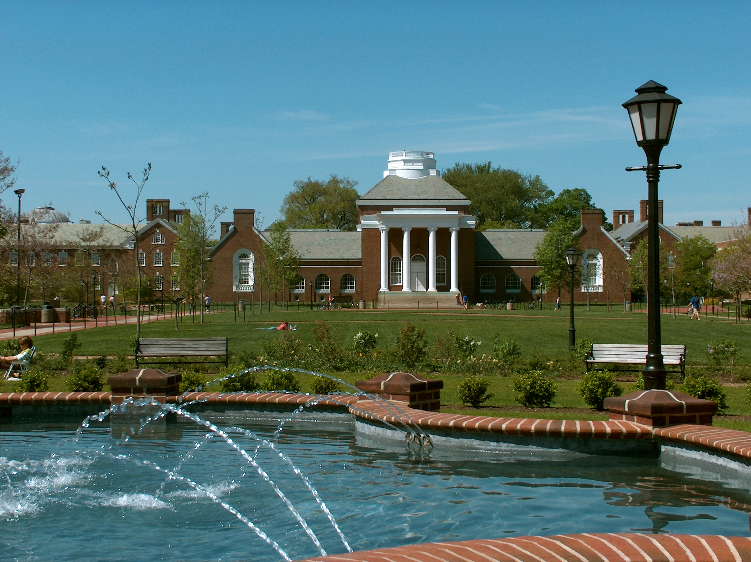
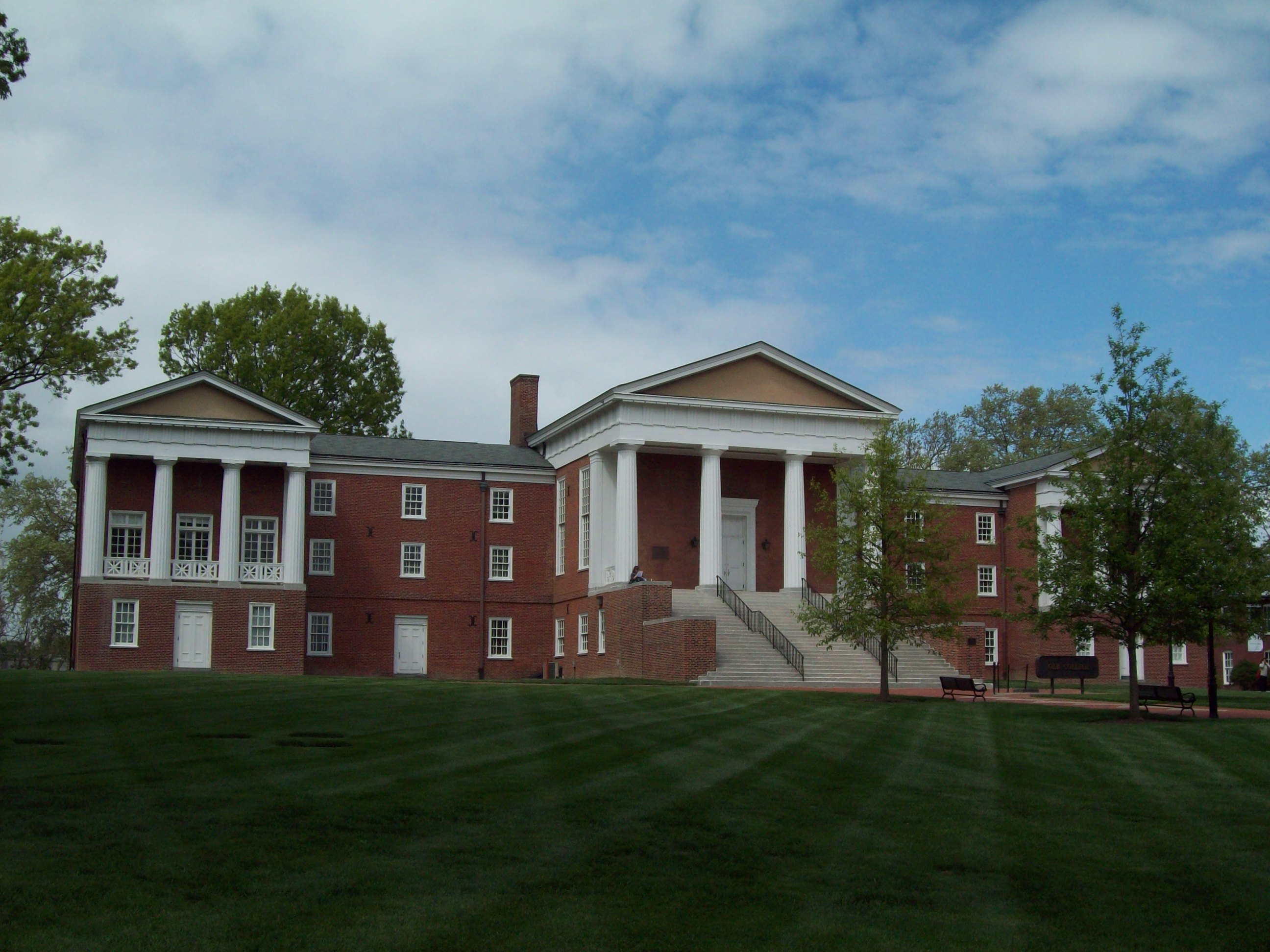
39°25′39″N 75°45′34″W / 39.4275°N 75.75944°WMiddletown 105 Hart House March 20, 1973 East of Taylors Bridge on County Road 453
39°24′18″N 75°32′35″W / 39.405°N 75.54306°WTaylors Bridge 106 Hazel Glen November 20, 1978 West of Port Penn on County Road 420
39°30′51″N 75°36′57″W / 39.51417°N 75.61583°WPort Penn 107 Head of Christiana United Presbyterian Church 
August 19, 1983 1100 Church Rd.
39°41′31″N 75°47′12″W / 39.69194°N 75.78667°WNewark 108 Hedgelawn 
April 3, 1973 1.2 miles west of Middletown on Delaware Route 299
39°26′28″N 75°44′31″W / 39.44111°N 75.74194°WMiddletown 109 Hell Island Site April 13, 1977 Address Restricted Odessa 110 The Hermitage March 1, 1973 On Delaware Route 273
39°39′51″N 75°34′10″W / 39.66417°N 75.56944°WNew Castle 111 William Hicklen House October 6, 1983 Address Restricted Talleyville 112 Hickman Blacksmith Shop and House September 2, 1994 1201 and 1203 Greenbank Rd.
39°43′44″N 75°38′18″W / 39.72889°N 75.63833°WMarshallton 113 Hickman Row 
June 16, 2006 1-117 Hickman Rd.
39°48′57″N 75°26′42″W / 39.81583°N 75.445°WClaymont 114 S. Higgins Farm September 13, 1985 County Road 423
39°29′43″N 75°37′37″W / 39.49528°N 75.62694°WOdessa 115 Hill Island Farm September 11, 1992 3379 Dupont Parkway (U.S. Route 13) in Appoquinimink Hundred
39°26′3″N 75°40′3″W / 39.43417°N 75.6675°WOdessa 116 Hockessin Friends Meetinghouse March 20, 1973 County Roads 254 and 275 at Meetinghouse Rd.
39°47′35″N 75°41′3″W / 39.79306°N 75.68417°WHockessin 117 Holladay-Harrington House September 30, 2004 3705 Kennett Pike
39°46′28″N 75°35′34″W / 39.77444°N 75.59278°WGreenville 118 S. Holton Farm September 13, 1985 County Road 435
39°28′25″N 75°44′10″W / 39.47361°N 75.73611°WMiddletown 119 Huguenot House March 20, 1973 West of Taylors Bridge on Delaware Route 9
39°23′59″N 75°36′59″W / 39.39972°N 75.61639°WTaylors Bridge 120 Idalia Manor September 13, 1985 U.S. Route 13
39°32′32″N 75°38′49″W / 39.54222°N 75.64694°WMt. Pleasant 121 Iron Hill School No. 112C August 18, 1995 1335 Old Baltimore Pike in Pencader Hundred
39°38′0″N 75°45′30″W / 39.633333°N 75.75833°WNewark 122 Ivyside Farm 
January 4, 1982 1301 Naaman's Rd.
39°49′16″N 75°28′39″W / 39.82111°N 75.4775°WClaymont 123 Johnson Home Farm September 11, 1992 County Road 453 east of junction with Delaware Route 9 in Blackbird Hundred
39°24′42″N 75°34′59″W / 39.41167°N 75.58306°WTaylor's Bridge 124 Johnson-Morris House February 22, 2011 41 Upper Pike Creek Rd.
39°42′19″N 75°41′47″W / 39.70528°N 75.69639°WNewark vicinity 125 William Julius "Judy" Johnson House October 10, 1995 3701 Kiamensi Ave. in Christiana Hundred
39°43′48″N 75°38′0″W / 39.73°N 75.633333°WMarshallton 126 Andrew Kerr House August 19, 1983 812 Elkton Rd.
39°40′17″N 75°46′12″W / 39.67139°N 75.77°WNewark 127 Killgore Hall 
July 14, 1993 101 N. James St. in Christiana Hundred
39°42′53″N 75°36′37″W / 39.71472°N 75.61028°WNewport Demolished c. 2000 128 Joseph Killgore House July 14, 1993 107 N. James St. in Christiana Hundred
39°42′53″N 75°36′37″W / 39.71472°N 75.61028°WNewport Demolished c. 2000 129 La Grange 
July 10, 1974 Near junction of U.S. Route 40 and Delaware Route 896
39°36′22″N 75°44′55″W / 39.60611°N 75.74861°WGlasgow 130 Lesley-Travers Mansion April 3, 1973 112 W. 6th St.
39°39′38″N 75°34′12″W / 39.66056°N 75.57°WNew Castle 131 John Lewden House 
September 24, 1979 107 E. Main St.
39°39′48″N 75°39′21″W / 39.66333°N 75.65583°WChristiana 132 Charles and Edith Liedlich House April 19, 2006 180 Welsh Tract Rd.
39°38′45″N 75°45′41″W / 39.64583°N 75.76139°WNewark 133 Linden Hill April 8, 1982 U.S. Route 13
39°33′48″N 75°39′20″W / 39.56333°N 75.65556°WSt. Georges 134 J. Lindsay Barn November 13, 1986 Middleton Rd. near Mermaid-Stoney Batter Rd.
39°45′4″N 75°41′18″W / 39.75111°N 75.68833°WNewark 135 Samuel Lindsey House August 19, 1983 New London Rd.
39°42′27″N 75°46′36″W / 39.7075°N 75.77667°WMcClellandville 136 Liston House March 26, 1973 East of Taylors Bridge on Delaware Route 453
39°24′17″N 75°32′35″W / 39.40472°N 75.54306°WTaylors Bridge 137 Liston Range Front Lighthouse 
January 14, 2004 1600 Belts Rd.
39°28′58″N 75°35′31″W / 39.48278°N 75.59194°WBay View Beach 138 Liston Range Rear Light Station 
November 15, 1978 West of Port Penn on Delaware Route 2
39°31′25″N 75°38′24″W / 39.52361°N 75.64°WPort Penn 139 Lum's Mill House May 22, 1973 Lums Pond State Park on Delaware Route 71
39°33′2″N 75°42′50″W / 39.55056°N 75.71389°WKirkwood 140 Comdr. Thomas MacDonough House December 12, 1978 North of Odessa on U.S. Route 13
39°29′29″N 75°39′4″W / 39.49139°N 75.65111°WOdessa 141 Maple Grove Farm September 13, 1985 Delaware Route 299
39°26′57″N 75°42′6″W / 39.44917°N 75.70167°WMiddletown 142 Maples February 17, 1978 West of Middletown on Bunker Hill Rd.
39°27′17″N 75°44′18″W / 39.45472°N 75.73833°WMiddletown 143 Marshallton United Methodist Church February 18, 1987 1105 Stanton Rd.
39°43′47″N 75°38′20″W / 39.72972°N 75.63889°WMarshallton 144 J. Mason Farm November 13, 1986 Delaware Route 82 south of Way Rd.
39°47′54″N 75°39′5″W / 39.79833°N 75.65139°WNewark 145 Mayfield August 1, 1997 1603 Levels Rd.
39°24′1″N 75°45′21″W / 39.40028°N 75.75583°WMiddletown 146 J. McCormack Farm November 13, 1986 Newport Gap Turnpike north of Mill Creek Rd.
39°45′17″N 75°39′24″W / 39.75472°N 75.65667°WNewark 147 McCoy House April 24, 1973 Kirkwood and McCoy Rds.
39°33′34″N 75°40′40″W / 39.55944°N 75.67778°WKirkwood 148 J. McDaniel Farm November 13, 1986 Paper Mill Rd. east of Pike Creek Rd.
39°44′56″N 75°43′0″W / 39.74889°N 75.716667°WNewark 149 J. McIntyre Farm November 13, 1986 Limestone Rd. north of Valley Rd.
39°46′38″N 75°43′20″W / 39.77722°N 75.72222°WNewark 150 McWhorter House September 13, 1985 County Road 412
39°32′32″N 75°39′42″W / 39.54222°N 75.66167°WOdessa 151 Meeteer House September 2, 1993 801 Kirkwood Highway in Mill Creek Hundred
39°41′44″N 75°43′6″W / 39.69556°N 75.71833°WNewark 152 Memorial Hall 
May 7, 1982 University of Delaware campus
39°40′44″N 75°45′8″W / 39.67889°N 75.75222°WNewark 153 Merestone 
March 2, 1995 1610-1620 Yeatman's Mill Rd. in Mill Creek Hundred
39°45′45″N 75°44′57″W / 39.7625°N 75.74917°WNewark Extends into Chester County, Pennsylvania 154 Mermaid Tavern December 18, 1973 Northeast of Newark on Delaware Route 7
39°44′34″N 75°41′41″W / 39.74278°N 75.69472°WNewark 155 Meteer Store House February 24, 1983 325 Paper Mill Rd.
39°40′59″N 75°45′0″W / 39.68306°N 75.75°WNewark 156 Middletown Academy 
December 5, 1972 218 N. Broad St.
39°27′5″N 75°43′4″W / 39.45139°N 75.71778°WMiddletown 157 Middletown Historic District 
October 4, 1978 Roughly bounded by Redding, Scott, Lockwood, and Catherine Sts.
39°23′0″N 75°43′2″W / 39.383333°N 75.71722°WMiddletown 158 Mill Creek Friends Meetinghouse 
April 3, 1973 6 miles north of Newark on Landenburg Rd.
39°45′59″N 75°44′30″W / 39.76639°N 75.74167°WNewark 159 Misty Vale September 13, 1985 County Road 423
39°29′23″N 75°38′20″W / 39.48972°N 75.63889°WOdessa 160 Mondamon Farm November 19, 1985 Delaware Route 2
39°31′26″N 75°38′29″W / 39.52389°N 75.64139°WOdessa 161 Montchanin Historic District 
June 9, 1978 Delaware Route 100
39°47′21″N 75°35′18″W / 39.78917°N 75.58833°WMontchanin 162 Monterey December 5, 1980 North of Odessa on Bayview Rd.
39°29′26″N 75°38′37″W / 39.49056°N 75.64361°WOdessa 163 William Morgan Farm 
November 13, 1986 Wilmington-Landenberg Rd. north of Corner Ketch Rd.
39°45′7″N 75°44′25″W / 39.75194°N 75.74028°WNewark 164 James Morrow House August 19, 1983 1210 Ogletown Rd.
39°41′8″N 75°43′25″W / 39.68556°N 75.72361°WNewark 165 Mt. Cuba Center April 2, 2003 3120 Barley Mill Rd.
39°47′25″N 75°38′54″W / 39.79028°N 75.64833°WGreenville 166 Mount Cuba Historic District December 19, 1979 Delaware Route 82 and County Road 261
39°47′22″N 75°38′26″W / 39.78944°N 75.64056°WMount Cuba 167 Mt. Airy School No. 27 
April 13, 1983 5925 Kennett Pike
39°49′36″N 75°37′12″W / 39.82667°N 75.62°WCentreville 168 Naaman's Creek School 
November 15, 1990 Junction of Philadelphia Pike and Darley Rd., Brandywine Creek
39°48′16″N 75°27′18″W / 39.80444°N 75.455°WClaymont 169 Arnold S. Naudain House April 24, 1973 South of Middletown on Delaware Route 71
39°25′15″N 75°42′14″W / 39.42083°N 75.70389°WMiddletown 170 John B. Nelson House December 8, 1978 West of Port Penn off U.S. Route 13 Port Penn 171 New Castle and Frenchtown Railroad Right-of-Way September 1, 1976 Off U.S. Route 40 between Frenchtown, Maryland[disambiguation needed  ] and Porter
39°35′37″N 75°45′54″W / 39.59361°N 75.765°WPorter 172 New Castle County Court House 
November 28, 1972 Delaware St., between 2nd and 3rd Sts.
39°39′35″N 75°33′49″W / 39.65972°N 75.56361°WNew Castle 173 New Castle Historic District 
December 24, 1967 and November 8, 1984 Roughly bounded by the Delaware River, Broad Dike, and 4th, 6th, 7th, and Penn Sts.; Bounded by Harmony St., The Strand, 3rd St., and Delaware St.
39°39′39″N 75°33′50″W / 39.66083°N 75.56389°WNew Castle 174 New Castle Ice Piers 
February 4, 1982 Delaware River
39°39′28″N 75°33′39″W / 39.65778°N 75.56083°WNew Castle 175 Newark Opera House 
May 7, 1982 95 E. Main St.
39°41′0″N 75°45′3″W / 39.683333°N 75.75083°WNewark 176 Newark Passenger Station 
May 7, 1982 S. College Ave. and Amtrak/Conrail railroad line
39°40′13″N 75°45′11″W / 39.67028°N 75.75306°WNewark 177 Newport National Bank July 14, 1993 100 E. Market St. in Christiana Hundred
39°42′49″N 75°36′31″W / 39.71361°N 75.60861°WNewport 178 Newport Railroad Station January 21, 1994 Northern side of James St. at the Penn Central railroad tracks
39°42′44″N 75°36′39″W / 39.71222°N 75.61083°WNewport 179 North Saint Georges Historic District August 22, 1995 Roughly along Main, Broad, Delaware, and Church Sts. in Red Lion Hundred
39°33′24″N 75°39′7″W / 39.55667°N 75.65194°WSt. Georges 180 Noxontown July 2, 1973 South of Middletown off Delaware Route 71
39°26′9″N 75°41′2″W / 39.43583°N 75.68389°WMiddletown 181 Odessa Historic District 
June 21, 1971 Bounded roughly by Appoquinimink Creek on the southeast, High St. on the northeast, 4th St. on the northwest, and Main St. on the southwest
39°27′14″N 75°39′23″W / 39.45389°N 75.65639°WOdessa 182 Okolona November 19, 1985 County Road 429
39°28′35″N 75°37′52″W / 39.47639°N 75.63111°WMiddletown 183 Old Brick Store 
August 14, 1973 Northeast of Smyrna off U.S. Route 13
39°19′21″N 75°34′26″W / 39.3225°N 75.57389°WSmyrna 1767 Brick Store 184 Old Cann Mansion House April 8, 1982 Delaware Route 71
39°34′26″N 75°41′35″W / 39.57389°N 75.69306°WKirkwood 185 Old College Historic District 
June 4, 1973 Main and College Sts. on the University of Delaware campus
39°41′3″N 75°45′10″W / 39.68417°N 75.75278°WNewark 186 Old Drawyers Church 
February 6, 1973 U.S. Route 13
39°28′1″N 75°39′15″W / 39.46694°N 75.65417°WOdessa 187 Old First Presbyterian Church 
May 7, 1982 W. Main St.
39°40′57″N 75°45′25″W / 39.6825°N 75.75694°WNewark 188 Old Ford Dairy September 13, 1985 U.S. Route 13
39°32′24″N 75°39′10″W / 39.54°N 75.65278°WOdessa 189 Old Fort Church 
August 19, 1983 Old Baltimore Pike
39°40′4″N 75°39′34″W / 39.66778°N 75.65944°WChristiana 190 Old Newark Comprehensive School 
May 7, 1982 83 E. Main St.
39°41′0″N 75°44′58″W / 39.683333°N 75.74944°WNewark 191 Old Post Office April 8, 1982 Kirkwood and St. Georges Rd.
39°34′15″N 75°41′49″W / 39.57083°N 75.69694°WKirkwood 192 Old St. Anne's Church 
March 7, 1973 South of Middletown off Delaware Route 71
39°26′9″N 75°42′46″W / 39.43583°N 75.71278°WMiddletown 193 Old St. Paul's Methodist Episcopal Church May 13, 1982 High St.
39°27′25″N 75°39′36″W / 39.45694°N 75.66°WOdessa 194 Old Union Methodist Church January 18, 1973 0.2 mile north of Blackbird Crossroads on U.S. Route 13
39°23′15″N 75°39′49″W / 39.3875°N 75.66361°WBlackbird Crossroads 195 Ott's Chapel August 13, 1986 County Road 397
39°38′35″N 75°46′45″W / 39.64306°N 75.77917°WNewark 196 Owl's Nest Country Place 
August 30, 2010 201 Owl's Nest Rd
39°48′55″N 75°37′27″W / 39.81528°N 75.62417°WGreenville vicinity 197 Penn Farm of the Trustees of the New Castle Common September 11, 1997 807 Frenchtown Pike
39°40′1″N 75°35′33″W / 39.66694°N 75.5925°WNew Castle 198 Pharo House August 9, 1984 Odessa and Silver Lake Rds.
39°26′55″N 75°41′45″W / 39.44861°N 75.69583°WMiddletown 199 Thomas Phillips Mill Complex 
August 19, 1983 708 and 712 Nottingham Rd.
39°41′29″N 75°46′40″W / 39.69139°N 75.77778°WNewark 200 T. Pierson Farm November 13, 1986 Southwood Rd.
39°47′18″N 75°42′58″W / 39.78833°N 75.71611°WNewark 201 Point Farm April 8, 1982 U.S. Route 301 South
39°33′17″N 75°42′10″W / 39.55472°N 75.70278°WKirkwood 202 Poplar Hall January 26, 1988 3176 Denny Rd.
39°33′22″N 75°46′23″W / 39.55611°N 75.77306°WNewark 203 Port Penn Historic District November 20, 1978 Delaware Route 9
39°30′57″N 75°34′34″W / 39.51583°N 75.57611°WPort Penn 204 Public School No. 111-C October 18, 1979 Delaware Route 7
39°40′7″N 75°39′31″W / 39.66861°N 75.65861°WChristiana 205 Public School No. 29 May 22, 1978 Valley Rd. and Old Lancaster Pike
39°47′21″N 75°42′3″W / 39.78917°N 75.70083°WHockessin 206 Philip Reading Tannery April 26, 1978 201 E. Main St.
39°27′2″N 75°42′44″W / 39.45056°N 75.71222°WMiddletown 207 Red Clay Creek Presbyterian Church April 11, 1973 Mill Creek and McKennan's Church Rds.
39°45′8.73″N 75°39′33.34″W / 39.752425°N 75.6592611°WNewport 208 Reedy Island Range Rear Light 
March 27, 1989 Junction of Delaware Route 9 and County Road 453
39°24′23″N 75°35′26″W / 39.40639°N 75.59056°WTaylor's Bridge 209 Retirement Farm September 13, 1985 U.S. Route 13
39°30′52″N 75°38′39″W / 39.51444°N 75.64417°WOdessa 210 Rhodes Pharmacy 
February 24, 1983 36 E. Main St.
39°41′0″N 75°45′7″W / 39.683333°N 75.75194°WNewark 211 Riverdale November 19, 1985 Off Bay View and Silver Run Rds. Odessa 212 Robinson House 
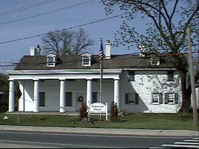
June 21, 1971 Naaman's Corner
39°48′36″N 75°26′32″W / 39.81°N 75.44222°WClaymont 213 Rockland Historic District 
February 1, 1972 Town of Rockland and its environs along Rockland Rd. and Brandywine Creek
39°47′48″N 75°34′28″W / 39.79667°N 75.57444°WRockland 214 Rosedale September 13, 1985 County Road 437
39°27′43″N 75°44′43″W / 39.46194°N 75.74528°WMiddletown 215 Rotheram Mill House January 4, 1972 318 Harmony Rd.
39°41′48″N 75°41′40″W / 39.69667°N 75.69444°WNewark 216 Rumsey Farm March 30, 1978 West of Middletown on Delaware Route 299
39°26′29″N 75°44′58″W / 39.44139°N 75.74944°WMiddletown 217 St. Georges Cemetery Caretaker's House April 8, 1982 Kirkwood and St. Georges Rd.
39°33′37″N 75°40′12″W / 39.56028°N 75.67°WSt. Georges 218 St. Georges Presbyterian Church November 7, 1984 Main St.
39°33′21″N 75°39′8″W / 39.55583°N 75.65222°WSt. Georges 219 St. James Episcopal Church, Mill Creek 
May 8, 1973 West of Stanton on St. James Church Rd.
39°43′8″N 75°39′43″W / 39.71889°N 75.66194°WStanton 220 St. John the Baptist Roman Catholic Church 
May 7, 1982 200 E. Main St.
39°41′2″N 75°44′44″W / 39.68389°N 75.74556°WNewark 221 St. Joseph's Church February 17, 1978 15 W. Cochran St.
39°26′50″N 75°43′7″W / 39.44722°N 75.71861°WMiddletown 222 St. Joseph's on the Brandywine 
November 7, 1976 10 Barley Mill Rd.
39°46′20″N 75°35′20″W / 39.77222°N 75.58889°WGreenville 223 St. Thomas Episcopal Church 
May 7, 1982 21 Elkton Rd.
39°40′55″N 75°45′25″W / 39.68194°N 75.75694°WNewark 224 Sereck Shallcross House April 3, 1973 West of Odessa off U.S. Route 13
39°28′16″N 75°41′26″W / 39.47111°N 75.69056°WOdessa 225 Springer Farm November 13, 1986 Limestone Rd.
39°47′9″N 75°43′22″W / 39.78583°N 75.72278°WNewark 226 Springer-Cranston House September 30, 1994 1015 Stanton Rd. in Mill Creek Hundred
39°43′33″N 75°38′19″W / 39.72583°N 75.63861°WMarshallton 227 Starl House April 8, 1982 U.S. Route 13
39°34′44″N 75°39′30″W / 39.57889°N 75.65833°WSt. Georges 228 State Theater February 24, 1983 39 E. Main St.
39°40′55″N 75°45′1″W / 39.68194°N 75.75028°WNewark The State Theater was demolished in 1989.[4] 229 James Steel House August 19, 1983 1016 W. Church St.
39°41′30″N 75°47′6″W / 39.69167°N 75.785°WNewark 230 James Stewart House June 11, 1986 County Road 401
39°36′2″N 75°42′56″W / 39.60056°N 75.71556°WGlasgow 231 James Stewart, Jr., House August 19, 1983 Whitten Rd.
39°38′26″N 75°41′1″W / 39.64056°N 75.68361°WChristiana 232 J. Stinson Farm 
November 13, 1986 750 Corner Ketch Rd.
39°44′39″N 75°43′52″W / 39.74417°N 75.73111°WNewark 233 Stonum 
November 7, 1973 9th and Washington Sts.
39°39′39″N 75°34′38″W / 39.66083°N 75.57722°WNew Castle 234 Strand Millas and Rock Spring July 16, 1973 Between Rockland and Montchanin off Delaware Route 100
39°47′32″N 75°35′2″W / 39.79222°N 75.58389°WMontchanin 235 Sutton House April 24, 1973 Broad and Delaware Sts.
39°33′20″N 75°39′1″W / 39.55556°N 75.65028°WSt. Georges 236 Swanwyck March 17, 1977 65 Landers Lane
39°41′40″N 75°33′56″W / 39.69444°N 75.56556°WNew Castle 237 Joseph Tatnall House 
July 14, 1993 Western side of S. James St. near Christiana Creek, in Christiana Hundred
39°42′39″N 75°36′36″W / 39.71083°N 75.61°WNewport Now part of a DuPont chemical complex 238 David W. Thomas House September 11, 1992 326 Thomas Landing Rd. in Appoquinimink Hundred
39°26′45″N 75°37′38″W / 39.44583°N 75.62722°WOdessa 239 Townsend Historic District May 8, 1986 Roughly bounded by Gray, Ginn and South, Lattamus and Main Sts., and Commerce St. and Cannery Ln. and Railroad Ave.
39°23′39″N 75°41′33″W / 39.39417°N 75.6925°WTownsend 240 A. M. Vail House September 13, 1985 Delaware Route 299
39°27′11″N 75°42′4″W / 39.45306°N 75.70111°WOdessa 241 J. Vandegrift House September 13, 1985 County Road 44
39°28′18″N 75°37′51″W / 39.47167°N 75.63083°WOdessa 242 Vandyke-Heath House September 11, 1992 385 Green Spring-Vandyke Rd. (County Road 47) in Appoquinimink Hundred
39°21′26″N 75°44′53″W / 39.35722°N 75.74806°WTownsend 243 John C. Vansant House February 16, 1989 110 Possum Hollow Rd.
39°42′50″N 75°43′37″W / 39.71389°N 75.72694°WNewark 244 Vernacular Frame House April 8, 1982 Delaware St.
39°33′24″N 75°38′54″W / 39.55667°N 75.64833°WSt. Georges 245 Village of Arden 
February 6, 1973 6 miles north of Wilmington between Marsh Rd., Naaman's Creek, and Ardentown
39°48′40″N 75°29′14″W / 39.81111°N 75.48722°WArden 246 R. Walker Barn November 13, 1986 Near corner of Skyline and Foxcroft Drs.
39°44′16″N 75°41′47″W / 39.73778°N 75.69639°WNewark 247 Walnut Green School 
August 19, 1994 Junction of Delaware Route 82 and Owl's Nest Rd.
39°47′36″N 75°37′32″W / 39.79333°N 75.62556°WGreenville 248 Walnut Lane July 22, 1979 East of Newark at 4133 Ogletown Rd.
39°41′2″N 75°41′3″W / 39.68389°N 75.68417°WNewark 249 Lewis Weldin House 
July 14, 1993 7-9 W. Market St. in Christiana Hundred
39°42′49″N 75°36′38″W / 39.71361°N 75.61056°WNewport 250 Welsh Tract Baptist Church 
March 1, 1973 Welsh Tract Rd.
39°39′1″N 75°45′7″W / 39.65028°N 75.75194°WNewark 251 Wesley M.E. Church August 19, 1983 Delaware Route 896
39°42′42″N 75°46′45″W / 39.71167°N 75.77917°WMcClellandville 252 Weston November 19, 1985 Off Delaware Route 71
39°29′45″N 75°42′30″W / 39.49583°N 75.70833°WMiddletown 253 White Clay Creek Presbyterian Church 
March 20, 1973 2 miles northeast of Newark on Delaware Route 2
39°41′55″N 75°42′41″W / 39.69861°N 75.71139°WNewark 254 White Hall July 12, 1990 130 Michael Ln.
39°34′23″N 75°43′18″W / 39.57306°N 75.72167°WBear 255 Williams House June 4, 1973 1.2 miles northwest of Odessa on Marl Pit Rd.
39°28′0″N 75°40′50″W / 39.466667°N 75.68056°WOdessa 256 J. K. Williams House September 13, 1985 Delaware Route 299
39°27′16″N 75°41′32″W / 39.45444°N 75.69222°WOdessa 257 Wilmington and Western Railroad 
September 8, 1980 Delaware Route 41 and Greenbank Road
39°44′18.7″N 75°37′58″W / 39.738528°N 75.63278°WHockessin 258 Wilmington Trust Company Bank 
May 7, 1982 82 E. Main St.
39°41′0″N 75°45′0″W / 39.683333°N 75.75°WNewark 259 Edward R. Wilson House April 25, 1983 521 S. College Ave
39°40′8″N 75°45′4″W / 39.66889°N 75.75111°WNewark 260 Windsor September 11, 1992 1060 Dutch Neck Rd. in St. Georges Hundred
39°32′48″N 75°36′53″W / 39.54667°N 75.61472°WPort Penn 261 Winterthur Museum and Gardens 
February 24, 1971 6 miles northwest of Wilmington on Delaware Route 52
39°48′31″N 75°36′1″W / 39.80861°N 75.60028°WWinterthur 262 Woman's Club of Newport 
July 14, 1993 15 N. Augustine St. in Christiana Hundred
39°42′53″N 75°36′23″W / 39.71472°N 75.60639°WNewport 263 Wooddale Bridge April 11, 1973 Over Red Clay Creek off Delaware Route 48
39°45′57″N 75°38′14″W / 39.76583°N 75.63722°WWooddale 264 Wooddale Historic District August 24, 1979 Northwest of Newport on Wooddale Rd
39°46′8″N 75°38′19″W / 39.76889°N 75.63861°WNewport 265 Woodside September 13, 1985 County Road 435
39°30′30″N 75°45′1″W / 39.50833°N 75.75028°WMt. Pleasant 266 Wright House 
May 7, 1982 47 Kent Way
39°40′42″N 75°45′24″W / 39.67833°N 75.75667°WNewark 267 William Young House October 29, 1982 East of Rockland on County Road 228
39°47′40″N 75°33′54″W / 39.79444°N 75.565°WRockland See also
- National Register of Historic Places listings in Delaware
- List of National Historic Landmarks in Delaware
References
- ^ The latitude and longitude information provided in this table was derived originally from the National Register Information System, which has been found to be fairly accurate for about 99% of listings. For about 1% of NRIS original coordinates, experience has shown that one or both coordinates are typos or otherwise extremely far off; some corrections may have been made. A more subtle problem causes many locations to be off by up to 150 yards, depending on location in the country: most NRIS coordinates were derived from tracing out latitude and longitudes off of USGS topographical quadrant maps created under the North American Datum of 1927, which differs from the current, highly accurate WGS84 GPS system used by Google maps. Chicago is about right, but NRIS longitudes in Washington are higher by about 4.5 seconds, and are lower by about 2.0 seconds in Maine. Latitudes differ by about 1.0 second in Florida. Some locations in this table may have been corrected to current GPS standards.
- ^ "National Register of Historic Places: Weekly List Actions". National Park Service, United States Department of the Interior. Retrieved on November 10, 2011.
- ^ Terri Sanginiti, robin brown. Two Hockessin teens charged in farmhouse arson. The (Wilmington, DE) News Journal. 2010-09-22. URL:http://www.delawareonline.com/article/20100904/NEWS01/9040336/Two-Hockessin-teens-charged-in-farmhouse-arson. Accessed: 2010-09-22. (Archived by WebCite® at http://www.webcitation.org/5swlwjOT2)
- ^ "Newark timeline". The News Journal. delawareonline.com. http://www.delawareonline.com/article/99999999/HOMES05/60112013/Newark-timeline. Retrieved 2010-12-01.
U.S. National Register of Historic Places Topics Lists by states Alabama • Alaska • Arizona • Arkansas • California • Colorado • Connecticut • Delaware • Florida • Georgia • Hawaii • Idaho • Illinois • Indiana • Iowa • Kansas • Kentucky • Louisiana • Maine • Maryland • Massachusetts • Michigan • Minnesota • Mississippi • Missouri • Montana • Nebraska • Nevada • New Hampshire • New Jersey • New Mexico • New York • North Carolina • North Dakota • Ohio • Oklahoma • Oregon • Pennsylvania • Rhode Island • South Carolina • South Dakota • Tennessee • Texas • Utah • Vermont • Virginia • Washington • West Virginia • Wisconsin • WyomingLists by territories Lists by associated states Other  State of Delaware
Topics - Index
- Architecture
- Communications
- Culture
- Delegations
- Demographics
- Economy
- Education
- Geography
- Government
- History
- Images
- Landmarks
- Law
- Military
- Music
- Nature
- Organizations
- Parks
- Sports
- Symbols
- Transportation
- Visitor Attractions
Cities Towns - Arden
- Ardencroft
- Ardentown
- Bellefonte
- Bethany Beach
- Bethel
- Blades
- Bowers
- Bridgeville
- Camden
- Cheswold
- Clayton
- Dagsboro
- Delmar
- Dewey Beach
- Ellendale
- Elsmere
- Farmington
- Felton
- Fenwick Island
- Frankford
- Frederica
- Georgetown
- Greenwood
- Hartly
- Henlopen Acres
- Houston
- Kenton
- Laurel
- Leipsic
- Little Creek
- Magnolia
- Middletown
- Millsboro
- Millville
- Milton
- Newport
- Ocean
- Odessa
- Selbyville
- Slaughter Beach
- South Bethany
- Townsend
- Viola
- Woodside
- Wyoming
Counties Categories:- New Castle County, Delaware
- National Register of Historic Places in Delaware
-


Wikimedia Foundation. 2010.