- National Register of Historic Places listings in Sussex County, Delaware
-
List of the National Register of Historic Places listings in Sussex County, Delaware.
-
- This National Park Service list is complete through NPS recent listings posted November 10, 2011.[1]
Contents: Counties in Delaware
Kent | New Castle | Sussex Landmark name Image Date listed Location City or Town Summary 1 Abbott's Mill August 25, 1972 Southwest of Milford
38°53′10″N 75°28′36″W / 38.88611°N 75.47667°WMilford 2 Joseph T. Adams House August 28, 1998 12 E. Pine St.
38°41′29″N 75°23′3″W / 38.69139°N 75.38417°WGeorgetown 3 All Saints Episcopal Church August 2, 1991 18 Olive Ave. in Lewes and Rehoboth Hundred
38°43′7″N 75°4′42″W / 38.71861°N 75.07833°WRehoboth Beach 4 Avery's Rest Site December 15, 1978 Address restricted Rehoboth Beach 5 Baltimore Mills Historic Archaeological Site August 12, 1997 Address restricted Omar 6 Barnes Woods Archeological District December 11, 1996 Address restricted Seaford 7 Bethel Historic District February 10, 1975 0.4 miles west of Laurel
38°34′38″N 75°37′55″W / 38.57722°N 75.63194°WBethel 8 Blackwater Presbyterian Church 
July 9, 1976 West of Clarksville on Delaware Route 54
38°32′44″N 75°9′43″W / 38.54556°N 75.16194°WClarksville 9 Brick Hotel November 13, 1979 The Circle
38°41′23″N 75°23′13″W / 38.68972°N 75.38694°WGeorgetown 10 Bridgeville Historic District April 14, 1994 Roughly bounded by Market, Main and Edgewood Sts., School House Ln., Maple Alley and the Penn Central railroad tracks
38°44′28″N 75°36′6″W / 38.74111°N 75.60167°WBridgeville 11 Bridgeville Public Library July 23, 1990 210 Market St.
38°44′36″N 75°36′10″W / 38.74333°N 75.60278°WBridgeville 12 Building at 200-202A High Street February 18, 1987 200-202A High St.
38°38′26″N 75°36′47″W / 38.64056°N 75.61306°WSeaford 13 Building at 218 High Street February 18, 1987 218 High St.
38°38′28″N 75°36′44″W / 38.64111°N 75.61222°WSeaford 14 Building at High and Cannon Streets February 18, 1987 Southeastern corner of High and Cannon Sts.
38°38′27″N 75°36′42″W / 38.64083°N 75.61167°WSeaford 15 Burton Hardware Store April 20, 1978 High St. and Spring Alley
38°38′29″N 75°36′39″W / 38.64139°N 75.61083°WSeaford 16 Cannon's Ferry 
July 2, 1973 Across the Nanticoke River
38°36′0″N 75°39′25″W / 38.6°N 75.65694°WWoodland 17 Cape Henlopen Archeological District November 21, 1978 Address restricted Lewes 18 Carey's Camp Meeting Ground March 14, 1973 West of Millsboro off Delaware Route 24 Millsboro 19 Carlisle House April 22, 1982 205 S. Front St.
38°54′45″N 75°25′32″W / 38.9125°N 75.42556°WMilford 20 Capt. Ebe Chandler House September 20, 1979 Main and Reed Sts.
38°31′1″N 75°14′2″W / 38.51694°N 75.23389°WFrankford 21 Chipman Potato House November 15, 1990 Junction of County Roads 465 and 465A
38°33′37″N 75°32′14″W / 38.56028°N 75.53722°WLaurel 22 Chipman's Mill May 22, 1978 East of Laurel on County Road 465
38°33′42″N 75°32′24″W / 38.56167°N 75.54°WLaurel 23 Coleman House 
April 11, 1977 422 Kings Hwy.
38°46′12″N 75°8′31″W / 38.77°N 75.14194°WLewes 24 Collins Potato House November 15, 1990 Junction of County Roads 509 and 510A
38°31′35″N 75°36′18″W / 38.52639°N 75.605°WLaurel 25 Cool Spring Presbyterian Church August 31, 1982 West of Lewes on County Road 247
38°44′13″N 75°14′21″W / 38.73694°N 75.23917°WLewes 26 J. W. Cox Dry Goods Store February 18, 1987 214 High St.
38°38′27″N 75°36′44″W / 38.64083°N 75.61222°WSeaford 27 Robert Davis Farmhouse April 26, 1979 South of Delaware Route 24
38°36′30″N 75°12′13″W / 38.60833°N 75.20361°WMillsboro 28 Dr. Dawson House January 7, 1983 200 SE. Front St.
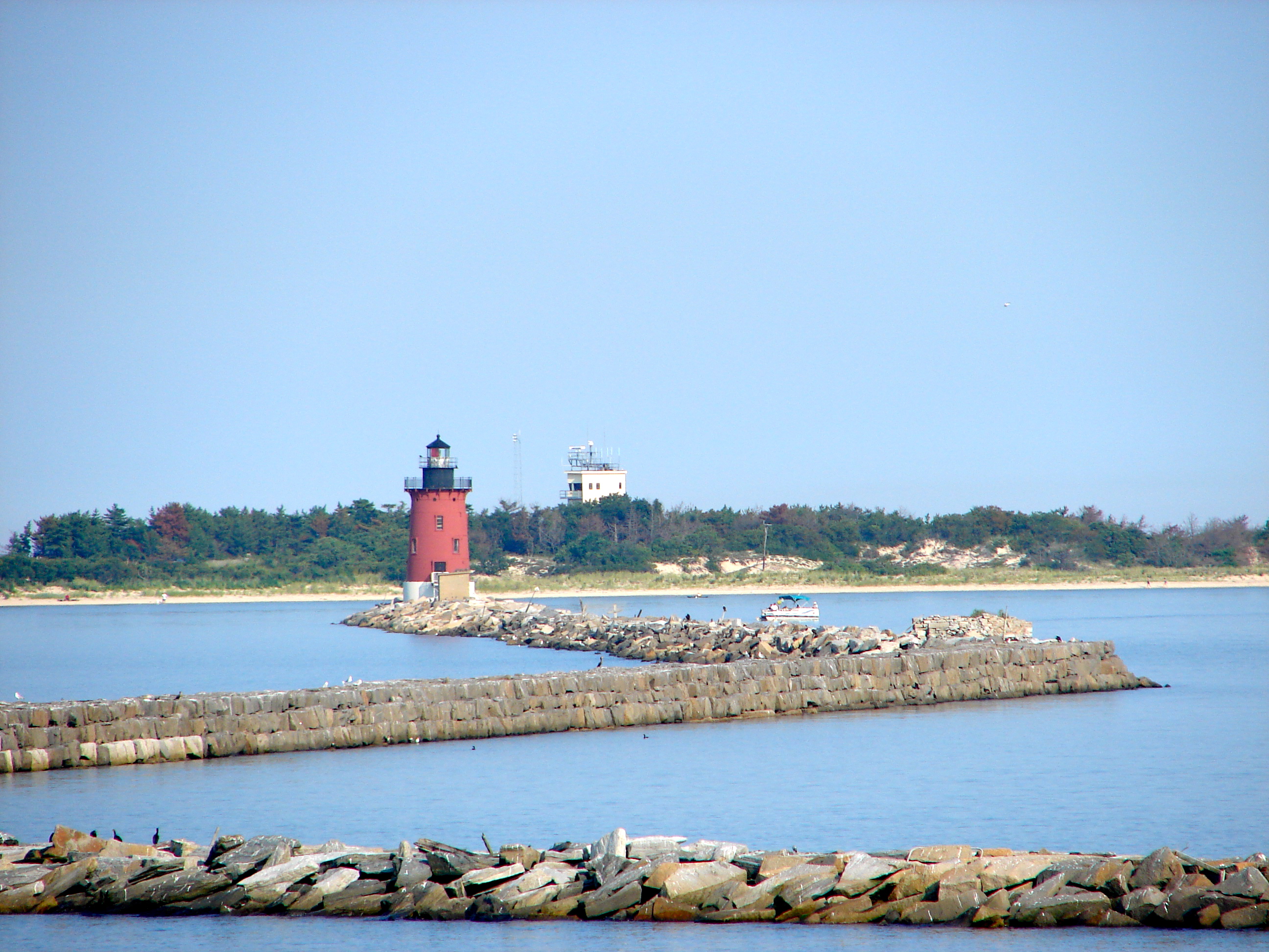
38°54′43″N 75°25′34″W / 38.91194°N 75.42611°WMilford 29 De Vries Palisade February 23, 1972 Address restricted Lewes 30 Deep Creek Furnace Site October 20, 1977 Address restricted Middleford 31 Delaware Boundary Markers February 18, 1975 Delaware state boundary lines with Maryland and Pennsylvania Not applicable 32 Delaware Breakwater and Lewes Harbor 
December 12, 1976 East of Lewes at Cape Henlopen
38°49′3″N 75°6′23″W / 38.8175°N 75.10639°WLewes 33 Dickerson Potato House November 15, 1990 Junction of County Roads 494 and 498
38°33′0″N 75°40′28″W / 38.55°N 75.67444°WDelmar 34 Dodd Homestead August 26, 1982 West of Rehoboth Beach on Delaware Route 1
38°43′1″N 75°6′40″W / 38.71694°N 75.11111°WRehoboth Beach 35 Draper House April 22, 1982 200 Lakeview Ave.
38°54′36″N 75°26′0″W / 38.91°N 75.433333°WMilford 36 Draper-Adkins House April 11, 1973 204 Federal St.
38°46′36″N 75°18′41″W / 38.77667°N 75.31139°WMilton 37 Egglinton Hall January 7, 1983 700 SE. 2nd St.
38°54′34″N 75°25′15″W / 38.90944°N 75.42083°WMilford 38 Ellendale State Forest Picnic Facility July 22, 1991 U.S. Route 113, ½ mile south of Delaware Route 16 in Georgetown Hundred
38°46′32″N 75°26′15″W / 38.77556°N 75.4375°WEllendale 39 Eratt House October 29, 1983 West of Bridgeville on County Road 572
38°45′21″N 75°42′40″W / 38.75583°N 75.71111°WBridgeville 40 Peter S. Faucett House September 5, 1985 W. Laurel St.
38°41′24″N 75°23′18″W / 38.69°N 75.38833°WGeorgetown 41 Fenwick Island Lighthouse Station 
August 13, 1979 Off Delaware Route 54
38°27′5″N 75°3′19″W / 38.45139°N 75.05528°WFenwick Island 42 First Broiler House July 3, 1974 University of Delaware Experimental Station
38°38′9″N 75°27′16″W / 38.63583°N 75.45444°WGeorgetown 43 First National Bank of Seaford February 18, 1987 118 Pine St.
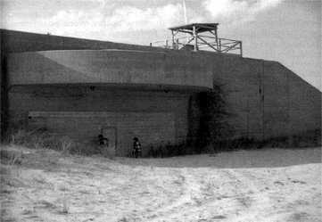
38°38′31″N 75°36′44″W / 38.64194°N 75.61222°WSeaford 44 Fisher Homestead December 11, 1980 West of Lewes
38°47′21″N 75°12′23″W / 38.78917°N 75.20639°WLewes 45 Fisher's Paradise December 4, 1972 624 Pilottown Rd.
38°47′1″N 75°9′26″W / 38.78361°N 75.15722°WLewes 46 Fort Miles Historic District 
September 30, 2004 At the confluence of the Atlantic Ocean and Delaware Bay
38°46′15″N 75°17′53″W / 38.77083°N 75.29806°WLewes 47 Georgetown Coal Gasification Plant September 30, 1985 N. Railroad Ave.
38°41′40″N 75°23′18″W / 38.69444°N 75.38833°WGeorgetown 48 Grier House January 7, 1983 301 Lakeview Ave.
38°54′32″N 75°26′7″W / 38.90889°N 75.43528°WMilford 49 Stella Pepper Gyles House November 13, 1979 Southwest of Georgetown
38°39′43″N 75°24′23″W / 38.66194°N 75.40639°WGeorgetown 50 Col. David Hall House 
April 26, 1976 107 King's Hwy.
38°46′25″N 75°8′20″W / 38.77361°N 75.13889°WLewes 51 Harmon School April 26, 1979 South of junction of Delaware Route 24 and County Road 297
38°36′50″N 75°12′9″W / 38.61389°N 75.2025°WMillsboro 52 Isaac Harmon Farmhouse April 26, 1979 County Road 312A
38°35′56″N 75°11′55″W / 38.59889°N 75.19861°WMillsboro 53 Harmony Church April 26, 1979 Delaware Route 24, east of County Road 313
38°36′21″N 75°13′8″W / 38.60583°N 75.21889°WMillsboro 54 Hazzard House July 2, 1973 327 Union St.
38°46′55″N 75°18′46″W / 38.78194°N 75.31278°WMilton 55 Hearn and Rawlins Mill May 22, 1978 North of Seaford on U.S. Route 13A
38°40′44″N 75°35′39″W / 38.67889°N 75.59417°WSeaford 56 Hearn Potato House November 15, 1990 0.6 miles north of junction of County Roads 62 and 74
38°35′8″N 75°27′35″W / 38.58556°N 75.45972°WLaurel 57 Highball Signal July 2, 1973 City park, near Penn Central railroad line.
38°27′23″N 75°34′44″W / 38.45639°N 75.57889°WDelmar 58 E. L. Hitch Potato House November 15, 1990 Junction of County Roads 460 and 489
38°36′11″N 75°33′48″W / 38.60306°N 75.56333°WLaurel 59 Ames Hitchens Chicken Farm April 26, 1979 North of Delaware Route 24
38°36′25″N 75°13′6″W / 38.60694°N 75.21833°WMillsboro 60 Hopkins' Covered Bridge Farm August 2, 1991 Northern side of County Road 262 east of its junction with County Road 286 in Lewes and Rehoboth Hundred
38°43′10″N 75°13′14″W / 38.71944°N 75.22056°WLewes 61 Indian Mission Church April 26, 1979 Junction of Delaware Route 5 and County Road 48
38°40′25″N 75°14′5″W / 38.67361°N 75.23472°WMillsboro 62 Indian Mission School April 26, 1979 Delaware Route 24 between County Roads 312A and 313A
38°36′21″N 75°12′43″W / 38.60583°N 75.21194°WMillsboro 63 Indian River Archeological Complex December 15, 1978 Address restricted Millsboro 64 Indian River Life Saving Service Station September 29, 1976 North of Bethany Beach on Delaware Route 1
38°38′1″N 75°4′3″W / 38.63361°N 75.0675°WBethany Beach 65 Johnson School April 26, 1979 Delaware Route 24 between County Roads 309 and 310
38°36′13″N 75°13′50″W / 38.60361°N 75.23056°WMillsboro 66 Judge's House and Law Office 
November 13, 1979 100 and 104 W. Market St.
38°41′21″N 75°23′17″W / 38.68917°N 75.38806°WGeorgetown 67 Laurel Historic District July 27, 1988 West St. to Rossakatum Creek to 10th St.
38°33′22″N 75°34′17″W / 38.55611°N 75.57139°WLaurel 68 Lawrence May 22, 1978 North of Seaford on U.S. Route 13A
38°39′43″N 75°36′4″W / 38.66194°N 75.60111°WSeaford 69 Lewes Historic District September 19, 1977 Ship-carpenter, Front, Savannah, 2nd, 3rd, and 4th Sts.
38°46′29″N 75°8′34″W / 38.77472°N 75.14278°WLewes 70 Lewes Presbyterian Church October 5, 1977 100 Kings Highway
38°46′20″N 75°8′23″W / 38.77222°N 75.13972°WLewes 71 Lightship WAL 539 
February 16, 1989 Lewes-Rehoboth Canal between Shipcarpenter and Mulberry Sts.
38°46′42″N 75°8′30″W / 38.77833°N 75.14167°WLewes Unique lightship was one of few that remained in service during World War II 72 Peter Marsh House 
November 23, 1977 10 Dodd's Lane
38°43′30″N 75°5′11″W / 38.725°N 75.08639°WRehoboth Beach 73 Maston House March 31, 1975 3 miles north of Seaford on Seaford-Atlanta Rd.
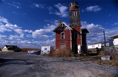
38°41′20″N 75°38′58″W / 38.68889°N 75.64944°WSeaford 74 Maull House 
November 20, 1970 542 Pilottown Rd. Lewes 75 Melson House March 8, 1978 North of Atlanta on County Road 30
38°43′26″N 75°40′55″W / 38.72389°N 75.68194°WAtlanta 76 Dr. John W. Messick House and Office September 9, 1987 144 E. Market St.
38°41′58″N 75°23′2″W / 38.69944°N 75.38389°WGeorgetown 77 Milford Railroad Station January 7, 1983 Delaware Route 36
38°54′38″N 75°25′57″W / 38.91056°N 75.4325°WMilford 78 Milford Shipyard Area Historic District January 7, 1983 Roughly bounded by Mispillion River, Franklin, Front and Marshall Sts.
38°54′46″N 75°25′24″W / 38.91278°N 75.42333°WMilford 79 Milton Historic District June 25, 1982 Delaware Route 5
38°46′35″N 75°18′35″W / 38.77639°N 75.30972°WMilton 80 Mispillion Lighthouse and Beacon Tower 
February 18, 1987 Northeastern end of County Road 203
38°56′50″N 75°18′56″W / 38.94722°N 75.31556°WMilford 81 Moore Potato House November 15, 1990 Southeast of junction of County Roads 72 and 463
38°31′15″N 75°30′1″W / 38.52083°N 75.50028°WLaurel 82 National Harbor of Refuge and Delaware Breakwater Harbor Historic District 
March 27, 1989 Mouth of Delaware Bay at Cape Henlopen
38°47′59″N 75°6′27″W / 38.79972°N 75.1075°WLewes 83 Norwood House October 25, 1982 Southwest of Lewes on U.S. Route 9
38°44′47″N 75°10′48″W / 38.74639°N 75.18°WLewes 84 Old Bridgeville Fire House August 9, 1984 102 William St.
38°44′30″N 75°36′11″W / 38.74167°N 75.60306°WBridgeville 85 Old Christ Church 
April 13, 1972 Southeast of Laurel at junction of County Roads 465 and 465A
38°33′40″N 75°32′16″W / 38.56111°N 75.53778°WLaurel 86 Old Sussex County Courthouse March 24, 1971 S. Bedford St.
38°41′21″N 75°23′11″W / 38.68917°N 75.38639°WGeorgetown 87 Pagan Creek Dike June 18, 1973 Pagan Creek near New Rd.
38°46′16″N 75°9′53″W / 38.77111°N 75.16472°WLewes 88 David Carlton Pepper Farm September 24, 1979 South of Georgetown on County Road 469
38°39′47″N 75°23′33″W / 38.66306°N 75.3925°WGeorgetown 89 Perry-Shockley House September 5, 1985 219 Washington St.
38°35′15″N 75°17′41″W / 38.5875°N 75.29472°WMillsboro 90 Phillips Potato House November 15, 1990 Southwest of junction of County Roads 492 and 492A
38°33′20″N 75°36′59″W / 38.55556°N 75.61639°WLaurel 91 Pine Grove Furnace Site January 26, 1978 Address restricted Concord 92 Gov. James Ponder House May 24, 1973 416 Federal St.
38°46′26″N 75°18′49″W / 38.77389°N 75.31361°WMilton 93 Poplar Thicket December 29, 1978 Address restricted Bethany Beach 94 Portsville Lighthouse September 8, 1987 Northern side of County Road 493
38°29′42″N 75°41′3″W / 38.495°N 75.68417°WPortsville 95 Prince George's Chapel 
March 24, 1971 East of Dagsboro on Delaware Route 26
38°32′54″N 75°14′22″W / 38.54833°N 75.23944°WDagsboro 96 Ralph Potato House November 15, 1990 Southeast of junction of County Roads 493 and 494
38°32′15″N 75°38′19″W / 38.5375°N 75.63861°WLaurel 97 Redden Forest Lodge, Forester's House, and Stable 
November 25, 1980 Redden State Forest
38°44′29″N 75°24′43″W / 38.74139°N 75.41194°WGeorgetown 98 Ricards House-Linden Hall August 26, 1982 East of Bridgeville on U.S. Route 13
38°46′15″N 75°35′35″W / 38.77083°N 75.59306°WBridgeville 99 Richards Historic District December 15, 1983 County Road 34
38°47′15″N 75°38′26″W / 38.7875°N 75.64056°WGreenwood 100 Richards Mansion July 26, 1979 N. Bedford St. and the Circle
38°41′26″N 75°23′13″W / 38.69056°N 75.38694°WGeorgetown 101 Rider Potato House November 15, 1990 Southeast of junction of County Roads 505 and 506
38°33′37″N 75°32′14″W / 38.56028°N 75.53722°WLaurel 102 Jesse Robinson House August 26, 1982 High St.
38°38′31″N 75°36′31″W / 38.64194°N 75.60861°WSeaford 103 Roosevelt Inlet Shipwreck November 16, 2006 Address restricted Lewes 104 Ross Point School August 17, 2001 County Road 448 near junction with County Road 62
38°33′23″N 75°27′15″W / 38.55639°N 75.45417°WLaurel 105 Edgar and Rachel Ross House 
September 11, 1997 413 High St.
38°38′36″N 75°36′36″W / 38.64333°N 75.61°WSeaford 106 Gov. William H. Ross House October 28, 1977 North of Seaford on Market St.
38°39′18″N 75°37′5″W / 38.655°N 75.61806°WSeaford 107 William Russell House April 18, 1977 410 Pilot Town Rd.
38°46′46″N 75°9′3″W / 38.77944°N 75.15083°WLewes 108 St. George's Chapel, Lewes November 30, 1973 9 miles southwest of Lewes on Delaware Route 5
38°41′8″N 75°13′9″W / 38.68556°N 75.21917°WLewes 109 St. John's Methodist Church July 12, 1990 Springfield Crossroads, junction of Delaware Route 30 and County Road 47
38°40′54″N 75°18′28″W / 38.68167°N 75.30778°WGeorgetown 110 St. Luke's Protestant Episcopal Church October 28, 1977 Front St.
38°38′37″N 75°36′33″W / 38.64361°N 75.60917°WSeaford 111 St. Paul's Episcopal Church 
November 13, 1979 E. Pine St
38°41′26″N 75°22′58″W / 38.69056°N 75.38278°WGeorgetown 112 Scott's Store October 29, 1983 Northwest of Bridgeville on Delaware Route 404
38°46′49″N 75°40′4″W / 38.78028°N 75.66778°WBridgeville 113 Seaford Station Complex June 15, 1978 Nanticoke River at Delaware Railroad Bridge
38°38′18″N 75°36′53″W / 38.63833°N 75.61472°WSeaford 114 Short Homestead April 1, 1982 West of Georgetown at County Roads 526 and 529
38°40′54″N 75°30′4″W / 38.68167°N 75.50111°WGeorgetown 115 Thomas Sipple House September 5, 1985 N. Bedford & New Sts.
38°41′34″N 75°23′22″W / 38.69278°N 75.38944°WGeorgetown 116 South Milford Historic District January 7, 1983 Roughly bounded by Mispillion River, Maple Ave., Church and Washington Sts.
38°54′37″N 75°25′42″W / 38.91028°N 75.42833°WMilford 117 Spring Banke April 30, 1976 Northeast of Clarksville on Delaware Route 26 and Irons Lane
38°33′9″N 75°8′24″W / 38.5525°N 75.14°WClarksville 118 Spring Garden August 26, 1982 Northeast of Laurel on Delaware Ave.
38°33′52″N 75°34′2″W / 38.56444°N 75.56722°WLaurel 119 Stanley Potato House November 15, 1990 North of junction of County Roads 68 and 451
38°31′4″N 75°32′35″W / 38.51778°N 75.54306°WLaurel 120 Sudler House 
December 31, 1974 N. Main St.
38°44′50″N 75°35′58″W / 38.74722°N 75.59944°WBridgeville 121 Sussex County Courthouse and the Circle 
June 4, 1973 The Circle
38°41′32″N 75°23′5″W / 38.69222°N 75.38472°WGeorgetown 122 Sussex National Bank of Seaford February 18, 1987 130 High St.
38°38′26″N 75°36′49″W / 38.64056°N 75.61361°WSeaford 123 Teddy's Tavern July 22, 1991 Eastern side of U.S. Route 113 (Du Pont Boulevard), 0.6 miles north of its junction with Delaware Route 16 in Cedar Creek Hundred
38°48′53″N 75°26′19″W / 38.81472°N 75.43861°WEllendale 124 Thompson's Loss and Gain Site September 13, 1978 Address restricted Rehoboth Beach 125 Thompsons Island Site November 15, 1978 Address restricted Rehoboth Beach 126 Townsend Site September 1, 1978 Address restricted Lewes 127 Trinity Methodist Episcopal Church May 5, 1978 Northwest of Bridgeville on County Road 31
38°45′13″N 75°40′41″W / 38.75361°N 75.67806°WBridgeville 128 Warren's Mill September 13, 1978 Northwest of Millsboro on County Road 326
38°35′36″N 75°18′14″W / 38.59333°N 75.30389°WMillsboro 129 Warrington Site October 20, 1977 Address restricted Rehoboth Beach 130 West Potato House November 15, 1990 U.S. Route 13 north of its junction with County Road 454A
38°28′48″N 75°34′18″W / 38.48°N 75.57167°WDelmar 131 West Woods Methodist Episcopal Church July 20, 2007 West Woods Rd., west of Millsboro Hwy.
38°30′29″N 75°22′12″W / 38.50806°N 75.37°WGumboro 132 Wilgus Site March 30, 1978 Address restricted Bethany Beach 133 Wolfe's Neck Site November 21, 1978 Address restricted Lewes 134 Woman's Christian Temperance Union Fountain February 28, 2009 Boardwalk at Rehoboth Avenue
38°43′0″N 75°4′34.3″W / 38.716667°N 75.076194°WRehoboth Beach 135 Wright Potato House November 15, 1990 Southwest of junction of Delaware Route 24 and County Road 510
38°31′57″N 75°36′35″W / 38.5325°N 75.60972°WLaurel 136 Gardiner Wright Mansion November 15, 1979 228 S. Front St
38°41′8″N 75°23′1″W / 38.68556°N 75.38361°WGeorgetown 137 Warren T. Wright Farmhouse Site April 26, 1979 Address restricted Millsboro References
- ^ "National Register of Historic Places: Weekly List Actions". National Park Service, United States Department of the Interior. Retrieved on November 10, 2011.
U.S. National Register of Historic Places Topics Lists by states Alabama • Alaska • Arizona • Arkansas • California • Colorado • Connecticut • Delaware • Florida • Georgia • Hawaii • Idaho • Illinois • Indiana • Iowa • Kansas • Kentucky • Louisiana • Maine • Maryland • Massachusetts • Michigan • Minnesota • Mississippi • Missouri • Montana • Nebraska • Nevada • New Hampshire • New Jersey • New Mexico • New York • North Carolina • North Dakota • Ohio • Oklahoma • Oregon • Pennsylvania • Rhode Island • South Carolina • South Dakota • Tennessee • Texas • Utah • Vermont • Virginia • Washington • West Virginia • Wisconsin • WyomingLists by territories Lists by associated states Other Municipalities and communities of Sussex County, Delaware Cities Lewes | Milford‡ | Rehoboth Beach | Seaford

Towns Bethany Beach | Bethel | Blades | Bridgeville | Dagsboro | Delmar | Dewey Beach | Ellendale | Fenwick Island | Frankford | Georgetown | Greenwood | Henlopen Acres | Laurel | Millsboro | Millville | Milton | Ocean View | Selbyville | Slaughter Beach | South Bethany
CDP Unincorporated
communitiesAngola | Argo's Corner | Atlanta | Bacons | Bayard | Belltown | Blackwater Beach | Broad Creek | Broadkill Beach | Bryans Store | Cannon | Cave Colony | Cedar Creek | Clarksville | Cocked Hat | Concord | Cool Spring | Coverdale Crossroads | Cross Keys | Fairmount | Federalsburg | Five Points | Flea Hill | Fowler Beach | Green Hill | Gum Crossroads | Gumboro | Harbeson | Hardscrabble | Hearns Crossroads | Holiday Acres | Hollymount | Hollyville | Israel Haul | Jimtown | Johnson | Knowles Crossroads | Lake Pines | Lincoln | Lowe | Marshtown | McDonalds Crossroads | Middleford | Middlesex Beach | Midnight Thicket | Midway | Mission | Morris Mill | Mount Joy | Nassau | Oakley | Oak Orchard | Old Furnace | Omar | Owens | Pepperbox | Phillips Hill | Pinetown | Piney Grove | Piney Grove Manor | Pusey Crossroads | Redden | Reliance | Riverview | Roxana | Saulsbury Switch | Shortly | Springfield Crossroads | Stockley | Trinity | Tussock Pond | Ward | Warwick | Westwoods | Whaleys Corners | Whaleys Crossroads | Whitesville | Williamsville | Wood Branch | Woodland Heights | Zoar
Hundreds Baltimore | Broad Creek | Broadkill | Cedar Creek | Dagsboro | Georgetown | Gumboro | Indian River | Lewes & Rehoboth | Little Creek | Nanticoke | Northwest Fork | Seaford
Ghost towns Footnotes ‡This populated place also has portions in an adjacent county or counties
Categories:- Sussex County, Delaware
- National Register of Historic Places in Delaware
-


Wikimedia Foundation. 2010.